World of O Maps: Finally there for you

Posted by Jan Kocbach, 23 Nov 2006@8:00

womaps_logo.jpg9914 maps from 7 countries is what you will find in World of O Maps at its official release today. Countries included are Austria, Czech Republic, Estonia, Great Britain, Norway, Slovenia and Switzerland. I am still waiting for maps from a few more federations, including Slovakia and Hungary - and I am working together with a few more to get even more maps inserted.

Contents and updates
Since the initial beta testing of WoO-Geo started, Estonia is added (about 1200 maps), a few hundred Norwegian maps have been added, the Swiss maps have been updated and Slovenian map images have been added. womaps_ex1.jpg In the image to the left, you see an example of an embedded map image for Slovenia. When you click the small map image in World of O Maps, you get to see a larger map image.

Additions and changes
You will quite soon be able to add your own maps, and change information for the maps included in the map register. You can already now go to the “Add map” page (or change map info) and see how easy it is to add/change information for a map, and which fields are available. I am very interested in feedback on which fields should be available for description of a map. I am sure I have forgotten some. So please take a look, and give me feedback. It will also be possible to bulk upload maps (for more than 10 maps at once) using a special simple file format.

Changes for maps from countries which have an official map register will be sent to the country in question for confirmation, and deleted if not found appropriate. For some countries, changes will not be possible, as changes have to go through the official map register for these countries.

Take a look at Estonia
Estonia has one of the best orienteering map registers available - only Czech Republic is in the same league. The neat thing about the Estonian map register is that it has maps going back to the 1960’s (or maybe even earlier?). I first thought this was bad, as I am usually only interested in seeing the newest maps for a certain area. But then I discovered that there are map samples (or for many maps also the complete map) available for most of the maps. Go to Estonia in World of O Maps and explore. Here are some examples:

estmapsample.jpg

Quite fascinating for someone interested in orienteering maps, I would say! [If you are really interested in the history of orienteering and orienteering maps, please make sure you take a look at the History of orienteering maps by countries at the IOF Mapping Commision pages and at a czech page entitled The Centre for Orienteering History.]

womaps_ex2_1.jpgSpecial version for Norway
A special version of World of O Maps for Norway has been made together with the Norwegian Mapping Commission. The interface is very similar to World of O Maps, but red dots showing maps are included for another two zoom levels, and the language is Norwegian. For Norway, there are available outlines for almost all maps. These may also be seen in the normal version of World of O Maps.

WoO Geo
With World of O Maps and World of O Calendar, the first two components of World of O Geo have been released (both are still in beta, though - but testing has gotten quite far now). You will still have to wait some time for the remaining components, the people and club databases - and whatever more is needed. The first priority now is to get World of O Maps and World of O Calendar to work flawlessly. Please report any issues you have with these two applications to Jan@Kocbach.net.

More to come
There are some hidden features which I will give more details about later on. A filtering function will be available soon, to make it possible to for example only show maps newer than year 2000. Other features you miss? Please tell me about it.

Links

Live TV with 14 cameras & micro

Posted by Jan Kocbach, 20 Nov 2006@8:00

nom_09_s.jpg
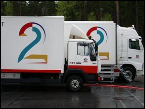
The plans for the TV coverage for the World Cup race in Hovden during O-festivalen 2007 were gigantic, when considering that this is an orienteering event. Norway’s largest commercial TV channel, TV2, had really ambitious plans for the race at Hovden. The plan was to spend 200.000 euros - three times the amount spent for the Norwegian Cup final in soccer(!) - for the production of a single orienteering event.

- When you use micro orienteering and enough cameras, orienteering can be very good television with lots of drama, TV2 top sport producer Jens C. Knudsen said during a presentation he held at a seminar at the Norwegian Orienteering Federation’s big gathering this weekend. Unfortunately for the sport, and for Petter Thoresen and all the others who have been working hard to get orienteering TV coverage the last years, Knudsen had a disappointing message. - There will be no TV coverage at the World Cup event at Hovden next year.

nomicro.jpgNo TV = No micro
- With no TV deal with TV2, we have asked the IOF to be allowed to make the World Cup race in Hovden without micro, Kristiansand OK’s head of O-festivalen 2007, Jack Bjørnsen, could inform the seminar attendees. - This week we got the message back from IOF that we are allowed to go ahead without micro, he continued. This is another big blow for the people behind the micro project - headed by Jan Vidar Nielsen, Morten Dalby and Ulf Rogstad - after micro being taken off the program at the middle distance at WOC 2006 in Denmark. However, they have by no means given up. Instead, they are still working on optimizing the micro competition form, and have in addition introduced macro - which is basically using micro controls as a part of normal orienteering course. These issues were also presented in detail during the seminar, and will be covered in a separate article here at World of O later this week.

txt2.jpg
Orienteering taken seriously
Although the decision for the WC races in 2007 was no, there is no question that the orienteering sport is taken seriously by TV2. Knudsen has already spent some time at the event site in Hovden with the organizers, and identified the best spots for the micro controls from a TV viewpoints. - At one suggested control site, I said that no, I can’t use this control site, Knudsen commented. Instead he found other spots which fit the TV concept perfectly. - Don’t put the control on the hill when you can put it in the pit below the hill, Knudsen continued. - At control 12 at the NOC [control 12 was the start of the micro course at NOC 2005 in Notodden, covered live by TV2], the runners had to get through
a deep pool of mud - and the thought of the viewers typically was How far into the mud will the next runner sink. This was good television!

txt1b.jpg
Spectacular and informative
- We planned to use large TV cranes to film the micro area from above. For each control group, we would put a ring around the controls, and indicate which control was the correct one. Then zoom in on the runner to get close to the action, and afterwards zoom out again to the overview picture, an enthusiastic Knudsen informed the listeners - among them most of the Norwegian national team, among them Norwegian orienteer of the year Holger Hott Johansen, the champion from the live TV covered NOC middle distance 2005 Anders Nordberg, and double WOC silver medalist Marianne Andersen. - The estimated production price for live production from the WC race at Hovden 2007 was 1.5 - 1.6 million NOK [about 200.000 Euro], about 50-60% more than the production costs for the NOC 2005 Middle distance. This includes the use of one new and modern TV production bus with 2 control rooms and 13-14 cameras of which 2 wireless cameras on four-wheeled motorbikes to get the action to the viewers.

nom_08_sb.jpgTricks of the trade
- Let the viewers know more than the runners - that makes good television, Knudsen pointed out in another part of his presentation. This comment was directed towards the micro part of the course, where even a viewer who is totally unfamiliar with orienteering feels that he knows more than the top elite orienteers, as he knows perfectly well which control is the correct one. Knudsen’s next point will maybe hurt some of the orienteers preparing themselves mentally for orienteering on television - as I am sure this mental picture contains an orienteering map somewhere in there: - At the NOC live coverage, we showed a real orienteering map on the screen with GPS tracks on it. We will never do that again! The GPS is perfect. But we need something that is easy to understand for the viewers, and an orienteering map is not. And we need to use the same visualization in every production, such that the viewers get to know it.

top3.jpgPlans ditched for now
- We will not work anymore towards getting full TV coverage from the World Cup at Hovden, Petter Thoresen commented Knudsens presentation. - However, we are still working hard to get orienteering on the TV screens, Thoresen continued. A major part of this work seems to be directed towards TV channels in other countries, and based on the information Thoresen gave during the question round at the seminar, the nordic countries are the main targets. jens_1.jpgKnudsen elaborates on this: - We need 5-6 top quality TV productions from orienteering events a year to get something out of orienteering, as we have to build profiles. One event a year is not interesting. If I could give the head of the sport department at TV2 4-5 other orienteering productions “for free”, it would have been no problem to put in the 200.000 euros.

Bad timing
- June and july are bad months for television [The WC at O-festivalen is planned for June 22nd], people rather sit out in the sun in these months. April, may, august, september and october are good months - and it is important to keep clear of other sports events, especially soccer, Knudsen informs regarding some of the reasons for WC at Hovden being out of the game. - [Also,] the WC in Hovden got too expensive due to the location [about 4 hours drive from Oslo]. If it had been closer to where I have my people, the costs would have been cut significantly.

Knudsen also gave several interesting examples about the power and control TV2 has regarding soccer games in Norway - some of which really got surprised looks from many of the attendees - but not to be repeated here.

trondheim_s.jpgNo game over
- This sport is very exciting, Knudsen said towards the end of his presentation, and made it clear that orienteering is still interesting for TV2. A proof of this is the fact that Knudsen recently has been in Trondheim visiting the possible sites for the World Championships in Orienteering in 2010. - At one of the sites they showed me, I said that this is too ugly. This does not work on television, Knudsen comments on this visit. - Another of the possible sites was perfect, with everything we need.

Compromises
Television being in this early in the process - four years ahead of the championships - must be a very new thing in orienteering. The question which is raised in this regard is how much the sport sells itself to television, and what this means for changes in the technical challenges met by the runners at the big championships. Is the worst forest chosen because the run-in isn’t pretty? Hopefully, the fact that television is inside the loop this early, makes it possible to make the best choices very early, when all options are still open. If television gets into the loop when the finish area is already chosen and most of the course is set, probably much larger compromises must be made.

Photo sources: OPN.no and Norwegian Orienteering Federation/Claes-Tommy Herland.

Big weekend for Norwegian Orienteering

Posted by Jan Kocbach, 20 Nov 2006@8:00

holmen_s.jpgMicro. Macro. The media future of orienteering. Printing of orienteering maps with a laser printer. These were some of the issues covered at Holmenkollen this weekend. It was a big weekend for Norwegian Orienteering with 200 of the most influential people in the sport assembled in Holmenkollen Park Hotel for two days of seminars and discussions, and one evening of glory. The glory part - giving deserved honor to the best of Norwegian orienteering in many different fields - is covered elsewhere (and here and partly in english in the OKansas blog), and will not be touched upon here.

Present at Holmenkollen were most of the people working in the administration in the Norwegian Orienteering Federation, in the regions and in several clubs. Also many mapping people were present, and of course the National Team members and many others who would not let this chance to get to see what is happening within Norwegian Orienteering slip away.

Short summaries
There was a full program with parallel sessions during daytime, and for many it was difficult to choose which seminars to attend to. I suppose that most of the seminars and discussions will be summarized (in Norwegian) at the site of the Norwegian Orienteering Federation within a few days, but as I think much of this will have interest also for the international orienteering community, I will present some thought, comments and summaries of the things I attended here. I might get more into details on some things later this week, but for now just short summaries.

  • issom.jpgMapping seminar: ISSOM 2007 (Håvard Tveite) The new IOF norm for sprint orienteering maps, ISSOM 2007 (valid from January 1st 2007 - a list of changes and O-cad templates can be found) was presented by head of the Norwegian map commission Håvard Tveite. The changes were highlighted, and also differences between ISOM and ISSOM were discussed.
  • okartreg.jpgMapping seminar: Presentation of the Norwegian Map register (Håvard Tveite/Jan Kocbach) The Norwegian o-map register was presented (see my part of the presentation - in Norwegian - here - 5 Mb file), and details were given on status (currently 1150 maps inside, including outlines), implementation, possibilities for use and future plans. It was also demonstrated how to add maps to the register, and everybody present were urged to work hard on adding maps before January 1st 2007 when we loose the right to use the accurate map data used for adding the map positions.
  • print_s.jpgMapping seminar: Alternatives to offset printing (Håvard Tveite) The main part of this presentation was background information to understand why there are accuracy issues with prints from color lasers, and details on the alternatives to the traditional offset printing. In addition, experiences with different types of laser printers were exchanged. This seminar is very important now, due to the fact that more and more clubs have started using laser prints (with varying quality) instead of offset printed maps. There is often too little knowledge about which laser printer to choose to buy (comparison of printers here and here, please send information about your printer as well!), and how to use OCAD optimally to get good results [see here (english version not yet available) and here in english at the bottom of the page].
  • ttime.jpgOrganizing events: So easy that even mom can manage (Kirsti Aas Olsen and Jan Kocbach) The focus in this seminar was how to make the organization of events as easy as possible. The first part was about how non-orienteers/family members can easily do many jobs in organizing an orienteering event. The second part was examples on how to in a simple way handle competitions with 2-300 competitors with only 3-4 people organizing. See my part of the presentation - in Norwegian - here - which was based on examples from local competitions in Bergen. This last part is also covered in an article I have written for the upcoming issue of the Norwegian o-magazine Veivalg.
  • micro.jpgMicro is also not difficult (Margrete Ruud Skjeseth) This presentation was on how a quite big micro competition was made for 13-16 years old. All parts of it were covered, from the planning of the course to details regarding time-taking and counting penalty rounds. It looked like great fun for the youngsters, although the number of organizers required was quite high. There was also quite an interesting part at the end of the presentation with some discussion around the micro concept with one of the men behind micro - Jan Vidar Nielsen. This included the concept of macro, which is furher covered below.
  • The media future of orienteering I - Micro Unfortunately I only managed to participate at the very last part of this presentation, but there seemed to be a lot of discussion and examples regarding the micro concept. Also tips about how to do the orienteering and how to think simplification on a micro course (most of the Norwegian national team was present, picking up details), and statistics and results analysis from various micro competitions. I have asked to be sent this presentation on an email - so maybe I can share more with you about this later on.
  • The media future of orienteering II - Macro I missed this as well, but it seems like a new concept - macro - was introduced. Macro is very similar to micro, except there is no map and scale change, and the micro controls are part of the normal orienteering course instead of being a separate loop as in micro. We got a very nice 22-page color leaflet about traininig possibilities and possible competition forms for micro and the newly introduced macro - it should soon be available for download for everybody it was said. I hope to get more information about this as well.
  • nom_09_s_1.jpgThe media future of orienteering III - Television (Jens C. Knudsen) This was the highlight of the weekend for me - extremely interesting stuff about how the top TV producers think - and this applied to orienteering! Jens
    C. Knudsen is, according to the invitation to the seminar “star producer in TV2 and responsible for 2-3 soccer productions nearly every weekend. He knows what is needed to keep the viewers”. Quite an introduction, but I think nobody went home disappointed. It is interesting to listen to how cynical the television world is - and to see how it is the money that sits at the bottom. They won’t put up orienteering to be kind to the orienteering world ; it is all about money and developing a concept which can become really popular. It seems like it is either being high up there, or nothing at all. I have written a long separate story on this seminar.

  • Web TV - the media future for Orienteering (Fritjof Sandstad) The angle on this presentation was quite the opposite of the previous presentation. Here the concept was to make a good 4 hour Web TV production - streamed live over the internet - from the unofficial Norwegian Championships in Orienteering 2006 for Youths (14-16 years old). For about 15.000 euro, all covered through sponsors, the organizers managed to get produced a 4 hour web TV production using 6 different cameras(!), and quite a professional-looking result. The production was watched by 7000 persons (not for the total 4 hours), and was a real success. Many details were covered in the presentation, all the way down to placement of TV cameras for optimal sponsor profilation and how to get an internet connection in the middle of nowhere (at least quite close to there). And of course, we got to see part of the video from the web-TV at the end.

O-travel and Training camps in WoO Calendar

Posted by Jan Kocbach, 15 Nov 2006@8:00

mont.jpgIt is now also possible to add Training camps and Orienteering-travels in the WoO Calendar. Thus, now clubs, organizations or individuals who organize training camps can add their offers in the calendar. When more entries are added, this will make it easier to plan a training camp. Currently there are only a few training camps entered:

  • Winter training camps in France, organized by Damien Renard between January and March 2007
  • NOM Test training camp in the Halden area organized by Halden and Sarpsborg
  • this autumn.

Addition of training camps and o-travel (click here) is done exactly like when adding normal competitions, except “Training” or “Orienteering travel” is chosen as “Race type”. So add your training camps in the WoO calendar - this will let more people know about them!

Links:

mont2.jpg
Map samples, location, travel help etc.
As for normal competitions, you get map samples, the exact location of the training camp, and so on. In addition, the organizers can provide you with other relevant information, and a link to their homepage. Below you see some examples for some of the training possibilities to be found in the WoO calender now. For me personally it was very nice to finally see exactly where the training camp possibilities in France are, and especially related to the airports, as I have been thinking about going there in the past. The map samples coupled to the location also gives me very useful information in that regard. With even more organizers adding their training camp possibilities in the future, this will be an even more valuable tool.

tra3_s.jpg
tra4_s.jpg
tra2_s.jpg
tra5_s.jpg

All maps from WMOC Brasil

Posted by Jan Kocbach, 14 Nov 2006@18:00

At Daniel Hubmann’s page, finally good quality scans of all maps from WMOC competitions in Brasil are available. As a bonus, the maps includes the routechoices of the winner from the long distance at WMOC (yes, that was Daniel Hubmann).

Link:

To JWOC with Catching Features [video]

Posted by Jan Kocbach, 10 Nov 2006@8:00

ka4_s_s_1.jpgThere is a very interesting project going on among some junior orienteers preparing for the Junior World Orienteering Champs in Australia next summer. Basically, they plan to

  • Redraw some of the relevant maps for JWOC available on the official JWOC site in OCAD
  • Convert them to Catching Features format using the automatic OCAD->CatchingFeatures converter which is now available.
  • Play, play and play until they know the terrain type as their own garden.

Large parts of the first map - Kahli’s Rocks - is finished, and a course is available for all Catching Features owners to play. I have played through the course, and made a video of my playing it and the course review to accompany this article - especially for those of you who have not tried Catching Features yet, or have only tried the demo version. Take a look at it - you get an impression, although the video quality at YouTube is not the best:

Update: Video in higher quality can be found here.

jwoc2007.jpg- Yes, it was me who started this project, austrian junior Tobias Killmann replies when asking about the project. - There are actually more guys consuming of this JWOC project than people are working on it. The main persons and OCAD drawers are Øyvind Enger (Modum O-lag), Thomas Carlsson (Rehns BK), Christian Schive (Halden SK), Konring (Denmark) and me, Tobias continues. - There are also some really good juniors like Genar Jeremy, who play CF regulary and have top JWOC results, who will profit of this project. Some of the guys working on the project are however actually too young to qualify for the JWOC.

- Catching Features (CF) gives you a perfect possibility to prepare for competitions in terrain you are not familiar with. You learn how to read the map in those specific terrains, and you learn how to take the right routes in it, Tobias continues. Another junior using CF to prepare for orienteering competitions is the belgian junior Jochen Verdeyen - finishing in a very surprising 4th place at the sprint at JWOC in Lithuania this summer.

ka9_s_s.jpgVery relevant O-technical training
- I’m absolutely sure that Catching Features improved my o-technique, and the way how I behave myself with a map, Jochen comments on his JWOC result. - In the preparation for last years JWOC, I draw a small map in OCAD (sample of jwoc), and converted it into CF. So, I think I was the first with the idea for making JWOC maps in CF, Jochen exclaims. - This sort of training is the best possible - except for going there and train a lot on relevant maps. You get a good feeling with the relevant terrain if you play on it regularly. I also know that some elite-runners use other preparations like analysing thousands of routechoices on the relevant maps, but that’s not the same…

Improves my Orienteering
Tobias continues to tell about how CF improves his orienteering a lot; - The first and in my opinion most important aspect how CF improves your O-skills is that you get incredible fast to read the map. CF is 4 times faster than the real life. That means that 1 CF second is 0,25seconds in real life. To be good at CF you have to able to read the whole route to a control in less than half a second! This leads you to the second most important point how CF improves your O-skills, the route choices. You don’t have to go out into the forest to learn to take the right route choices. In CF you can run courses in 10 min with many tricky route choices. You learn to take the right choices in a shorter time!”. Jochen fills in; I like sprint the most, and CF is a very good training for that, because you’ve got to react very fast for creating your routechoice ‘in your head’.

- One other very important point is that you learn how to deal with competition situations. You can run many competitions every day, and you always have the same mental stress as in real life. You learn how to react after mistakes and to keep cool. The ranking system in CF is always a motivation to train harder and it is simply incredible how you can watch how the CF players improve in real life, Tobias continues.

Hard work
By comparing the original map with the Catching Features map, we can see that good work has been done (upper is CF, lower is original map):

cmp1.jpg

cmp2.jpg

Raises questions
With orienteering games becoming so realistic that it is actually possible to use them extremely well in preparing for competitions, some questions will have to be raised. Will the big orienteering nations with lots of resources start making OCAD files of old maps to prepare themselves for the World Champs in an orienteering simulator - be it Catching Features or another product? Marianne Andersen of Norway prepared herself for this years WOC long distance by making a map in OCAD of the terrain, but to my knowledge she did not take it a step further and actually use the map in an “orienteering simulator”. Other runners have also made OCAD maps to prepare themselves for big competitions, but playing the World Champs map in an orienteering simulator until you know it like your local forest is bound to have a significant better effect… I am actually surprised that not more of the elite orienteers use this opportunity today to improve their orienteering skills. There are hundreds of different maps available to play on - both converted from real OCAD files, “fantasy maps” and random maps. And forget the demo version and the built in maps - it is the competitions that are fun. Try the full version somewhere, and you’re sold (at least I was;).

Get more people running orienteering
Another thing about CF is that it should be used actively in getting more people run orienteering. Here you can really see what an action sport orienteering is!

Just for the record when writing so positive about a product: I have no commercial interest in Catching Features whatsoever. I have tried to contact the man behind the software some time ago regarding a different matter, but without managing to get any answer. The opinions given in this article are purely my personal opinions.

ka8_s.jpg

ka13_s.jpg

Map from WMOC in Brasil

Posted by Jan Kocbach, 09 Nov 2006@10:52

bra1.jpg… here is one of the training maps from the WMOC in Brasil while waiting for the maps from yesterdays middle distance and todays long distance. [From I-OL forum - training map of Clemens Roos]. See also the middle warm-up course from Martin Pongratz page - We analyzed the races already and one thing is sure – the course offered a lot more challenges than expected….

Update 14/11: All maps from WMOC available at Daniel Hubmanns page.

Congratulations to Tatiana Riabkina og Andrey Khramov for victories at yesterdays middle distance.

See also

New features in WoO Calendar

Posted by Jan Kocbach, 08 Nov 2006@8:00

wiki2.jpgWikipedia integration, maps from competitions and results browsing are some of the new features that have been added in the WoO Calendar. Also thanks to all of you who have added competitions - more than 50 competitions have been added the last few days - more than 20 of them just yesterday.

More info
To give you more information about what is going on in the region of the competitions the following features are added (you can see an example here):

  • Show wikipedia entries in the neighbourhood of the event on the map (see illustration at the bottom of the page)
  • Get current weather conditions and typical weather conditions for the event area
  • Hotel search in the area of the event (unfortunately this is not extremely accurate - I hope to be able to make this better some time)
  • Possibility to view another map source for the area (Microsoft VE), as other map sources are sometimes more accurate for specific regions (like e.g. Slovenia, South Africa etc.). More map sources will be added (send me a tip if you know about some which should be added)
  • Coming up soon is also the possibility to show orienteering maps close to the event - taken from the orienteering map register in WoO-Geo.
  • Any other location based features you need when planning where to go orienteering? Tell me, and I will see what is possible…

Maps and results browser
post2.jpg
In addition it is now possible to add information for past competitions as well, like maps with courses/link to route choice analysis, race reports and results (see below). Presently 8 events with maps or results are in, but the number of events is growing every day:

post_1.jpg

wiki_1.jpg

Hello South Africa

Posted by Jan Kocbach, 07 Nov 2006@8:00

There has not been much news about South Africa here at World of O. However, after the launch of the WoO Calendar last week, a few South African events have been added to the calendar, and this is definitely worth a news story. I also got a nice e-mail from Alvin Ward situated in Cape Town, South Africa.

Small sport
Alvin says that orienteering is still a very small sport in South Africa - and essentially there are only clubs in Johannesburg and Cape Town. The South African event calendar for 2007 will be released in a few weeks time, but for now some of the remaining events for 2006 have been added. - We only have about 30 events a year, but if we could add our events to the calendar as the information becomes available, we might even be able to encourage more people to come to our events, one day, Alvin continues. So expect to see many South African events in the WoO calendar in the time to come - just now there are already 8 South African events inserted (see all South African events in the WoO calendar here).

Tokai East Park Event
Taking a look at the satellite pictures (map details are sparse for South Africa in Google maps, so use Satellite images) for Tokai East Park Event, the scenery sure looks nice, as you can see here:
sa1.jpg
sa2.jpg

And a map sample:

And here is a detailed satellite picture from the event area of another south african event - the BushTrails Magaliesburg:

sa3.jpg

Check it out
A local event in South Africa is probably not what you want to spend a lot of money for if you are traveling from Norway or somewhere else in northern Europe, but just for the fun of it I wanted to check what it would cost me to travel there for the event next weekend. I clicked to find major airports close to the event, and found one just 19 kilometers from the event site - the Cape Town International. Going on to a flight search, here is what I found:

sa4.jpg
sa5.jpg

OK - a bit to expensive for me just this week;)

Popular for training camps
South Africa is also a popular place to go for a training camp for top orienteers from European countries - so the addition of South African events in the WoO Calendar might get somebody from far away to consider visiting a local event in South Africa as well. In Capestorm O-Ringen in march this year, there were 125 participants from 11 countries - including the finnish national team and a few runners from Halden SK. Earlier for example Anders Nordberg and Jonn Are Myhren have been training in this area as well (see OPN article - link below).

Links:

Introducing: World of O Calendar

Posted by Jan Kocbach, 03 Nov 2006@12:00

calsmall.jpgNews Release: Just in time for the planning of your next summer holiday, World of O launches the World of O Calendar - an international orienteering event calendar giving you something extra. In addition to all standard event calendar features, location based searches are possible by clicking on a map to define a search point. A further click of a button gives you events which are in the same area and time period as a selected event. Yet another click on the mouse button, and airports close to the event site are shown on the map, including integrated flight searches. Another cool feature is the possibility to see map samples and terrain/scenery pictures directly from the event calendar. Addition of events, correction of event details and upload of map samples/pictures is free for everybody, and very straightforward. All the responses received already before the official launch indicates that the orienteering community will keep the World of O Calendar up to date from day one.
calrr.jpg

Summary of main features:

  • Search for orienteering events based on geographic position, date, name, country, WRE status or a combination of these.
  • Show the location of orienteering events directly on a map.
  • See map samples and terrain samples from the orienteering events.
  • Show the location of other orienteering events in the same area and time period on a map, or as a list sorted on date.
  • Find the distance between events or between your home and different events
  • Show the closest airports to a given orienteering event at a map, and also search directly for flights to the orienteering event.
  • Add your own events including the exact location using a simple-to-use interface - including the possibility to upload map samples and terrain pictures.
  • Terrain description and tourist information is available for the events where the organizers have provided this.

Note! The World of O Calendar is still in beta-testing phase (but open for everybody to use), so don’t count on the service being stable at all times - and there may also be problems with some browsers. Also, all event locations are not completely accurate just now, as many are entered based on geocoding. The orienteering community has started correcting this already before the official launch. To fix the location of an event will take you about 1-2 minutes at a maximum (I need 30 seconds for it when I now where the event is held) - so it should be no big deal.

Enjoy!
All early testers have returned with extremely positive responses - “fantastic”, “crazy good” and WOW! are some of the responses. This is even better than at the relaunch of World of O this spring.

  • Go try World of O Calendar!
  • Make corrections for events where you find wrong info
  • Add your events - even local events, especially if they are natural to attend to before/after one of the bigger events.
  • Send me an email or add a comment below if something is not working - or if you have suggestions for new features. Especially browser issues are welcomed.
  • Look at the screenshots below for more details about what you will find in World of O Calendar.
  • Read this article at OPN.no about World of O Calendar which gives some background information and many screenshots and explanations.

Screenshots of main features

caldesc.jpg

Next Page »