Today’s leg in Route to Christmas is “a long way from anywhere” – and probably one of the most spectacular legs we have seen in competitions this year. The 3rd leg in the longest course in the Western Canadian Orienteering Championships Long 2017 does simply look amazing. What a leg!
On the competition page, the organizers wrote the following on the competition page ahead of the race: “Yes, the Manitoba prairies may seem like they are a long way from anywhere but don’t let that put you off, it is well worth the trip. Apart from some of the most challenging orienteering you will ever experience (see mapper’s notes), Spruce Woods Provincial Park is a place well worth visiting for its own sake.”
The mappers notes are also worth reading before choosing your rote on the leg below:
Mapper’s Notes
Back in the 80’s when I was doing the tour of Europe like all aspiring elite orienteers do, someone gave me a map of sand dunes in Manitoba. It blew my mind. Not only did the terrain seem uniquely challenging, I was intrigued by the idea of sand dunes so far from the sea (being Australian I had no idea that melting glaciers dump huge quantities of sand). So last year when I was offered the opportunity to do some mapping in those very sand hills I jumped at the chance. Often when you have waited 30 years for something the reality proves to be a bit of a let down. Not in this case. The terrain more than lived up to my expectations. The sand hills of Spruce Woods Provincial Park are an area that should be on every orienteers’ bucket list. It was a joy to map – and if you come I think you will find it a joy to orienteer in.
Often when you have waited 30 years for something the reality proves to be a bit of a let down. Not in this case.
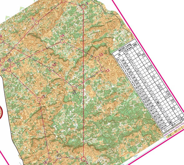
The area covered by this map is true wilderness. Apart from the road and trails that form the map border there are almost no man-made features – just contours and vegetation. The map is predominantly yellow or green. The yellow is mixed grass prairie – very fast running. The wooded areas are a mix of spruce, aspen and oak – usually light to medium green. Always passable but best avoided where possible. This combination of open and wooded areas creates its own navigational challenges. You won’t be able to just run straight on a compass bearing. You will need to find ways to weave around the thicker vegetation. The topography ranges from quite flat to very steep sand hills up to 30m high. There are large areas of the very intense contour detail typical of sand dunes, where close map contact and super accurate navigation will be essential. There are also tracts of flatter terrain with vague contour detail. These are often heavily wooded with narrow passages of good running. These labyrinth-like areas will require a very different style of navigation.
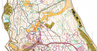
The leg is as usually first provided without routes – you may take a look at it and think about how you would attack this leg (if the image is too small, you may click on it to get it larger):
Location
You find other maps from the area in omaps.worldofo.com here. See also latest additions in 3DRerun from this area in order to learn more about this terrain type.
Webroute
Next you can draw your own route using the ‘Webroute’ below. Think through how you would attack this leg, and draw the route you would have made. Some comments about why you would choose a certain route are always nice for the other readers.
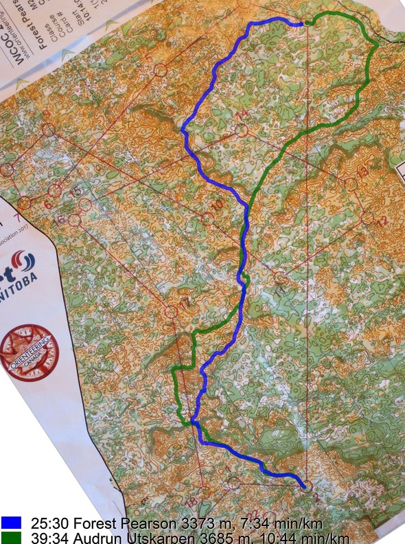
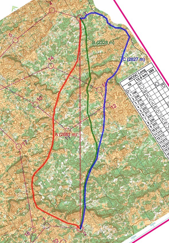
There were only a very few GPS-routes available for this leg (see further below), so I’ll just provide some small discussions here – and hopefully somebody with real knowledge about the terrain can jump in and give us a good explanation of where to run and why. I have drawn three possible routes below – all trying to use the runnable parts (yellow, light green) as much as possible while avoiding dark green and steep hills. In addition to the runnability, there is the difficulty to take into account here. I think many would benefit from taking the blue one – quite runnable, quite straight, and a safe way to the control by taking it from the path. What would you do?
Then you can take a look at how the runners have solved this leg below.
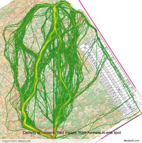
Density map
See below for a density map of some of the ones who have drawn their routes so far.
Additional information
You find the complete map in omaps.worldofo.com at this location.
Route to Christmas series
The Route to Christmas series at World of O is a pre-Christmas tradition at World of O – giving the readers the opportunity to do one Route Choice Challenge each day from December 1st until December 24th. If you have got any good legs in RouteGadget, GPSSeuranta or 3DRerun from 2017-competitions – or old forgotten ones which are still interesting – please email me the link at Jan@Kocbach.net, and I’ll include it in Route to Christmas if it looks good. Route to Christmas will not be interesting if YOU don’t contribute.
Not all legs are taken for the interesting routechoice alternatives – some are also taken because the map is interesting – or because it is not straightforward to see what to do on a certain leg. Any comments are welcome – especially if you ran the event chosen for todays leg!
 World of O News
I didn’t run this race, but I’ve been in this area before. And the green is definitely best avoided, if at all possible. The mapper is right that “straight is great” is rarely a good option. You get bounced around by the variable thickness and it is really difficult to keep a straight line. The visibility in the green areas can also be low, and I’m reasonably sure that the contour interval is only 2.5m. So you may be right beside a hill or depression you were expecting to see and completely miss it.
I recall from the Canadian Championships in 2009 that some runners ran a portion of the race shirtless because their jerseys were covered with so many burrs that they would start to rub together and completely cut up people’s skin. It was better to wear no shirt at all! I spent hours pulling them off my jersey, trousers, and socks.
That would explain why the few routes that you see are trying to get as close to the control as possible before leaving the yellow.
I had the privilege of running this. I tend to be “conservative” when it comes to early race route choice. The yellow was slower than you might think due to tall grass, but it was okay…just sapped your energy. Heat was “okay” as were burrs. Green was definitely worth staying out of. Not because it was particularly thick, but because you were in dark, low spots with no visibility and no features=No Man’s Land. The contour interval was 2.5 m, but given the overmapping, it would have totally been fine at 5 m w/ lots of form lines. None the less, this was a fun race, relentless navigation; you never got a rest on trails, just non-stop map reading.