 World of O News
Tove Alexandersson (Sweden) and Matthias Kyburz (Switzerland) won the first Knock-Out Sprint in a championship when winning the European Orienteering Championships (EOC) Knock-Out Sprint in Neuchatel today.
Kyburz won a tight battle with another Swiss runner – Joey Hadorn. Norwegian Kasper Fosser took bronze, and finished with that a long wait for Norway – the first ever individual sprint medal in the men’s class in EOC or World Orienteering Championships (WOC) for Norway. The silver and bronze in the women’s class also went to Switzerland and Norway, with Simona Aebersold taking silver and Andrine Benjaminsen bronze.
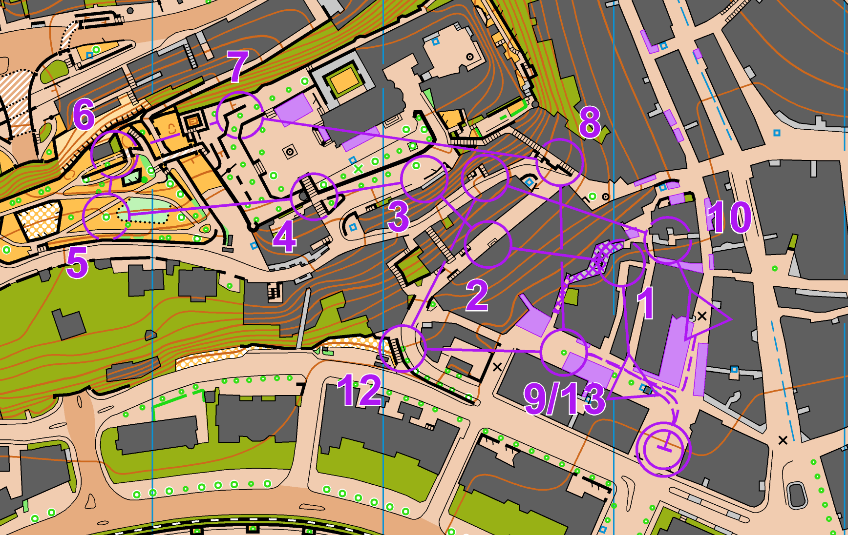
Men’s race: Decided in the last uphills
In the men’s race the race was open the first half of the final, with Ricardo Rancan (Switzerland) and Vojtech Kral (Czech Republic) battling alongside the three medalists until control 7. To control 8 Kyburz ran a better route to the right and got a small advantage.
However, on the route choice leg to control 9 Fosser and Rancan ran a better route around to the right and were suddenly “clear” first and second on control 10 (route B below, but down the steps before turning right).
Kyburz and Hadorn were chasing, with Kral losing contact with the lead. From here on to the finish Kyburz and Hadorn were physically stronger and managed to pass the two leaders in the last uphills toward the 12th control – and open a gap towards the finish.
Women’s race: Alexandersson physically strongest
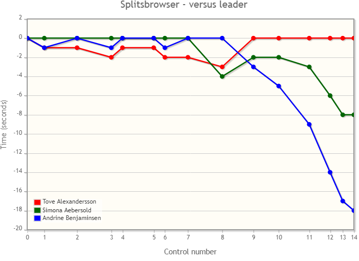
In the women’s class it was all about Alexandersson, Aebersold and Benjaminsen from the start. The three ran nearly together until control 8 (here Alexandersson and Benjaminsen showed exceptional skills down the stairs, running clearly faster than Aebersold). After being in the lead a control 8, Benjaminsen lost the initiative to control 9 where she took the route to the left while the two others ran to the right (the women had the same course as the men).
From here to the finish Benjaminsen never managed to catch up with the two leaders – while Alexandersson was clearly better physically – finally sprinting to the victory.
Maps and GPS-tracking Final & Semifinal
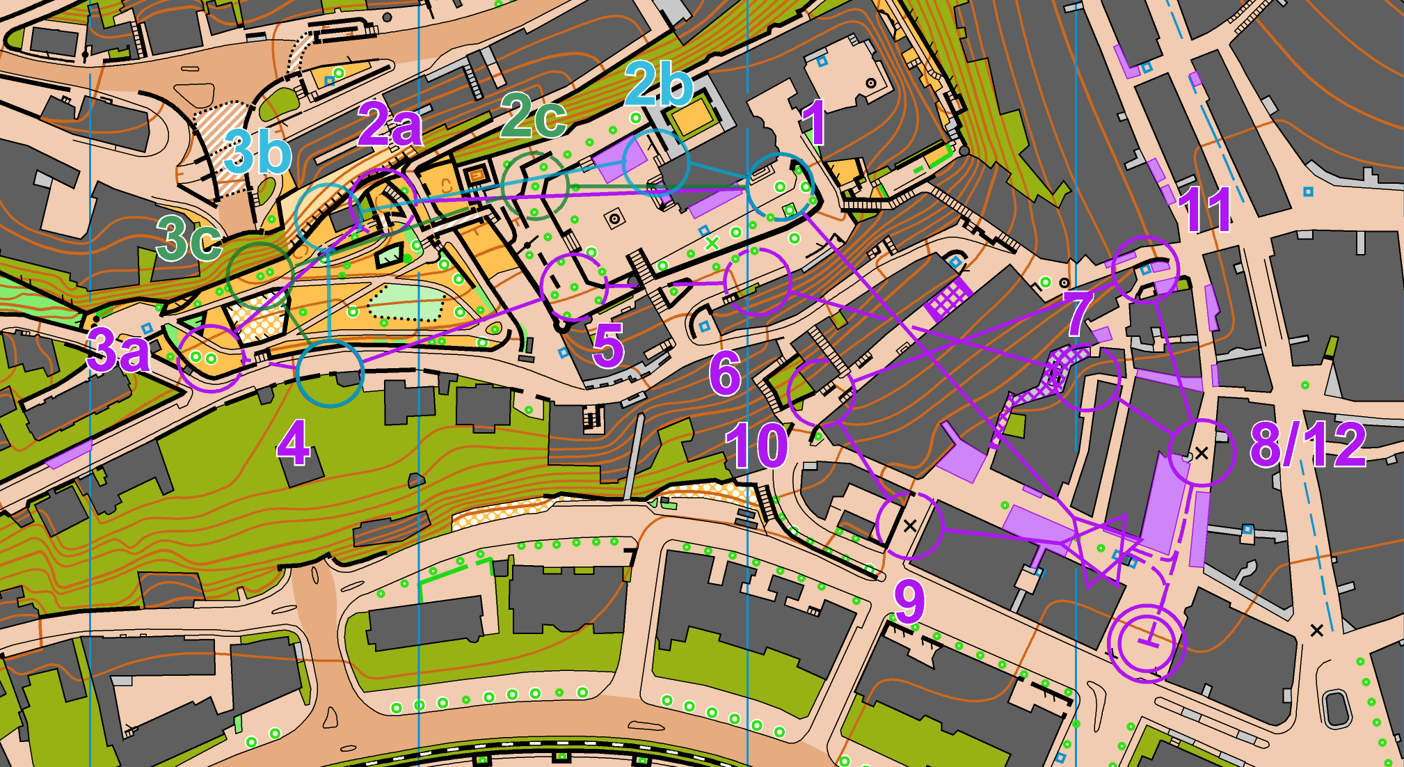
GPS-tracking is available from TracTrac. See maps from the semifinal (upper) and final (lower) below. Unfortunately maps from the Quarter-final have not been posted online by the organizers – this page will be updates when/if they are available.
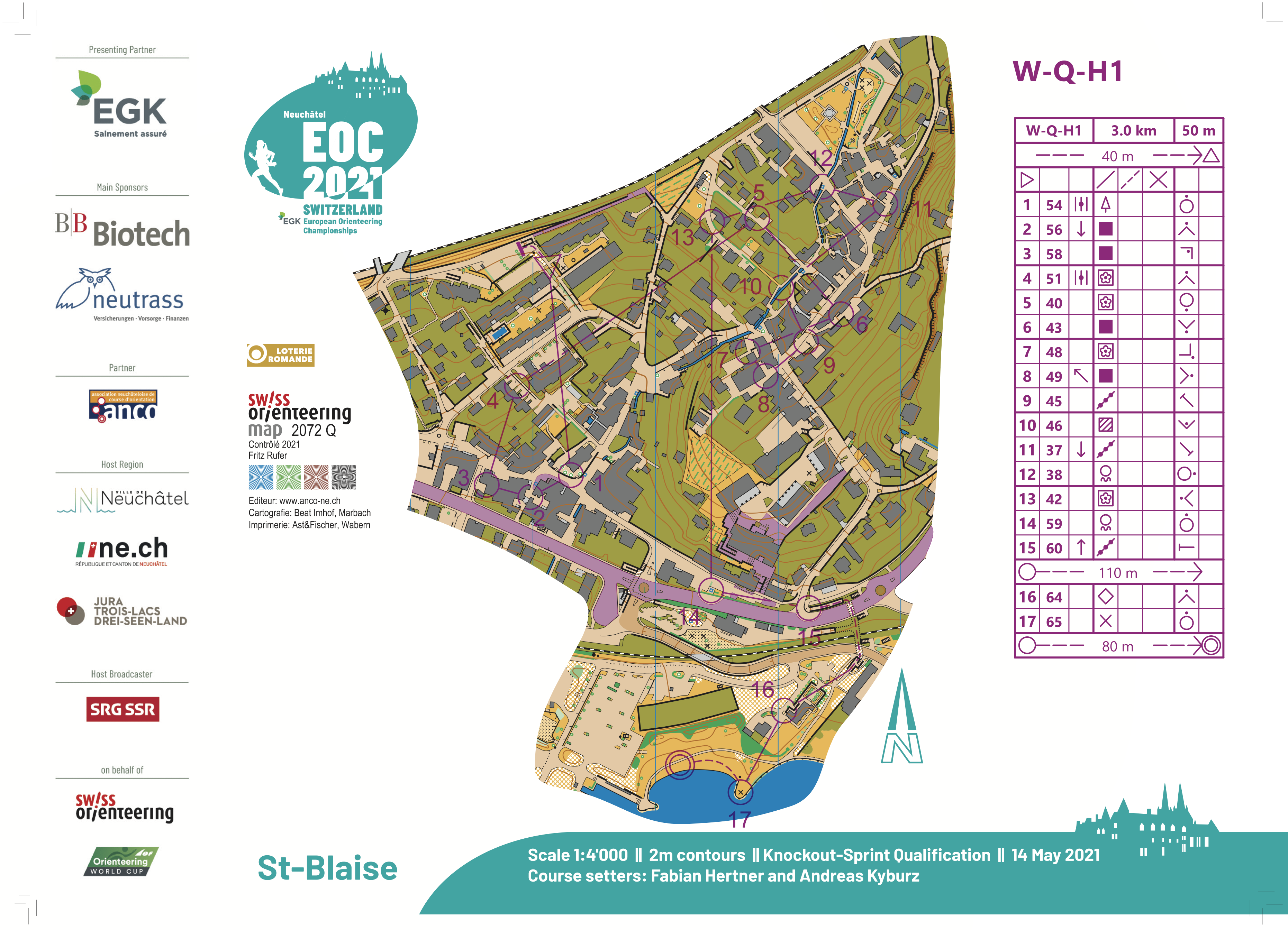
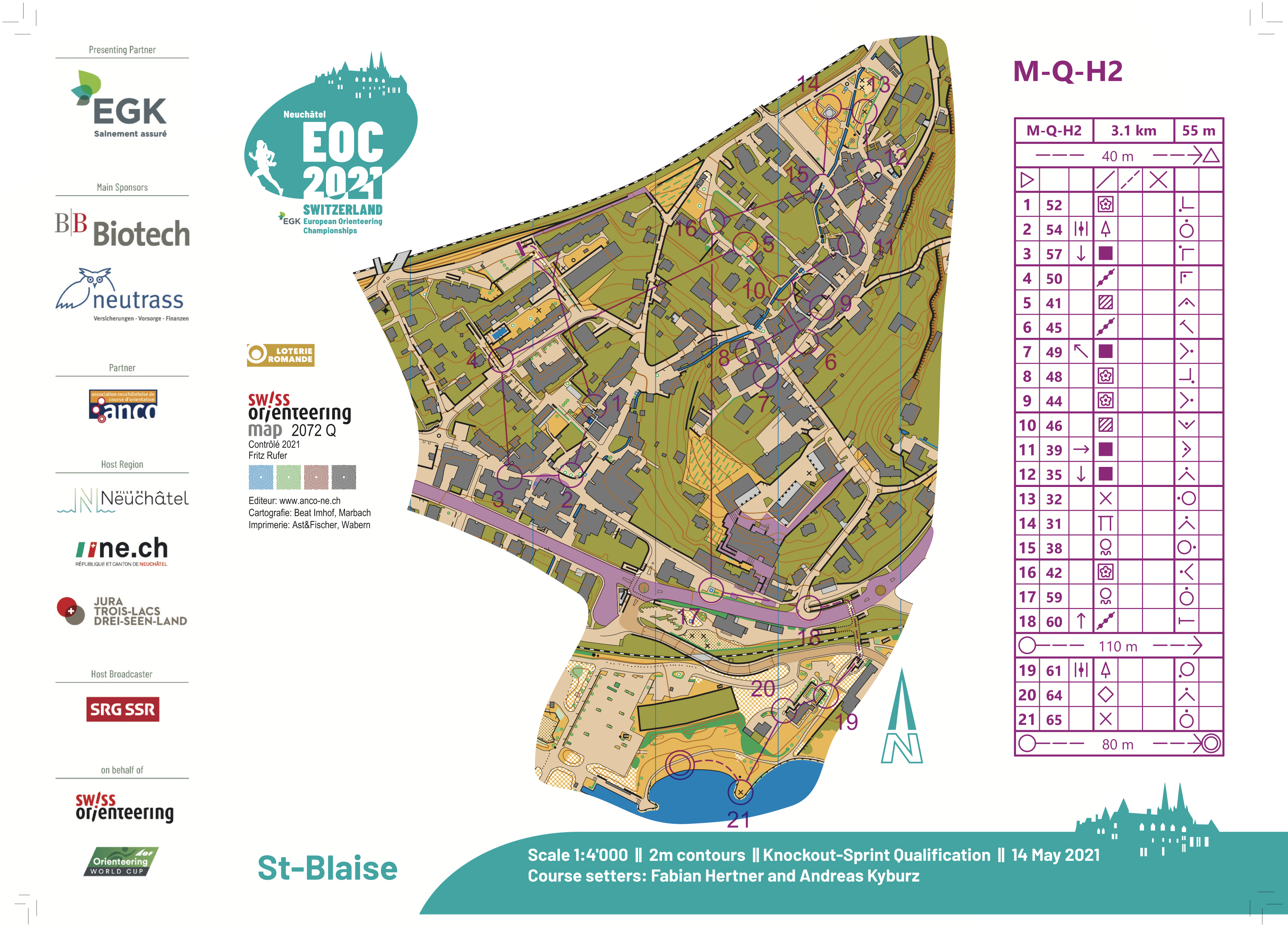
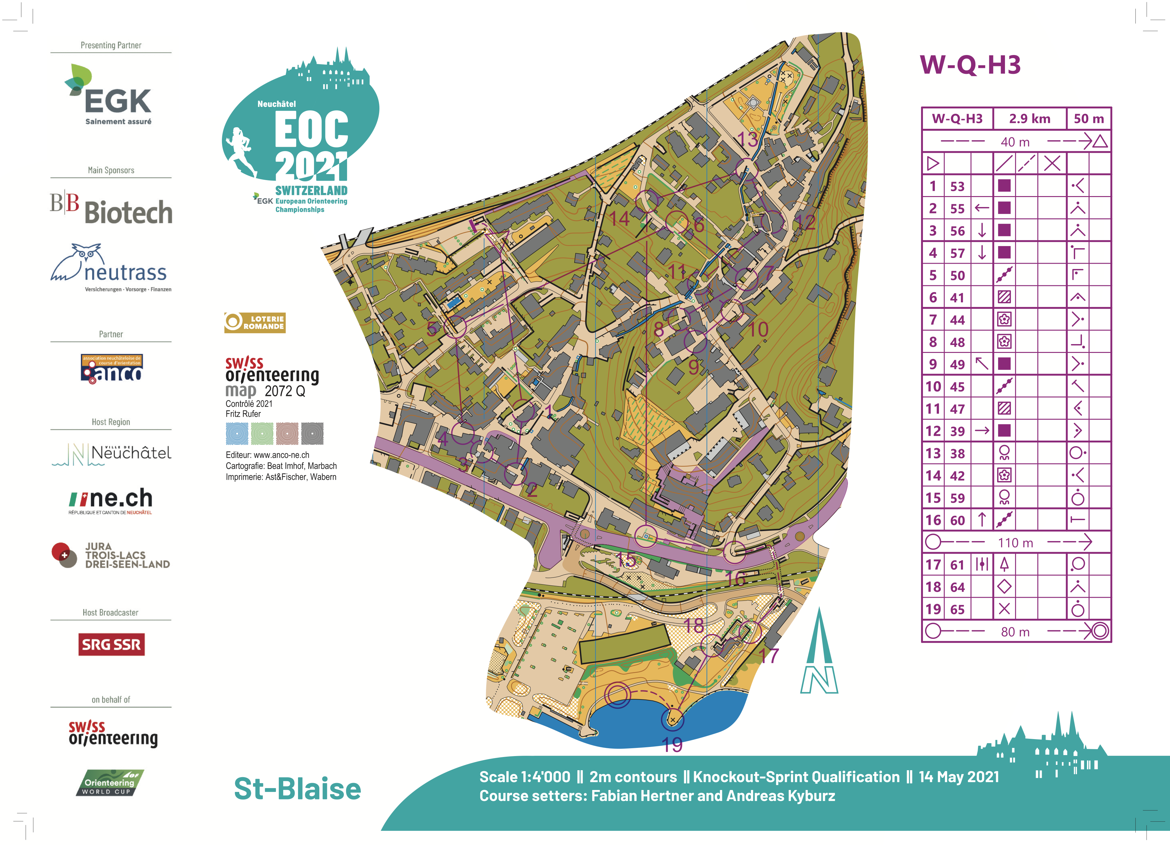
Maps and GPS-tracking Qualification
See maps from Friday’s Knock-Out Sprint Qualification below – GPS-tracking is available from TracTrac.


Results
Men Final
| 1 | Matthias Kyburz | 6:30 | 1:28 | |||
| 2 | Joey Hadorn | 6:31 | +0:01 | 1:28 | ||
| 3 | Kasper Harlem Fosser | 6:33 | +0:03 | 1:29 | ||
| 4 | Riccardo Rancan | 6:34 | +0:04 | 1:29 | ||
| 5 | Vojtech Kral | 6:37 | +0:07 | 1:30 | ||
| 6 | Audun Heimdal | 6:52 | +0:22 | 1:33 |
Women Final
| 1 | Tove Alexandersson | 7:19 | 1:49 | |||
| 2 | Simona Aebersold | 7:27 | +0:08 | 1:51 | ||
| 3 | Andrine Benjaminsen | 7:37 | +0:18 | 1:54 | ||
| 4 | Natalia Gemperle | 7:54 | +0:35 | 1:58 | ||
| 5 | Vilma von Krusenstierna | 7:57 | +0:38 | 1:59 | ||
| 6 | Tereza Janosikova | 8:02 | +0:43 | 2:00 |
Men Semi-final 1
1 700 m, 6 starting competitors
| Plac | Name | Organisation | Time | Diff | Km time | FH |
|---|---|---|---|---|---|---|
| 1 | Vojtech Kral | 7:30 | 4:24 | A | ||
| 2 | Riccardo Rancan | 7:31 | +0:01 | 4:25 | A | |
| 3 | Jerker Lysell | 7:38 | +0:08 | 4:29 | ||
| 4 | Axel Granqvist | 7:40 | +0:10 | 4:30 | ||
| 5 | Samuel Pihlstrom | 7:58 | +0:28 | 4:41 | ||
| 6 | Tuomas Heikkila | 8:01 | +0:31 | 4:42 |
Men Semi-final 2
1 700 m, 6 starting competitors
| Plac | Name | Organisation | Time | Diff | Km time | FH |
|---|---|---|---|---|---|---|
| 1 | Joey Hadorn | 7:36 | 4:28 | A | ||
| 2 | Matthias Kyburz | 7:37 | +0:01 | 4:28 | A | |
| 3 | Dag Blandkjenn | 7:40 | +0:04 | 4:30 | ||
| 4 | Lukas Liland | 7:44 | +0:08 | 4:32 | ||
| 5 | Soren Thrane Odum | 7:47 | +0:11 | 4:34 | ||
| 6 | Lucas Basset | 7:53 | +0:17 | 4:38 |
Men Semi-final 3
1 700 m, 6 starting competitors
| Plac | Name | Organisation | Time | Diff | Km time | FH |
|---|---|---|---|---|---|---|
| 1 | Kasper Harlem Fosser | 7:03 | 4:08 | A | ||
| 2 | Audun Heimdal | 7:05 | +0:02 | 4:10 | A | |
| 3 | Havard Sandstad Eidsmo | 7:12 | +0:09 | 4:14 | ||
| 4 | Jonas Hubacek | 7:17 | +0:14 | 4:17 | ||
| 5 | Jonas Egger | 7:28 | +0:25 | 4:23 | ||
| 6 | Daniel Hubmann | 8:01 | +0:58 | 4:42 |
Women Semi-final 1
1 700 m, 6 starting competitors
| Plac | Name | Organisation | Time | Diff | Km time | FH |
|---|---|---|---|---|---|---|
| 1 | Simona Aebersold | 8:13 | 4:50 | A | ||
| 2 | Tove Alexandersson | 8:14 | +0:01 | 4:50 | A | |
| 3 | Paula Gross | 8:25 | +0:12 | 4:57 | ||
| 4 | Sarina Kyburz | 8:28 | +0:15 | 4:58 | ||
| 5 | Lotta Karhola | 8:37 | +0:24 | 5:04 | ||
| 6 | Megan Carter Davies | 9:02 | +0:49 | 5:18 |
Women Semi-final 2
1 700 m, 6 starting competitors
| Plac | Name | Organisation | Time | Diff | Km time | FH |
|---|---|---|---|---|---|---|
| 1 | Andrine Benjaminsen | 8:00 | 4:42 | A | ||
| 2 | Natalia Gemperle | 8:06 | +0:06 | 4:45 | A | |
| 3 | Hanna Lundberg | 8:10 | +0:10 | 4:48 | ||
| 4 | Sara Hagstrom | 8:25 | +0:25 | 4:57 | ||
| 5 | Veera Klemettinen | 8:51 | +0:51 | 5:12 | ||
| Sabine Hauswirth | mispunched |
Women Semi-final 3
1 700 m, 6 starting competitors
| Plac | Name | Organisation | Time | Diff | Km time | FH |
|---|---|---|---|---|---|---|
| 1 | Tereza Janosikova | 8:02 | 4:43 | A | ||
| 2 | Vilma von Krusenstierna | 8:03 | +0:01 | 4:44 | A | |
| 3 | Elena Roos | 8:04 | +0:02 | 4:44 | ||
| 4 | Karolin Ohlsson | 8:05 | +0:03 | 4:45 | ||
| 5 | Lina Strand | 8:08 | +0:06 | 4:47 | ||
| 6 | Eline Gemperle | 8:36 | +0:34 | 5:03 |
Men Quarter-final 1
1 800 m, 6 starting competitors
| Plac | Name | Organisation | Time | Diff | Km time | FH |
|---|---|---|---|---|---|---|
| 1 | Jerker Lysell | 7:08 | 3:57 | A | ||
| 2 | Riccardo Rancan | 7:09 | +0:01 | 3:58 | A | |
| 3 | Tuomas Heikkila | 7:10 | +0:02 | 3:58 | A | |
| 4 | Florian Howald | 7:11 | +0:03 | 3:59 | ||
| 5 | Algirdas Bartkevicius | 7:18 | +0:10 | 4:03 | ||
| Jonatan Gustafsson | mispunched |
Men Quarter-final 2
1 800 m, 6 starting competitors
| Plac | Name | Organisation | Time | Diff | Km time | FH |
|---|---|---|---|---|---|---|
| 1 | Vojtech Kral | 6:54 | 3:50 | A | ||
| 2 | Axel Granqvist | 6:55 | +0:01 | 3:50 | A | |
| 3 | Samuel Pihlstrom | 6:56 | +0:02 | 3:51 | A | |
| 4 | Martin Hubmann | 6:57 | +0:03 | 3:51 | ||
| 5 | Eskil Kinneberg | 7:02 | +0:08 | 3:54 | ||
| 6 | Maxime Rauturier | 7:09 | +0:15 | 3:58 |
Men Quarter-final 3
1 800 m, 6 starting competitors
| Plac | Name | Organisation | Time | Diff | Km time | FH |
|---|---|---|---|---|---|---|
| 1 | Joey Hadorn | 7:02 | 3:54 | A | ||
| 2 | Lukas Liland | 7:03 | +0:01 | 3:55 | A | |
| 3 | Matthias Kyburz | 7:05 | +0:03 | 3:56 | A | |
| 4 | Jakob Edsen | 7:06 | +0:04 | 3:56 | ||
| 5 | Mathieu Perrin | 7:15 | +0:13 | 4:01 | ||
| 6 | Robert Merl | 7:19 | +0:17 | 4:03 |
Men Quarter-final 4
1 800 m, 6 starting competitors
| Plac | Name | Organisation | Time | Diff | Km time | FH |
|---|---|---|---|---|---|---|
| 1 | Soren Thrane Odum | 7:11 | 3:59 | A | ||
| 2 | Dag Blandkjenn | 7:12 | +0:01 | 4:00 | A | |
| 3 | Lucas Basset | 7:13 | +0:02 | 4:00 | A | |
| 4 | Akseli Ruohola | 7:14 | +0:03 | 4:01 | ||
| 5 | Timo Suter | 7:30 | +0:19 | 4:10 | ||
| 6 | Tim Robertson | 7:31 | +0:20 | 4:10 |
Men Quarter-final 5
1 800 m, 6 starting competitors
| Plac | Name | Organisation | Time | Diff | Km time | FH |
|---|---|---|---|---|---|---|
| 1 | Kasper Harlem Fosser | 7:02 | 3:54 | A | ||
| 2 | Havard Sandstad Eidsmo | 7:03 | +0:01 | 3:55 | A | |
| 3 | Daniel Hubmann | 7:06 | +0:04 | 3:56 | A | |
| 4 | Tomas Krivda | 7:14 | +0:12 | 4:01 | ||
| 5 | Haakon Jarvis Westergaard | 7:15 | +0:13 | 4:01 | ||
| 6 | Guilhem Elias | 7:35 | +0:33 | 4:12 |
Men Quarter-final 6
1 800 m, 6 starting competitors
| Plac | Name | Organisation | Time | Diff | Km time | FH |
|---|---|---|---|---|---|---|
| 1 | Jonas Hubacek | 7:15 | 4:01 | A | ||
| 2 | Audun Heimdal | 7:16 | +0:01 | 4:02 | A | |
| 3 | Jonas Egger | 7:17 | +0:02 | 4:02 | A | |
| 4 | Yannick Michiels | 7:18 | +0:03 | 4:03 | ||
| 5 | Max Peter Bejmer | 7:21 | +0:06 | 4:05 | ||
| 6 | Quentin Moulet | 7:28 | +0:13 | 4:08 |
Women Quarter-Final 1
1 800 m, 6 starting competitors
| Plac | Name | Organisation | Time | Diff | Km time | FH |
|---|---|---|---|---|---|---|
| 1 | Tove Alexandersson | 8:11 | 4:32 | A | ||
| 2 | Simona Aebersold | 8:12 | +0:01 | 4:33 | A | |
| 3 | Sarina Kyburz | 8:25 | +0:14 | 4:40 | A | |
| 4 | Aleksandra Hornik | 8:30 | +0:19 | 4:43 | ||
| 5 | Florence Hanauer | 8:42 | +0:31 | 4:50 | ||
| 6 | Ingeborg Eide | 10:32 | +2:21 | 5:51 |
Women Quarter-Final 2
1 800 m, 6 starting competitors
| Plac | Name | Organisation | Time | Diff | Km time | FH |
|---|---|---|---|---|---|---|
| 1 | Paula Gross | 8:10 | 4:32 | A | ||
| 2 | Megan Carter Davies | 8:11 | +0:01 | 4:32 | A | |
| 3 | Lotta Karhola | 8:12 | +0:02 | 4:33 | A | |
| 4 | Josefine Lind | 8:34 | +0:24 | 4:45 | ||
| 5 | Ingrid Lundanes | 8:38 | +0:28 | 4:47 | ||
| 6 | Emma Bjessmo | 9:22 | +1:12 | 5:12 |
Women Quarter-Final 3
1 800 m, 6 starting competitors
| Plac | Name | Organisation | Time | Diff | Km time | FH |
|---|---|---|---|---|---|---|
| 1 | Hanna Lundberg | 8:06 | 4:30 | A | ||
| 2 | Natalia Gemperle | 8:14 | +0:08 | 4:34 | A | |
| 3 | Veera Klemettinen | 8:23 | +0:17 | 4:39 | A | |
| 4 | Cecile Calandry | 8:31 | +0:25 | 4:43 | ||
| 5 | Inka Nurminen | 8:32 | +0:26 | 4:44 | ||
| 6 | Maija Sianoja | 8:51 | +0:45 | 4:55 |
Women Quarter-Final 4
1 800 m, 6 starting competitors
| Plac | Name | Organisation | Time | Diff | Km time | FH |
|---|---|---|---|---|---|---|
| 1 | Andrine Benjaminsen | 8:14 | 4:34 | A | ||
| 2 | Sabine Hauswirth | 8:16 | +0:02 | 4:35 | A | |
| 3 | Sara Hagstrom | 8:20 | +0:06 | 4:37 | A | |
| 4 | Maelle Beauvir | 8:40 | +0:26 | 4:48 | ||
| 5 | Alexandra Enlund | 8:41 | +0:27 | 4:49 | ||
| 6 | Susen Loesch | 9:13 | +0:59 | 5:07 |
Women Quarter-Final 5
1 800 m, 6 starting competitors
| Plac | Name | Organisation | Time | Diff | Km time | FH |
|---|---|---|---|---|---|---|
| 1 | Elena Roos | 8:01 | 4:27 | A | ||
| 2 | Karolin Ohlsson | 8:20 | +0:19 | 4:37 | A | |
| 3 | Tereza Janosikova | 8:22 | +0:21 | 4:38 | A | |
| 4 | Cecilie Friberg Klysner | 8:36 | +0:35 | 4:46 | ||
| 5 | Moa Enmark | 10:46 | +2:45 | 5:58 | ||
| Ida Haapala | disqualified |
Women Quarter-Final 6
1 800 m, 6 starting competitors
| Plac | Name | Organisation | Time | Diff | Km time | FH |
|---|---|---|---|---|---|---|
| 1 | Lina Strand | 8:07 | 4:30 | A | ||
| 2 | Eline Gemperle | 8:08 | +0:01 | 4:31 | A | |
| 3 | Vilma von Krusenstierna | 8:09 | +0:02 | 4:31 | A | |
| 4 | Victoria Haestad Bjornstad | 8:10 | +0:03 | 4:32 | ||
| 5 | Galina Vinogradova | 8:39 | +0:32 | 4:48 | ||
| 6 | Lilian Forsgren | 8:40 | +0:33 | 4:48 |
Knock-Out Sprint: Good TV?
As always when new disciplines are introduced, there has been a lot of discussion about the Knock-Out Sprint discipline. So was this good TV? Both the men’s and women’s races were tight battles, with the lead changing several times throughout the race – and the TV-broadcast managed to show this quite well. Based on the TV-broadcast, good navigation was very important for winning the medals, although physical strength seemed to be decisive towards the end. Still, this was not just about following the leader and winning the final sprint as some have feared about this discipline. The chosen terrain also worked very well for the discipline, with lots of route choices, and where the physical part consisted of a combination of flat-road running speed, uphill strength, downhill stair-running technique, running around corners and more.
From a TV standpoint the broadcast managed to show the excitement and the change in the lead quite well – so from the viewpoint of someone who was purely a spectator this time, this looked like good TV. The only thing that didn’t work in the broadcast was the GPS-tracking; here the producer should have avoided showing any GPS-tracking at all when they understood that the accuracy was too poor. Now it just made the broadcast look unprofessional – it is better to show some pre-made route choice animations at appropriate places (to at least show the map) when the quality is like this.
The “Runners Choice” forking in the semifinals worked quite well in that the runners had to orienteer themselves – it did increase the stress level for some runners, with several doing small mistakes in this region. The finals did, however, also work well without forking. If the terrain would have been less suitable for the discipline, it would have been necessary with a “Runners Choice” forking also in the finals, but here it worked very well the way the course setters set the courses.
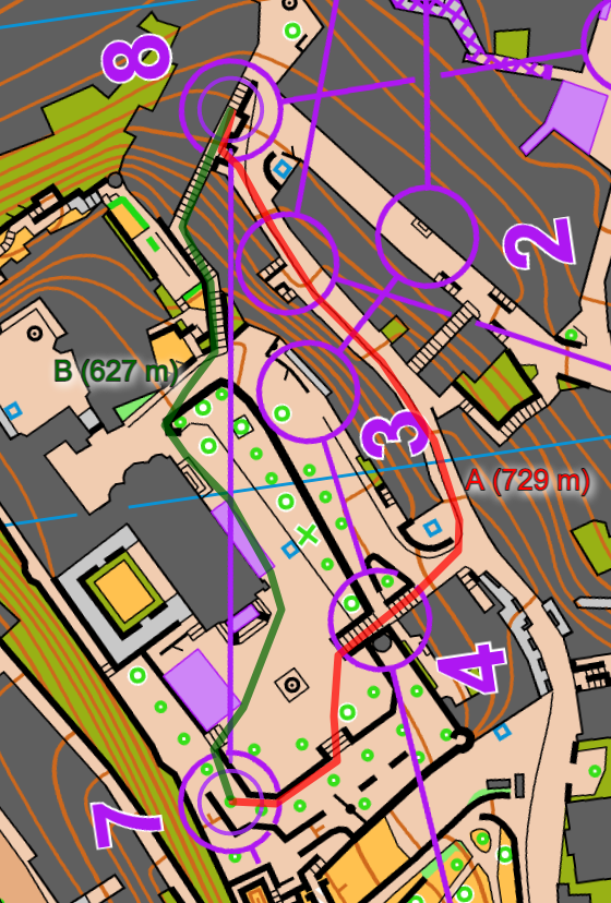
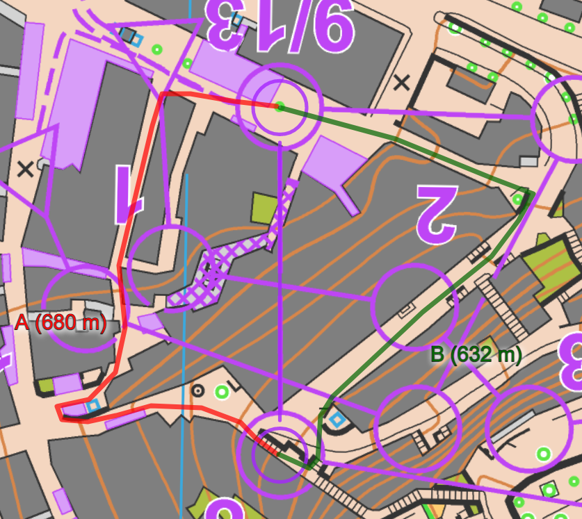
Below is one of the decisive legs from the semifinals were right (green) is significantly faster.
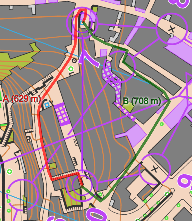


The KO Sprint was a real step up from thursdays pure running competition in the relays. Here we had what sprint orienteering is supposed to be about – decisive and smart choices at high speed flipping the game. Maybe best illustrated by Andrine Benjaminsen when turning back from one of the last posts in her semifinal and running free on a longer route choice, letting her competitors crumble in the running both up and down a lot of stairs.
But I agree, the catastrophic TracTrac GPS does nothing to lift or explain the experience, rather the other way around – it turns the whole thing into total jibberish.
What I’m missing a little bit from yesterdays event is the quarter finals, haven’t even seen a map from that.
For example swedish Emma Bjessmo, after doing a sharp qualifier on friday, is supposed to have messed it all up from the second last control. From being in the lead there she ended up last, more than a minute behind at the goal…
I have GPS in my car which I use when I drive around unknown areas in the city. This device knows exactly in which street I am – not jumping around or sending me through buildings. Even the navigation app on my mobile phone works fine when I am driving. What is the problem in orienteering? Is it the GPS positioning or the quality of the mobile network to get the data back to the computer in the finish area? Or is it a price/performance issue? Or something else? Just curious …
@Sprinter: The main problem is the GPS positioning (there has been problems with the mobile network as well, but that is not that main issue). In these narrow alleys, your GPS in the car would probably have problems as well, especially when you want to deliver updated position every few seconds. The mobile phone might work better as there are some algorithms for improving local positioning in cities implemented in the mobile phone operating systems.
TracTrac has just implemented an algorithm were (as far as I understand from their published material) they try to improve the accuracy of GPS in cities by defining “allowed areas” for the GPS, and “snapping” the position from whatever the GPS reports to the closest “allowed area”, probably also with some restraint with regards to how fast the GPS-unit can move (although this is tricky in real-time when your algorithm starts leading you down the wrong alley). This seems to work quite well for some runners, while for others it works bad with big jumps and jerky behaviour of the dots representing the runners. This terrain was one of the most tricky you could have for this kind of technology, so not a good first trial for the system. In my opinion these jumps are worse than the GPS-dots moving through buildings, but that’s just my personal opinion. Anyway, I think you should not use GPS at all if the quality is so bad that it looks unprofessional. Then you should rather use pre-made animations, and if possible use a spotter to assign names to each route in the animation.
To achieve better GPS-accuracy in cities, dual frequency GPS-technology (using frequency bands L1 and L5, see some info in this article) is probably going to help. This technology is starting to come in mobile phones (but not properly used in software yet) and various GPS-units (Garmin has got it in one of their latest handheld, but not in watches yet), and there is also a low-cost chip available where the technology is implemented (e.g. from Broadcom). Also, TracTrac algorithms for correcting GPS-position should work well if the errors are small, so in terrain with wider streets it might work quite well. So there is some hope for the future (maybe even today it they take the chance using GPS again?).
Looking at ”raw” tracks in 2DReRun we see how difficult it is to adjust them automatically, at least in worst parts.
Thanks, Jan. Much appreciated.
I am still surprised that they decided to use GPS tracking in the KO sprint. They must have tested this in advance and seen the issues? Who decides this – the organizer, the broadcaster or IOF? We (the enthusiasts) know this, but a “normal viewer” will be totally confused – even if the TV commentators repeats again and again that “the is wrong”. It does not give a professional impression of the sport, I think.
But let’s hope for the future – as you say!
I also got some other comments – regarding the map shown on TV. It is too complicated for a “normal TV viewer” to understand. It should be more like a “Super-Mario” map …. Of course, the “family” would still have access to the normal map on the web.
Any usability testing been done here?
I think the main issue is that the (1) the GPS-tracking was not working well and (2) that the GPS-view was zoomed out so that you did not know what to focus on. I think the route choice animation previews could be possible to understand with good explanations. If you should do something differently, I think a mix of aerial photo and map as used at the start of the course preview would be the best option (I like that blending from map to aerial photo; it you have good aerial photo that can work very well, even with moving “dots” and in “3D”).
A testdrive of the TracTrac system beforehand on the actual KO Sprint area would give at hand they could pack up their bags without having a go at the actual competition.
Championships should not be a guinea pig for lousy tech solutions.
For years we have been waiting to use an algorithm to prevent buildings from being crossed during orienteering broadcasts. Now the algorithm has been used for the first (?) time and produces worse results than before.
The bad zigzag routes could also be seen in open terrain.
If you haven’t already, these measures might improve the situation:
– Use all 4 GNSS (BDS + GPS + GLONASS + Galileo).
– Use as many frequency bands as possible (L1, L2, L3, E1, …).
– Correction signals (possibly country-specific), i.e. known in Germany under the name SAPOS.
– Wearing the antenna on your head – nobody would want that, because then our stars would not only have a hump on their backs but also technology on their heads ;o) . Jokes aside – you could integrate two antennas in the carrier system on both shoulders. Then they would have a clearer view upwards.
– The intelligent algorithm also has reserves and cancels out some impossible situations before they are broadcast on TV.
The people of companies like TracTrac will definitely stay on the ball. The new chips, which contain all cool functions, are available cheaper than ever before, but first of all have to be financed if you need 100 or 1000 pieces, for example. But please organizers, do not test such a system during a live broadcast!
@Lutz: Yes, you need to (a) use data from several previous races as input for your algorithms for testing, and prove that it works flawlessly, and (b) you need a plan B to jump to immediately if you see that it doesn’t work as good in practise as during test runs (and even a plan C where you can use route animations in case there is no GPS-signal coming through at all). My feeling is that neither (a) nor (b) was in place in this case. But just blaming TracTrac is probably too easy here – I guess the money involved is far less than what it takes to actually develop a stable system with the required performance characteristics, but still ….
Another question, Jan
were I assume you may know the answer :)
I was watching the Individual Sprint today, and I noticed that the running time we see on TV either does not stop and/or is corrected at the finish line. Why is this? Isn’t there a photo cell at the finish line which should stop the time and give you the correct time immediately? Or is the running time we see on TV not actually coming from the official timing machine, but is generated separately for the TV graphics – and may therefore be different from the official time?
Do you know who did the timing, by the way? (I saw the Tissot banners, but this does not necessarily mean that Swiss Timing did it – even thought their HQ in Corgemont is close).
The problem is probably in the connection between the official timing system and the TV graphics software (that has been the problem sometimes before at least), although I don’t know for sure in this case.
Thanks again, Jan
I have seen this several times (different sports) – if the timing provider uses a separate system (PC) to generate the running time for TV (time not taken not from the actual timer). Even if you sync the different systems before the event you often end up with inconsistencies. Sometimes you can see it clearly when TV shows a slow motion of the finish – the 10th and 100th actually go backwards. I have worked with Swiss Timing, and they are very strict on this. The time on TV has to come from the official timer.
Today there was a lot of corrections to the finish time. Not good marketing for the timing provider, I think – but they did not show their logo …
Sprinter, the timing was definitely not done by Tissot or SwissTiming, they don’t do orienteering (or at most subcontract others to do it, for example at TheWorldGames or Universiade). Judging by the pics I saw on stream and social feeds, the actual timing was done by a team called picoTiming, they’ve been doing it for the IOF top-level events in Switzerland for many years now.
Judging from previous events I assume picoTiming does not “publish” a running time to TV graphics while the athlete is still running, they only give official time when it has stopped. Therefore TV graphics needs to generate running time themselves and this might lead to (slight) adjustment after finish crossing.
In fact this topic opens up another can of worms regarding the options that the IOF rules provide regarding timing. The IOF rule 23.5 offers the choice of four different options, and it so happens that the one with least effort for the organiser (and thus frequently chosen) is timing by transponder, carried by athlete (read: “SIAC” or “emiTag”). But from a TV graphics point of view this is a bit of a nightmare, because this means there’s a box next to the finish broadcasting a timestamp to a rubber mat, and the transponder crossing the line “chooses” the timestamp that it “feels” fits to the line-crossing (by measurement of radio field strength for example), and then transmits that time back to a receiver which passes it to the TV graphics. This means quite a bit of intransparent “black box” effect regarding the “point of timing” and also introduces a delay until the official time reaches the graphics – thus you sometimes have the “time jumps back” effect.
GPS tracking has never been good for sprint, and the narrow streets of Neufchatel are very bad to get quality tracking.
But, for me it seems that Tractrac tracking systems tends to deliver shitty quality trackings and which are far worse than what GPS-seuranta usually delivers.
Even on the mixte relay or on first part of the sprint with more opened areas GPS quality is very poor.
And I made also the same observation on previous event, city or even forest orienteering…
You can also add to that, the software interface which is better on GPS-seuranta.
Is there a partnership between IOF and Tractrac company?
At one point if IOF want to be acknowledged as a serious sports, we can’t accomodate with such poor quality tracking
MKG, I suggest you read https://orienteering.sport/partnership-between-tractrac-and-the-orienteering-world-cup-2021/ (I hope links are allowed here). For many years, the Swiss organisers have been very successfully using GPS-seuranta, now it feels like the IOF forced TracTrac on them. (Some will remember that the WCF in China used TracTrac too, criticism after that event was quashed with “ah, but the networks and firewalls in China were really bad”).
Kyburtz vs the others on 8-9 pretty much proves that downhill stairs lose a lot of time compared to downhill road: He ran 100m longer but half as many stair steps and gained time.
When I heard about the tracking improvement from TracTrac, I was really excited. It is a pity that it did not work now. I heard it from Switzerland. They tested the tracking during a training. The results of that test looked quite good actually.
I have no background information, but I have the feeling that TracTrac tries to detect the route a runner has chosen and maps the raw points to that predefined route. This leads to strange speed variations along the route. Moreover, all deviations from these predefined routes (unexpected choices, wrong turns …) are lost. These properties of the method are not good for an in-depth analysis.
Some months ago I invested an afternoon in implementing a method that uses the impassable objects from an OCAD file to improve an inaccurate track from GNSS watches. I just used a simple particle filter with some measures that stop the particles from moving through buildings or walls. I tested the method on several tracks from different runners. This worked quite well, but already showed some limitations. If, for instance, the positions estimated by the watch jump around, then the improved track will also jump around or will at least not represent the real speed of the runner. This is similar to the TracTrac issue that I mentioned above. The advantage of my approach is that there are no predefined routes.
I hope to find some time to work again on that idea. I think that using a chip with Galileo E5 and GPS L5 could help due to their better multipath properties, especially when we have access to the pseudorange and Doppler measurements. My plan is to track a Sprint training with my smartphone (a lot of current smartphones have incredible GNSS functionalities) and use the observations directly to estimate the position in the allowed areas of the map. I think that this could work quite well.
If anyone here has also worked on this problem, or would like to exchange ideas, just leave a comment.
@Axel: Thanks for interesting comment. I think TracTrac’s solution is actually very similar to yours (but without having in-depth knowledge), i.e. I don’t think they use pre-defined routes, but rather the concept of “forbidden areas”; if the GPS reports a “forbidden position” it chooses the “closest logical place” using some “smart” method (or in TracTrac’s case it looks like the method isn’t that smart yet). E.g. it doesn’t look like it uses any “maximum speed” constraint as the GPS-position is allowed to jump from one side of the building and back in speeds of >100 km/h. Of course, when working in real-time such a constraint is tricky to implement as you might actually be on the other side of the building than what you first estimate, and then you somehow have to “move” the estimate to the other side of the building. However, at that time the best approach would be to re-calculate back in time and move the old track to a more probable track (with physically possible speed) instead of only updating the new position and not caring about the previous error.
The main problem, however, is that the raw GPS-data from the Knock-Out Sprint was really lousy for some runners. In 2DRerun you find the raw GPS-signals (before correction) – if you look at the final men here http://3drerun.worldofo.com/2d/?server=em.club.tractrac.com&eventid=6ab2de10-54c3-0139-b02a-60a44ce903c3&liveid=ee826c90-923f-0139-27a2-60a44ce903c3 – you can see that the GPS-data is a lot worse than you would expect from a normal GPS-watch for some of the runners. E.g. for Kyburz it is really, really bad, and I can’t see any algorithm fixing that. For Fosser on the other hand it is quite good, and here I think at least a post-process algorithm could do very well (live might be more tricky, but if you accept fixing retrospectively when you see that the algorithm was wrong, then it might be good). If you are interested, I can provide you with the GPS-data from the Knock-Out Sprint Final if you want to run it through your algorithm – but of course you would also need the OCAD-file from the organizers.
I think the only option to get better results here is L1+L5 multifrequency and/or fusing GPS-data with IMU-data (although that is also a bit tricky) and/or using beacons to improve the accuracy (as used for indoor navigation). I did some testing in a Swiss town with the 10 Hz Catapult GPS that we use for detailed analysis in e.g. XC-skiing, and that was at least not good enough (on the other hand I don’t think they really use the IMU-data to improve the GPS-data there). BTW, I didn’t manage to get a lot better accuracy out of my smartphone, even if it has multifrequency GNSS-functionality implemented – please let me know if you get it to work (and which App you use for recording).
@Jan: I have looked at the raw tracks in 2DRerun. I think you are right. If a track looks like that of M. Kyburz or A. Heimdal, then it is too late for an improvement. Even by relaxing the real-time requirements (for GPS tracking a small delay is acceptable I think, maybe 5-10 s or even more?) and using information “from the future”, there is no way to reconstruct the trajectory. Things have gone wrong earlier in the processing chain. If I find the time in the next weeks I might give it a try and see if I can reach a robust improvement with the better tracks from that competition.
The accuracy of GNSS is definitely limited in urban environments, especially when using cheap trackers with low-quality antennas. Using IMU data could help, indeed. I have seen impressive results with foot-mounted IMUs and map data integration (and no GNSS). The short periods that the foot is stationary during the step and the constraints from the map seem to be enough to limit the drift. Radio controls could be used in orienteering to get absolute position updates, which could be fused with the IMU and the map (at the server side). When somebody is punching the control he is close to the control location. That’s just an idea. I don’t know if this would be feasible.
Dual-frequency data might help, however more because of the added redundancy than because of the possibility to estimate or eliminate the ionospheric delays. These are not the problem we are dealing with in the city. The errors are dominated by the influence of the non-line-of-sight signals (multipath) and the degraded geometry of the positioning problem due to the signal obstructions.
I have experience with processing raw GNSS data from dual-frequency smartphones and designing dedicated algorithms, but I don’t know about the performance of available apps. There are some that should also exploit the carrier phase information (if your phone provides it), e.g. 3PGo from Spaceopal or PPP WizLite from CNES.
Coming to this (very) late, but I thought it was worth noting that most phones will lean heavily on RF (i.e. what wi-fi and/or Bluetooth access points can I see and how strong are the signals?) plus the Google Geolocation API or similar to determine position in an urban environment, rather than pure GPS. It would have been interesting to compare the performance of TracTrac’s GPS units for live geolocation with an cheap, off-the-shelf Android handset strapped to a runner’s back.
I found the link to the tracking test I mentioned: https://live.tractrac.com/viewer/index.html?target=https://em.event.tractrac.com/events/723a1040-07c5-0139-afec-60a44ce903c3/races/9b7055d0-0944-0139-bfd9-60a44ce903c3.json&showAlsoRawPositions=true
Unfortunately I cannot see the corrected tracks anymore. However you can see some predefined routes on the map. An example is shown in this video an it works in this example: https://www.youtube.com/watch?v=WLQL1vNFMOQ
Wow, Axel, that is a rather superb find. Looking at the link using browser development tools makes for some extremely interesting findings. The track correction seems to happen browser-side, not server-side. The original map (PNG) is there and a “route network” (KMZ) of permitted routes overlayed. Additional there seems to be a file that contains information about classes of terrain (it’s binary, but there are some strings labels “wood, forest, grass, park” etc.). And there’s over a megabyte of JS code that I haven’t even started to wrap my head around yet.
Anyhow, another idea from your link alone: possibly adding “&showAlsoRawPositions=true” to the tracking link would have partially saved the day at EOC by deactivating the not-yet-ready track correction?
Where are maps of quarter final?
I don’t have found them
Thx
Me neither, and that’s a pity. Because there was quite some action going on with some good runners falling out of the competition through decisive mistakes…
I have not found them either, unfortunately. It looks like the organizers have let IOF have the responsibility to post all maps/courses/results etc., and that IOF has not put focus on the quarterfinals as there was no TV.
Do you have Iof’s email address?
I can ask him about the final/4 maps.
Was it the same area as final/2 and final?
And I wish to propose for all big events:
1. Runners go to quarantaine, 2. close the door, 3. Iof publish maps.
Thx
If nothing else in this matter, their official mail contact is this: iof@orienteering.sport
Dear all, the quarter maps can be found here. Thanks to Sevä and Gümsi for the link.
https://archive.o-worldcup.ch/2021/05/25/infos-2021/