 World of O News

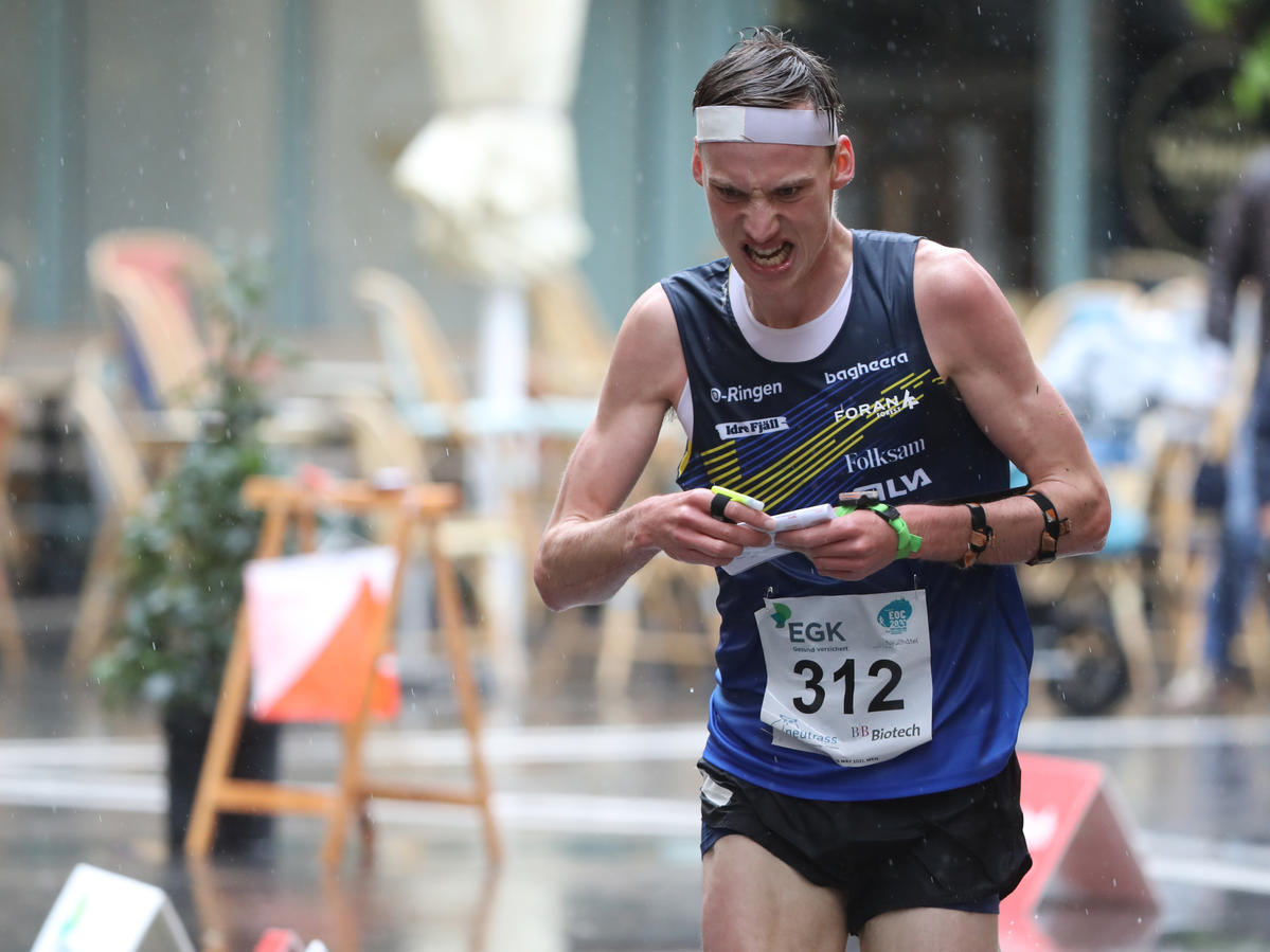
Double gold for Sweden with Tove Alexandersson and Emil Svensk in today’s European Orienteering Championships (EOC) Sprint.
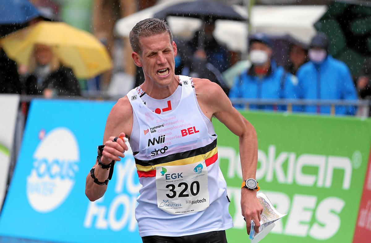
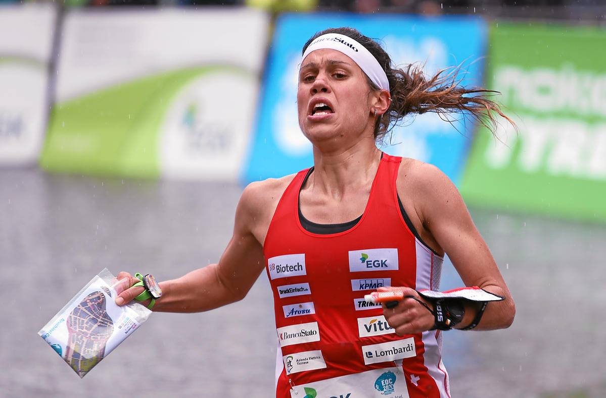
In the women’s class Alexandersson won ahead of two Swiss runners – Elena Roos and Simona Aebersold. In the men’s class Yannick Michiels (Belgium) took silver ahead of Gustav Bergman (Sweden) and Kasper Fosser (Norway) in shared bronze position.
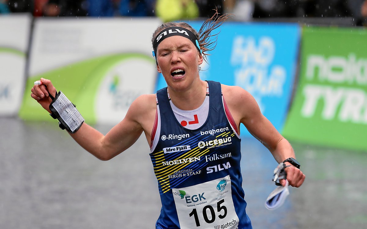
The winner in the women’s class Tove Alexandersson needs no introduction, but the men’s winner Emil Svensk has been living in the shadows of the other Swedish stars the last years, even if he has been part of the best orienteers in the world since his 10th place at World Orienteering Championships (WOC) sprint back in 2016. He also finished 6th at WOC Sprint in 2018 and was very close to the medals with a 4th place at WOC Middle back in Norway in 2019. With three World Cup 3rd places, this was the Swedes first visit at the very top of the podium.
For Yannick Michiels and Elena Roos this was also a very special day – after finishing in the Top 6 many times in EOC and World Orienteering Championships (WOC), they each finally got their individual medals today.
SPAS Analysis
Follow these links to a SPAS-analysis of EOC Sprint Men and EOC Sprint Women. All starting competitors are asked to enter their chosen route in the analysis. Until competitors have entered their routes, you can only see split times along with possible route choices for each leg.
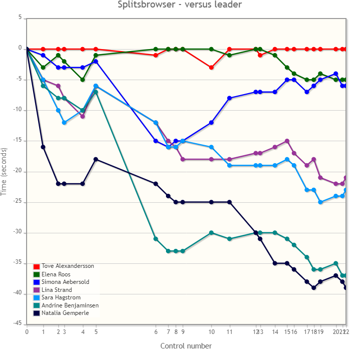
Race analysis women: Decisive long leg
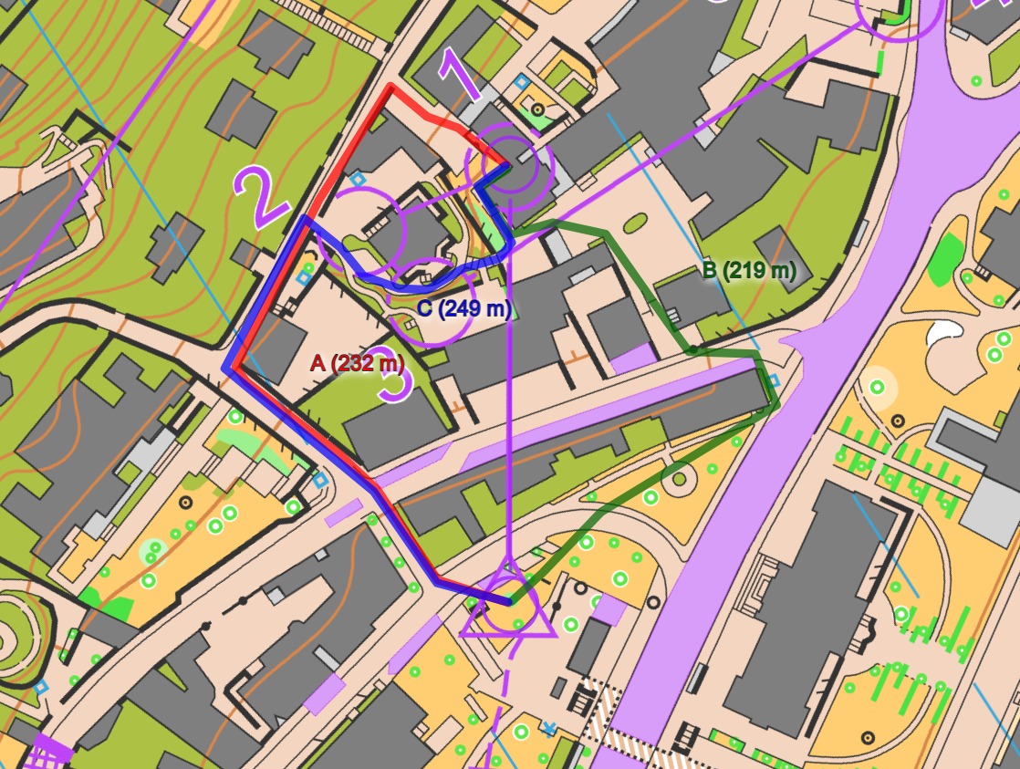
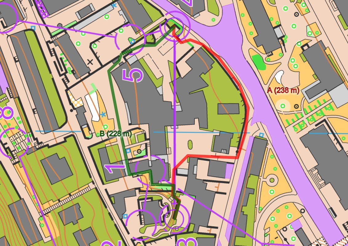
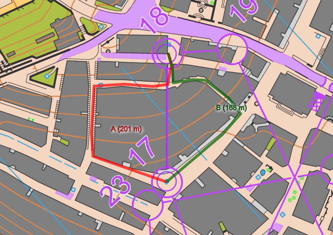
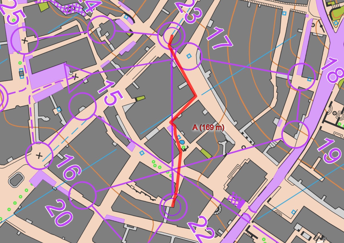
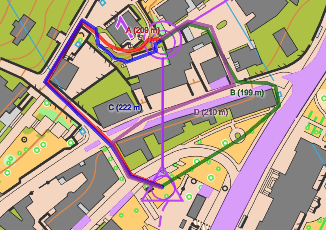
As you can see from the split time visualization below, the race was practically decided at the long leg to control 6 (see SPAS leg 6 for split times and route alternatives) where Alexandersson and Roos took the best choice (running around to the left) whereas several of the other top runners ran the upper route which was significantly slower. Aebersold seemed to have the best speed, but the time loss on the long leg to control 6 was too much to catch up.
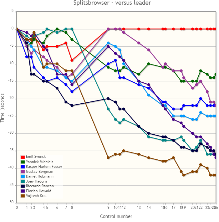
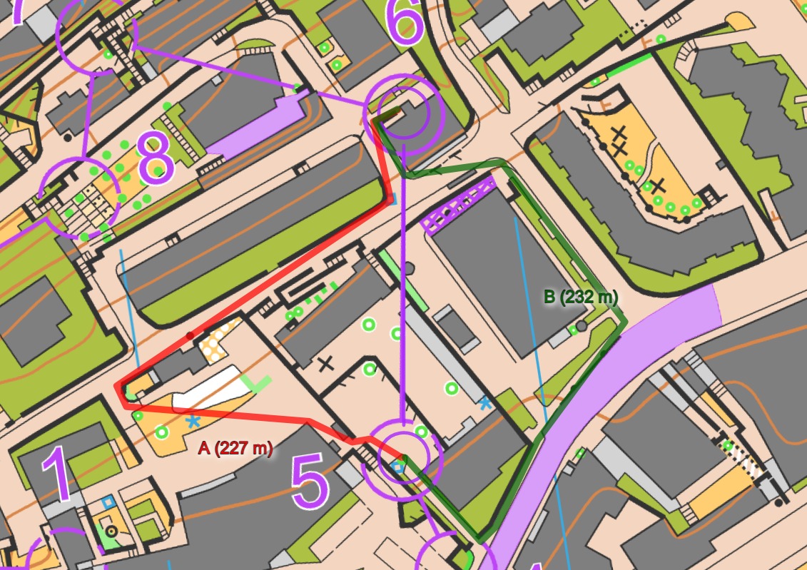
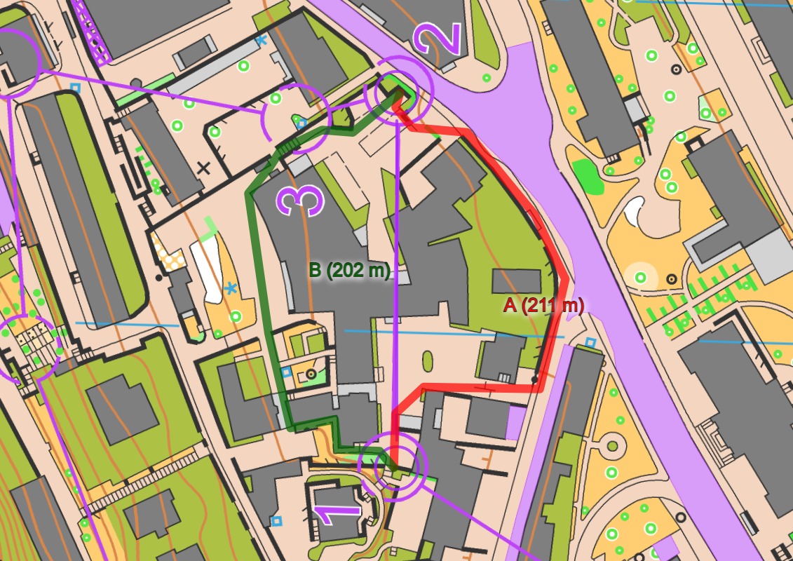
Race analysis men: Svensk with highest speed
In the men’s race the race was also mostly decided by the same long leg, which the men had to control 9 (see SPAS here). Bergman ran a fantastic time on this leg, but also Svensk, Fosser, Howald and Hubmann took the best route on this leg. Michiels took the wrong route here (running up), but due to his high speed still managed to stay in the battle for the medals – finally taking the second place. Svensk and Michiels simply had higher speed than the others today – which seems to be why they took the two top places. Some have speculated that the reason may partly because several of the other top runners had tough Knock-Out Sprint races in their legs from yesterday (Kyburz, Hadorn, Fosser, Rancan), while Svensk skipped the Knock-Out Sprint to rest ahead of the individual Sprint and Michiels missed the cut in the Quarter-finals. This might be part of the explanation – maybe the Knock-Out Sprint should be organized the last day in a later championships?
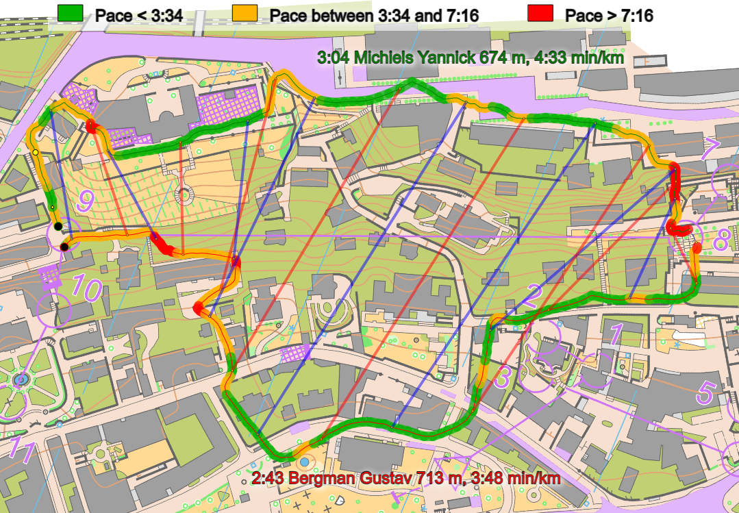
GPS-tracking coupled with official split times shows a clear picture of how decisive the leg to control 9 was:

Maps and GPS-tracking
See below for maps men (upper) and women (lower). GPS-tracking is available fra TracTrac. Below there is a separate section where you can study the course with route choice alternatives leg by leg.
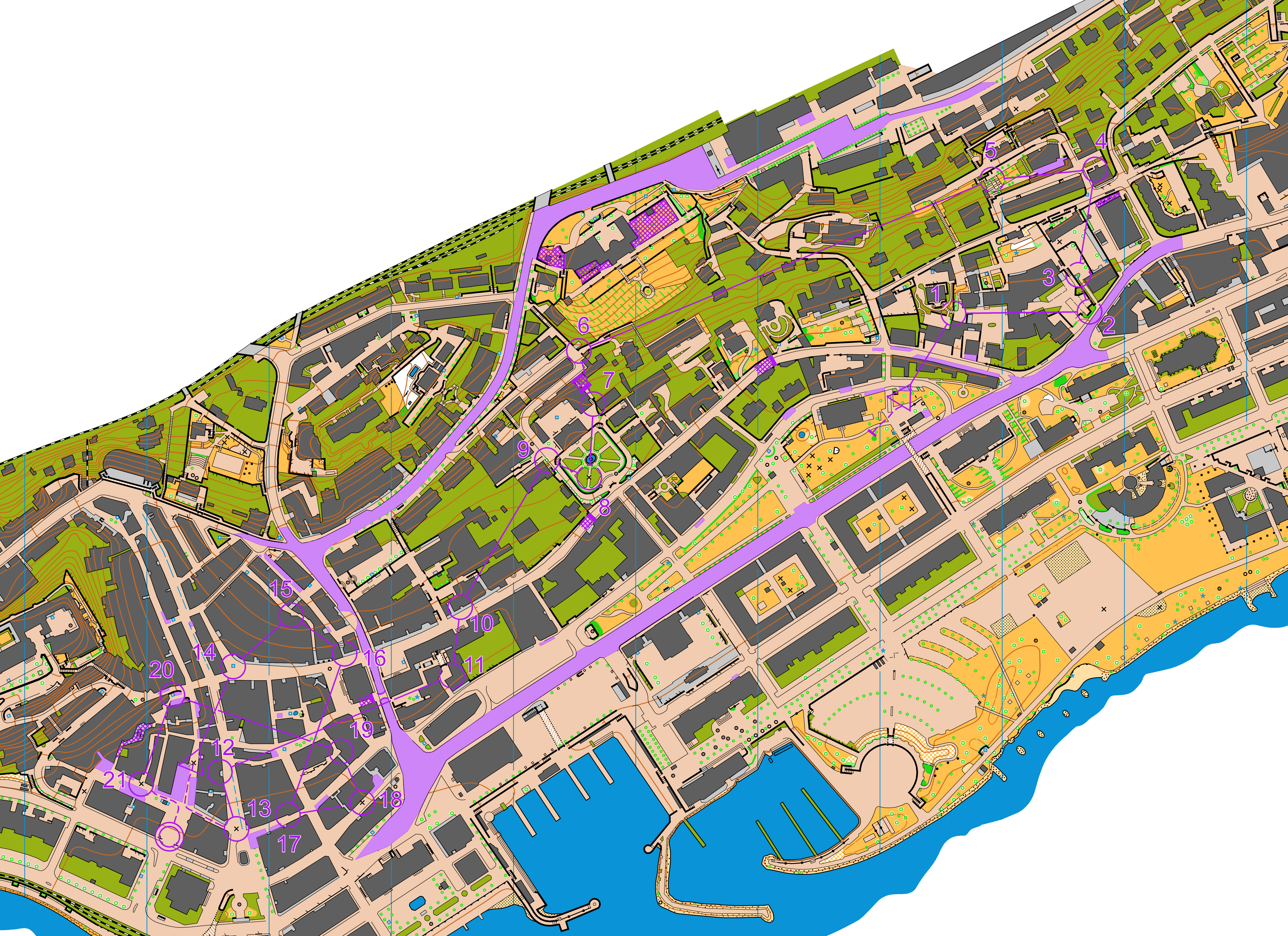
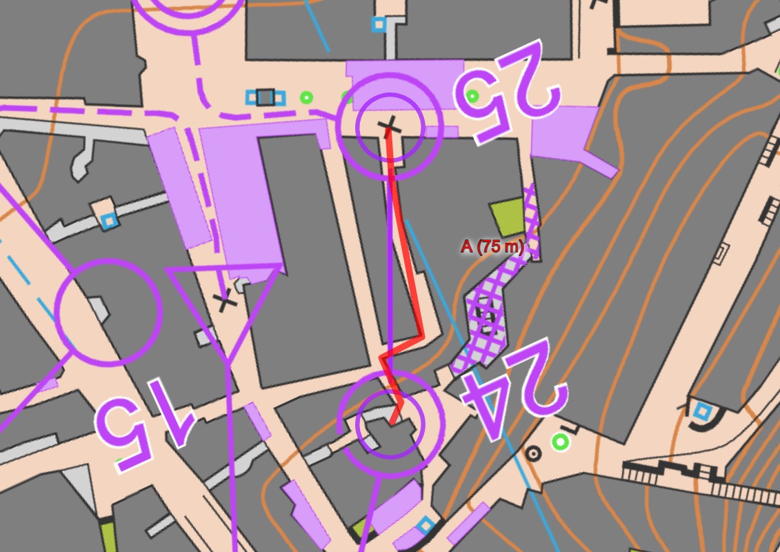
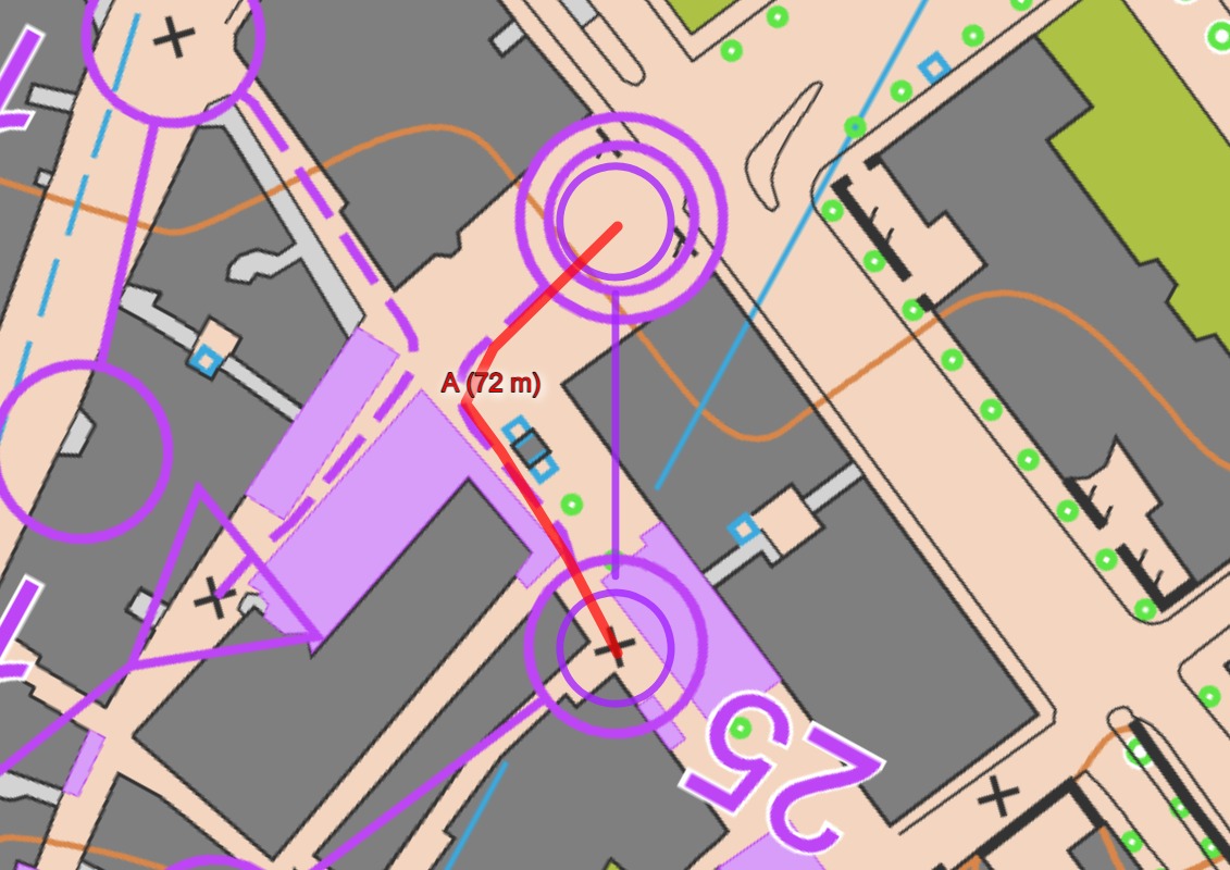
Legs & route lengths (men)


Legs & route lengths (legs that are different for women)

Results
Men
| 1. | Emil Svensk | Sweden | 16:06 | (+0:00) |
| 2. | Yannick Michiels | Belgium | 16:19 | (+0:13) |
| 3. | Kasper Harlem Fosser | Norway | 16:28 | (+0:22) |
| 3. | Gustav Bergman | Sweden | 16:28 | (+0:22) |
| 5. | Daniel Hubmann | Switzerland | 16:31 | (+0:25) |
| 6. | Joey Hadorn | Switzerland | 16:42 | (+0:36) |
| 6. | Riccardo Rancan | Switzerland | 16:42 | (+0:36) |
| 8. | Florian Howald | Switzerland | 16:43 | (+0:37) |
| 9. | Vojtech Kral | Czech Republic | 16:48 | (+0:42) |
| 10. | Martin Hubmann | Switzerland | 16:59 | (+0:53) |
| 11. | Matthias Kyburz | Switzerland | 17:00 | (+0:54) |
| 12. | Timo Suter | Switzerland | 17:03 | (+0:57) |
| 13. | Tim Robertson | New Zealand | 17:04 | (+0:58) |
| 13. | Maxime Rauturier | France | 17:04 | (+0:58) |
| 13. | Algirdas Bartkevicius | Lithuania | 17:04 | (+0:58) |
| 16. | Soren Thrane Odum | Denmark | 17:06 | (+1:00) |
| 17. | Axel Granqvist | Sweden | 17:07 | (+1:01) |
| 18. | Lucas Basset | France | 17:08 | (+1:02) |
| 18. | Isac von Krusenstierna | Sweden | 17:08 | (+1:02) |
| 20. | Gaute Steiwer | Norway | 17:09 | (+1:03) |
Women
| 1. | Tove Alexandersson | Sweden | 16:10 | (+0:00) |
| 2. | Elena Roos | Switzerland | 16:15 | (+0:05) |
| 3. | Simona Aebersold | Switzerland | 16:16 | (+0:06) |
| 4. | Lina Strand | Sweden | 16:31 | (+0:21) |
| 5. | Sara Hagstrom | Sweden | 16:33 | (+0:23) |
| 6. | Andrine Benjaminsen | Norway | 16:47 | (+0:37) |
| 7. | Natalia Gemperle | Russian Federation | 16:49 | (+0:39) |
| 8. | Hanna Lundberg | Sweden | 16:59 | (+0:49) |
| 9. | Karolin Ohlsson | Sweden | 17:25 | (+1:15) |
| 10. | Sandra Grosberga | Latvia | 17:26 | (+1:16) |
| 11. | Emma Bjessmo | Sweden | 17:28 | (+1:18) |
| 12. | Tereza Janosikova | Czech Republic | 17:29 | (+1:19) |
| 13. | Vilma von Krusenstierna | Sweden | 17:30 | (+1:20) |
| 14. | Maija Sianoja | Finland | 17:34 | (+1:24) |
| 15. | Sabine Hauswirth | Switzerland | 17:43 | (+1:33) |
| 16. | Victoria Haestad Bjornstad | Norway | 17:52 | (+1:42) |
| 17. | Paula Gross | Switzerland | 17:53 | (+1:43) |
| 17. | Megan Carter Davies | Great Britain | 17:53 | (+1:43) |
| 19. | Martina Ruch | Switzerland | 17:56 | (+1:46) |
| 19. | Aleksandra Hornik | Poland | 17:56 | (+1:46) |


Felt like Hadorn and Kyburz fighting all the way for the medals yesterday costed too much for having a real chance today. With that in mind – very impressive by Kasper Fosser who also had a long day yesterday…
There is a typo in the introduction as Yannick took the silver medal.
@Christian: Tx, fixed.
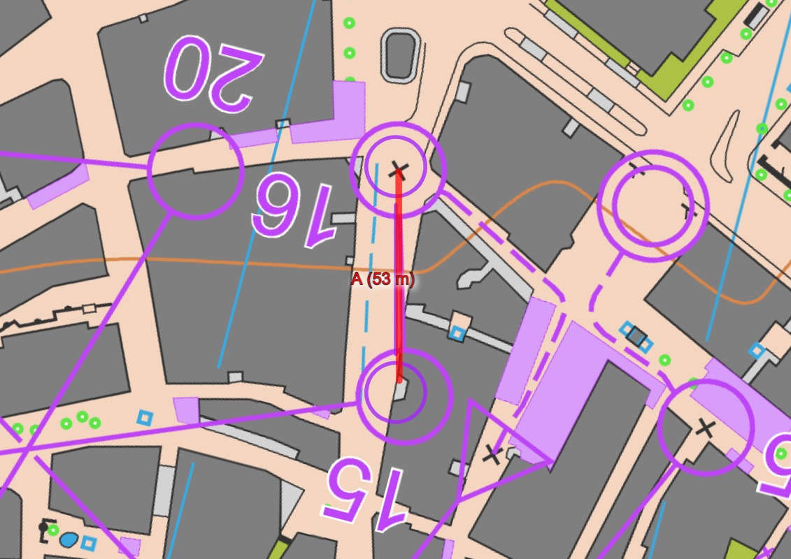
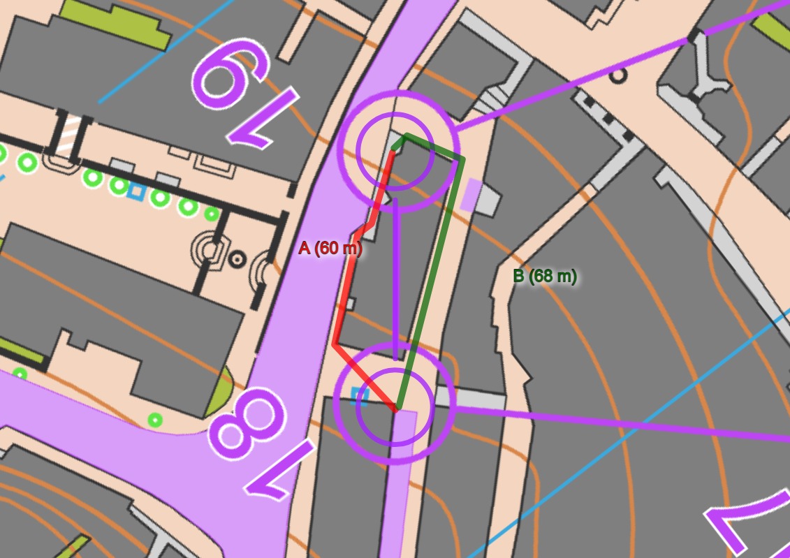
The best route to men’s 14 (as well as 15, and same for women) is going under a bridge. ISSprOM-19 clearly states: “If underpasses under bridges are to be used in a competition, they *shall* be emphasized with the symbol Crossing point (710.1) or Crossing section (710.2).” How come IOF does not control this?
@hati: that was not a bridge but a situation with two levels. Because that can’t be mapped unambiguously the situation was documented with photos and map in bulletin 4. The athletes were prepared for this.
@Gante: Aha, if it was mentioned in the bulletin, then I retract my question. The bulletin can override any rules or signs. Great that they did it.
(Though, I disagree with your words that it is not a bridge. Both signs 512.1 Bridge and 512. Underpass or tunnel are used here.)
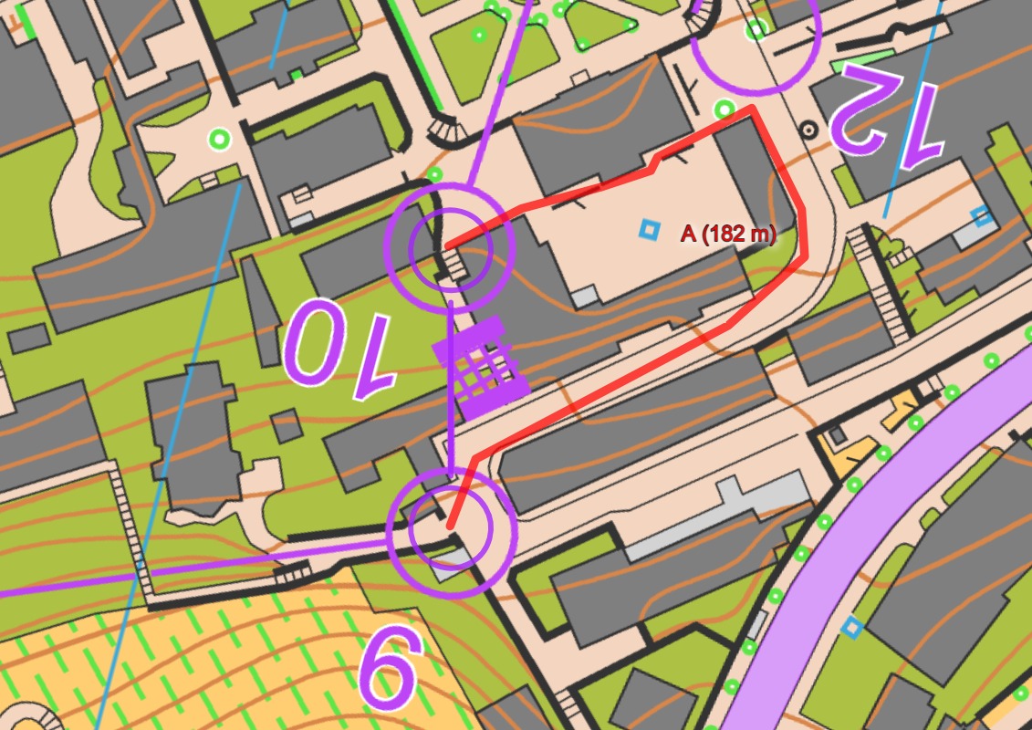
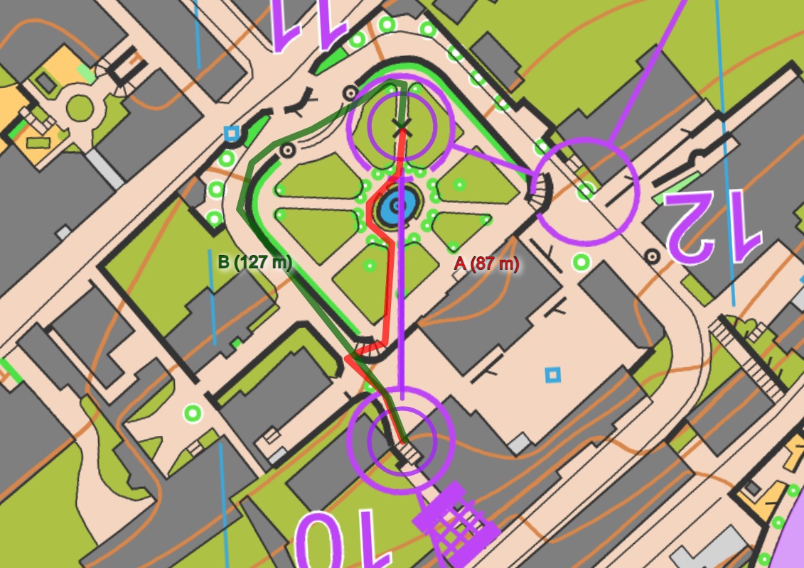
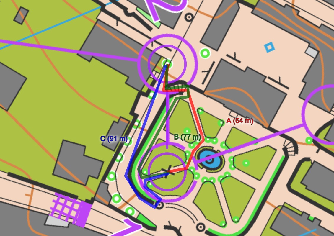
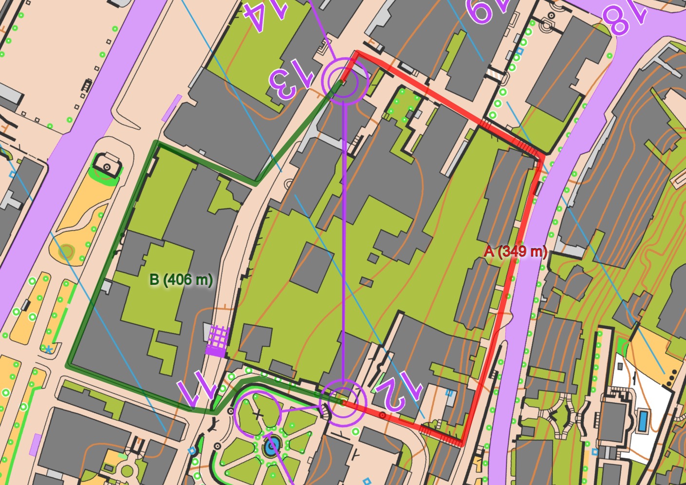
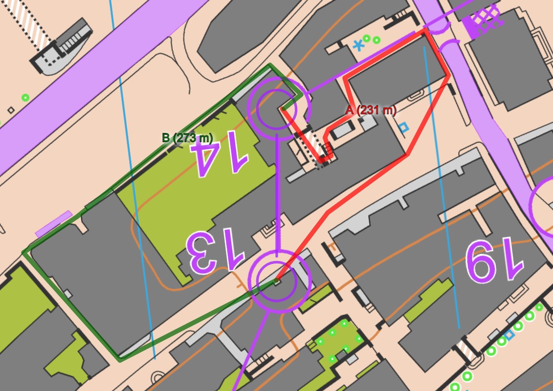
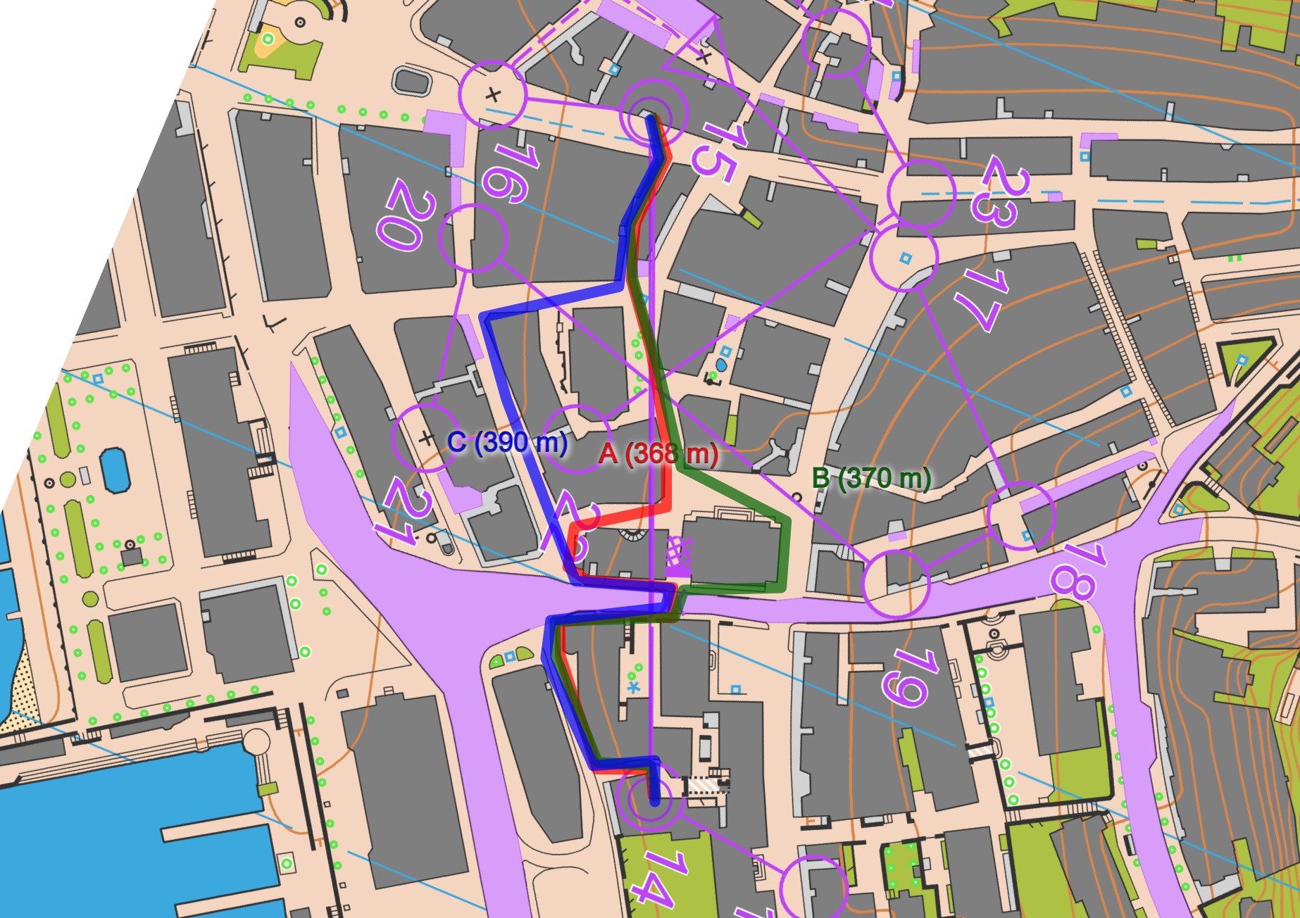
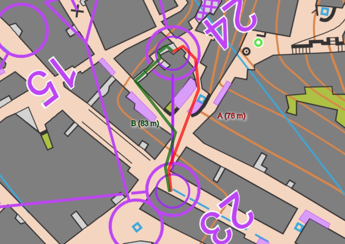
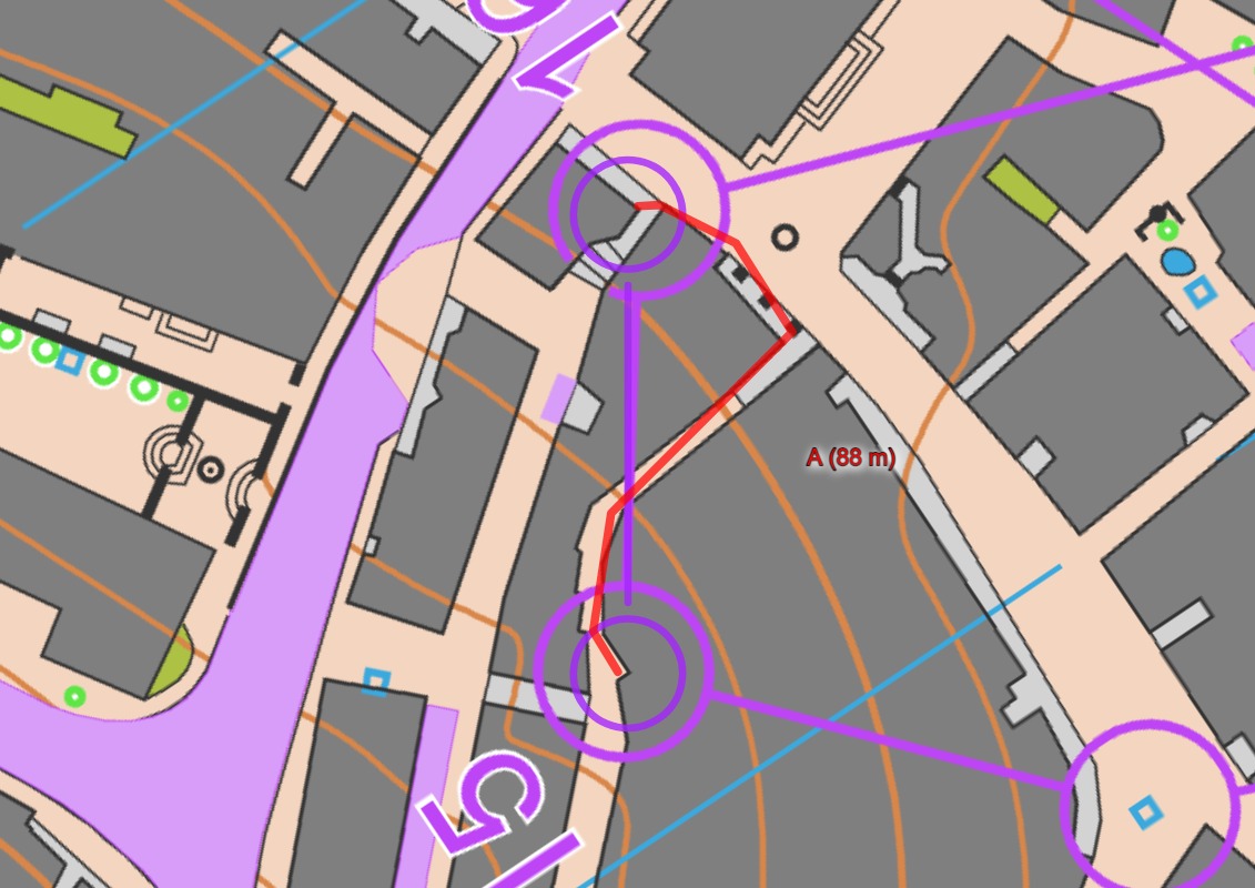
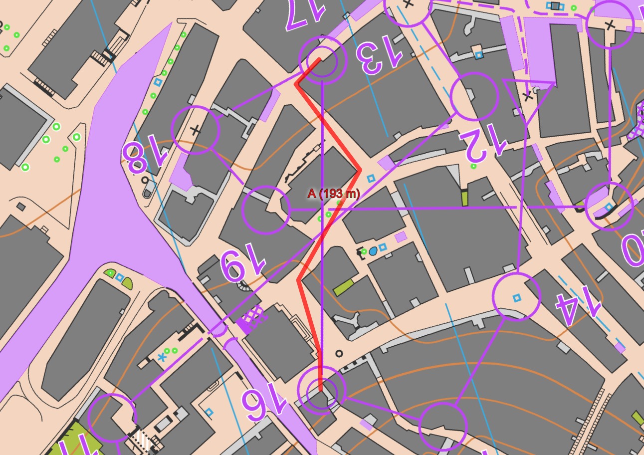
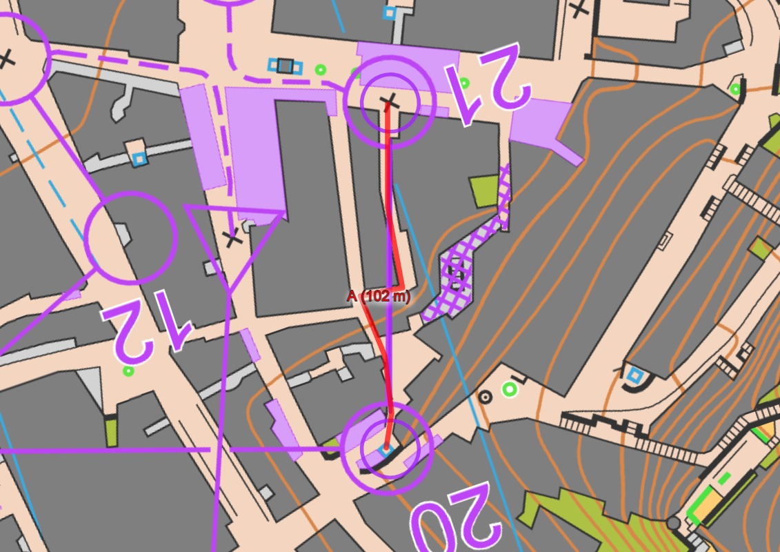
The long leg (5-6 for the women and 8-9 for the men) was decisive for the end results in both classes. The lower route choice (A) seems to be around 15-20 seconds faster than the upper route choice (B) when adjusting for differences in the running speed. Such a difference (10%) is very much in a sprint and should be quite easy to spot from the map, at least if you are sitting in the sofa and have as much time as you want. I have been studying these routechoices for a while now and I don’t understand how it is possible to see this difference from the map. A is slightly longer than B – 730 compared to 725 meters. Both route choices have the same climb – 10 contours. There are about the same amount of upphill and downhill stairs, but the upphill stairs on B seems to be somewhat steeper than on A. B has some more steep corners, but not at all enough to explain the difference of 15-20 seconds, it could maybe explain 2-3 seconds. Technically there are not any larger challenges on either of the route choices that should slow down an elite runner when executing his/her route.
The only reason I could guess for this big difference is that if you choose the upper route choice (B) you get the climb in the beginning of the leg, and you are coming to the flat part with tired legs full of lactate. If you choose the lower rooute choice (A) you run the flat part with fresh legs and are nearly at the control when your legs get tired. If this theory is valid then it should be possible to see the effect of this on the next leg (here those who chose A should be more tired), but it is not possible to see anything like this from the splittimes.
So my question is: How is it possible to see from the map that the lower route choice is 15-20 seconds (10%) faster than the upper?
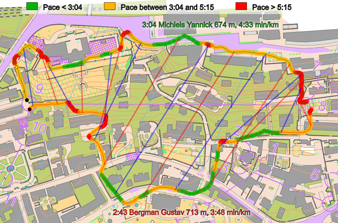
@Leif: Thanks for interesting thoughts and analysis! My thoughts: When studying the map ahead of the race it was at least very clear to me that left had to be faster, but I would have estimated 10 s and not 15-20 (looks like it is actually 20+ in the men’s and a bit less in the women’s?). I think you lose a lot of time due to all the corners in narrow alleys/roads – I counted more than 15 to the right and 6-7 left (the corners on the big roads do not slow you down that much). Generally you also lose time when running on a narrow alley compared to a wide road, especially when you have to read the map, it should be at least a few percent slower, when map reading even 5-10% slower in a really narrow alley. And there is also more mapreading to the right. I am not at all surprised by a 10 s difference from my desk, but in competition it is tricky. When I was drawing the route in 2DRerun for the analysis, I took left, then noticed the barrier, and took further around to the left. I noticed so late that I could not change my route to right, but I think in a competition I would have been reading a bit more ahead (but maybe not enough), and maybe switched to right due to the barrier (if I wouldn’t have time to fully read right). So a nice challenge by the course setter. On the other hand, I think this leg was a bit too decisive for the end result, and the courses could have benefited from some more route choice challenges towards the end.
@Jan: I agree with you that you loose more time around corners in narrow alleys than on wide roads. When I count the corners in the narrow alleys on both the route choices I find 5 on the lower route choice and 10 on the upper, so here you have a point. Maybe it could mean 5-10 seconds. I also agree that it is probably slower to run in a narrow alley than on a wider road, especially during map-reading. When I mesure the distance with narrow alleys or stairs on the two route choices I get about 150 meters for the lower route choice and about 70 for the upper. So this argument actually pulls in the opposite direction. The pavement along the forbidden road on the upper route choice I then don’t count as an “narrow alley” as you should have good overview over the pavement and road. But if this pavement was busy with people and the allowable part of the road was filled up with parked cars then this part would be slower.
@Leif: Based on the map, the upper part looks more “busy” with a quite narrow sidewalk, but might be wide enough. I tried to color the two routes with my impression about how “care-free” you can run based on what I see on the map, and I still think left looks a lot better. Also, there are really a lot of narrow corners, often mixed with stairs, on the right one. Anyway, this is mostly an academic discussion, but still interesting :-)
@Jan: Truly academic :-) But nice illustration! And with the split times in mind you must be right. But according to what you can read from the map I would have changed much of the blue dots to green, and then I think 20 seconds are much.
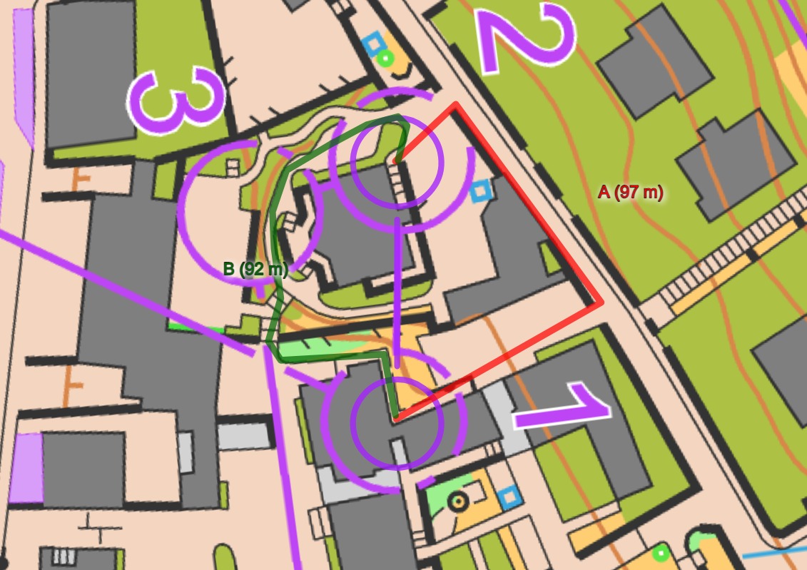
Even tho I’m close to the bottom of result list, I can tell you what tricked me with right (north) option :D
Faster guys were maybe more prepared, or it was even harder for them in higher speed?!
….and it’s transparent purple on competition map (not solid as on map you see on web). My decision to go right was based on fact that from beginning of the leg it was allowed to run on sidewalk (while road was forbidden), so I assumed it’s allowed all the way to 9. Of course, I was my mistake not looking at the leg as a whole, but I guess many did same mistake as me. Transparent purple didn’t help much as at first glance it didn’t suggest “attention! you shall not pass” :D
Once I came near entrance of the park, I saw tape on the floor/sidewalk and realized the problem and that I have to get in park and run around building. That confused me and I lost some extra seconds for rerouting myself and checking how to get out fast.
Some runners didn’t even see tape and run in forbidden (some being disq, some realized later and ran back, but losing lots of time (Groell from Austria lost 1min compared to me).
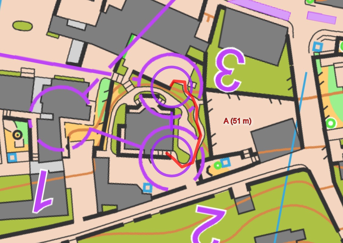
Another problem was planning ahead and why I only had quick glance at the route-choices. Beginning of the race and especially 6-7-8 was tough to run. It was up&down narrow slippery stairs, so there was no much chance to look at the map and plan ahead. I basically came to control 8 and stopped for 5sec to see what to do.
Also as Bernt said. Steep stairs up from 8 and steep stairs down to 9 were really slow.
Bernt O. MyrvoldMay 18, 2021 at 7:44
Could the clue to the big difference be the relatively steep decent at the end of route choice B? I cannot see any running down stairs at the other route choicves. It is not the climb that slows you as much as running down stairs. The TV pictures clearly showed runners troubling in the steep decent with narrow steps.
I agree with BOM here! If the weather had been nice, those down stairs would have been possible to run a lot faster, but it still does not explain the big difference, maybe 5+ seconds.
I rather think that when/if it is possible to do Jan’s classic compare graph, we’ll see that there is quite a lot of slightly downhill road running to the left, and that makes it possible to read the map while running at full/maximum flat speed.
I think we saw on the leg to the TV control after the park that running longer around left to avoid the staircase did not save any time: When you have to gain altitude, these runners will do that faster in a staircase than on most roads, but going downhill without any sharp corners they can run below 3 min/km.
Looks like it is possible to get something sensible out of the uncorrected GPS-data here. The first part of the leg, up the stairs, looks to be quite time-consuming on the right route. And it also looks slower on part of the flat.
I was told from a runner who ran the upper route choice that when coming up to the flat part, and just after the square area with trees, there was a bus station. The surface here was actually metal grating which was quite slippery and not so fast in the wet weather. Later, on the road in the park around the big house the surface was gravel which also slowed down the running compared with hard surface like asfalt. This is probably explains some of the reason for the lower speed on the flat part on the upper route choice.
However, as Matija Razum explains, another reason is probably that many of the runners choosing the upper route choice, hadn’t detected that it wasn’t allowed to run on the pavement along the main road all the way. When they understood this there was probably some hesitation before they found the way on the map through the park.
So the gravel areas were slower – do you think sprint maps should differentiate between asphalt and gravel?
Why were the OOB roads shown with the purple screen (714) not the cross hatch (709)?
From ISSprOM:
714 Temporary construction or closed area (A)
Obvious temporary constructions like platforms for spectators and speaker, closed area for spectators, outside restaurant areas, etc. shall be represented in plan shape.
I always thought this symbol should only be for where there is a temporary structure, or something like that. I would expect a normal road that has nothing else on it (like cafe tables or awing) to be shown as cross hatching (709)
Good question. Looks clearer on the competition map (I think this is the competition map), but still 714: http://karten.guedels.ch/show_map.php?user=remoruch&map=2887
I guess it doesn’t really matter but for the pale purple (714) I would expect there to be something there – not just open road. I guess part of the reason why course setters prefer to use 714 is because the cross hatching (709) is such a heavy symbol it obscures everything behind it and a large amount of 709 on the map would make the purple course symbols harder to see.
Are splits available somewhere?
http://obasen.orientering.se/winsplits/online/en/default.asp?page=classes&databaseId=74542
Thank you for an interesting discussion. I did a similar analysis as Leif earlier. When taking length and climb into effect right should be 1 s faster. When correcting for more turns etc left is indeed the best option, and runners taking right should rightfully lose time. But not more than 5-6 s. Or may be 8-10 s. The fact that runners tend to lose ca 10 s more than this must be due to a) slippery surface passing the bus station b) the gravel, and c) hesitation like Matija is explaining. My summary is still that at least 5 s probably 10 s of the time difference for the right option is not detectable from the map. This constitutes a large problem. In one way you could argue that this corresponds to a route choice being 15-30 s longer than it looks on a forest middle distance. So I, regretfully, still must conclude that this otherwise excellent sprint competition suffer from a too large luck-element. I am really happy that YM was beaten by a significant margin, and will cheer a bit extra for SA during WOC.