Today’s leg in Route to Christmas 2024 is taken from one of the nominations for Course of the Year 2024, the Norwegian Long championships organized in the Verdal-area north of Trondheim.
Make sure to check out Course of the Year 2024 and submit your nominations in the comment field – there are already around 30 nominated courses which you can see here.
With regards to the Norwegian Championships Long, this is was definitely an interesting course with some challenging leg. – “What all orienteering courses should aspire to be” is the statement that followed the nomination of the course for Route to Christmas. In particular, the long leg chosen for Route to Christmas is an interesting one where you have to consider climb versus length, factor in the runnability, and also make sure you actually understand how much climb there is on the various alternatives.
This is what the pre-race information said about the terrain:
Typical Trøndelag terrain, rugged with many marshes and slopes. The vegetation varies from completely open in the upper areas to somewhat denser vegetation in the lower parts. Most of the course runs through sparse coniferous forest. Runnability and visibility are mostly good, but some areas have tall heather that will demand greater physical effort from the runners. The marshes are generally relatively fast to cross, but heavy rainfall in recent weeks has made some sections significantly harder to traverse.
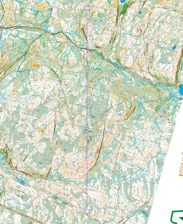
The leg is as usually first provided without routes – you may take a look at it and think about how you would attack this leg (if the image is too small, you may click on it to get it larger):
Location
You find other maps from the area in omaps.worldofo.com here. See also latest additions in 3DRerun from this area in order to learn more about this terrain type.
Webroute
Next you can draw your own route using the ‘Webroute’ below. Think through how you would attack this leg, and draw the route you would have made. Some comments about why you would choose a certain route are always nice for the other readers.
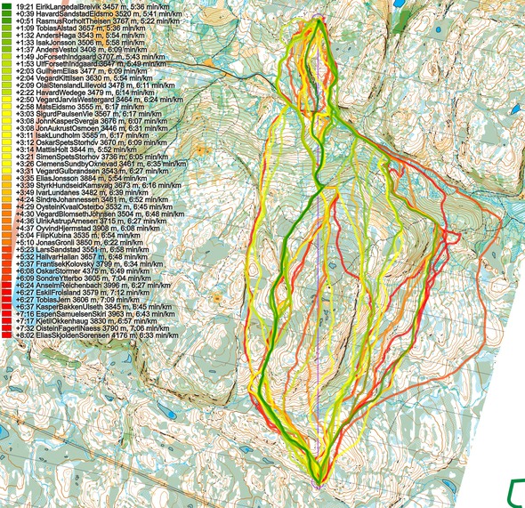
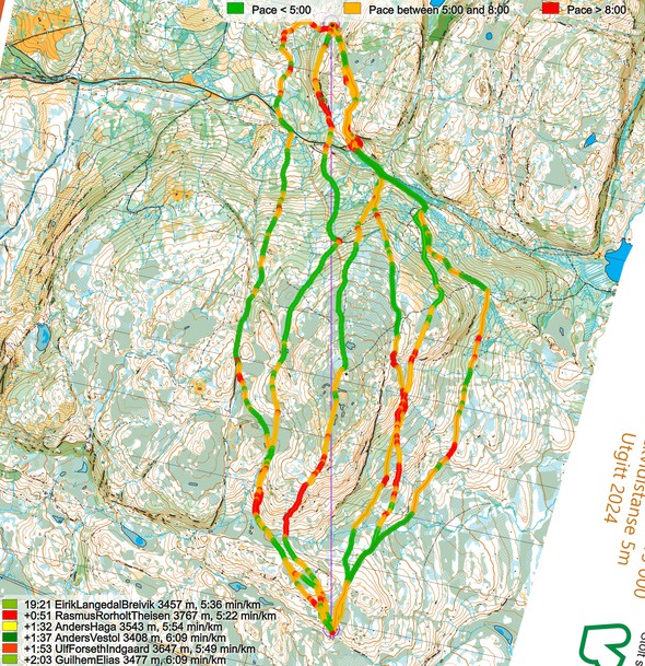
Then you can take a look at how the runners have solved this leg below. The routes are colored according to fastest split time on the leg, with the fastest routes in green and the slowest in red.
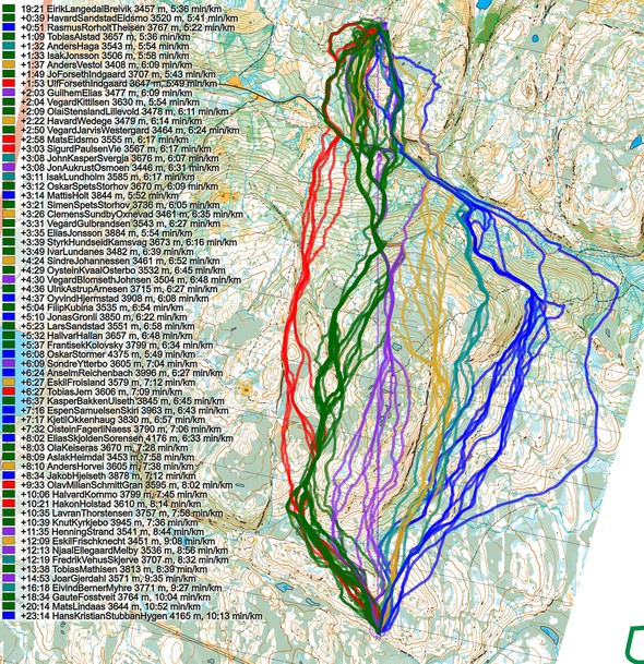
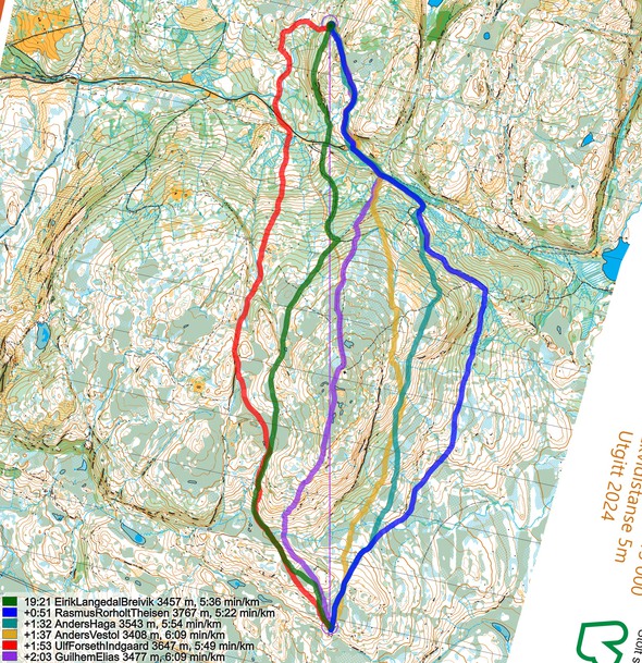
Below the routes are colored according to variant to give a clearer view of the how many runners chose each variant.
This looks quite complex to analyze today, so as a test I let chatGPT have a go at the analysis, feeding in the illustrations for the leg. This is what came out on the first (and only) try – not bad actually:
We see a wide spread of route choices with a few distinct patterns. At first glance, the overall picture shows multiple groups of runners heading out in different directions, but a closer look reveals that the fastest times cluster around a certain set of variants. These variants manage to keep running speed below 5:30 min/km for a good part of the route—key for a quick split time on this leg.
The variants that went slightly to the right seem slower, likely due to rougher ground or thicker vegetation in the hillside. Some runners who tried that direction show extended stretches above 6:00 min/km, which strongly indicates slow progress in that area. Interestingly, this does not appear to be caused by big climb differences, but rather by harder running conditions on the ground. Even areas that look runnable on the map might be full of low-visibility forest or uneven footing that forces runners to slow down, as we can see clearly on their pace plots.
Meanwhile, the more direct routes or those slightly left seem to allow runners to maintain a better speed, especially after the initial climb. These routes involve some extra climbing early on, but the advantage is that you hit more open or easily runnable ground after you crest the hill. Once on top, some of these runners manage consistent pace below 5:00 min/km, and no significant slow patches appear in their speed profiles. This suggests that even if you invest effort early, you get a clear payoff later in the form of faster running in more open terrain.
Road or marsh running does not look like a major factor here. While some runners did try swinging out to the road or using marshy areas to speed up, the difference in speed on these parts does not look large enough to offset the longer distance. The gains on easy running surfaces appear smaller than expected, probably because transitioning on and off these routes costs some time and concentration.
If we compare the fastest routes—those slightly to the left or mostly straight through manageable forest—they consistently end up 1–2 minutes faster than the right-side variants. The elevation profile supports this: although you pay for some height gain early, it sets you up for a smoother run later. The key seems to be maximizing time spent in terrain where you can hold at least sub-5:30 min/km pace, and that’s exactly what these top times achieved. In contrast, the right-side routes may look appealing on the map, but the pace data shows that they involve slow going in subtle but time-consuming conditions.
In summary, the analysis points to the more direct or slightly left routes as the best choices. Investing in some climb up front pays off, as the faster terrain after the climb lets you maintain good speed. Going right or trying to be too clever by picking “easier” ground looks tempting but does not deliver the speed you need. The data makes it clear: taking that direct or slightly left route and pushing through the early climb sets you up for a winning split on this leg.
—-
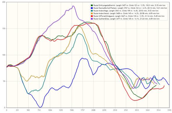
Not too bad from chatGPT, I would say – and as an added benefit it doesn’t have left/right problems. With regards to the analysis, I can add that I was surprised to see that trying to go around to the right (blue) to avoid climb actually gave you more climb than the left variants, in addition to a longer route (going even further around to the right gave you even more climb) – still good runners managed to run very good times here (3rd best was a blue alternative). Also, I agree with chatGPT that going slightly right to try to avoid the climb gives you somewhat poorer runnability in the hillside – in addition to some extra climb (rather than less climb) because you dip down before climbing up again. Finally, the straightest variant (purple) gives you a combination more climbing and a steeper climb (which is often less advantageous).
Density map
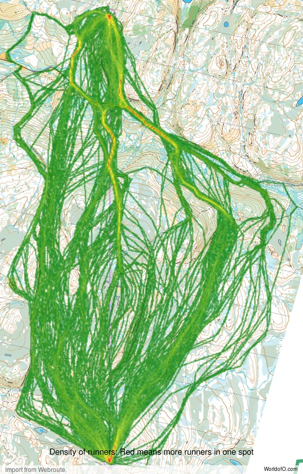
See below for a density map of some of the ones who have drawn their routes so far (available during the day when some readers have drawn their route).
Additional information
You find the complete map in omaps.worldofo.com at this location.
Route to Christmas series
The Route to Christmas series is a pre-Christmas tradition at World of O – giving the readers the opportunity to do one Route Choice Challenge each day from December 1st until December 24th. If you have got any good legs in GPSSeuranta, 3DRerun, Loggator or Livelox from 2024-competitions, or old forgotten ones which are still interesting, please email me the link at Jan@Kocbach.net, and I’ll consider including it in Route to Christmas if it looks good. Route to Christmas gets interesting due to YOUR contribute!
Not all legs are taken for the interesting routechoice alternatives – some are also taken because the map is interesting – or because it is not straightforward to see what to do on a certain leg. Any comments are welcome – especially if you ran the event chosen for todays leg!
 World of O News


Thanks for the Route to Christmas tradition, it’s now have been 15+ years of the Advent calendar for orienteering enthusiasts.
Today climbs and elevation profile seems a bit off, counted contours – to the place where blue, purple and green meet at the road:
purple is plus 80 meters
green is plus 40 meters
compared to the blue one.
Thanks a lot, Martins! I know the Google API does not give perfectly accurate elevation data, but it looked sensible with where there was up and down, and the highest lowest point on each route, so I took the change on including it. I’ll try to download LIDAR-data (as this is Norway I have it available) and make a comparison to understand how it is off. Great that you took the time to check this out!
I still think it is useful to see the elevation profiles to understand something about the elevation profiles, but I might have to remove the y-axis and the amount of climb in the legend in these elevation profiles going forward.
Hi!
Some runners are missing. Unfortunately not everyone uploaded to livelox. Here are top 10 on this leg:
Yngve S. 18.54 (without GPS, but said i ran to the right)
Kasper F. 18.57 (blue), including a 20-30 sec mistake
Eirik LB. 19.21 (green)
Sander A. 19.49 (green)
Håvard SE. 20.00 (green)
Magne D. 20.07 (blue)
Lukas L. 20.10 (green)
Rasmus RT. 20.12 (blue)
Tobias A. 20.30 (green)
Andreas S. 20.42 (green)
I think blue is equal to, or slightly faster than, green. I’m kind of a slow starter so I’m pretty sure I wouldn’t have been faster on the green route.
Thanks a lot, Rasmus, good additional insights there! I guess it may be more tricky to execute the blue one well, and that may be part of the reason why green looks better here?