Today’s leg in Route to Christmas 2024 is from a low-profile World Ranking competition in Estonia called Magaziin orienteerumismängud, organized by OK Kobras. Thanks a lot for the tip, Janis Tamuzs!
Here is Janis’ take on the terrain:
The terrain is typical for the Baltics – green and clearings are generally rather unpleasant, white has a good runnability and the marsh typically has high undergrowth, but it was not very wet on the nice autumn day of the competitions.
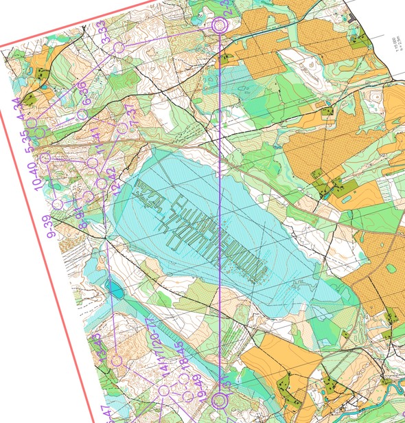
What would you do when faced with a leg like this? The leg is as usually first provided without routes – you may take a look at it and think about how you would attack this leg (if the image is too small, you may click on it to get it larger)
Location
You find other maps from the area in omaps.worldofo.com here. See also latest additions in 3DRerun from this area in order to learn more about this terrain type.
Webroute
Next you can draw your own route using the ‘Webroute’ below. Think through how you would attack this leg, and draw the route you would have made. Some comments about why you would choose a certain route are always nice for the other readers.
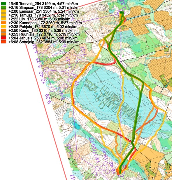
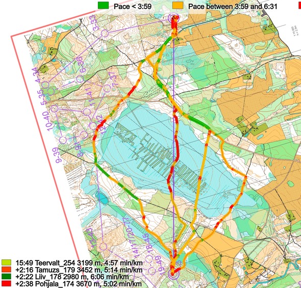
Then you can take a look at how the runners have solved this leg below. The routes are colored according to fastest split time on the leg, with the fastest routes in green and the slowest in red.
Below the routes are colored according to variant to give a clearer view of the how many runners chose each variant.
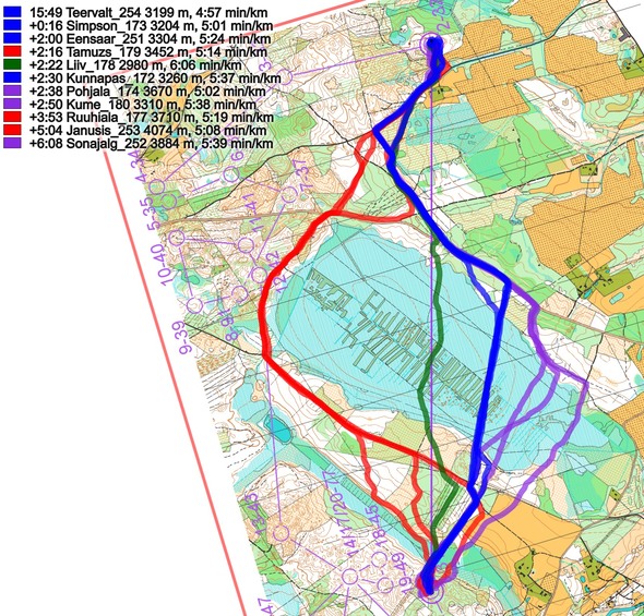
Here is Janis’ take on the leg:
This leg caught me by surprise. It was difficult to assess how slow the marsh could be at the very beginning of the course, so I chose the “safer” north road route-choice (red variant) thinking that I would at least not lose too much time. Unfortunately, many fallen trees from the recent storm had blocked the road near control 12, and it was very slow running there. I lost around 2 minutes because of the route choice. But even without the obstacles, I think that the straight “marsh” route choice would be better by around a minute.
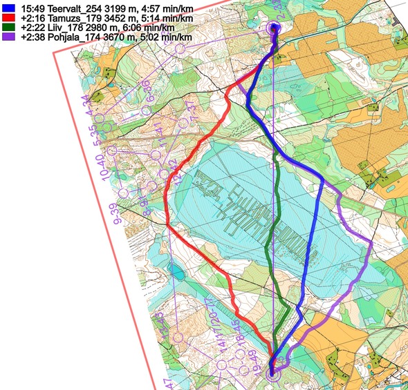
As an add-on to Janis’ analysis, you can look at the pace for the different routes below. As you can see, through the marsh it was actually possible to run below 6:30 min/km for nearly all of the marsh, making this a very good choice!
Density map
See below for a density map of some of the ones who have drawn their routes so far (available during the day when some readers have drawn their route).
Additional information
You find the complete map in omaps.worldofo.com at this location.
Route to Christmas series
The Route to Christmas series is a pre-Christmas tradition at World of O – giving the readers the opportunity to do one Route Choice Challenge each day from December 1st until December 24th. If you have got any good legs in GPSSeuranta, 3DRerun, Loggator or Livelox from 2024-competitions, or old forgotten ones which are still interesting, please email me the link at Jan@Kocbach.net, and I’ll consider including it in Route to Christmas if it looks good. Route to Christmas gets interesting due to YOUR contribute!
Not all legs are taken for the interesting routechoice alternatives – some are also taken because the map is interesting – or because it is not straightforward to see what to do on a certain leg. Any comments are welcome – especially if you ran the event chosen for todays leg!
 World of O News


If you’re still looking for route choice legs for Route to Christmas I’d like to suggest leg 9 from the NAOC Long F21 course (course 10) which is also leg 7 for the M21 course (course 11). You can find the race up on Route Gadget here: https://orienteeringca.nationprotect.net/cgi-bin/reitti.pl?act=map&id=945
I’ve seen lots of discussion online about leg 2 from the men’s course but not much from this leg.
A few notes about the terrain – the forest is runnable but is not super open – you have to fight a bit to really race in this terrain. The ski trails vary from runnable to quite slow with uncertain footing. Generally the steeper the slopes the rougher the vegetation.
Extra note – there was a route that was discussed by athletes after the race which was to go down the trail to the NE and out to the road and around through the arena and then back up the slope. Unfortunately this route wasn’t seen by the course planning team and and a part of the road was covered up by the control descriptions which might explain why none of the athletes saw it during the race. I’d be curious to see if anyone online comes up with that route.
Thanks, Jeff, highly appreciated! I have already looked at the NAOC long since I think it is a very interesting course, but unfortunately it is a bit tricky (and time consuming) doing a full analysis with Routegadget-courses, so I think I’ll have to skip this one, unfortunately.