The first day of Route to Christmas 2013 takes us to Sweden – and the best long distance course from 2013 according to “Course of the Year 2013″.
The race in question is the Swedish Championships long distance – organized at September 22nd 2013 – and we are looking at the very first leg in the men’s class.
Quite a leg to get served as a starter
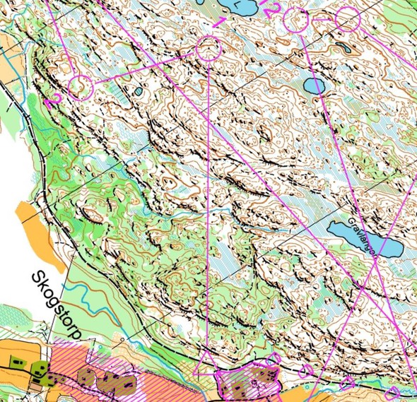
You turn around the map – and this is the leg you see
This is the situation: Start is on the arena with people cheering and the speaker talking you up – in one of the most important races of the year. You turn around the map – and this is the leg you see.
This is quite a leg to get served as a starter when you have to make a quick decision. The paths are small on the map – but do they still give some security in your orienteering? This is not the most tricky leg of the day – but a good and “soft” start of Route to Christmas 2013. Below you find links to study the rest of the course. And please: I need tips for good legs for Route to Christmas 2013 – please send them to jan@kocbach.net!
The leg is as usually first provided without routes – you may take a look at it and think about how you would attack this leg (if the image is too small, you may click on it to get it larger):
Location
You find other maps from the area in omaps.worldofo.com here. See also latest additions in 3DRerun from this area in order to learn more about this terrain type.
Webroute
Next you can draw your own route using the ‘Webroute’ below. Think through how you would attack this leg, and draw the route you would have made. Some comments about why you would choose a certain route are always nice for the other readers.
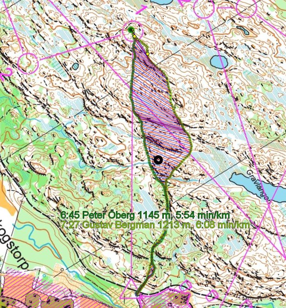
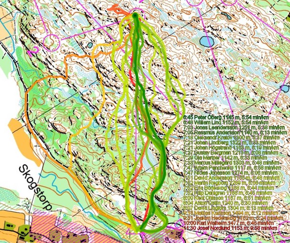
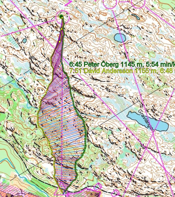
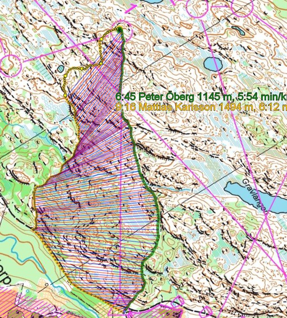
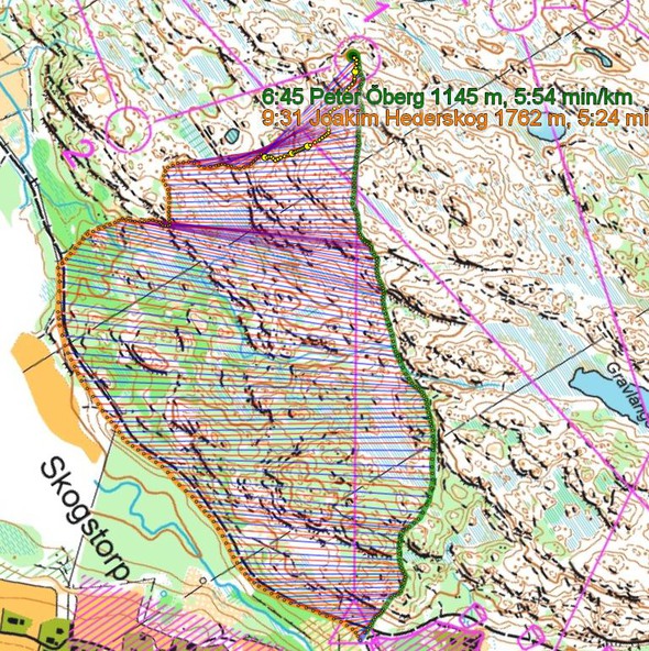
Then you can take a look at how the runners solved this leg below. As you can see from the first illustration, the best route was to find the small, small path to the right of the line, and follow it until the end. From there follow the small stream under the cliffs for some meters – and then just follow on in as straight line as possible to the control.
Many have chosen to go a bit right at the end of the small path – but this gives you many small cliffs to pass. The other route choices to the left of the line are significantly slower.
Below three more illustrations are given – comparing the different route choices in more detail:
Additional information
You find the complete map in omaps.worldofo.com at this location.
Route to Christmas series
The ‘Route to Christmas’ series at World of O has been very popular the last years – and I have therefore decided to continue the series this Christmas as well. If you have got any good legs in RouteGadget, GPSSeuranta or 3DRerun from 2013-competitions – or old forgotten ones which are still interesting – please email me the link at Jan@Kocbach.net, and I’ll include it in Route to Christmas if it looks good. Route to Christmas will not be interesting if YOU don’t contribute.
Not all legs are taken for the interesting routechoice alternatives – some are also taken because the map is interesting – or because it is not straightforward to see what to do on a certain leg. Any comments are welcome – especially if you ran the event chosen for todays leg!
Note that there may be some errors in the Routegadget data (sometimes somebody draws a route for another runner just for fun). Please add a comment below if you spot en error.
 World of O News


Route to Christmas is just great! Really fun. Thank you.
@Ms King: Thanks:) Any tips about legs – please come with them!
Will there be a guess the map this year?
Yes, that’s the plan! But I’ll push it until later this winter (so technically it might not be this year) as there is so much published here in December with Route to Christmas, Achievement of the Year etc.
It will give both the map-guessing and Route to Christmas their deserved attention :-)
Perfect! ;-)
This course (see url) was interesting. Snow was very deep there (April)