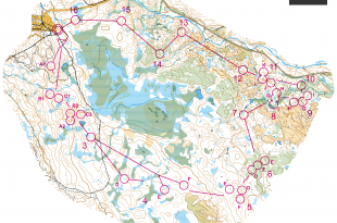
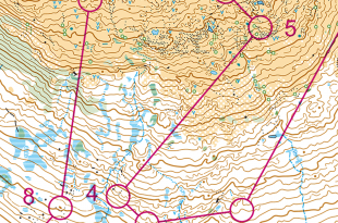
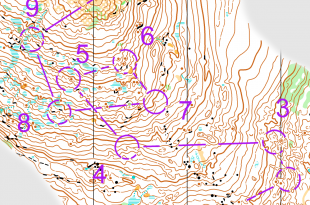
Top 2008 Events: Hungaria Cup 2008

Posted by Jan Kocbach, 02 May 2008@8:00

0hcupc.jpg

How do you orienteer and plan your routechoices in the terrain used for the Hungaria Cup 2008? Hungaria Cup 2008 - staged from July 2nd until July 6th in Hungary - is one of the events featured in the article series “Top Multiday O-events 2008″ at World of O - giving you event presentations with a special twist! Read more about the “Top Multiday O-events 2008″ feature articles here - including information about how to submit your event. The content in this article is written mostly by the organizers, and World of O is not responsible for any inaccuracies.

The terrain - and how to master it!

hcup08sample.gif

The terrain is a usual Central European forest with mixed vegetation, lots of rocks, mostly good runnability and a moderate degree of steepness. You can run at high speed in dominantly easy runnable forest with good visibility. As a result of forestry activities, there is a dense road-system that raises average speed. The area of day 1-2. partially, the terrain of the last two days has never been used for orienteering so far.

Typical routechoice challenges

hcup08leg_s.jpg
In this leg, there are three possibilities:

  • RED: this route choice is technically the easiest, you can run a lot on paths with not too much climbing
  • YELLOW: you are certainly in good shape, if you choose to go straight, because you have to climb the hill, and in addition your compass bearing should be very accurate, if you don’t want to get lost. But on the other hand, this route is the shortest, so it can be worth it.
  • BLUE: this variation is a quite easy route, but you must be more concentrated (in the green area) when you approach the control. Altogether you have to push hard from the very beginning, because there are lots of contour lines.

And which is the best decision? Visit Hungaria Cup 2008 and try it!

0hcupa.jpg

Why choose Hungaria Cup 2008?

… Mobile-O, Mountainbike-O, Mikrosprint, GPS Race, Trail-O or O-Thriatlon - whatever you like …

  • Great opportunity for those wishing to compete in the WOC 2008 as the Hungaria Cup is only one week before in a really similar environment, and it is only 4 hours by car from the location of WOC.
  • The WRE round is great challenge for the best, and will be an exciting experience for supporters.
  • Besides enjoying the 5-day competition, you can test your skills on the accompanying events. Mobile-O, Mountainbike-O, Mikrosprint, GPS Race, Trail-O or O-Thriatlon - whatever you like.
  • Accommodation options are available around the lake of Tata within a radius of 500 meters, and also many opportunities to enjoy programs at night, the company of old and new friends, parties, and celebrate together with the winners, making it memorable.
  • If you have never been in Hungary, it is great opportunity to become acquainted with Hungarian terrains before the WOC in 2009.

You can find all information about Hungaria Cup through World of O Calendar:

Hungaria Cup 2008: More than only orienteering!

… if you only wish to rest on the waterfront in the hot Hungarian summer, plenty of pleasure resorts are awaiting you …

You can explore significant historical sites and the beautiful natural surroundings of Tata or even Budapest after the competition. The castle and the English park of Tata, the fortresses of Komárom or the castles of Várgesztes and Vitányvár, only to mention some of them. The Ászár-Neszmély Wine Region invites you with intimate cellars and excellent wines such as Chardonnay, Sauvignon Blanc Muscat Ottonel or the Cserszegi Fűszeres. But if you only wish to rest on the waterfront in the hot Hungarian summer, plenty of pleasure resorts are awaiting you. Relaxation, leisure, entertainment - what ever you need you will find it.

0hcupb.jpg

Top 2008 events: WOC Orienteering Festival

Posted by Jan Kocbach, 14 Apr 2008@8:00

czetop.jpg
How do you orienteer and plan your routechoices in the terrain used for the Orienteering Festival - accompanying event to the World Orienteering Championship 2008? The Orienteering Festival WOC 2008 - staged from July 14th until July 19th 2008 in Czech Republic - is one of the events featured in the article series “Top Multiday O-events 2008″ at World of O - giving you event presentations with a special twist! Read more about the “Top Multiday O-events 2008″ feature articles here - including information about how to submit your event. The content in this article is written mostly by the organizers, and World of O is not responsible for any inaccuracies.

The terrain - and how to master it!

Same as the World Orienteering Championship 2008, Orienteering Festival will feature various sorts of terrains - from typical central European terrain with mixed forest, lot of vegetation features, deep valleys and erosion gullies, in around 500 mts altitude, to mountains spruce forest with marshes and stone elements in 800 mts altitude. Thus you don’t need to be worry about extremely difficult maps, but still lot of challenges can be found.

OF2008_rocks_ill.jpg

Try to plan your route choices in such a way that you do not approach the controls directly from above…

Some parts of the Orienteering Festival terrain (and also the WOC terrain) will include areas with complex labyrinths of rocky features. Most of these features will be at levels below that at which you approach them, which means they are much more difficult to navigate when orienteering while descending. Also bear in mind that most of the rock features drawn on Czech maps are smaller and more subtle compared with their Scandinavian counterparts. Suggestion is to use also other features - such as clearings, single tress, etc. - when navigating your way through these areas. Try to plan your route choices in such a way that you do not approach the controls directly from above (as shown on the map sample). By moving a short distance along the contour in one direction or another you may obtain a far clearer picture of the terrain. All features will become much easier to read when contouring.

Green areas are very usual in Czech terrains, mapped in detail and frequently used by the course setters. Precise compass control and understanding of the map is necessary. Whenever entering a green area, make sure you know exactly at which place you are entering it and in which direction you are entering it.
czeter2.jpg

Typical routechoice challenges

CZEclassic2007_1_2_1_s.jpg

„Leisure“ runners might prefer longer route around, avoiding as many valleys as possible…

Those Orienteering Festival events which will take place in the same terrains a WOC, will be located to quite hilly areas, with many valleys, situated in various directions. This gives to the course-setter many possibilities to create legs across valleys and hills, where various route choices might appear. This map sample is from men’s elite class route of Czech Champs on Long in 2007, thus not directly from the area of WOC, but still similar (especially to WOC Long/Relay competitions) and giving reasonable idea, what course-setter can create. Of course, what matters most is the ability to make the right decision, since the time difference between the different options can be often quite considerable. So take time to make the right decision before embarking on any such leg. Five to ten extra seconds of thinking can really be a good investment, which will certainly pay off in the end. Unless the leg is at the very beginning of the race, it is important to think of the choice in advance. The right choice naturally depends also on your condition, better trained athletes won‘t be so afraid of more straight choice across valleys. „Leisure“ runner might prefer longer route around, avoiding as many valleys as possible, but it is really important to look at the map carefully – more straight choice might be just a little more hilly but considerably shorter! But in case of long distance competition or hot weather for example, think also of your condition. Physically less demanding choice can pay off with tiredness coming later…

Choices from the northernmost to the southernmost

  • Jan Mrázek – almost longest and amongst the most hilly choice, going so far to north meant descending too much to valleys,
  • Petr Losman – this runner was the fastest on this leg, but since he is excellent uphill runner, others would probably deal slowly with this. Anyway this choice might be considered as good.
  • Osvald Kozák – choice with similar parametres as the of Petr, but more using roads. The middle section of the Petr’s choice through forest might be physically more demanding. This might be considered the best choice, unless for less trained runners, who would probably run more around valleys.
  • Michal Smola – similar choice as the Osvald‘s, and since Michal is top Czech O-runner, the slower time was probably caused by slightly more climbing during second half of the route. (But Osvald was in very good shape at that time and won the race in the end, beating Michal Smola by less than a second after 89 minutes !)
  • Jan Šedivý – not recommended for untrained runners… Quite hilly choice, on which the young perspective Czech team member proved his very good condition…
  • Tomáš Slováček – this runner is not amongst the top-elite ones, thus his time is not written for comparison. His choice is in general the one, which „average“ runner on holiday event would probably take. And also for good runner, this might mean saving of forces for later, even if there is still long way to go.

czeter.jpg

Why choose Orienteering Festival 2008?

This event has the unique advantage against the others – it is organized in parallel to the World Championship and thus the participants can naturally also enjoy the role of spectators of this top O-event. Three stages (E2, E4, E6) will pass in the same terrain as one of the WOC competition, in the daytime after the competition (or in between, in case of middle qualification and final). Three other stages take place in various other locations of the region, thus introducing again another terrains. It is necessary to travel a little bit more to particular stages and in various directions, but this means variability of terrains and also opportunity to see many beauties of the region.

Overall result will be counted from four of the six days, so it is not necessary to run every day and you can concentrate on WOC atmosphere, travel around the region or just relax. Last, but not least, Orienteering Festival is organized as full-value separate competition, not just poor relation to the WOC!

For more info about the WOC and the Orienteering Festival - take a look at the WOC guide.

You can find all information about the Orienteering Festival in World of O Calendar:

Orienteering Festival 2008: More than only orienteering!

… just drinking Czech beer or exploring other specialities of Czech kitchen

Olomouc, with over 100,000 inhabitants, is the fifth largest city in the Czech Republic and is the capital of the Olomouc Region. The city itself gives you many possibilities how to spend free time both with culture, leisure or just drinking Czech beer or exploring other specialities of Czech kitchen. The region all around, in any direction, is rich of various castles, chateaus as well as natural points of interests. The region, where WOC middle distance competition and E4 of OF will be located, is area of Czech second highest mountains Jeseníky.
regpics.jpg
czmat.jpg

Map + report: Lipica open 2008 - Season Opening

Posted by Jan Kocbach, 18 Mar 2008@8:00

lip2_s.jpgFollowing is a short report from Lipicia Open 2008 - the season opening for quite a few elite orienteers in Slovenia a week ago. Winners in the elite categories where Mikhail Mamleev in front of Thierry Gueorgiou in the mens class and Karine D’Harreville in the womens class. Thanks to the organizers for short report and map.

Third time for France National Team

The competition Lipicia Open is a traditional Slovenian competition, and was this year organized for the 17th year. Around 700 runners came from many countries to compete on interesting and technically demanding karst terrain. The same week French national team was in Lipica on training camp (for the third time) what made very strong competition in elite classes. In women class French runners have no equal runners. In ME also Mikhail Mamleev was entered what promised interesting fight on the field. After first day Mikhail was in lead for 28 sec what promised very interesting second day. Especially because of chasing start second day which was organized for the first time on Lipica open. In WE Capucine Vercellotti (French team) was in lead after first day but miss punching on second day stopped her from overall victory. Karine D’Harreville manage to come from 4th position to overall victory.

wclip.jpg

Popular World Champion

Presence of world champion was great opportunity for young orienteers from the region to take pictures and signature of Thierry Gueorgiou. They don’t have many opportunities to see best one on the work. All together one more Lipica open, exiting terrain, challenging courses and 700 satisfied runners althouh weather was not as great as usually.

Map with course

Below you see the map with course from Day 2 in Men Elite. You can find all courses at the event page in RouteGadget (not many routes drawn in Routegadget when this was written):

maplip.jpg

Top 2008 events: O-ringen 2008

Posted by Jan Kocbach, 14 Mar 2008@10:00

oring.jpgHow do you orienteer and plan your routechoices in the terrain used for O-Ringen 2008 in Sweden? O-Ringen 2008 - staged from July 19th until July 25th 2008 close to the Norwegian border in the western part of Sweden - is one of the events featured in the article series “Top Multiday O-events 2008″ at World of O - giving you event presentations with a special twist! Read more about the “Top Multiday O-events 2008″ feature articles here - including information about how to submit your event. The content in this article is written mostly by the organizers, and World of O is not responsible for any inaccuracies.

The terrain - and how to master it!

… a delightful mix of small hills depressions and marshes with a moderate level of detail.

Runners will meet three different types of terrain at O-Ringen 2008. The first two stages ; typical Dalarna terrain with long sloping hills, patches of very detailed terrain, marshes and beautiful old forest. The terrain for the next two stages can be described as delightful alpine terrain where open alpine meadows mix with alpine forest and open pine forest. The level of detail in the terrain varies from a little to highly detailed. The terrain for the last stage is a delightful mix of small hills depressions and marshes with a moderate level of detail. Below you see map samples for these three terrain types.

oringterr.jpg

Typical routechoice challenges

long_route_1.jpg

… climbing extra contours can become a mental, as well as a physical, ordeal

From a route-choice perspective, the biggest challenge facing the runners on this leg is the stretch of low and dense birch forest that covers large portions of the leg. Johan Nordlund and Erik Rost found two different ways to solve this leg.

Johan chose a route that goes pretty straight at the control. He expressed a bit of regret over not climbing earlier and spending more of the leg running across the nice open terrain on top. On the other hand, Johan managed to find a pretty good line through the birch patches. In situations like this, towards the end of a course, when tiredness makes its presence known, climbing extra contours can become a mental, as well as a physical, ordeal. Johan points out that it is important to be very careful with your direction in this type of terrain, as distinct features that can be used for relocation are very rare on the mountainside.

Erik Rost chose a route that mostly went through the white forest below the belt of birch trees. Based on previous experience of training in such terrain, he did this partly to avoid the birch and partly to save some contours.

h60_1.jpg

That stone may be small, but it’s very distinct vis-a-vis its surroundings…

In this next example, we move up a bit in age to H60. This leg is almost flat and goes mostly above timberline, with a more difficult approach to the control through a patch of birches and small pines.

The winner, John Johannson, HJS Vansbro, chose to attack this control straight on. He ran across the open terrain on top, checking off features he passed, and slowed down and became more careful as he entered the green areas on the downslope. He used the distinct gully with a stone near the top as his attack point. That stone may be small, but it’s very distinct vis-a-vis its surroundings, which is why it is mapped here despite its size being below the standard cut-off for mapped stones.

Competitors running O-Ringen 2008 better get used to this small stone size, especially during the so-called “mountain stages”, Stages 3 and 4. These small, but very distinct, stones can be very useful features for relocation up on the mountain side.

Below you see two pictures of typical terrain you will meet at O-Ringen:
oterr2.jpg

Why choose O-Ringen 2008?

In 2008 we welcome orienteers from around the world to Dalarna and Sälen. Already we promise to provide that something extra that makes a competition special, how about…

  • Alpine terrain
  • Indoor accommodation for ALL competitors in cottages, apartments or hotels.
  • Chairlifts to the start on one stage.
  • Event centre in Lindvallen, Sälen and all stages within 15km of the event centre.

You can find all information about O-Ringen 2008 in World of O Calendar:

O-Ringen 2008: A lot more than only orienteering!

This summer we will have the party of the century…

While Sälen is Scandinavia’s biggest winter sports destination, it also has much to offer summer visitors.
Sälen has just about everything you could want in a summer vacation: plentiful lodging options, a rich mountain life, babbling brooks, musical events, family activities, shopping opportunities, restaurants and cafés, fantastic woodland and mountain scenery, and a big dose of peace and quiet. If that’s not enough, you can visit Sälenfjällen´s Moose Park i the nearby village Rörbäcksnäs.

This year we will introduce “Checkpoint Sälen”. The perfect place to hang, for young orienteerers. It will be located in Lindvallen near the O-Ringen Square. Here you’ll find a bar, with the perfect food and drink for young orienteers, an internet café, a relaxation area, the opportunity to play video games, and even the opportunity to try out a few adventure sports.

This summer we will have the party of the century. Högfjällshotellet opens its doors for 2,500 orienteers ready to enjoy a fantastic after-ski (or after-O!) night out. One of Sweden’s very best after-ski bands, as well Sweden’s best O-DJ, will be there to make sure that you have an unforgettable evening. From the dance floor, you can see the sun setting over the mountains. It doesn’t get any better than this!
or.jpg

MOC Overall: Gueorgiou and Riddervold - maps and pics

Posted by Jan Kocbach, 01 Mar 2008@16:05

Thierry Gueorgiou did not manage to take home the last stage of this years Mediterranean Open Championships, but due to his excellent run in the technical challenging terrain yesterday, Gueorgiou nevertheless managed to secure the overall victory in men elite in front of team mate from the French National Team, Francois Gonon. Third on the podium was Øystein Kvaal Østerbø of Norway. In the womens class, Marianne Riddervold of Norway took the overall victory after a very good run today. Second in the women elite category was Mhairi Mackenzie of Great Britain, with Elise Egseth (Norway) in third position. Thus both Gueorgiou and Riddervold could travel back home with a big smile and 800 Euros extra for the prize.

Map with Course: Men and Women Elite

Below you see the courses from the final stage in MOC 2008 for men and women. The terrain looks simple at first sight, but several of the runners - including Thierry Gueorgiou - got a bit surprised by the technical challenges. It was extremely important to keep a good compass bearing - a task which was made difficult by the vegetation. The forest was partly open and very fast runnable, partly dense forest, and partly beach. The beach may seem simple, but when you put your guard down and are tired from running in the sand, even the best can make errors at a simple control at the beach….

mapmen_s.jpg
mapw_s.jpg

Results (unofficial)

Overall Men Elite
1. Thierry Gueorgiou FRA
2. Francois Gonon FRA
3. Øystein Kvaal Østerbø NOR

Overall Women Elite
1. Marianne Riddervold NOR
2. Mhairi Mackenzie GBR
3. Elise Egseth NOR

Pictures

Below you see a few pictures from todays final stage in MOC 2008. (1) 3 best in men and women elite categories overall, (2) Three best women elite overall, (3) Thierry Gueorgiou and Francois Gonon, (4) Thierry Gueorgiou, (5) Francois Gonon, (6) Stig Alvestad, (7) Marianne Riddervold.

imagemoc3.jpg

MOC Day 2 - WRE: Victory for Gueorgiou

Posted by Jan Kocbach, 29 Feb 2008@23:28

- There are not many such technical terrains in the world, Thierry Gueorgiou said after finishing his first World Ranking Event this year. After a, for him, slow start in the sprint yesterday, he was at his best today - beating his team mate in the French National Team, Francois Gonon, with 1 and a half minute. Third was Norwegian National Team runner Øystein Kvaal Østerbø. In the womens class, Norwegian National Team runner Marianne Riddervold took the victory, less than a minute before Swedish Lina Sundqvist and Mhairi Mackenzie of Great Britain.

Map with course

Below you see the first part of the Men Elite course
Courses_MOC_Chiatona.HE1_s.jpg

Results

Men Elite
1. Gueorgiou Thierry FRA 65.25
2. Gonon Francois FRA 66.59
3. Kvaal Osterbo Oyste NOR 67.29
4. Kahrs Christian NOR 74.11
5. Karner Olle EST 74.29
6. Vaher Sander EST 75.06

Women Elite
1. Riddervold Marianne NOR 59.25
2. Sundqvist Lina SWE 60.17
3. Mackenzie Mhairi GBR 61.21
4. Pietila Maria FIN 62.47
5. Egseth Elise NOR 63.32
6. Larsson Linda SWE 63.41

Pictures

Some pictures from todays race are shown below. From the top: (1) Top three in men and women elite. (2) Relaxing at the beach before the race. (3) Francois Gonon. (4) Thierry Gueorgiou. (5) Øystein Kvaal Østerbø. (6) Winners in afternoon city sprint race.

MOC Champs: Map, results & pics

Posted by Jan Kocbach, 28 Feb 2008@15:45

Thierry Gueorgiou had some trouble with a small injury in todays race - which marked the opening of this years MOC Championships - and did not manage to take home the victory. Instead his team mate, Froncois Gonon took the victory in Men Elite - 16 seconds in front of Øystein Kvaal Østerbø. Michela Guizzardi took the victory in the womens class. The MOC Championships started with a city sprint in Citta di Oria in Italy, and will continue with a long distance tomorrow. in the Men and Women elite categories, respectively. Below you see the map with course from the Mens category, which had two loops.

This is my first race of the season, and I am of course very happy to win it…

There was some tricky orienteering around the city castle - which Francois Gonon handled best. - This is my first race of the season, and I am of course very happy to win it, Francois Gonon said after the race. - Øystein did not see the direct route choice to the 3rd control on the second loop, and run all the way around to the left. He was probably faster than me, Gonon continues. Italian Marco Seppi snatched the second place between Gonon and Kvaal Østerbø.

The home victory of Michela Guizzardi in the Women category - in front of strong Norwegian runners - was very popular among the spectators. Second and third in the women’s category where Norwegian National Team runners Marianne Runnervold and Elise Egseth. Only the first loop of the womens loop counted in the overall results.

DSC_2244_s.jpg
DSC_2240_s.jpg

Results (unofficial)

1. Michela Guizzardi ITA 11.36
2. Marianne Riddervold NOR 11.47
3. Elise Egseth NOR 11.48

1. Francois Gonon FRA 18.27
2. Marco Seppi ITA 18.43
3. Øystein Kvaal Østerbø NOR 18.48

Pictures

DSC_2244_s.jpg

Source: MOC Championships

Top 2008 events: OO.cup 2008

Posted by Jan Kocbach, 26 Feb 2008@8:00

oobanner.jpgHow do you orienteer and plan your routechoices in the terrain used for OO.cup in Slovenia? OO.cup 2008 - staged from July 23rd until July 27th 2008 in the western part of Slovenia - is one of the events featured in the article series “Top Multiday O-events 2008″ at World of O - giving you event presentations with a special twist! Read more about the “Top Multiday O-events 2008″ feature articles here - including information about how to submit your event. The content in this article is written mostly by the organizers, and World of O is not responsible for any inaccuracies - and the spelling errors.

The terrain - and how to master it!

There will be 3 terrain types in OO.cup/08, but here we will describe the one which is probably the most interesting. The map extract below is from a typical karst terrain. The only way to master this type of terrain is to be really careful with your orienteering, and to work hard on simplification.

WO_terrain_F.jpg

Typical routechoice challenges

The first stage (also WRE) will be middle distance and this is the kind of leg which you can expect:

WO_test_F.jpg

  • PURPLE: This is a rather safe route, 580m long. The idea is to follow the small paths – simplifying the navigation and taking advantage of the faster speed you can develop comparing to the terrain running. Small paths can be tricky, though, and very easy to miss!
  • GREEN: Probably the fastest route, 480m long. Not just that it’s fastest, it also gives you the most pleasure, as you have to navigate through intricate forms and try to simplify them. One should always try to avoid stony areas on this map, as when it’s drawn stony it’s really stony. Try to navigate on positive forms like hills and ridges, since, unlike depressions, you can spot those from farther distance.
  • BLUE: Or the chicken route :). 680m long. This is fast running and a bit less thinking. Often it will be possible to approach controls by paths. But we will do our best that it will not be worth it!
Why choose OO.cup 2008?

… you can be sure we make no compromises regarding terrain and maps

As always since 2002, we will try to deliver a race in top terrain and on high quality maps. Races of OO.cup/08 will be staged around Ajdovščina, which is situated in the west of the country. Runners will have a chance to experience orienteering in karst forests at different speeds and with different navigational challenges. OO.cup is known as an event organized in a somewhat spartan manner but in friendly and relaxed atmosphere. Coming to OO.cup, you are not to expect luxorious Finish area, but you can be sure we make no compromises regarding terrain and maps.

OO.cup: A lot more than only orienteering!

Hiking and cycling possibilities are rather good in the area. Just above Vipava valley there is a big plateau with highest point Nanos (cca. 1300m). This is a great place for hiking (pictures 1 & 5 below). Very close to Ajdovščina (direction Kras) there are also many small roads with sparse traffic, which are great for cycling. In the area there is also a so called Wine road, by which it is possible to travel and visit farms with home made wine (pictures 2, 3).

Then in the circle of 30-50 km from Ajdovščina you can reach the following: Triglav national park and Soča River (both just 30km from stages 1, 2), Postojna cave (just 10 km from stages 4 & 5, pictures 6, 8), Škocjan caves (UNESCO), Lipica (famous for Lipizzaner horses, picture 7), Adriatic coast (Slovenian or Italian …) and many other points of interest (even Venice is no more than 165km by highway).

WO_area_F.jpg

Top 2008 events: 6 Days in France – Aveyron 2008

Posted by Jan Kocbach, 25 Feb 2008@8:00

france6.jpgHow do you orienteer and plan your routechoices in the terrain used for Aveyron 2008 in Southern France? France 6 Days of 2008 - staged from August 2nd until August 9th 2008 in the Larzac region of France - is one of the events featured in the article series “Top Multiday O-events 2008″ at World of O - giving you event presentations with a special twist! Read more about the “Top Multiday O-events 2008″ feature articles here - including information about how to submit your event. The content in this article is written mostly by the organizers, and World of O is not responsible for any inaccuracies - and the spelling errors.

The terrain - and how to master it!

extraitE6.jpg

The terrain can best be described as a Labyrinthique zone with reduced visibility! There are lots of rocks, relief and many vegetation elements, as you can see at this map extract to the right. To manage a good race, you very well have to manage your speed and raise your eyes as much as possible to observe the most characteristic objects!

Typical routechoice challenges

Maptrack_s.jpg
Take a look at this 400 meter long leg. The map is full of information - there is so much information that you really have to be careful with which part of the map information you use for your orienteering - reading all is close to impossible in high speed! To take the good route, you must know if you are ready to fight with elements, physically and mentally!

There are three main alternatives for this leg:

  • Routes of the North : 560-655 m (25 m elevation). Fast running and post control attack safe, but long!
  • Routes of the South : 560-675 m (35 m elevation). Fast running with a part convenient to the anticipation and post control attack safe, but again long!
  • Direct routes : 470-480 m (30 m elevation). The shortest route, but you have to read the map carefully - especially in the final part !!!

Thus, the direct route is the winning choice and of the most risky at the same time!

Maproute_s.jpg

Why choose Aveyron 2008?

I already know that I will have to face a lot of challenges there… [Thierry Gueorgiou]

The region of Larzac (in the South of France) is a paradise for your holidays of orienteering! This region is one of the most touristic regions of France. The terrains and the maps are exceptional!
- I definitively think that there are only very few terrains in the whole World who can match the difficulties of these ones. I already know that I will have to face a lot of challenges there and that it will be THE hit of 2008! I wouldn’t miss this competition for anything in the world, Thierry Gueorgiou says about the terrains.The organization waits for you for an unforgettable feast of orienteering! You are welcome in the Aveyron.

France 6 Days: A lot more than only orienteering!

A multitude of sites is to be visited ; historic sites (templars towns), natural sites (Montpellier le Vieux, Cirque de Navacelle, les Gorges du Tarn, Aven Armand and Dargilan, etc.), the Viaduc de Millau and the Mediterranean near from there.

This region, it is also the french epicentre of the activities of open air ; mountain bike, canoe, paragliding, caving …

france6b.jpg

1st Kenyan Sprint Champs: Map & Results

Posted by Jan Kocbach, 23 Feb 2008@18:00

KARI_MenElite_s.jpgThe grounds of the Kenyan Agricultural Research Institute (KARI) and a small area of forest belonging to the Kenyan Forestry Research Institute (KEFRI) was the venue for the 2008 Kenyan Sprint Orienteering Championships (see map).
This terrain, roughly 20km west of the capital Nairobi, was chosen for the race at short notice when the original terrain, Uhuru Park in central Nairobi, was closed due to the political unrest in Kenya. A trouble-free event was ensured though thanks to the support of the authorities at KARI and KEFRI who gave permission to use the area and provided other infrastructure, security etc.

… it was especially pleasing to see the great interest for the children’s race where competitors came from both the Bushtrekkers o-club and from schools nearby

The new map (IOF Sprint standard) at a scale of 1:5000 provided an ideal sprint area with both forest and built-up areas. The terrain was mapped in less than a week by Samwel Ndegwa Wanyeki and Esther Wangui Mwihia (Bushtrekkers Kenya) and Ursula Kadan and Thomas Krejci (TV Fürstenfeld Austria). Thomas Krejci also planned the courses. The weather on the day was perfect (lightly overcast and windy with a temperature of 25°C) for the 62 competitors, including guests from Sweden. After brief instructions, the race began at 10.15 when the first runner Micah Samoei (Bushtrekkers Kenya) started off. - Besides the highly concentrated and motivated runners in the main categories, it was especially pleasing to see the great interest for the children’s race where competitors came from both the Bushtrekkers o-club and from schools nearby, according to organizer Thomas Krejci.

While as expected the winner of the women’s elite class was Isabel Moraa, a Kenyan who lives in Sweden, the surprising winner of the men’s elite class was Stephen Kiarie (Bushtrekkers). In spite of difficult training conditions due the lack of maps of forested terrain, Stephen won in the excellent time of 18:01 min on the 2.5km sprint distance. Particularly surprising and pleasing was his clear lead of around 1:30 min to the experienced Swede, Lars Anderson, in second place. The basis for the good performances here and in the future for Bushtrekkers’ runners has been the weekly club training organised since September by Ursula Kadan. The new “KEFRI / KARI” map (800 kB) though means that a significant improvement in the training opportunities is guaranteed. With the well-known athletic capacity of the Kenyan runners (the majority can run 10km under 30 minutes; Bushtrekkers’ club record times are under 28 minutes for 10km and under 65 minutes for the half-marathon), a future breakthrough for runners from Kenya in the international orienteering world is perhaps not so far away.

Source: Press release, Thomas Krejci, Kikuyu-Nairobi-Kenya

image.jpg

Next Page »