[Including some analysis from the races] Maps and full GPS tracking from the Jukola and Venla relays are now available both in GPSSeuranta and in 3DRerun. Upload your own track to compare with the GPS-tracked teams.
See below for instructions on how to add your own GPS tracks to the analysis in 3DRerun/2DRerun.
Selected analysis/observations from Jukola 2014:
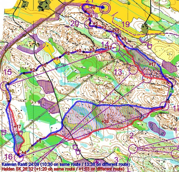
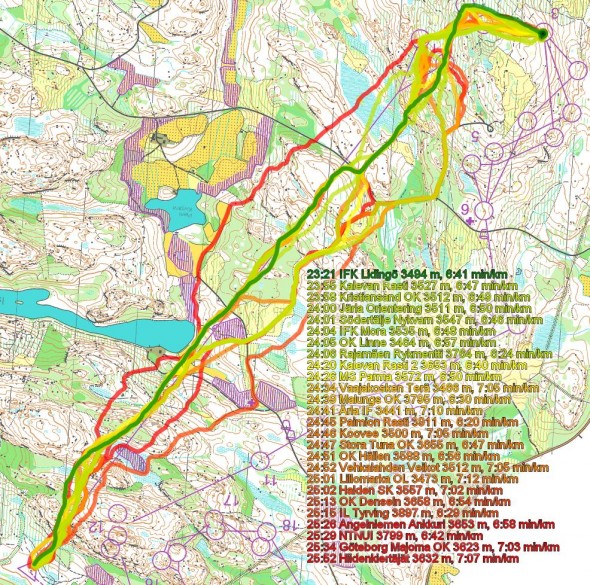
- The above autOanalysis shows a comparison between Kalevan Rasti’s Thierry Gueorgiou and Halden’s Olav Lundanes on the last loop of the 7th leg. Compared to everyone on this leg except Gueorgiou, Lundanes did a good race on this part of the course (except for losing some time on the route choice to 17 which was not optimal). This shows what a great race Gueorgiou did on this last leg – winning the leg with nearly 3 minutes down to Lidingö’s Fredrik Johansson (who was a few meters behind Gueorgiou for large parts of the leg) and with nearly 6 minutes down to the rest of the field. One of Gueorgiou’s best races the last years, for sure.
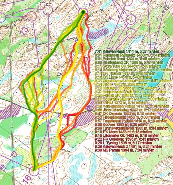
- Above is the leg 16-17 from the last leg by itself. As you can see, left is clearly faster – mainly due to the possibility to run on the path for significant parts of the leg.
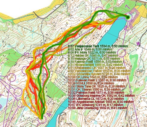
- Above is leg 4-7 on the last leg. Clearly the forking which has the southern 5th control is faster than the northern. Gueorgiou had the northern – and still managed to catch the other teams just after the 8th control.
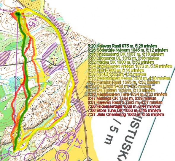
- Above is control 14-15 on the last leg. Straight is fastest, but clearly you can run quite far around without losing time even at day time in this terrain. Hubmann is fastest around, losing around 25-30 seconds to Gueorgiou running direct.
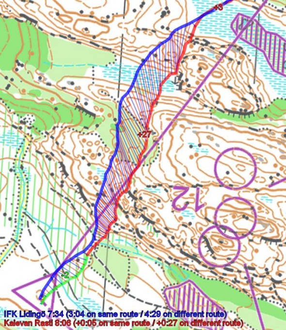
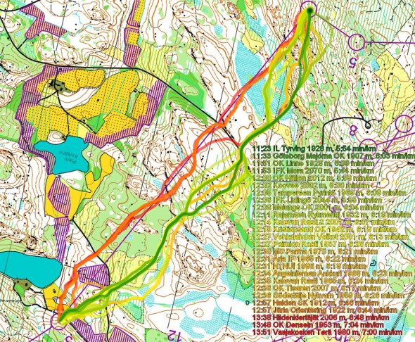
- Above is the first control on the first leg. Note how Lidingö runs very well in a very straight line. This illustration lies a bit, because if you take away Lidingö, the two alternatives are very equal – and there are also less differences between the forking alternatives. Note however how Hiidenidertäjät loses 2:30 on the routechoice to the right – without any other GPS-tracked teams (but there were probably other runners in a group there; actually TP was GPS-tracked and was there for the first part of this leg). Actually it is in the very first part of the leg Lidingö and a few other teams gain an advantage on the rest of the field, by going a bit to the left of the steepest part of the hill (see below)
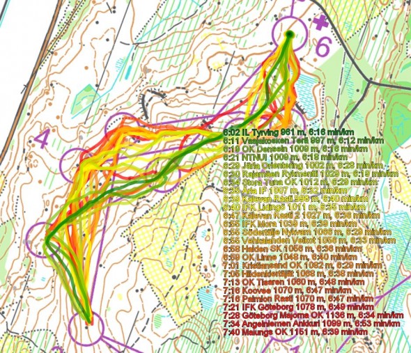
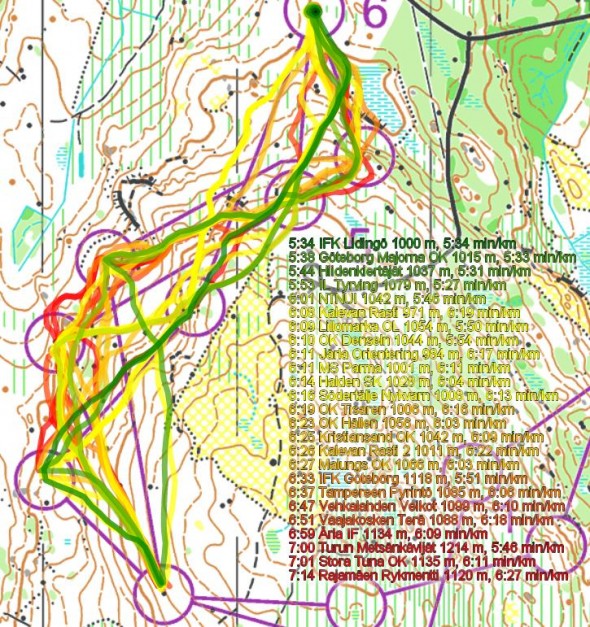
- Above leg 3-6 on the first leg (first illustration) and second leg (second) is shown – the second forked part. It looks like the alternative having the southern 4th control is fastest – but it might also be that these runners were in a faster pack (although with the same picture in two legs … Looking at the third leg might give an even clearer picture)
- Above is the 4th control on the 4th leg. Clearly a place where you could lose some time by taking the wrong route choice – which top teams VaTe and Hiidenidertäjät did – each losing more than 2 minutes to the fastest runners. The problematic part is (1) the green which is slower and (2) that you don’t get the small part of road after the road crossing and (3) the marsh after the road crossing which is quite wet and (4) that the ones with the direct routes hit some cliffs which cost them time.
One could go on for hours with more interesting analyses from the Jukola and Venla relays, but we’ll have to stop somewhere. The GPS-data and analysis tools are available to all, so you can do your own analysis. Please add a comment below (ideally with a link to an illustration) if you have other interesting analyses from the GPS-tracking.
Links to maps & GPS-tracking
|
June 14th 2014 – GPSSeuranta
Jukolan Viesti 1. leg
|
June 14th 2014 – GPSSeuranta
Jukolan Viesti 2. leg
|
|
June 14th 2014 – GPSSeuranta
Jukolan Viesti 3. leg
|
June 14th 2014 – GPSSeuranta
Jukolan Viesti 4. leg
|
|
June 14th 2014 – GPSSeuranta
Jukolan Viesti 5. leg
|
June 14th 2014 – GPSSeuranta
Jukolan Viesti 6. leg
|
|
June 14th 2014 – GPSSeuranta
Jukolan Viesti 7. leg
|
June 14th 2014 – GPSSeuranta
Venlojen Viesti 1. leg
|
|
June 14th 2014 – GPSSeuranta
Venlojen Viesti 2. leg
|
June 14th 2014 – GPSSeuranta
Venlojen Viesti 3. leg
|
|
June 14th 2014 – GPSSeuranta
Venlojen Viesti 4. leg
|
Adding your own GPS-route – making your own analysis
Please use the links below to add your GPS-route to 3DRerun – to analyze them along with the other runners in the relay (you need a user ID in 3DRerun in order to upload routes – registration is done in a minute). You need to have the GPS-file available as a GPX-file – this is possible with most GPS watches available. When your GPS-route is uploaded, you may use this instruction video to understand how to make your analysis. Please ask in the comments to this post if you have any issues.
- Add GPS-route for Jukola leg 1
- Add GPS-route for Jukola leg 2
- Add GPS-route for Jukola leg 3
- Add GPS-route for Jukola leg 4
- Add GPS-route for Jukola leg 5
- Add GPS-route for Jukola leg 6
- Add GPS-route for Jukola leg 7
- Add GPS-route for Venla leg 1
- Add GPS-route for Venla leg 2
- Add GPS-route for Venla leg 3
- Add GPS-route for Venla leg 4
 World of O News


Many thanks Jan !
I had not planned to do any analysis after a long night up following the relay, but then when I started looking at it, there is so much interesting stuff there …. :-)
Thanks Jan for “spicing up” the very good live coverage through the night and for your analysis! When do you sleep? ;-)
In my opinion the differences between some of the forked alternatives were a bit to large. E.g. the 13th control on the last leg (seen in yout first illustration) could have made another result list if not both the best two (three) teams have had the same alternative there.
I agree with Ivar, #13 should not have been used for the last forking on the last leg!
However, it didn’t turn out to make any actual difference this time because KR would have won even if Thierry G had the long alternative here and Lidingö the shorter: I don’t believe Fredrik J would have been capable of running on his own and staying ahead for the rest of the race.
SNO was too far back at this point.
Further back, Olav L for HSK did get the long forking and still caught and passed Paso I, so at least the 5 first places were not affected by this planning mistake.
For me slightly unequal forking is OK. It explains some things.
In Venla the first leg begins with a choice of two forks. It seems the first 18 teams back overall came from one of those. Emma Klingenberg, OK Pan Århus, was fastest overall from the teams doing the other fork at the start. Signe Soes, OK Pan Århus leg 2, ran very well, but also enjoyed a slight advantage from all the teams ahead having the apparently slower fork at the start.
Hi,
Does anyone know how to adjust time on a gpx-file? I can’t simulate mass start in 2D rerun because my activity (with Garmin) starts one hour later than others. I ran the first leg
I already tried to adjust starting time in Garmin connect, but that didn’t work.