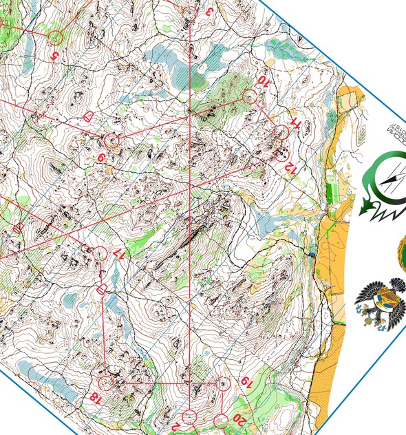
Day 10 of Route to Christmas takes us to a long leg in the Russian Championships in a terrain which looks like a lot of fun to run in: Areas with big stones makes the orienteering tricky in parts.
10 Days – 10 Countries: Sweden, Norway, Switzerland, France, Czech Republic, Russia, Lithuania, Scotland, Italy, Germany. Possible runner-ups: Australia, Hungary, Austria, Finland, Poland + some revisits. Many tips for additional countries, but little GPS-data, quality often goes down & more and more work to prepare. Tips with good GPS-data from “new” countries highly appreciated!
The chosen leg is leg 3 in the H21E course from Russian Championships Long at May 28th 2015 – thanks a lot to Maria Turchenyuk for providing map & split times. We do unfortunately not have GPS-data, but we have the route choices and split times of the three best in the race; Dmitry Tsvetkov, Leonid Novikov and Valentin Novikov. These three chose very different routes – let’s see how many of World of O’s readers choose the fastest route here. The terrain seems to be quite fast, but it is mostly hilly and significant parts of the terrain is stony (some pictures [2] / [3] / [4] to give you an idea of the area). Checking the speed of Natalia Vinogradova in some of the few places with flat, white forest gives a pace down towards 5:30 min/km. On the other hand generally paths are used quite extensively on the routechoices.
The leg is as usually first provided without routes – you may take a look at it and think about how you would attack this leg (if the image is too small, you may click on it to get it larger):
Location
You find other maps from the area in omaps.worldofo.com here. See also latest additions in 3DRerun from this area in order to learn more about this terrain type.
Webroute
Next you can draw your own route using the ‘Webroute’ below. Think through how you would attack this leg, and draw the route you would have made. Some comments about why you would choose a certain route are always nice for the other readers.
Then you can take a look at how the runners have solved this leg below.
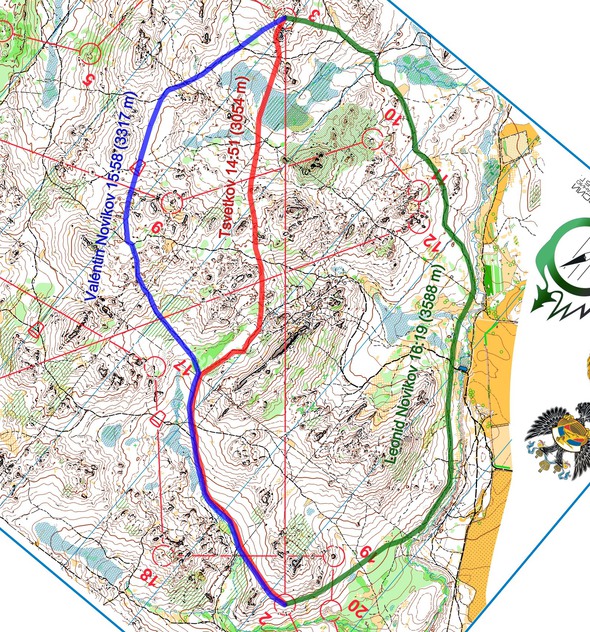
Tsvetkov wins the leg with 14:51 ahead of Valentin Novikov in 15:48. Leonid Novikov has the 4th fastest time on the leg with 16:19. Compare this to the overall results where Tsvetkov wins in 1:24:08 with Leonid Novikov in 2nd with 1:26:12 and Valentin Novikov in 3rd with 1:26:49 – and you can see that the speed of the three has been similar, and Tsvetkov takes half of the final margin on this leg.
Update: Thanks to Kaspar and Raz in the comments, here is the climb for each of the routes: Leonid ca. 100 meter climb. Tsvetkov ca. 130 meter climb. Valentin ca. 160 meter climb.
Even if Valentin’s route has more path running, the part without path for Tsvetkov is mostly flat in white forest without much stones
It thus looks like Tsvetkov’s more direct route is the fastest – he does run 250 meters shorter than Valentin, and thus the time difference on the leg translates directly to the difference in length of the routes [Update: In addition her has 30 meters less climb!]. Even if Valentin’s route has more path running, the part without path for Tsvetkov is mostly flat in white forest without much stones, and thus he can probably keep a speed down towards 5:00 min/km in this area. The part where Valentin is without path is partly very well runnable, but there is also a small part which is more hilly and stony.
Looking at Leonid Novikov’s route all the way around to the right, this is simply too long [even if there is 30 meter less climb]. More than 500 meters (13%) longer than Tsvetkov’s route is simply too much, even if it features a lot of path running [and 30 meters less climb].
PS! If somebody has the initiative to calculate climb for each of the three routes (or additional analysis), I’d be happy to update the article with climb for each route. Thanks Kaspar & Raz!
Density map
See below for a density map of some of the ones who have drawn their routes so far.
Additional information
You find the complete map in omaps.worldofo.com at this location.
Photos from the area


Photos provided by Panoramio. Photos are under the copyright of their owners.
Route to Christmas series
The Route to Christmas series at World of O has been very popular the last years – giving the readers the opportunity to do one Route Choice Challenge each day from December 1st until December 24th. If you have got any good legs in RouteGadget, GPSSeuranta or 3DRerun from 2015-competitions – or old forgotten ones which are still interesting – please email me the link at Jan@Kocbach.net, and I’ll include it in Route to Christmas if it looks good. Route to Christmas will not be interesting if YOU don’t contribute.
Not all legs are taken for the interesting routechoice alternatives – some are also taken because the map is interesting – or because it is not straightforward to see what to do on a certain leg. Any comments are welcome – especially if you ran the event chosen for todays leg!
 World of O News


Leonid 105m
Valentin 160m
Tsvetkov 130m
A quick calculation of contours (may not be completely accurate):
Valentin 33 contours climbed
Tsvetkov 26
Leonid 18
Thanks a lot! That makes
Leonid 90 m / 105 m
Tsvetkov 130 m / 130 m
Valentin 165 m / 160 m