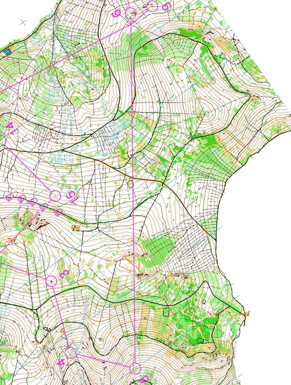
Today the Swiss elite orienteer Baptiste Rollier has been invited to take us to a leg he found memorable in 2015. This takes us back to where we started in this year’s Route to Christmas – to Czech Republic and the Czech Championships Long distance. This time leg 6 in the M21E course is chosen.
According to the Czech runners the type of terrain was quite similar to the one of EOC coming spring. Even if the physical capacities play a big role in such terrain, precise technic and good route choice are key to success. (Baptiste Rollier)
Rollier’s choice goes to the Czech Champs long distance. Here is Rollier’s introduction to the leg:
– The race was held in the mountains close to Sumperk, about 10km away from WOC 2008 middle distance and 50km south of Jesenik where EOC 2016 will take place. According to Czech runners the type of terrain was quite similar to the one of EOC coming spring. Even if the physical capacities play a big role in such terrain, precise technic and good route choice are key to success.
With that, you are ready for the task – and you can even take a look at Day 1 again to freshen up your knowledge on this kind of terrain. The leg is as usually first provided without routes – you may take a look at it and think about how you would attack this leg (if the image is too small, you may click on it to get it larger):
Location
You find other maps from the area in omaps.worldofo.com here. See also latest additions in 3DRerun from this area in order to learn more about this terrain type.
Webroute
Next you can draw your own route using the ‘Webroute’ below. Think through how you would attack this leg, and draw the route you would have made. Some comments about why you would choose a certain route are always nice for the other readers.
Then you can take a look at how the runners have solved this leg below.
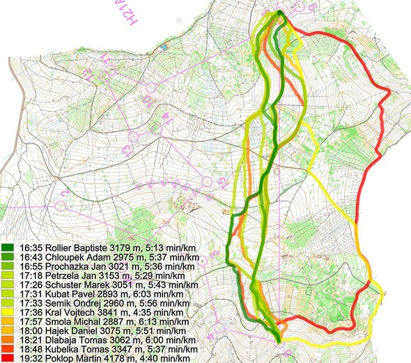
Rollier starts his analysis by looking at the two main options:
– There are 2 main options: more or less straight taking the big or going right avoiding the hill but running more distance (Vojteck Kral). It looks like the right option is little bit slower.
Here is a comparison of Rollier (straight) with Kral – quite clear that you can run so fast direct that there is no use to go all the way around.
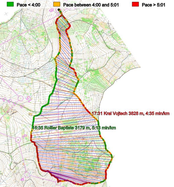
Then the analysis between all the straight choices – you can also lose a lot of time here if you have not got a good plan:
– On the straight option there are many “under-route-choices”.
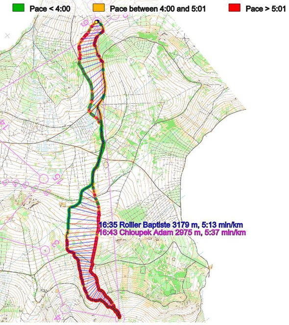
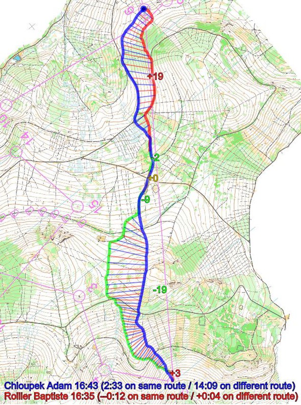
First about saving 20m going more left and avoiding going to the top of the hill. I think there it was better to go left. Usually to take such decision I say myself the 20m extra climb = 200 m extra distance. In this case the extra distance is about 150m (left) and extra climb 20m (straight), therefore better to go left.
Here are two illustrations showing this. The first one shows the pace (you lose time even on the downhill when climbing that first hill) – the second shows that nearly 20 seconds are lost by going over the hill, but part of this is probably due to higher speed for Rollier.
Rollier again:
– The second part of the leg is more about which way is best for attacking the control. The fastest is to go most left and coming flat from the control. That was my first option by then I decided to stay higher to avoid distance (minus 50m) and the risk of running 400m without clear point to the control. But in my choice the runnability was worse and moreover I went to early into the green.
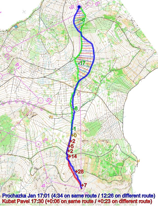
[Comment: You can see this clearly on the illustration above. Rollier loses 19 seconds into the control]– It is also interesting to compare Prochazka and Kubat in the middle part of the leg. There Kubat is faster because he runs less distance even if he does more climb but the climb on the big path is quite fast.
And finally Rollier’s conclusion:
– So to manage well such type of leg 3 parameters are important: distance, climb and runnability. Distance and climb are on the map as well as runnability. But the runnability is also a question of knowledge of the terrain and therefore previous experiences (training/competition before the race or first part of the race itself) are important.
The runnability is also a question of knowledge of the terrain and therefore previous experiences (training/competition before the race or first part of the race itself) are important.
Density map
See below for a density map of some of the ones who have drawn their routes so far.
Additional information
You find the complete map in omaps.worldofo.com at this location.
Route to Christmas series
The Route to Christmas series at World of O has been very popular the last years – giving the readers the opportunity to do one Route Choice Challenge each day from December 1st until December 24th. If you have got any good legs in RouteGadget, GPSSeuranta or 3DRerun from 2015-competitions – or old forgotten ones which are still interesting – please email me the link at Jan@Kocbach.net, and I’ll include it in Route to Christmas if it looks good. Route to Christmas will not be interesting if YOU don’t contribute.
Not all legs are taken for the interesting routechoice alternatives – some are also taken because the map is interesting – or because it is not straightforward to see what to do on a certain leg. Any comments are welcome – especially if you ran the event chosen for todays leg!
 World of O News
