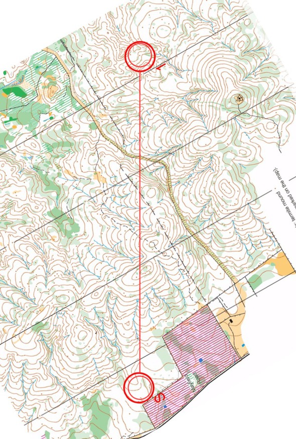
Today’s leg in Route to Christmas is the first leg in the M21A course from NSW Long Championships 2016 in Australia. Andrew Lumsden has provided some introductory comments and also comments from some of the athletes.
Snow Hills is the best spur gully area in Australia. The white is very fast. The ground is hard so the hills are easier to go up than in northern Europe
The leg is as usually first provided without routes – you may take a look at it and think about how you would attack this leg (if the image is too small, you may click on it to get it larger). – The first leg of the M21A 2016 New South Wales Long Distance Championships was highly regarded, Lumsden explains. – It was held at Snow Hills which is between Sydney and Canberra. Orienteering Austalia President, Blair Trewin, says Snow Hills is the best spur gully area in Australia. The white is very fast. The ground is hard so the hills are easier to go up than in northern Europe. The slow run, walk and nearby white forest is usually quite low visibility. If you miss the control, you can easily lose many minutes.

Location
You find other maps from the area in omaps.worldofo.com here. See also latest additions in 3DRerun from this area in order to learn more about this terrain type.
Webroute
Next you can draw your own route using the ‘Webroute’ below. Think through how you would attack this leg, and draw the route you would have made. Some comments about why you would choose a certain route are always nice for the other readers.
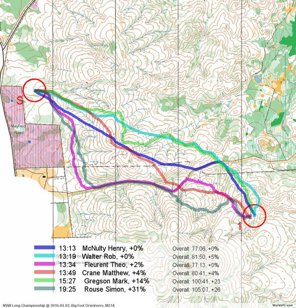
Then you can take a look at how the runners have solved this leg below. As you can see, going fairly straight seems to be the better option. See also some comments from selected athletes below.
Density map
See below for a density map of some of the ones who have drawn their routes so far.
Additional information
You find the complete map in omaps.worldofo.com at this location.
Route to Christmas series
The Route to Christmas series at World of O has been very popular the last years – giving the readers the opportunity to do one Route Choice Challenge each day from December 1st until December 24th. If you have got any good legs in RouteGadget, GPSSeuranta or 3DRerun from 2016-competitions – or old forgotten ones which are still interesting – please email me the link at Jan@Kocbach.net, and I’ll include it in Route to Christmas if it looks good. Route to Christmas will not be interesting if YOU don’t contribute.
Not all legs are taken for the interesting routechoice alternatives – some are also taken because the map is interesting – or because it is not straightforward to see what to do on a certain leg. Any comments are welcome – especially if you ran the event chosen for todays leg!
 World of O News


This was indeed a great area and a good course. The visibility in a lot of parts of the map is lower than usual for Australia, and there are few features except the contours and termite mounds (mounds typically 1-1.5m high made by a species of ant, mapped here as brown dots) – quite fast if you stay in contact, but unforgiving if you lose it.
A World Cup race was held in 2000 in similar terrain (Sunset Mountain) about 5km away, and whilst most of the top runners ran well, there were a few very large time losses by people you wouldn’t expect them from (if I recall correctly Bjornar Valstad and Hanne Staff both made 5-10 minute errors).