Today’s leg in Route to Christmas is leg 14 in the H17-20 course from JWOC Long – thanks a lot for Simon Hector for suggesting the leg and providing lots of analysis!
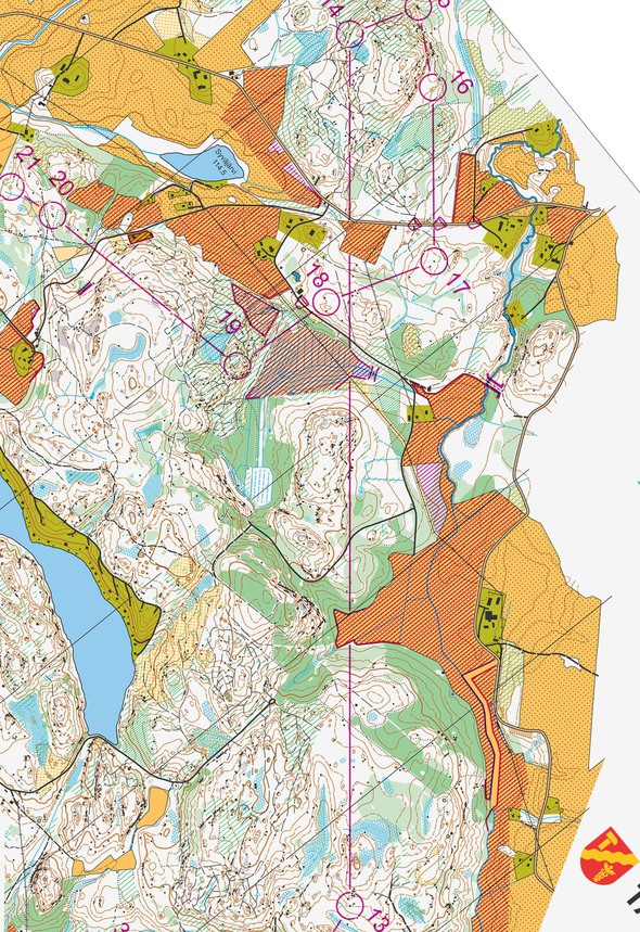
The leg is as usually first provided without routes – you may take a look at it and think about how you would attack this leg (if the image is too small, you may click on it to get it larger).
Before making your choice, read thee thoughts from Simon: The terrain was as often in Scandinavia rather demanding on the floor, not as soft as it can be in some parts of Scandinavia but rather uneven, due to forestry. Because of the forestry, the terrain also had some green areas where you could lose time if you spent too long in them. The visibility was quite good but some trees grew low and many places were flat with few objects, so it was quite easy to lose direction.
Location
You find other maps from the area in omaps.worldofo.com here. See also latest additions in 3DRerun from this area in order to learn more about this terrain type.
Webroute
Next you can draw your own route using the ‘Webroute’ below. Think through how you would attack this leg, and draw the route you would have made. Some comments about why you would choose a certain route are always nice for the other readers.
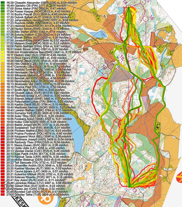
Then you can take a look at how the runners have solved this leg below. Note that split times here are from GPS and not from actual split times.
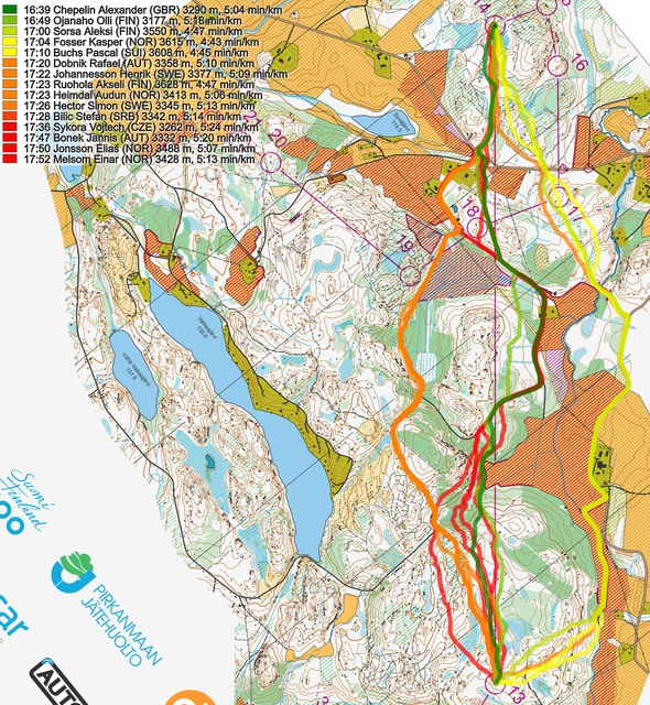
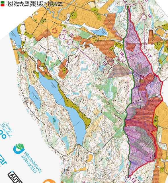
As you can see, going straight is the fastest – but you don’t lose much by taking the street all the way to the right. Here is a comparison for just the fastest to get a bit clearer picture:
And also a comparison with going direct and to the right:
Simon Hector has collected statements for all the Top 10 on this leg:
Alexander Chepelin, Great Britain, 16:36 on the leg (1st), 7th in the race
I think my success on the long leg at the JWOC Long was down to a mixture of experience and luck. I was going through quite a tired stage in my race but I fell just before starting the leg, hit my injured knee and took advantage of a huge adrenaline surge for the rest of the race. Experience on local maps and terrains told me the dark green would be more than passable, no less with a late start and therefore likely tracks. I initially thought to continue my straight route like Olli but the hill didn’t look too nice and I wanted to take my gel, so continued on tracks instead. The route choice taking in the passage in the fields was always tempting, but there seemed to be too much of a risk involved finding the start of the corridor. I concluded it seemed like too much extra distance, and hence more of a risk than the green. So I did what fins do best – I went as straight as I could before it didn’t seem sensible any more.
In general it was a very clean execution and I take huge pride knowing I was the fastest runner for a sizeable section of the race
Olli Ojanaho, Finland, 16:43 on the leg (2nd), 1st in the race
I used a lot of time to plan this leg. The alternatives I was mostly looking at were straight and right along the road. I was a bit unsure about the green area in the middle of the straight option but chose that route because I thought the end would be pretty fast and the whole route was quite flat.
Halfway through the leg I should have taken the road, it’s still hard to say why I didn’t see it. I somehow thought I should attack the small bridge close to the line and didn’t even see that I could run along the road…
Aleksi Sorsa, Finland, 16:53 on the leg (3rd), 4th in the race
I made the decision to use the road option quite easily because I think the green forest on the straight option scared me a little bit. The challenge on my route choice was to hit straight into the narrow gap on the field and I managed to do that well. I could have pushed harder on the road but I used that time to plan out the rest of the course. Approaching the control was easy for me and I did it pretty well. While I was running on the road I thought that maybe this isn´t the best route choice but I didn´t let it bother me. I think my split was only some seconds slower than the fastest split so looking back at this leg now I can say that I´m happy with my route choice but more happy with the execution.
Kasper Fosser, Norway, 16:59 on the leg (4th), 13th in the race
I saw the route going straight at first, but there were some green areas that made it look slow. I saw that going right wasn’t so much longer and had a lot of pure running on road which looked really tempting. After the race I found out that going straight was faster, but not that much, and perhaps if I had an earlier start and there were no tracks through the green areas, it would be better. And of course there are runners that benefit the hard surface more than I do. My execution of the leg was pretty ok, except from a bad first part from the control to the fields where I lost around 30sek, and a smaller misunderstanding of the slopes at the last part of the leg.
Pascal Buchs, Switzerland, 17:04 on the leg (5th), 9th in the race
This route choice was a big challenge for me. I had already set some legs like this during my preparation, but it was never clear which route I would take. I spent around 30 seconds to choose. I first saw three different options: left, straight and right. I directly eliminated the left’s option. It was too much out of the roads and I knew that the small tracks were sometimes quite slow. For the straighter route I was a bit afraid of the green in the middle of the leg. I decided to take the route on the right. I knew also that my physical abilities on the road were quite good. But during the leg I just look at my map and thought that I was going too far away from the line. I was quite sure that my route was not optimal. I started to have a bad feeling and thinking that I was maybe losing one or more minutes. But I anyway tried to push hard and concentrate for the end of the race.
Henrik Johannesson, Sweden, 17:14 on the leg (6th), 11th in the race
My plan was to make it as simple as I could but still quite straight. After some intense orienteering I felt my head was quite tired and I wanted to use as much tracks as I could, to let my head get some rest before the last part. When I ran past the field in the passage on my way to control number 13, I decided to take the left route choice. Touch the turning spot at the first big track and then avoid as much green as possible by running the both bigger and smaller tracks forward to the hydration point south of control 18. Then push hard on the big road, followed by safe orienteering into control 14. Used the small tracks and also got some small rocks which confirmed where I was. My attack point was the big marsh and from there I had the control easy. I am satisfied with this long leg, I made it simple and had good flow all the way, just like I wanted.
Audun Heimdal, Norway, 17:16 on the leg (8th), 5th in the race
I thought the road to the right would be a bit slower than a well executed straighter route choice and it seemed risky going through the green area straight on, so I went for the left route choice. As a late starter I think it would have been faster for me to go straight through the green but I am still satisfied with my choice and the execution.
Simon Hector, Sweden, 17:18 on the leg (9th), 3rd in the race
When I saw this leg I was first surprised because we hadn’t planned for such a long leg when looking at the old maps and I didn’t think the northern area would be used. Then I was surprised because I only found one route choice, the one which I later took. I figured the course setter might have tried to trick us so I looked closely for other possible routes but didn’t find any other route choice which made sense to use for me. Then it was all about executing that route as good as possible. I hit the crucial passages like planned and tried to make use of the small rides as much as possible to keep the speed up. I am happy with my plan and execution of this leg, and it was fun to get this kind of challenge, mixed with other orienteering challenges during the course!
Akseli Ruohola, Finland, 17:20 on the leg (10th), 8th in the race
My first plan was to run the long leg straight but then I finally decided to take the right route choice because of the roads and paths. In fact I changed my plan after having taken already few steps straight. Making the decision took almost 15 seconds for me after leaving the control. When I had done my choice my plan was first to run with the compass direction to the marked field because I supposed it to be very visible in the forest. But it wasn’t. This was the first uncertain situation in this leg. Luckily I managed to find the hole of the marked route on the field. I should have read more details before the field to be sure that I come to the field straight. While running the field and road I read end of the course already. In the end of the leg my plan was to use the trails to keep up the good pace. But I did a mistake when I read too much the trails and ignored the contours. Then I ran through the thicket where I lost plenty of time. And after that I was a bit lost but managed to correct my direction fast. Then I ignored the trails and trust my compass and read the contours. I knew that the control was just above the top of the hill next to large swamp. I benefit the good visibility and saw the rock (with my control) far away.
It is also interesting to see the course setters BIG analysis here.
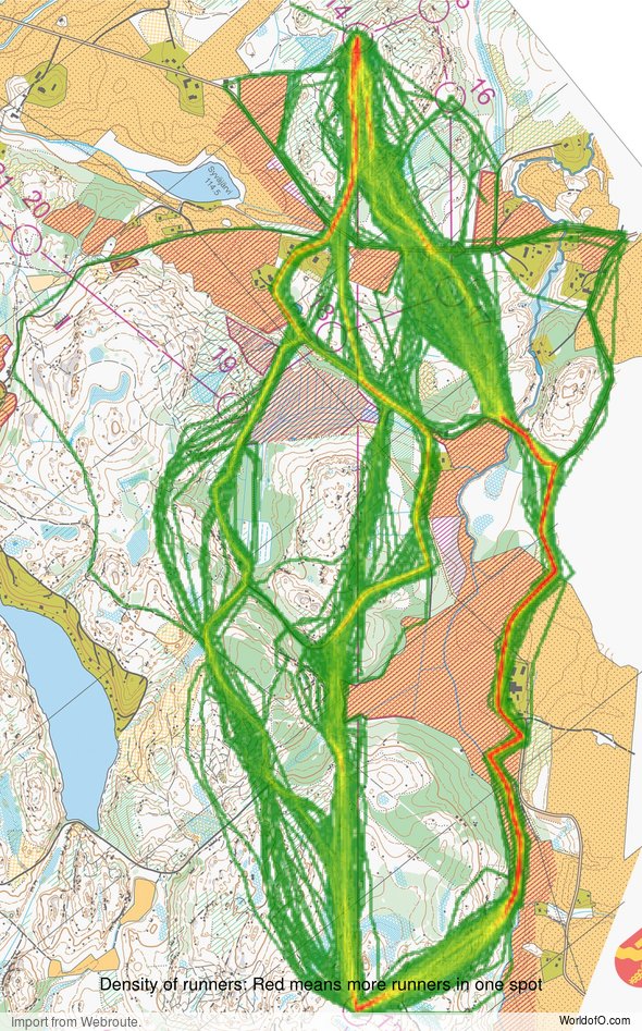
Density map
See below for a density map of some of the ones who have drawn their routes so far.
Additional information
You find the complete map in omaps.worldofo.com at this location.
Route to Christmas series
The Route to Christmas series at World of O is a pre-Christmas tradition at World of O – giving the readers the opportunity to do one Route Choice Challenge each day from December 1st until December 24th. If you have got any good legs in RouteGadget, GPSSeuranta or 3DRerun from 2017-competitions – or old forgotten ones which are still interesting – please email me the link at Jan@Kocbach.net, and I’ll include it in Route to Christmas if it looks good. Route to Christmas will not be interesting if YOU don’t contribute.
Not all legs are taken for the interesting routechoice alternatives – some are also taken because the map is interesting – or because it is not straightforward to see what to do on a certain leg. Any comments are welcome – especially if you ran the event chosen for todays leg!
 World of O News
