In today’s leg in Route to Christmas we are travelling north in Norway to a long leg in a tricky, stony mountain-type terrain in the Oppdal area, south of Trondheim. Enjoyable leg in enjoyable terrain!
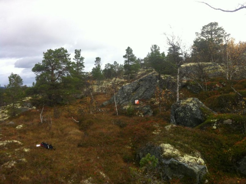
The course in question is the Men Elite course from O-Festivalen – the largest orienteering race in Norway. The terrain is Oppdal is characterized by pine forest with good visibility and with increasing occurrence of birch upwards the slope. More dense parts occur. Parts of the terrain is stony and has some large boulders and blocks – see picture below (photo from organizer’s webpage).
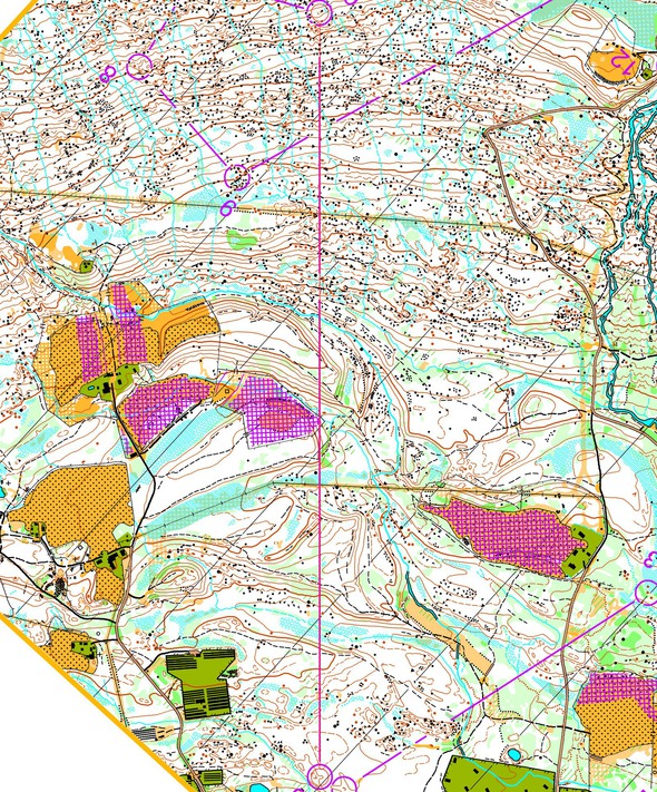
The leg is as usually first provided without routes – you may take a look at it and think about how you would attack this leg (if the image is too small, you may click on it to get it larger).
Location
You find other maps from the area in omaps.worldofo.com here. See also latest additions in 3DRerun from this area in order to learn more about this terrain type.
Webroute
Next you can draw your own route using the ‘Webroute’ below. Think through how you would attack this leg, and draw the route you would have made. Some comments about why you would choose a certain route are always nice for the other readers.
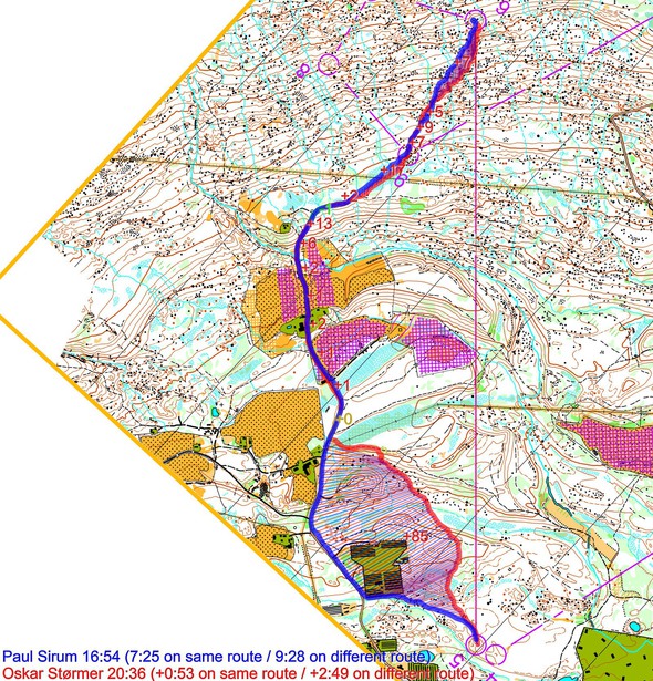
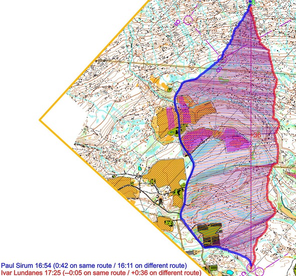
Then you can take a look at how the runners have solved this leg below. As you can see, most runners chose to run direct with quite tough running all the way – but the clearly fastest time was run by Paul Sirum to the left. Due to all the micro-routechoices on the direct route, the risk for non-optimal execution and losing extra time direct is probably higher than going to the left.
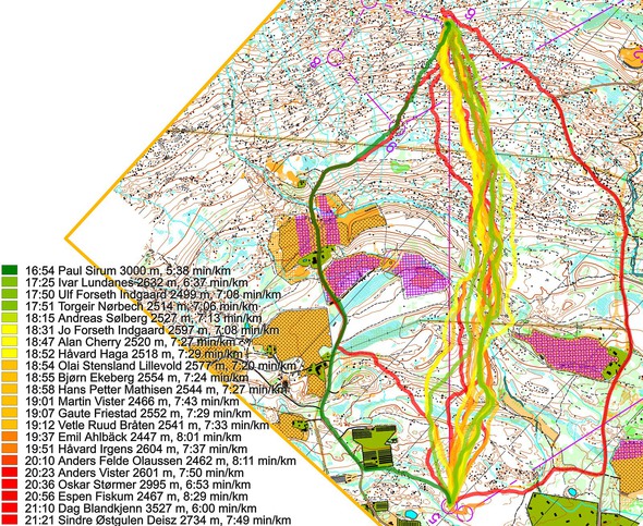
The route to the right is actually not as bad as it looks here – the only runner taking this route missed the control, and would have been around 2 minutes behind the best split time without this mistake:
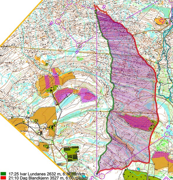
Here is a comparison between the two left alternatives: You should run to the road as early as possible if going left:
Then a comparison left versus the best direct route:
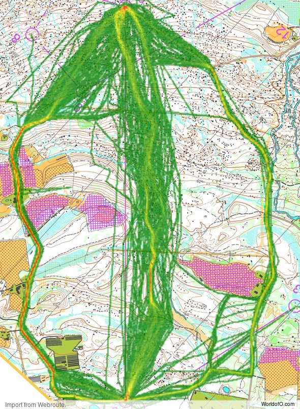
Density map
See below for a density map of some of the ones who have drawn their routes so far.
Additional information
You find the complete map in omaps.worldofo.com at this location.
Route to Christmas series
The Route to Christmas series at World of O is a pre-Christmas tradition at World of O – giving the readers the opportunity to do one Route Choice Challenge each day from December 1st until December 24th. If you have got any good legs in RouteGadget, GPSSeuranta or 3DRerun from 2017-competitions – or old forgotten ones which are still interesting – please email me the link at Jan@Kocbach.net, and I’ll include it in Route to Christmas if it looks good. Route to Christmas will not be interesting if YOU don’t contribute.
Not all legs are taken for the interesting routechoice alternatives – some are also taken because the map is interesting – or because it is not straightforward to see what to do on a certain leg. Any comments are welcome – especially if you ran the event chosen for todays leg!
 World of O News


Something’s wrong with the density map!
Thanks, Alex. I fixed it earlier today. It happens when somebody else makes a webroute between the time I prepare the Route to Christmas (usually the day before) and the time it is published. Sorry about that!
Thanks for keeping me entertained in December, I’ve really enjoyed it. My route choice usually matched the highest density webroute , but that was not always the fastest one on the day.
Thanks a lot for nice feedback, Alex!
I am a bit disappointed that you say Oppdal is north in Norway when actually it is only 1/3 on a line from south to north. Would have been great to see some long legs from the real north of Norway, but unfortunately there are not too many GPS routes from the competitions there.
I know:) I’m very happy to include one from real Northern Norway if you have one to offer!