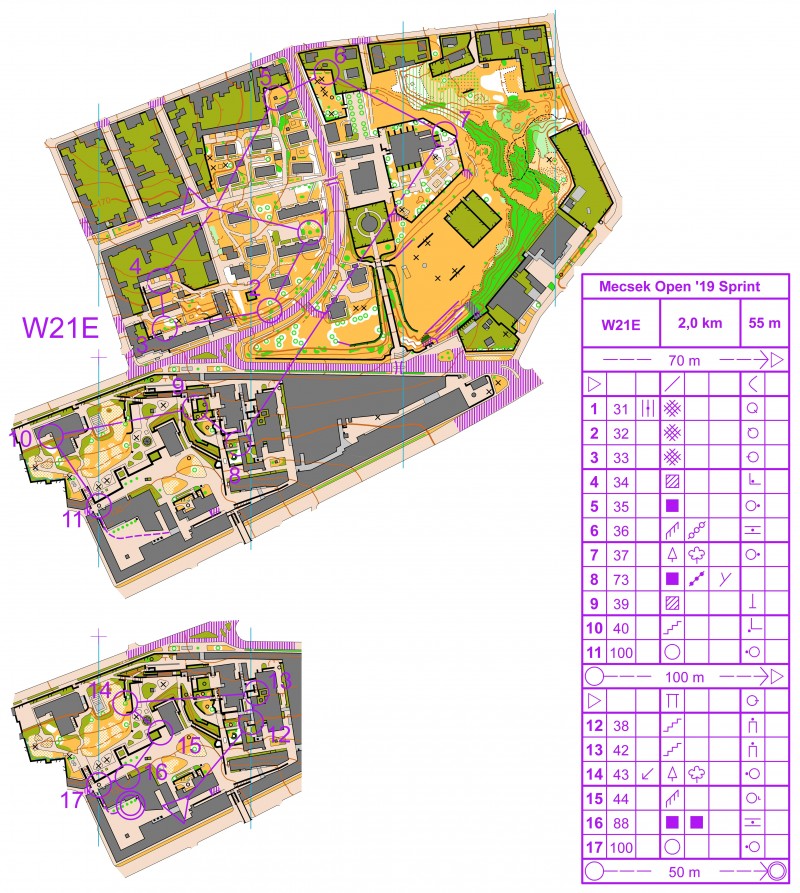
Today’s leg in Route to O-Season 2020 is the first sprint leg in this series, the first leg from a women course, and the first leg from Hungary. The chosen leg is the 8th leg in the W21E course from Mecsek Open 2019. Thanks a lot to János Kelemen for the tip and prepared routes.
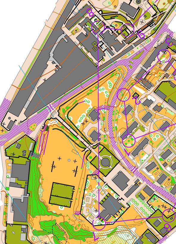
The leg is as usually first provided without routes – you may take a look at it and think about how you would attack this leg (if the image is too small, you may click on it to get it larger):
Location
You find other maps from the area in omaps.worldofo.com here. See also latest additions in 3DRerun from this area in order to learn more about this terrain type.
Webroute
Next you can draw your own route using the ‘Webroute’ below. Think through how you would attack this leg, and draw the route you would have made. Some comments about why you would choose a certain route are always nice for the other readers.
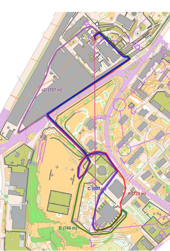
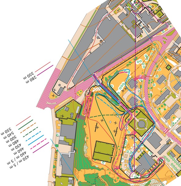
Then you can take a look at the main alternatives below. In the first map I have drawn the main alternatives. In the second the course setter has drawn many additional variants. The takeway message here is as follows:
- It takes time and effort just to understand what are the possible routes – when that’s done many might just take the first viable route they can see (probably the green one, or a combination of green and purple?)
- For the first part of the leg (until the big building) it is tempting to run the green route (out the back and around to the left), but it is more than 50 meters shorter to run over the bridge and back loop back under the bridge again (blue). You lose some time due to all the curves you have to run, but 50 meters should be enough to make it worthwhile to take the “bridge” route.
- For the second part of the leg, it is clearly shorter (70 meters) to run around to the right (blue versus purple)
Unfortunately this leg was never run exactly as it is due to closing of a passage, but as a theoretical exercise it was still a great leg!
Density map
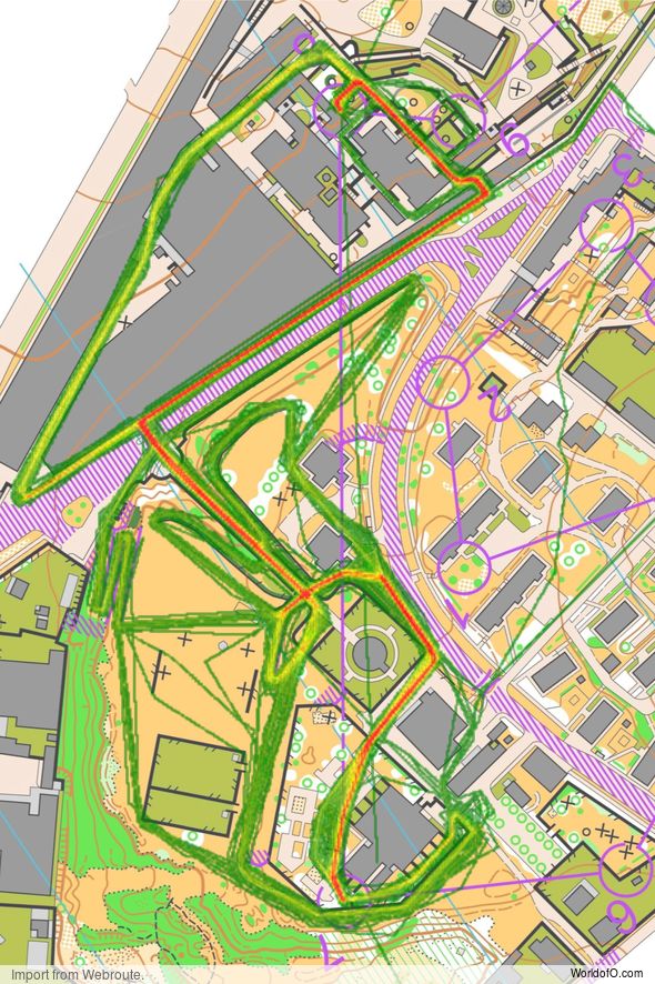
See below for a density map of some of the ones who have drawn their routes so far (available during the day when some readers have drawn their route).
Additional information
You find the complete map in omaps.worldofo.com at this location.
Route to O-Season 2020 series
Route Choice Challenges while waiting for the real action: With the upcoming orienteering season indefinitely on hold in large parts of the the world due to COVID-19, regular orienteering route choice challenges may be one way to make sure those orienteering skills don’t get completely rusty. I’ll try to keep these coming daily, but need help from all of you out there to keep them coming and to keep up a certain quality.
Tips on good route choice challenges – either from races/trainings (even cancelled ones) or theoretical ones with accompanying analysis – are very welcome (please e-mail to jan@kocbach.net).
Not all legs are taken for the interesting routechoice alternatives – some are also taken because the map is interesting – or because it is not straightforward to see what to do on a certain leg. Any comments are welcome – especially if you ran the event chosen for todays leg!
 World of O News


I most certainly disagree with the statement that this a great leg. If you maybe have to stop for 10-15 seconds and identify possible routes first (because it’s simply impossible to solve it while running, not to speak about route selection), does this still make a great sprint leg? Does this fulfill the definiton of the discipline?
We had a similar discussion after Czech Cup in Pilsen and then again after WC in Mladá Boleslav – if studying the route costs you 15″, then you still choose the wromg route, which means additional 30″ and the race for you is pretty much over, does this make a good sprint course?
Please do not glorify such routes, during a good sprint race the routes should be visible immediately, it’s all about route selection in high speed.
Thank you ;)
Thanks a lot for your comment, VN. This is an interesting discussion which I definitely welcome. In general I agree that you don’t want too complex “labyrinth-like” legs, but this particular leg is well within what I think is fair, and which an elite orienteer can figure out fast enough. 15-20 seconds to find the best route is no problem at all for the most tricky leg on the course (although I think the best runners are much faster than that) – that is done while running earlier on the course. You can’t always start thinking about your routechoice when approaching the control – here you really have to preplan. Who talked about stopping for 10-15 seconds? For this particular leg:
(1) You can quickly understand that the leg has two halves which can be handled separately.
(2) The second half is quite easy to handle (you can also handle it while running the first part)
(3) The first half is the “tricky” part. However, it is short and it is completely flat, so you don’t need to care about altitude differences. Also, it isn’t actually very “labyrinthic” if you look at what you really have to solve here:
I tend to agree with VN on his assessment that this leg – and the complete race – was made unnecesseraly complex by the course setter. The excessive usage of out-of-bounds areas and lines is a very dangerous tool, in this case this just transforms the terrain into an artificial labyrinth. One might argue, that given the relative simplicity of this part of terrain, this was the only solution, but this coudl have been achieved by less extra addition as well.
Looking at the result list (http://admin.mtfsz.hu/fajl/get/fajl_id/20922/tipus/render) one might notice the unsually high ratio of disqualified atheletes (M45 was an extreme case). I believe the this supports my argument above.