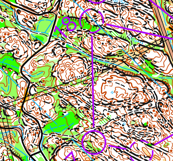
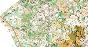
Today’s leg in Route to O-Season 2020 is a leg in very detailed “fight”-terrain in Norway – from the Norwegian O-festival long distance race. We already visited this race in “Route to Christmas 2019 Day 10″, but then we studied a longer leg. Now we have a quite short leg in the women elite course, towards the end of the course.
The leg is as usually first provided without routes – you may take a look at it and think about how you would attack this leg (if the image is too small, you may click on it to get it larger):
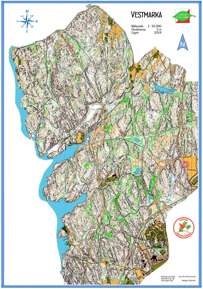
Location
You find other maps from the area in omaps.worldofo.com here. See also latest additions in 3DRerun from this area in order to learn more about this terrain type.
Webroute
Next you can draw your own route using the ‘Webroute’ below. Think through how you would attack this leg, and draw the route you would have made. Some comments about why you would choose a certain route are always nice for the other readers.
Then you can take a look at how the runners have solved this leg below. As you can see, going straight seems to be clearly faster here, with the two fastest times being run straight. Probably many of the ones in front of the computer took the straight route, but for those running a long distance in this though terrain, you had to be a tough one to dare to go straight when there is finally a chance to rest a bit and run around.
Course setting competition
An interesting side note: The Norwegian Orienteering Federation is organizing a course setting competition on this very map with deadline at the end of this week to keep people’s orienteering brains active in these COVID-19 times – the job is to set a 9-12 km long distance course (all about it here). Shouldn’t be too difficult to set some interesting legs here, I would say. I hope to get back with some of the most intriguing legs later in “Route To O-Season 2020″.
Density map
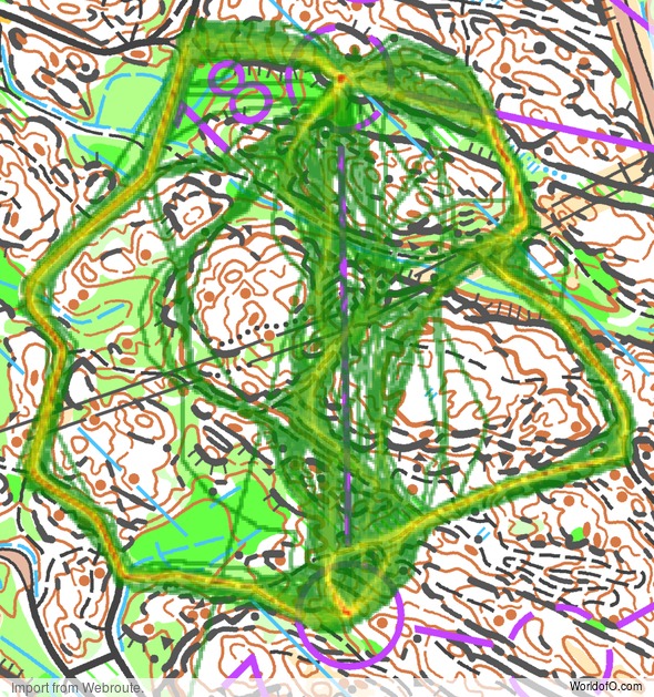
See below for a density map of some of the ones who have drawn their routes so far (available during the day when some readers have drawn their route).
Additional information
You find the complete map in omaps.worldofo.com at this location.
Route to O-Season 2020 series
Route Choice Challenges while waiting for the real action: With the upcoming orienteering season indefinitely on hold in large parts of the the world due to COVID-19, regular orienteering route choice challenges may be one way to make sure those orienteering skills don’t get completely rusty. I’ll try to keep these coming daily, but need help from all of you out there to keep them coming and to keep up a certain quality.
Tips on good route choice challenges – either from races/trainings (even cancelled ones) or theoretical ones with accompanying analysis – are very welcome (please e-mail to jan@kocbach.net).
Not all legs are taken for the interesting routechoice alternatives – some are also taken because the map is interesting – or because it is not straightforward to see what to do on a certain leg. Any comments are welcome – especially if you ran the event chosen for todays leg!
 World of O News
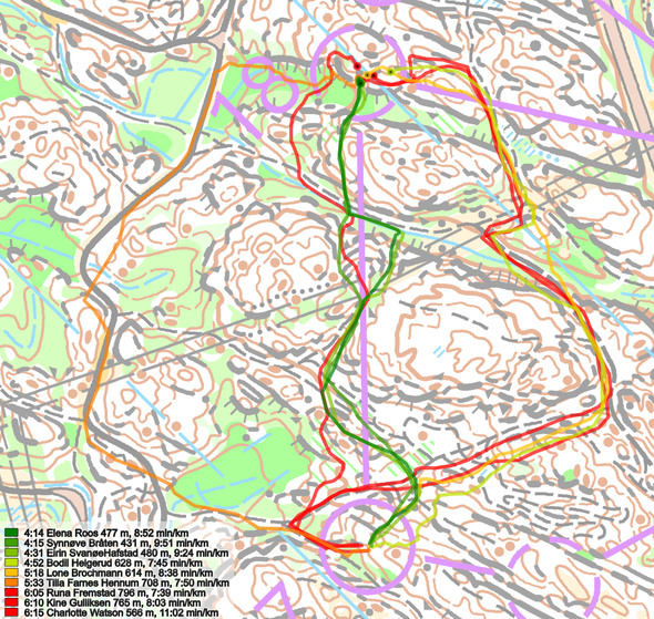


Thanks for including this interesting leg, I was technical delegate for the course in this event, supporting course setter Ole P. Aasrum from organizer Larvik OK. It was surprising to me that straight was best, but although the running speed of the competitors in women elite in this event vary quite a bit, and many were running in groups at this final part of the chase start event, I do think now that the conclusion is correct. The reason is probably, as usual, a combination of length and climb. Running left f.ex. gives you some 10-20 meter more climb than going straight as Elena Roos, the road section is actually quite hilly! And the entry to the control from left is uphill in tough and slow terrain. Going right only saves you little bit of climb 5-15 meter, and it is longer than it looks due to the Z-swing you have to take when passing the powerline. Moreover, the entry to the control is either green, hilly or long depending on how you decide to approach the control in the end of leg on this right route-choice. In conclusion, even though it is for sure possible to run the right route-choice with a good leg-time, here you should stick to the old route-choice recommendation: “If you are in doubt about running left or right, go straight!”
Thanks a lot, Knut – very nice to hear your thoughts about the leg!
I think Knut’s explanation must be correct, just like him I really expected the right-hand alternative to be the fastest, but just a little bit faster than left, with straight as the worst. There is actually one more possibility and that is related to the starting time of the fastest ladies: If they started relatively late, then there might have been some partial “elephant trails” through one or more of the green patches. I know that I was also surprised last year when people on my own course had run a route along a green & wet valley, without losing any time.