World of O News
Today’s leg in Route to Christmas 2021 is more of an orienteering puzzle than a normal orienteering leg – so you might need to set aside some time to figure this one out. Thanks a lot to Robert Graham for the tip!
The leg is from a complex multi-lever sprint training session in Ottawa, Canada organized by Jeff Teutsch – thanks also to Jeff for the write-up and his work on the leg. This is way beyond what you will usually meet in a sprint training or race, and to make the right choice here you should definitely invest some time in understanding how to cross from one level to another, and how to read the map. For a full description of the training, see this blog post (which also gives the solution of the leg). The important parts to understand the leg are included below the image of the leg.
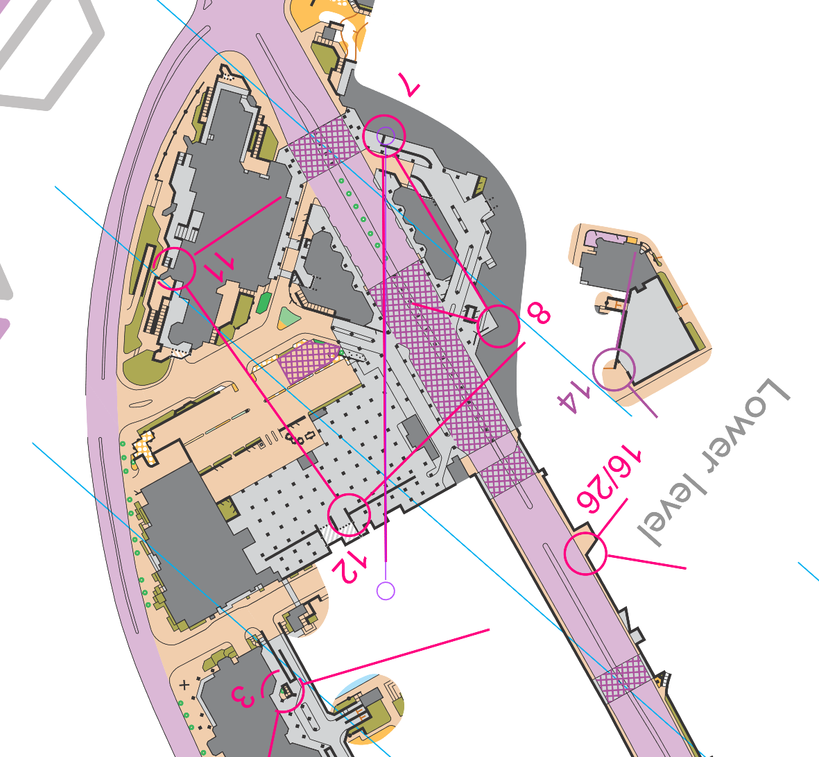
The leg is as usually first provided without routes – you want to go from control 6 to control 7. You may take a look at it (including the lower level below) and think about how you would attack this leg (if the image is too small, you may click on it to get it larger). But you’ll probably need to read the detailed description below and then go back to the leg again to do your choice.
![]()
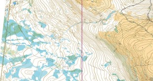
And here is the additional map for the lower level:
And the upper level :

And the control description (you can identify north based on the way letters/numbers are written):
The following information might help (taken directly from the blog post):
- The first page of the map has used multilevel mapping symbols as per the newish ISSprOM. The second page of the map has maps of just the upper layer and the lower layer which are helpful in showing those levels more clearly.
- Control circles have been coloured to help indicate which level the control is on:
- Pink circles are on the lower level (control 7)
- Blue circles are on the upper level
- Standard purple circles are in an area where there is only one level (control 6)
- You can’t cross the main road ‘Blvd de la Maisonneuve’ at street level but you can run up and down the sidewalk on both sides.
- Take the time to figure out where you can cross from one level to the other:
- o There is a hard to find staircase between controls 9 and 10 that goes between levels (it’s extra complicated there – I couldn’t come up with a good way to map it ☹).
- A quick explanation of the multi-level mapping:
- Simple canopies are shown in the standard grey canopy symbol. This symbol is also used very heavily in the lower level map
- Areas where you can run on the upper and lower levels, or where using the grey canopy would result in a disjoint in the map, have instead been mapped with striped colour and bridge and tunnel symbols (see labelled images below):
- a: Areas where you can access the lower level are shown with the ‘bridge’ symbol.
- b: Key walls in the lower level including the main walls of the tunnel have been shown with a square dotted line. In cases where the wall cannot be confused as being on the upper level a solid wall symbol has been used.
- c: The colour of the striped area represents the upper running surface. You can run under but not on olive green and dark grey (building) stripes.
- d: Where the lower level is out of bounds the upper level has been shown in solid colours to indicate you are not allowed to run underneath it.

Location
You find other maps from the area in omaps.worldofo.com here. See also latest additions in 3DRerun from this area in order to learn more about this terrain type.
Webroute
Next you can draw your own route using the ‘Webroute’ below. Think through how you would attack this leg, and draw the route you would have made. Some comments about why you would choose a certain route are always nice for the other readers.
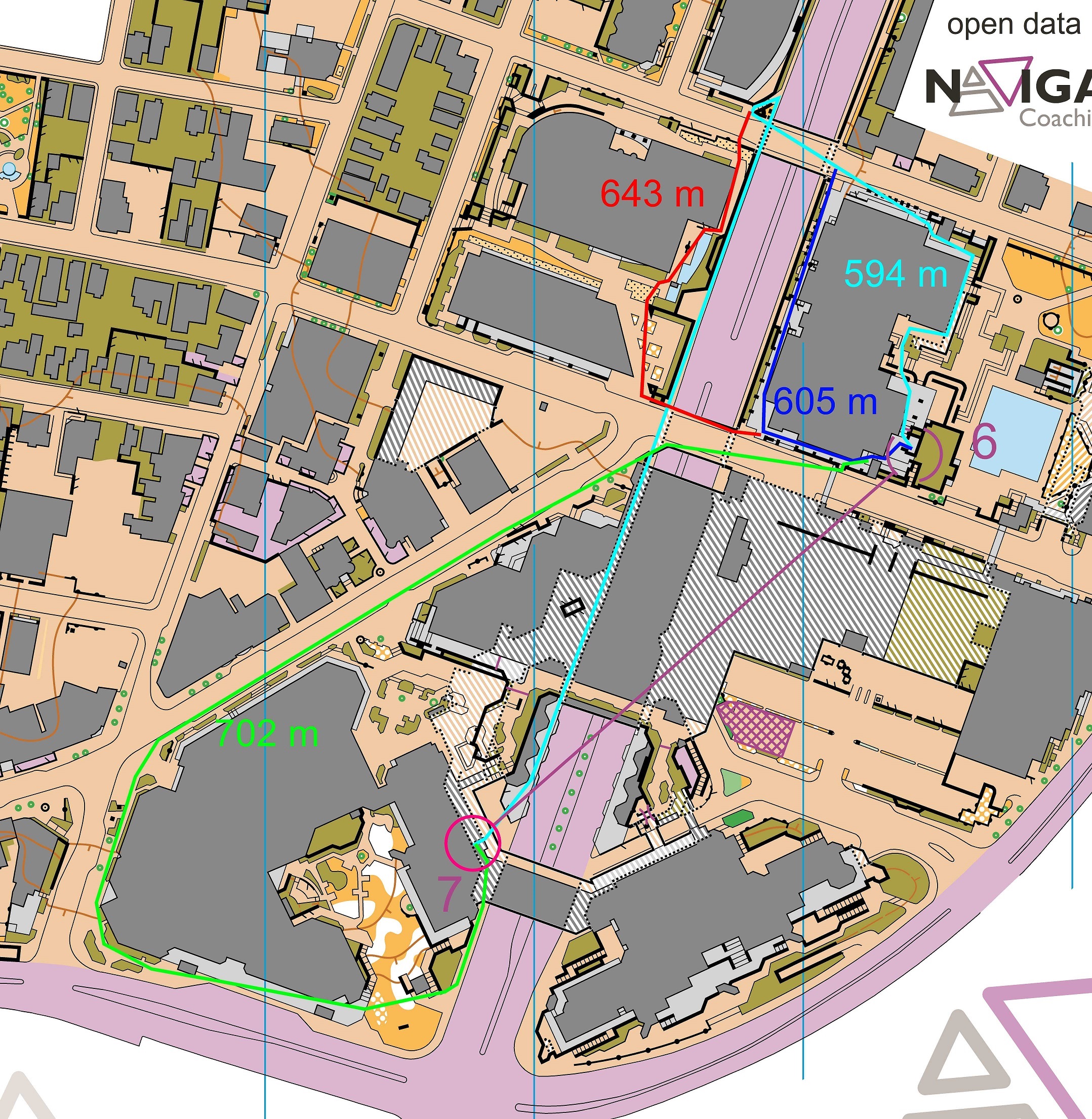
Then you can take a look at how the course setter has measured up the alternatives below. Here is his analysis of the leg:
Leg 7 – With this leg the key is to figure out two things: how do you cross Boulevard de la Maisonneuve (the N-S street) and then how do you get to the lower Boulevard de la Maisonneuve level. Their are two ways to do this: a) crossing and descending the stairs to the north, and b) crossing and then looping around the office complex and approaching from the south. Taking the stairs to the north is shorter and faster. Looking at the lower level map once you get to the lower level can help you find the control more smoothly.
I have to admit that I did not get it right – did you?
Density map
See below for a density map of some of the ones who have drawn their routes so far (available during the day when some readers have drawn their route).
![]()
Additional information
You find the complete map in omaps.worldofo.com at this location.
Route to Christmas series
The Route to Christmas series is a pre-Christmas tradition at World of O – giving the readers the opportunity to do one Route Choice Challenge each day from December 1st until December 24th. If you have got any good legs in GPSSeuranta or 3DRerun from 2021-competitions, or old forgotten ones which are still interesting, please email me the link at Jan@Kocbach.net, and I’ll consider including it in Route to Christmas if it looks good. Route to Christmas will not be interesting if YOU don’t contribute.
Not all legs are taken for the interesting routechoice alternatives – some are also taken because the map is interesting – or because it is not straightforward to see what to do on a certain leg. Any comments are welcome – especially if you ran the event chosen for todays leg!