In today’s edition of Route to Christmas 2022 we travel to Spain for a long leg at the 34th Costa Calida long distance race, organized in march. Thanks a lot to Luis Nogueira for the tip!
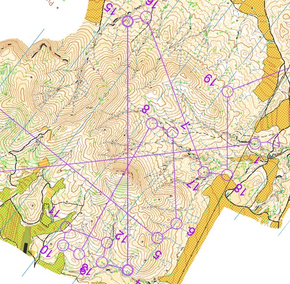
The leg (control 14 to 15) is as usually first provided without routes – you may take a look at it and think about how you would attack this leg (if the image is too small, you may click on it to get it larger). Note that you are allowed to run on the field edges, so you can plan your routechoice accordingly.
Location
You find other maps from the area in omaps.worldofo.com here. See also latest additions in 3DRerun from this area in order to learn more about this terrain type.
Webroute
Next you can draw your own route using the ‘Webroute’ below. Think through how you would attack this leg, and draw the route you would have made. Some comments about why you would choose a certain route are always nice for the other readers.
Then you can take a look at how the runners have solved this leg below.

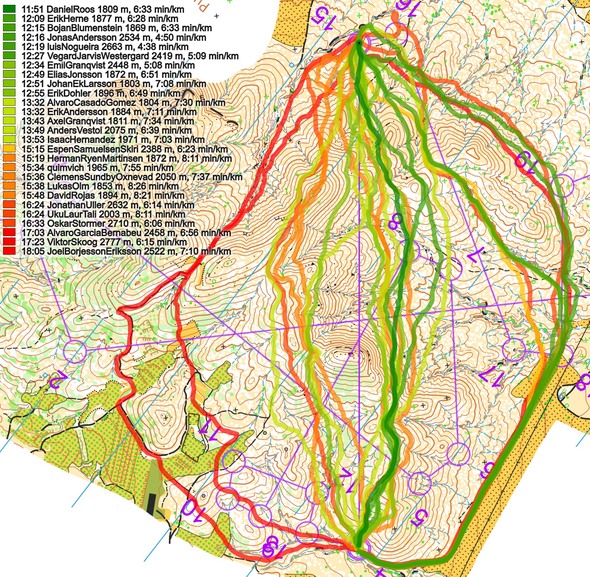
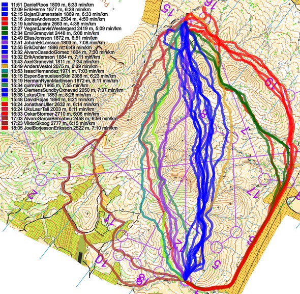
From the GPS-data it is evident that there was a wide spread in chosen routes. Two options seem to be good. The first option is to run slightly to the right of the line in the slopes of the big hills, to run as short as possible while still not climbing too much. The other option is to run far around to the right, exploiting fast running in the fields and also here reducing the climb. Straight seems to be around half a minute faster, but time differences are quite small. The alternatives are slower, though, especially running all around to the left looks to be quite a lot slower.
Density map
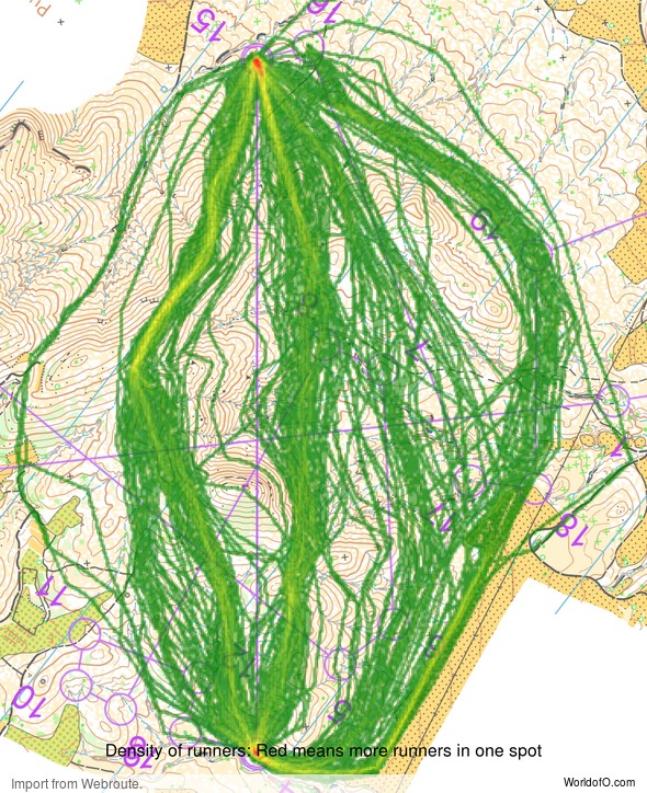
See below for a density map of some of the ones who have drawn their routes so far (available during the day when some readers have drawn their route).
Additional information
You find the complete map in omaps.worldofo.com at this location.
Route to Christmas series
The Route to Christmas series is a pre-Christmas tradition at World of O – giving the readers the opportunity to do one Route Choice Challenge each day from December 1st until December 24th. If you have got any good legs in GPSSeuranta, 3DRerun or Livelox from 2022-competitions, or old forgotten ones which are still interesting, please email me the link at Jan@Kocbach.net, and I’ll consider including it in Route to Christmas if it looks good. Route to Christmas will not be interesting if YOU don’t contribute.
Not all legs are taken for the interesting routechoice alternatives – some are also taken because the map is interesting – or because it is not straightforward to see what to do on a certain leg. Any comments are welcome – especially if you ran the event chosen for todays leg!
 World of O News


Hi Jan.
I was looking for a good NZ route choice to submit and I remembered the Ultralong earlier this year in the Castle Hill region. This map is called Hogsback and the bush on it (native nz bush) is quite slow. This long leg (10 – 12) came about halfway through the course and people took a variety of routes. Unfortunately, due to the limited field, there is not alot of gps available to analyse but it does include Matt Ogden who won JWOC back in 2012 and national team runner Joseph Lynch. The livelox is https://www.livelox.com/Viewer/Hogsback-Ultralong-Hogsback-section/Course-1?classId=521403&leg=11&tab=legView
And the winsplits is http://obasen.orientering.se/winsplits/online/en/default.asp?page=table&databaseId=84547&categoryId=1
Joe Lynch was the fastest runner on the day but he took what is likely a slower route choice up the stream and through the bush to the left, which although minimising climb, involved a lot of bush bashing. I was surprised to beat Matt on this leg (considering how much slower I was on the rest of the course!) but I think I may have taken slightly better micro route choices along the first hill and avoiding the bush going up the spur halfway through.
The conditions for this race was very cold and later in the day it started hailing and got very windy so many later starters were deterred from going along the top due to the extreme conditions up there. The valley in the bush was much more sheltered.
Obviously since there were not many routes uploaded to livelox it is hard to draw conclusions about the leg but I think it is still an interesting leg to look at.
Merry Christmas!
Felix
Thanks a lot for the tip, Felix, coming up tomorrow!
As I ran that course I can add that one of the factors causing both right-sided (southern) variants to be faster was that north sides of the hills had much more small bushes and rough vegetation while south sides was generally more open and faster. Also hilltops were more similar to north slopes and therefore staying on the ridge didn’t pay off.