Today’s leg in Route to Christmas 2023 is a long leg from the men’s class in the Danish Championships Long distance 2023. Thanks for the tip to Johan Aagaard for his annual contribution to Route to Christmas!
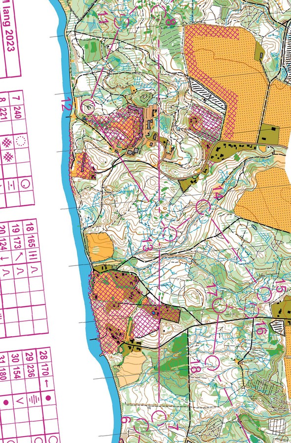
In my opinion there are especially the long leg 7-8 that are interesting, because even though there are many tracks and forbidden areas in the forest, there are actually many different route-choices at this particular leg.
The leg is as usually first provided without routes – you may take a look at it and think about how you would attack this leg (if the image is too small, you may click on it to get it larger):
Location
You find other maps from the area in omaps.worldofo.com here. See also latest additions in 3DRerun from this area in order to learn more about this terrain type.
Webroute
Next you can draw your own route using the ‘Webroute’ below. Think through how you would attack this leg, and draw the route you would have made. Some comments about why you would choose a certain route are always nice for the other readers.
Then you can take a look at how the runners have solved this leg below.
Johan provides us with some analysis here:
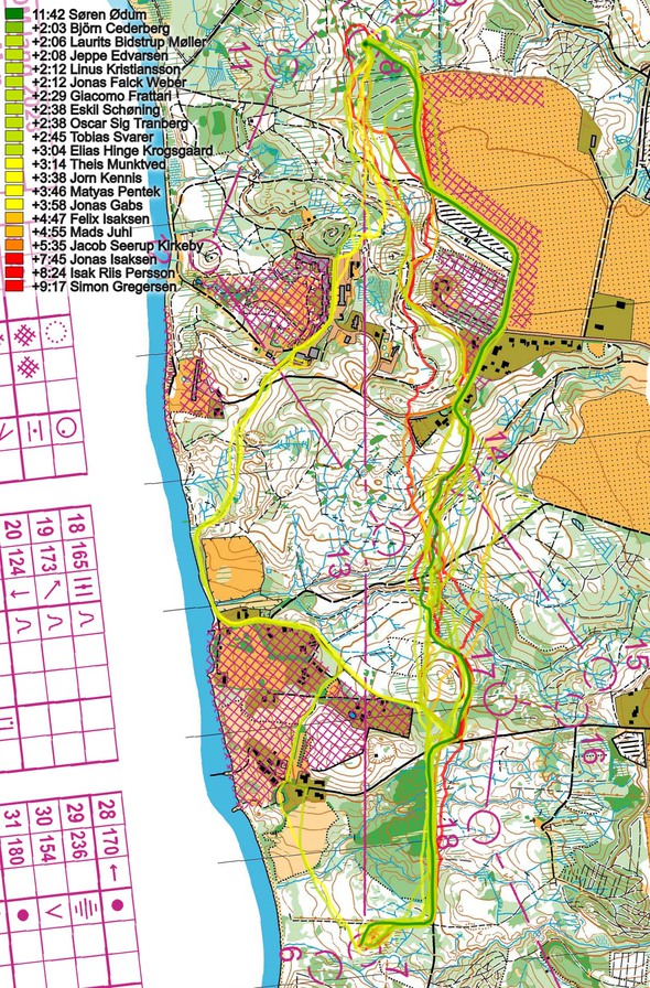
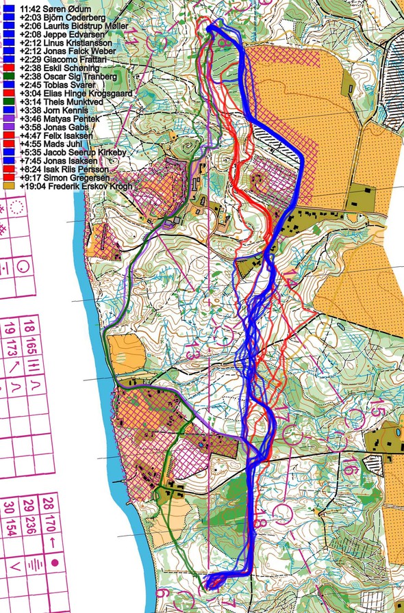
There are 3 or 4 realistic route-choices on the leg but Søren Thrane Ødum wisely chooses to use the tracks in the northern part. Even though other good runners choose the same route, Søren simply has a higher pace and by also using the small tracks he is executing better than his competitors in the middle part and allready has a clear lead halfway the leg. Søren is actually 1.19 faster than number two at the leg.
As the reigning champion Søren Thrane Ødum was the biggest favorite before the competition and he had a great start leading the competition by 38 seconds at control nr. 5. But at control number 6 he made a big mistake losing 4.30, and at control number 7 he is 3.39 after the leader and “only” number 11 in the competition. At control number 8 he is now only 2.04 behind the leader, and at the finish line Søren had a lead of 6 minutes and 19 seconds to the silver medalist, with a total of 25 legwins out of the 34 legs.
Even if Ødum has higher running speed than his competitors, it is quite clear from the comparison below that he also chooses the fastest route.
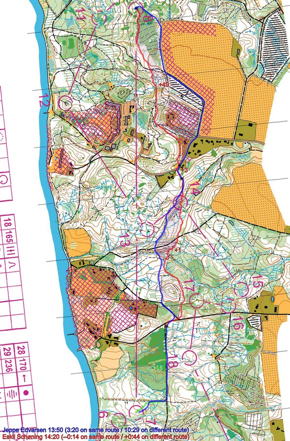
Comparing the blue and the red route, you can see that going to the right on the last part of the leg may save you nearly a minute. Going left is probably too long (so is going all the way around to the right).
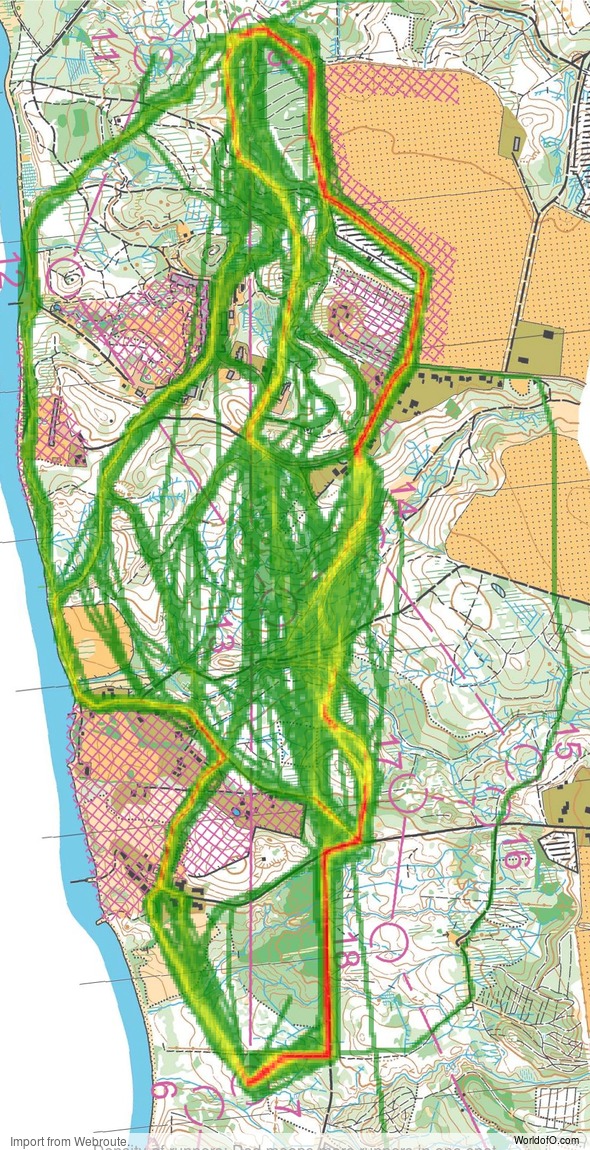
Density map
See below for a density map of some of the ones who have drawn their routes so far (available during the day when some readers have drawn their route).
Additional information
You find the complete map in omaps.worldofo.com at this location.
Route to Christmas series
The Route to Christmas series is a pre-Christmas tradition at World of O – giving the readers the opportunity to do one Route Choice Challenge each day from December 1st until December 24th. If you have got any good legs in GPSSeuranta, 3DRerun or Livelox from 2023-competitions, or old forgotten ones which are still interesting, please email me the link at Jan@Kocbach.net, and I’ll consider including it in Route to Christmas if it looks good. Route to Christmas will not be interesting if YOU don’t contribute.
Not all legs are taken for the interesting routechoice alternatives – some are also taken because the map is interesting – or because it is not straightforward to see what to do on a certain leg. Any comments are welcome – especially if you ran the event chosen for todays leg!
 World of O News


Interesting! I am not convinced though. Apparently no runner took the left alternative all the way, i.e. following the shore all the way past control 12 and then using the paths the last part (as some have drawn according to the density map). That option means less climb and the climb at the end is not steep. Should be quite fast.
That is a good point, maybe such paths along the shore are generally slow in this type of terrain. Maybe somebody familiar with the terrain can comment on it?
Could you compare times in the first part of the leg. I think going left outof the control over the yellow and between the out-of-bounds areas saves more climb than right up to the track and when you reach the valley you can switch to the right routechoice. Its a little S-shaped, but should be even faster.
HI Rolf, I actually agree it coulb be cool to compare the green and the blue route.
It is difficult to check accurately from the GPS in any way as far as I can see? Taking the left route, it is approximately equal (a few seconds faster left) to where the green (full left) and purple (first a bit right, then left) routes meet, based on the runners we have GPS for here. Thus, this does not indicate that going left out and then switching to right is faster. But tricky to know with the data we have here…