Today’s leg in Route to Christmas 2022 is a very interesting relay leg from alpine terrain in Switzerland. The leg we take a look at this time is the long leg to the 8th control in the women’s relay at the World Cup final in Davos-Klosters. Thanks again to Arild Andersen for the tip – the third tip of Arild to get into the calendar this year!
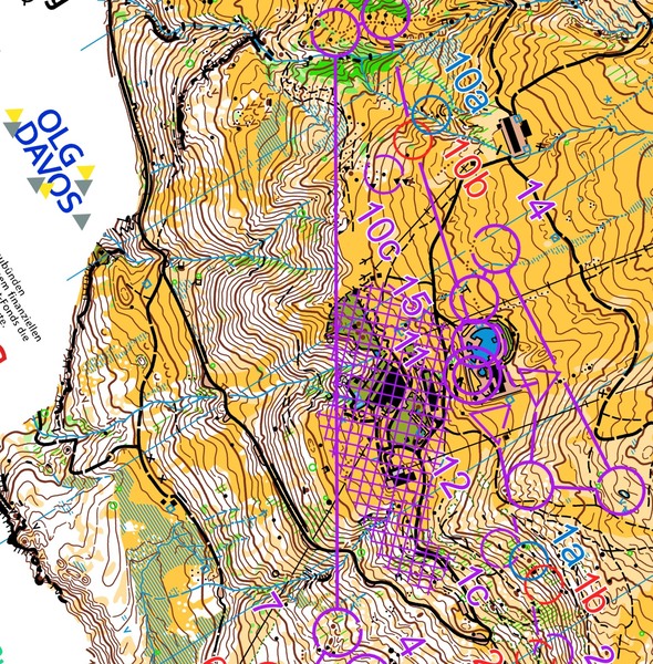
The leg is as usually first provided without routes – you may take a look at it and think about how you would attack this leg (if the image is too small, you may click on it to get it larger):
Location
You find other maps from the area in omaps.worldofo.com here. See also latest additions in 3DRerun from this area in order to learn more about this terrain type.
Webroute
Next you can draw your own route using the ‘Webroute’ below. Think through how you would attack this leg, and draw the route you would have made. Some comments about why you would choose a certain route are always nice for the other readers.
Then you can take a look at how the runners have solved this leg on the first leg below.
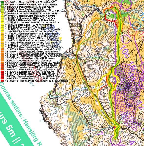
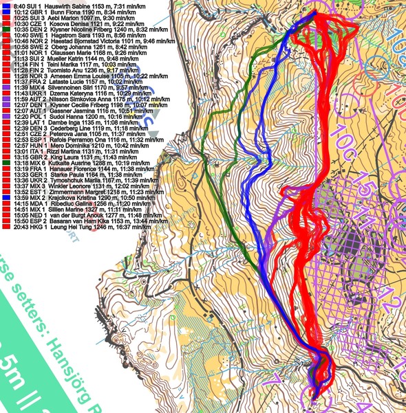
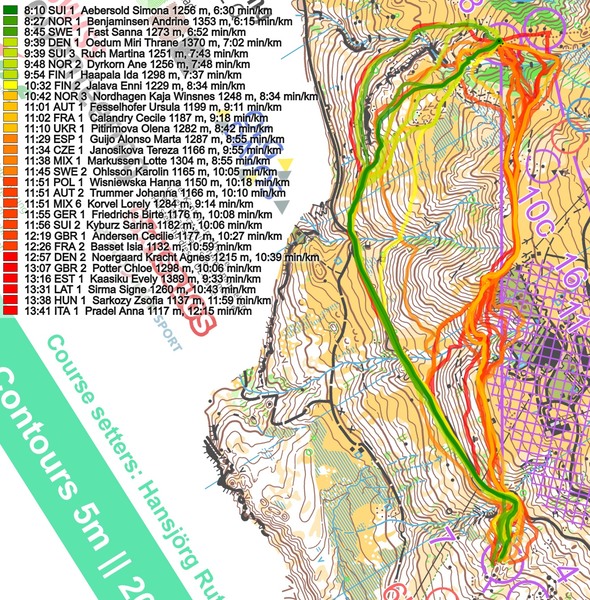
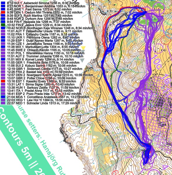
Based on the first leg it is easy to conclude that straight is fastest, but with one of the few runners running to the left (Ukskoski) being only a few seconds slower than Risby who was fastest straight, one would think that left could at least be a very good choice.
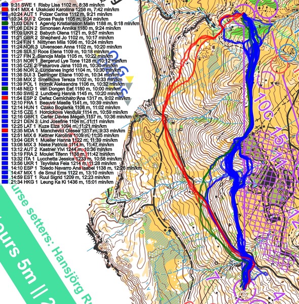
When looking at the second leg, we suddenly got some very good times on routes to the left, with the two best times run to the left, and with Hauswirth running much faster than anybody else here.
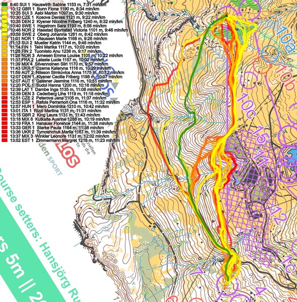
On leg three the picture is even clearer – here the 9 fastest times are run to the left, with routes going even further to the left being run very fast. The reason for straight being so much slower is that you need to partly climb very steep hillsides, and partly traverse very steep hillsides, while when going more to the right you can take the climb more gradually, and you can also exploit the road. On the flip side you have to run a bit downhill and lose some altitude, but going very steep is simply very slow…
Density map
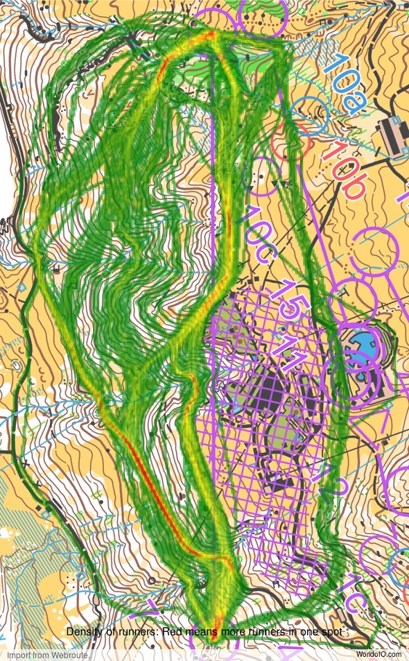
See below for a density map of some of the ones who have drawn their routes so far (available during the day when some readers have drawn their route).
Additional information
You find the complete map in omaps.worldofo.com at this location.
Route to Christmas series
The Route to Christmas series is a pre-Christmas tradition at World of O – giving the readers the opportunity to do one Route Choice Challenge each day from December 1st until December 24th. If you have got any good legs in GPSSeuranta, 3DRerun or Livelox from 2022-competitions, or old forgotten ones which are still interesting, please email me the link at Jan@Kocbach.net, and I’ll consider including it in Route to Christmas if it looks good. Route to Christmas will not be interesting if YOU don’t contribute.
Not all legs are taken for the interesting routechoice alternatives – some are also taken because the map is interesting – or because it is not straightforward to see what to do on a certain leg. Any comments are welcome – especially if you ran the event chosen for todays leg!
 World of O News


When the course planner gives the runners the opportunity to get into an out of bounds-area, then in my opinion, it is bad course planning.
Several runners, especially on the first leg ran into the out of bounds area, which was only shown on the map but not marked in the terrain. In my opininon is it a big mistake both from the course planners but also from the technical advisers.
@JL There is another perspective in which it is clearly the IOF fault, that breaches of rules are not penalized but played down. Only this year we had WC final long, JWOC Sprint and WOC Sprint Relay. Athletes running on that level should be capable to localize and avoid OOB areas by themselves respectively bear the consequences if failing.
And also EOC long !!
@gg as far as I know, those running through the OOB (aka Gernot Ymsen) where disqualified in this case. The failure in that case lied between course setter and Event Adviser somehow.
At least the OOB issue did not influence the routechoice challenge (which was a nice one, I think), but clearly the OOB area should have been marked in the terrain as it is so obvious that some may get close to it – or the course should have been set in a way were runners would not be that tempted to get close to it.