The final leg in Route to Christmas 2023 is a leg from the World Masters Championships in exciting karst-terrain in Slovakia. The chosen leg is the 6th leg from the M40 Long Final.
This is what the bulletin said about the terrain:
The Silická plateau is located between 500 and 630 m above sea level and is well known for its karst terrain and is characterised by big depressions. A great variety of rock detail such as rock fields and cliffs of height of 1 to 3 metres can be found on the slopes of depressions. In the terrain there are several ravines originating from karst terrain erosion. Runners will experience three different kinds of vegetation in the area – deciduous forest with occasional coniferous trees, where runnability and visibility is very good, semi-open or open areas with varying runnability and visibility and parts of the terrain with dense vegetation. The competitors will find it challenging to execute the right route choice in this terrain.
Our guest star for analyzing this leg today is Øystein Kvaal Østerbø who finished 3rd only 44 seconds behind the winner. Øystein is a Norwegian orienteer who has been part of the World Orienteering elite for many, many years – with lots of experience in terrains all around the world. Øystein’s tactics before the race was to avoid all dark green (if possible), as he was afraid to get stuck in the green and risk losing up to several minutes. He was also a bit worried about light green that could also be slow.
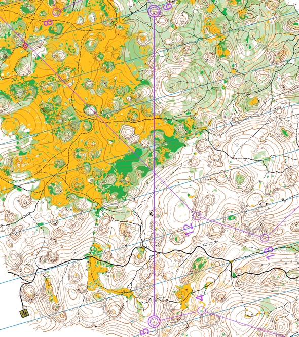
The leg is as usually first provided without routes – you may take a look at it and think about how you would attack this leg (if the image is too small, you may click on it to get it larger):
Location
You find other maps from the area in omaps.worldofo.com here. See also latest additions in 3DRerun from this area in order to learn more about this terrain type.
Webroute
Next you can draw your own route using the ‘Webroute’ below. Think through how you would attack this leg, and draw the route you would have made. Some comments about why you would choose a certain route are always nice for the other readers.
Then you can take a look at how the runners have solved this leg below.
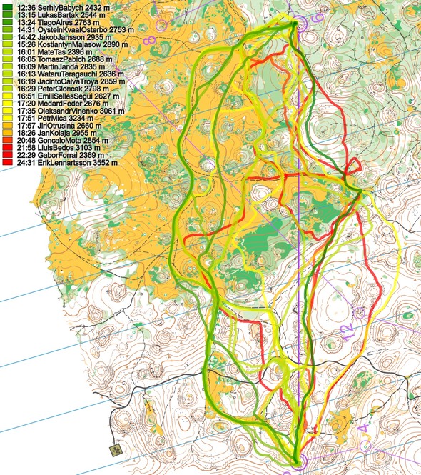
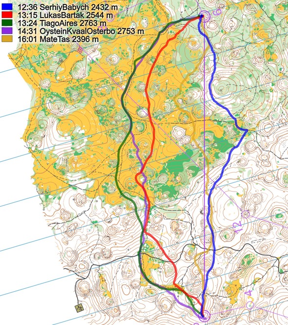
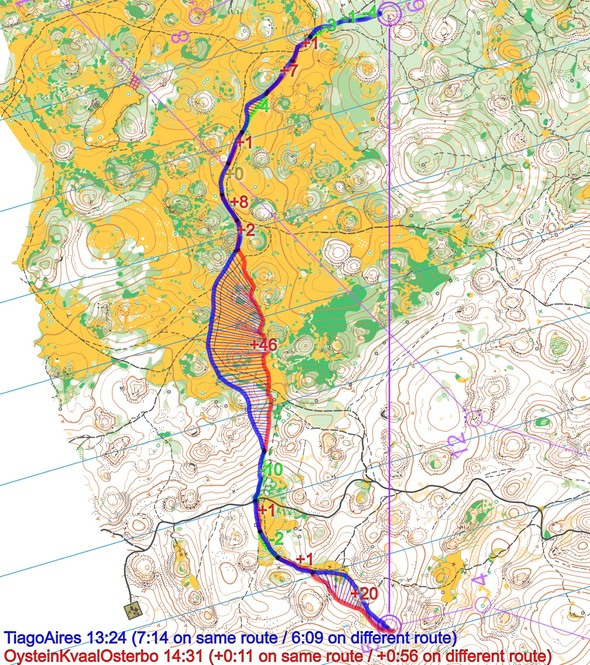
As you can see, a lot of different choices were taken – this is truly terrain where you can get the athletes to spread “all over the place” when searching for the best route choice. Here are the 5 fastest routes shown:
Here are Øystein’s thoughts about the leg (big thanks to Øystein for his analysis, highly appreciated!):
I have really good memories from this type of karst terrain after running the World University Orienteering Championships in Košice in 2006. In the Long distance I won a bronze medal in a very similar terrain, so I felt quite confident. When I saw the long leg to the 6th control I first looked for options close to the line. My tactics before the race was to avoid all dark green (if possible), so I was afraid to get stuck in the green half way on the leg, and didn’t want to risk losing up to several minutes there. The right option had the last part passing a hill with light green, that could also be slow.
So I felt left was the safest option, with big parts of the running distance on open grass areas (yellow), even if it was slightly longer. When I came to the open area the safest felt to follow the path even more left. But I decided to run a straighter line, and tried to zig-zag between the first deep depressions, even if it was some dark green there. But I got more slowed down by the green than I hoped for, and also got some extra climbing going partly down in the depressions (trying to avoid the green). So I changed back to my original plan for the last part of the open area, and went more to the left (on the path).
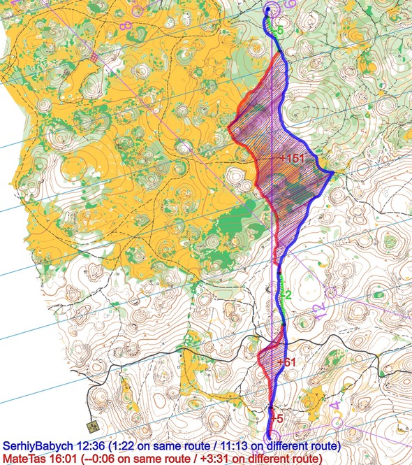
When I after the race saw the splits/routes I was surprised how much faster the right option was. But Babych found a route with almost only white forest, and also managed to get very little climb. His route is 300 m shorter than mine, and he keeps almost the same average running pace on the leg, and beat me with 1.37 (Editors comment: from the official split times; the times shown in the graphics are GPS times which are some seconds off). Bartak succeeded better on the left option, finding a shorter line than me without getting stuck in the green/depressions. Also Aires was almost one minute faster, following the path on the open area, as my original plan.
Below are some additional illustrations from this leg. A final note: The winner of the race, Esa Huttunen, was 46 seconds faster than Øystein on this leg, so with a good performance here, this could have been a gold medal for the Norwegian.
Density map
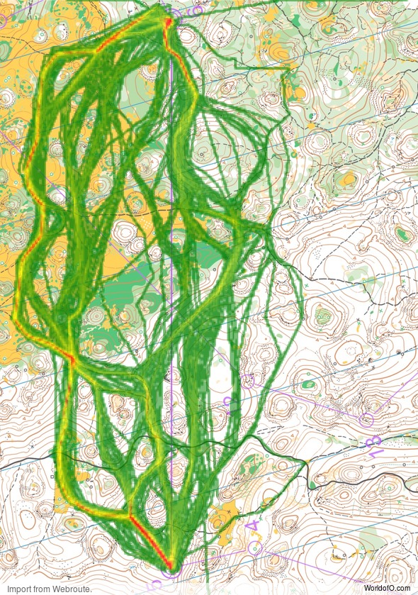
See below for a density map of some of the ones who have drawn their routes so far (available during the day when some readers have drawn their route).
Additional information
You find the complete map in omaps.worldofo.com at this location.
Route to Christmas series
The Route to Christmas series is a pre-Christmas tradition at World of O – giving the readers the opportunity to do one Route Choice Challenge each day from December 1st until December 24th. If you have got any good legs in GPSSeuranta, 3DRerun or Livelox from 2023-competitions, or old forgotten ones which are still interesting, please email me the link at Jan@Kocbach.net, and I’ll consider including it in Route to Christmas if it looks good. Route to Christmas will not be interesting if YOU don’t contribute.
Not all legs are taken for the interesting routechoice alternatives – some are also taken because the map is interesting – or because it is not straightforward to see what to do on a certain leg. Any comments are welcome – especially if you ran the event chosen for todays leg!
 World of O News
Thank you so much Jan for yet another fantastic Route to Christmas (2023)!!!!
Petr Mica has posted a video from this race, the leg from 5 to 6 can be seen here: https://www.youtube.com/watch?v=XFRbnT7EUzE&t=2037s