 World of O News
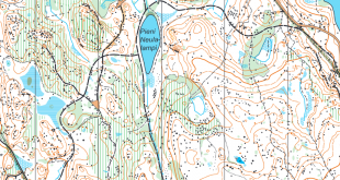
Today’s leg in Route to Christmas is the first one in the 2019-edition which comes from a sprint race. The chosen leg is from the Swedish League Sprint race in Fisksätra.
In an interview with Gustav Bergman for “Course of the Year 2019″ today, Bergman named this course the best sprint course he had been running in 2019. The leg to the second control was chosen for “Route to Christmas” because this was a quite decisive leg, with many runners taking the wrong choice. Can you understand the map fast, and make the right choice here?
Bergman says the following about this sprint: – I haven’t run that many sprints this year, but one that stands out to me is the Swedish League in Fisksätra. We are not spoiled with good sprints in Sweden, but this time we got both a good course, a good map, and a good area (but unfortunately not an especially good performance by me).
The leg is as usually first provided without routes – you may take a look at it and think about how you would attack this leg (if the image is too small, you may click on it to get it larger):
![]()
Location
You find other maps from the area in omaps.worldofo.com here. See also latest additions in 3DRerun from this area in order to learn more about this terrain type.
Webroute
Next you can draw your own route using the ‘Webroute’ below. Think through how you would attack this leg, and draw the route you would have made. Some comments about why you would choose a certain route are always nice for the other readers.
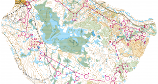
Then you can first take a look of some of the most popular/relevant routes on this leg. Did you understand the map around the bridge? The red route (A) is not that easy to see, but when drawing the routes like this it is quite clear that it has to be faster.
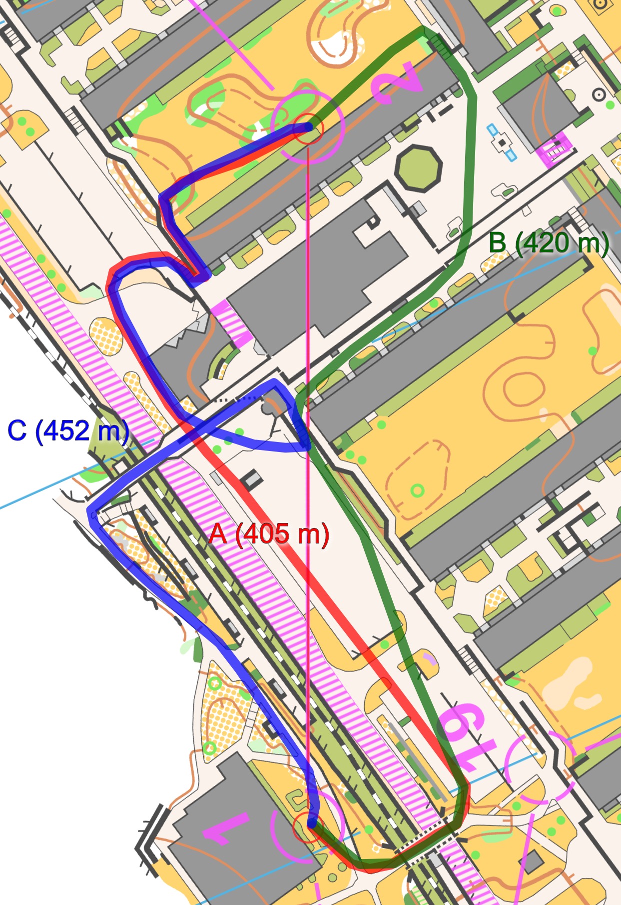
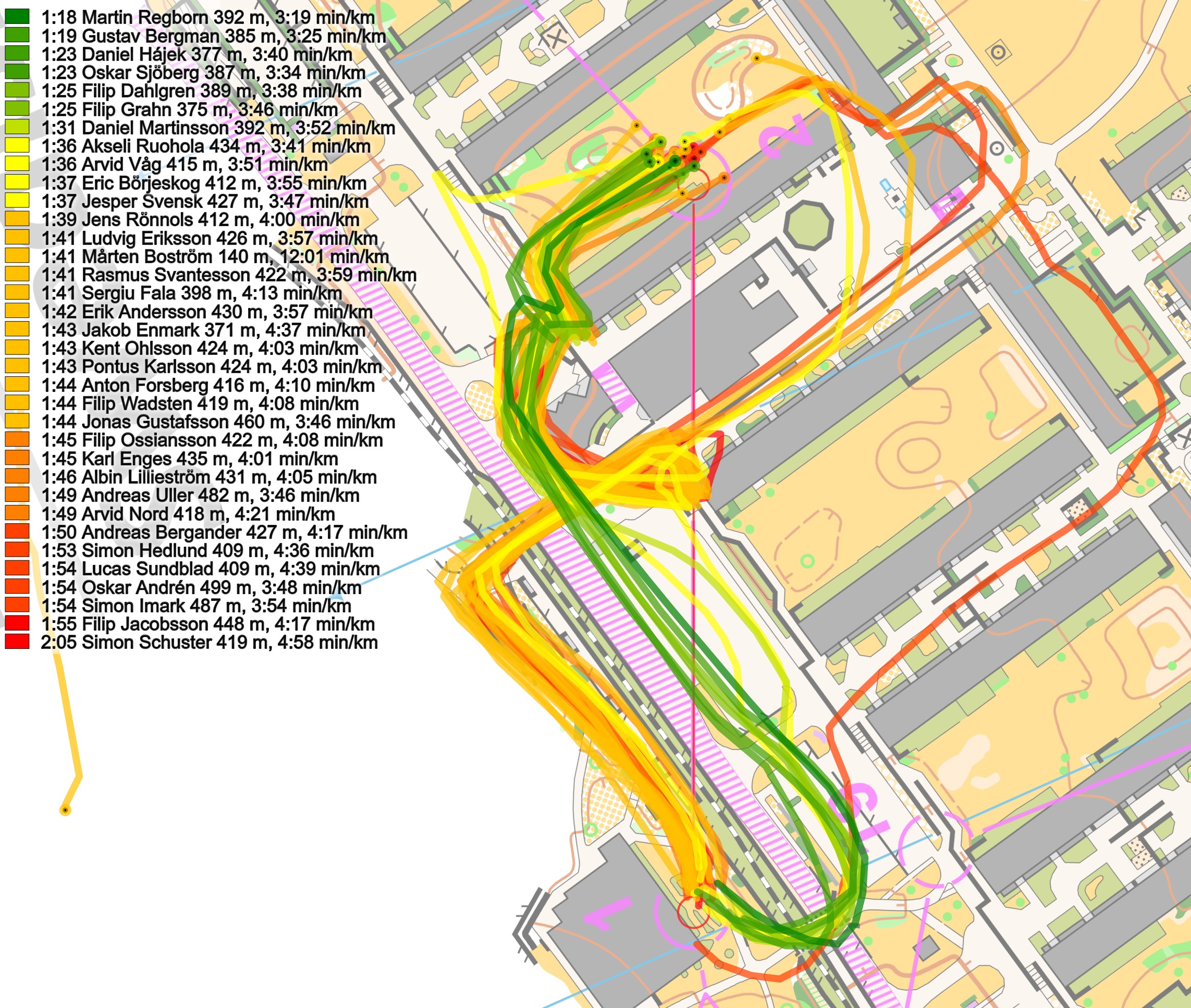
Here is a comparison of the runners on this leg (split times are from actual GPS-data). As you can see, you lose around 15-20 seconds by not running the optimal route – maybe even more.
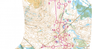
Density map
See below for a density map of some of the ones who have drawn their routes so far (available during the day when some readers have drawn their route).
![]()
Additional information
You find the complete map in omaps.worldofo.com at this location.
Route to Christmas series
The Route to Christmas series is a pre-Christmas tradition at World of O – giving the readers the opportunity to do one Route Choice Challenge each day from December 1st until December 24th. If you have got any good legs in GPSSeuranta or 3DRerun from 2019-competitions – or old forgotten ones which are still interesting – please email me the link at Jan@Kocbach.net, and I’ll include it in Route to Christmas if it looks good. Route to Christmas will not be interesting if YOU don’t contribute.
Not all legs are taken for the interesting routechoice alternatives – some are also taken because the map is interesting – or because it is not straightforward to see what to do on a certain leg. Any comments are welcome – especially if you ran the event chosen for todays leg!
Is the fastest route A (and C) under a footbridge over the railway? Route C seems to indicate that the thinner back lines each side are parapets as they went down some steps onto a terrace. If the thinner lines were crossable as drawn, why didn’t C turn left after crossing the railway? Should these lines be the thicker black uncrossable lines? The map does not show an underpass to the bridge with black dots each side, so how can you know for certain that there is a way through? Is this map actually drawn correctly?
Thanks for the comment, Peter. I would also have expected black dots on both sides to know for certain that there is a way through. I suppose that with the new ISSOM it should be easier to draw this kind of situation in an understandable way?
As map maker and course setter, I would like to give my opinion. After a lot of consideration and discussions with my map controller I decided it would be sad to not be able to use such interesting areas, and instead I wrote clearly in the bulletin how 3D-areas in general are represented and how some specific bridges and tunnels are drawn, so that it would be fair for all runners: https://eventor.orientering.se/Documents/Event/47150/3/Bulletin–2—Final-information-WRE-and-Elite-Classes (there you can also find pictures of the bridge on the route to control 2)
The bridges were definitely difficult to represent. I made them very much wider on the map than in real life, but still didn’t have space for more than one or two underpass dots, which just looked confusing instead of helpful. Instead I decided to skip underpass dots on the thin bridges (as could be seen in the bulletin), but use it at this specific bridge to clarify that there are in fact three levels (only two on top of each other). As this bridge was very special and not too easy to understand from the map either way I drew it, I decided for this solution together with my map controller and clarified it with map excerpt and pictures in the bulletin.
By the way, I am not sure that the new ISSprOM will be only helpful in these cases as the outline of a bridge will be 0,4 mm, as thick as an impassable wall or an impassable fence, which easily gives you the illusion that you should not pass it. However, I think the new multilevel symbol will help for sure.
Thanks a lot for the added information, Simon. I assumed that there was good information about this in the Bulletin (and I guess I should have included it as pre-information before asking people to solve the leg; thanks for the link).
About ISSproM: Yes, it was the multilevel-symbol I thought about.
Unfortunatly the new underpass symbol will not help a lot, since its to narrow for it. At least thats my impression. With the new bridge symbol wich takes a lot of space already (because its 0.4mm wide) you often end up with quite narrow passages. But the new ISprOM2019 has this passage as bonus: “If underpasses under bridges are to be used in a competition, they shall be emphasized
with the symbol Crossing point (710.1) or Crossing section (710.2).”