 World of O News
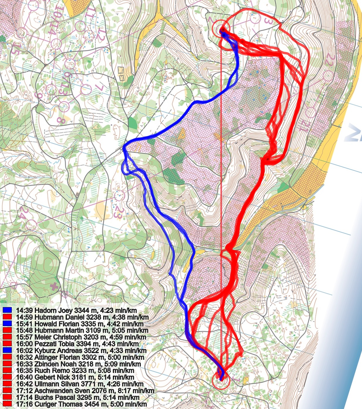
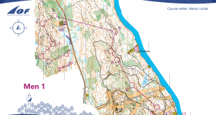
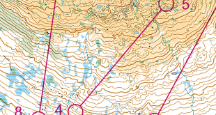
Today’s leg in Route to Christmas is a long leg from the Swiss Championships Long distance. Already early in the race the runners were met by a 2.5 km long leg in a very hilly terrain with some big valleys and many roads and paths.
As always in this kind of terrain, the question is how far you can go around to avoid climbing. In this particular case you can choose to run nearly flat by running very far around, go quite straight and take a lot of climb, or choose one of the many options in-between.
The leg is as usually first provided without routes – you may take a look at it and think about how you would attack this leg (if the image is too small, you may click on it to get it larger):
![]()
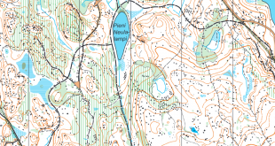
Location
You find other maps from the area in omaps.worldofo.com here. See also latest additions in 3DRerun from this area in order to learn more about this terrain type.
Webroute
Next you can draw your own route using the ‘Webroute’ below. Think through how you would attack this leg, and draw the route you would have made. Some comments about why you would choose a certain route are always nice for the other readers.
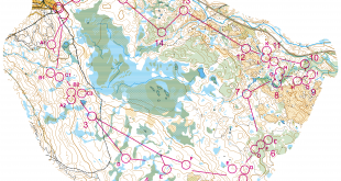
Then you can take a look at how the runners have solved this leg below. As you can see nobody chose to go all the way around on the flat (this was a good option in the women’s course where the second control was placed more to the left). Instead there were two main options – either going to the left like Joey Hadorn (fastest on the leg) or to the right like Daniel Hubmann (second fastest on the leg, losing 20 seconds). It is difficult to say which of these options is faster, but as also the third fastest time is ran to the left it seems that this may be the best option. However, when looking closer at the routes, you can see that the “micro-routechoices” are just as interesting as the main routechoice between left and right (see below the first three illustrations).

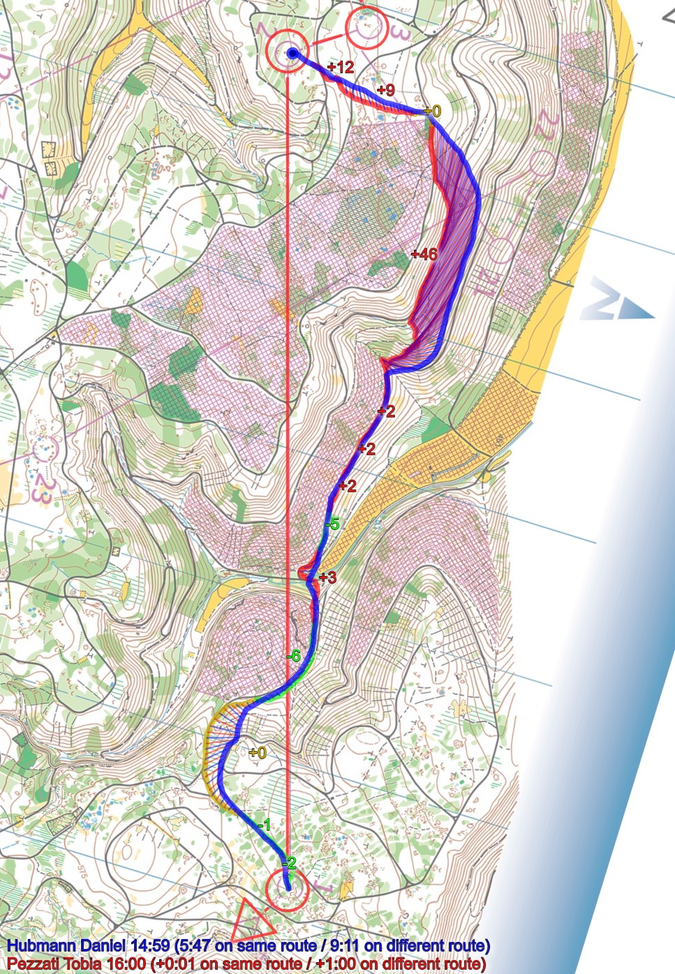
First considering the option to the right, you can see how Martin Hubmann is just as fast as his brother on most of the leg, but two choices make him lose first around 50 seconds and then around 30 seconds. Clearly these type of timelosses is what is really important to avoid in this type of terrain.

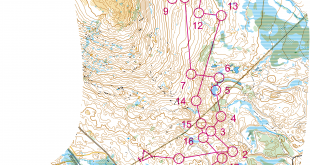
Similarly, Christian Meyer climbs too early, losing around 45 seconds. He climbs where it is steeper, and it takes more time.

Tobia Pezzatia does a similar mistake:
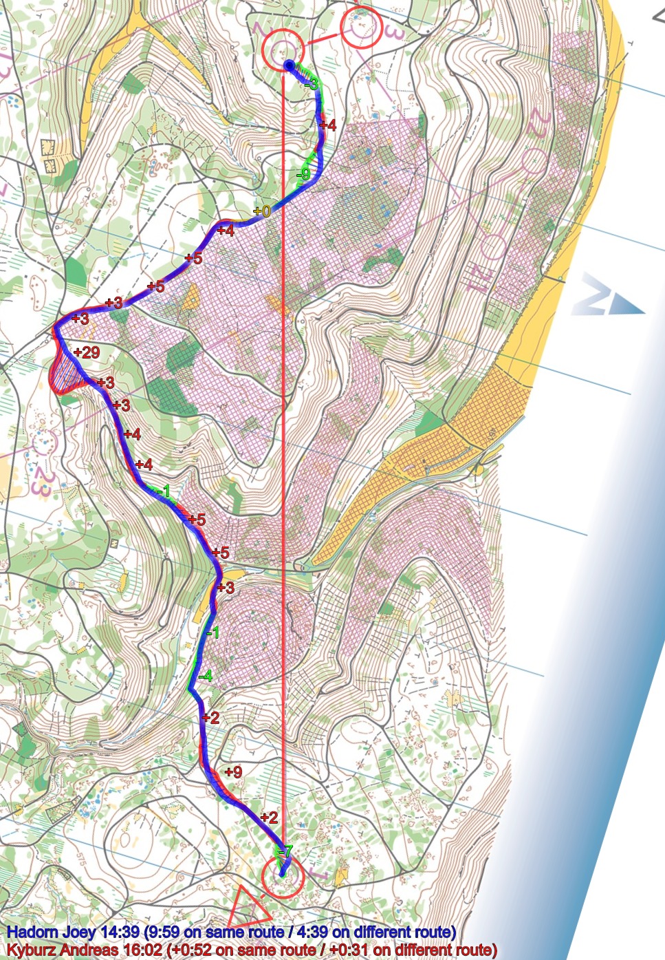
Finally on the left route there is also possibility to lose time on a “micro-routechoice” – here you can see how Andreas Kyburz loses 20-25 seconds by taking an extra small loop.
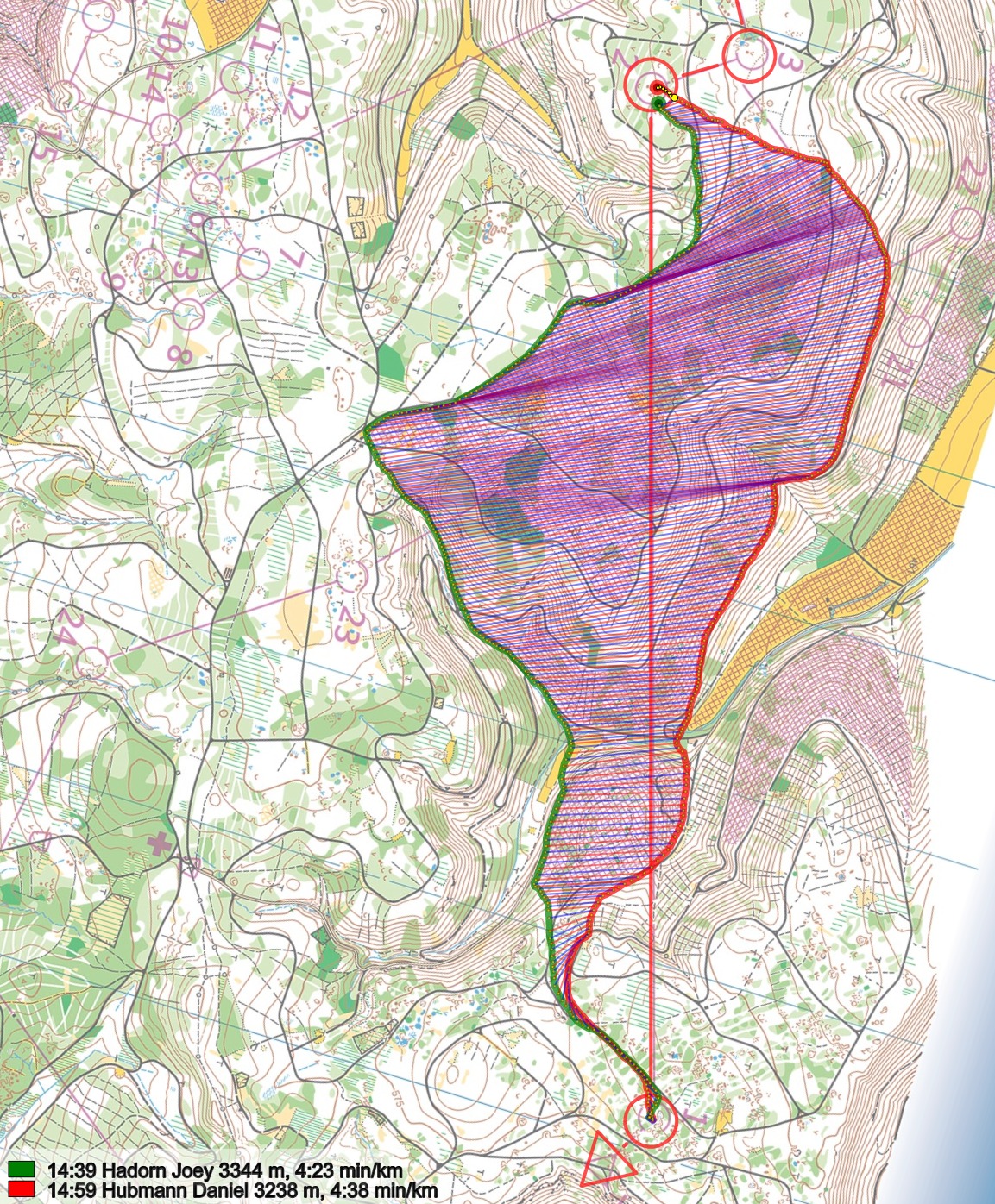
Density map
See below for a density map of some of the ones who have drawn their routes so far (available during the day when some readers have drawn their route).
![]()
Additional information
You find the complete map in omaps.worldofo.com at this location.
Route to Christmas series
The Route to Christmas series is a pre-Christmas tradition at World of O – giving the readers the opportunity to do one Route Choice Challenge each day from December 1st until December 24th. If you have got any good legs in GPSSeuranta or 3DRerun from 2019-competitions – or old forgotten ones which are still interesting – please email me the link at Jan@Kocbach.net, and I’ll include it in Route to Christmas if it looks good. Route to Christmas will not be interesting if YOU don’t contribute.
Not all legs are taken for the interesting routechoice alternatives – some are also taken because the map is interesting – or because it is not straightforward to see what to do on a certain leg. Any comments are welcome – especially if you ran the event chosen for todays leg!
I think that for almost all “normal” orienteers, going far left would have been a good option simply because you save so much energy, the fastest people here are definitely “not normal”. :-)
Looking forward to seeing the density map.Could be the first time that many people choose a route (flat to to the far left) that none of the actual competitors chose. One lesson I’ve taken from this series is that if you have a big climb to do, try to find the gentlest slope to do it.
Two points:
1) Isolated leg analysis: We can not know if there is a strategic thought behind the variant of Pezzati which could be to spend the time in the steep slope to prepare the further course. That way we would have external elements influencing the analysis.
2) We need more re-runs. Francois et Baptiste. It would be veeery interesting to have Joey and Daniel switch routes. What if Joey is even faster on Daniels original route?
@o-zeugs:
1) It is not only Pezzati losing time in this steep uphill, same pattern also for other runners. So I think the timeloss is mainly due to taking the hill in the steepest place instead of in a more gradual slope (which we see again and again in this type of terrain). At least that is my interpretation, which might be wrong, though.
2) Reruns wouldn’t tell all of the story either, of course. I think on this particular leg there is probably not so much difference between the two main routes (left/right) as long as you execute well, but executing well is not that easy ….
I was losing some of the time also because in the valley where I deviated from Dani’s route I actually wanted to first go up the small path, but it got greener and greener, almost impassable, so I had to turn back to the big path and go up in the slope beside it. Of course I didn’t lose the whole time because of that, but maybe some 20″. And as far as I remember Christoph Meier also went up a bit the small path, but I am not sure.