 World of O News
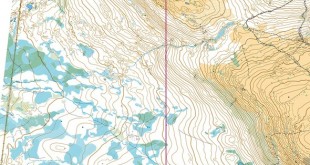
See this years Jukola map in 3D in Google Earth, and fly through the course of Matthias Merz. A video recording of the flythrough is also included for those of you who do not have Google Earth installed. Unfortunately the satellite map quality and the height information in Google Earth is not very …
About Jan Kocbach
Related Articles


Check Also
Route to Christmas: Day 24 2025
Today’s leg in Route to Christmas 2025 is a long leg from one of the ...
Hi All Experts,
Does anyone use google earth images as ground image planes for use in aerial scenes. I know how to stitch them together but are there any tools or tricks to make sure that the images are at the same height, angle and such to make sure they stitch well. I know in the pro version you can get bigger images but im not going to pay for the pro version when i could stitch multiple images together…