 World of O News
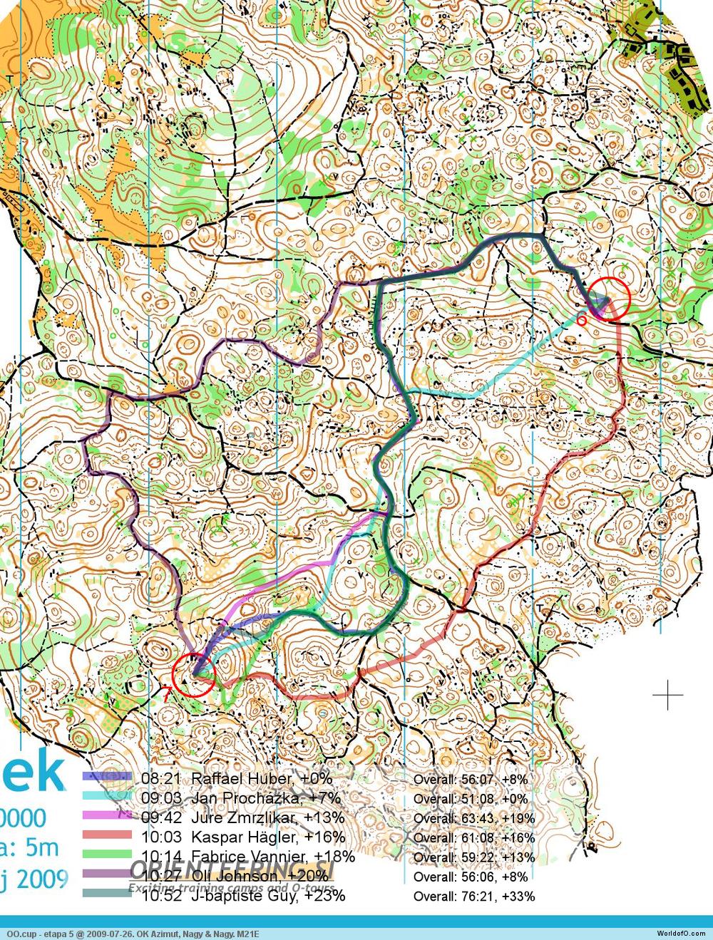
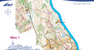
We have got one of the highlights in this years Route to Christmas today – Karst terrain from Slovenia with comments from several of the runners and the route planner. Todays leg is leg number 7 in the M21E course from the last event in OO.cup 2009 on July 26th.
We have been so lucky to get the course setter Ivan Nagy to give an introduction to the terrain – in order to let you get some background info for choosing the optimal route for this leg.
– The last two stages of OO.cup/09 were held on terrain of Ženček, which I consider a “moderate karst” area – by moderate I mean it is very interesting but not one of those super-intricate areas which are hard to find, hard to map, hard to get to, but easy to plan courses on. The runnability on Ženček is rather low – for most of us at least. This is due to very (sometimes extremely) rocky ground in some parts of the map combined with cut branches and sometimes patches of low vegetation. At places it gets really messy and you can’t really know what to expect because not all the micro vegetation can be shown on the map and too much of black colour would severly hinder the map
legibility. The white coulour is often on the edge of first green. Small footpaths paths are normally well visible but can be slightly overgrown. I think only the hardcore terrain runners can feel really comfortable choosing the straight routes on Ženček (throughout the whole race), but if you are really strong (and a little bit crazy) it can pay off.
The leg is as usually first provided without routes – you may take a look at it and think about how you would attack this leg (if the image is too small, you may click on it to get it larger):
![]()
Webroute
Next you can draw your own route using the ‘Webroute’ below. Think through how you would attack this leg, and draw the route you would have made. Some comments about why you would choose a certain route are always nice for the other readers.
Then you can take a look at how the runners who have drawn their route choice solved this leg. Some comments about the leg from some of the runners:
- Raffael Huber had the best time on the leg, running in S-shape (blue). – At stage 4 and 5 the big paths were usually fast and in parts the ground was very stony. Because we had controls in the same area as control number 7 the day before, i tried to find a route taking me close to the control on a big path, since this area was the most shreddering of the whole map. My teammate always tell that I’m a fast runner but can not read the map – so it was a good decision;+) To be serious i think Jure Zmrzlikar took the best route.
- Jan Prochazka won the race this day, but was surprised to loose 40 seconds to Raffael Huber on this leg (light blue route). – It was nice and extremely stony terrain. I did try to use roads as much as possible, because it was usually faster. I did run straight the leg to the seventh control, because I did not see any other option. I was really surprised, when I checked the splits and saw that I was beaten with 40s. Oocup was maybe the best terrain I did run this year.
- The route in purple by Oli Johnson going all the way around to the north-west seems to be a long detour – but still he only looses about 1.20 to Jan Prochazka on the leg. – It had been that kind of week at the OO.cup, and I thought that I would go for a completely radical round route on this long leg to see if it worked out… It didn’t, but I think you will agree that it was an interesting experiment, Oli comments on his routechoice.
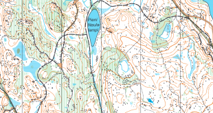
About Mapping Karst terrain
Mapping Karst terrain like the one above is a difficult task. In that regard, I got a few interesting map samples of new and old map samples of terrain which are planned to be used for the 2011 OO.Cup race (thanks to Ivan Nagy for map samples which I was allowed to post here).
- The difference in mapping style is interesting to note. The leftmost map samples is from the older map (less details, made by Cesare Tarabocchia, Italy, latest version 2008)
- The rightmost from the newer map (more details, first two map samples by Zdenek Sokolar, the last sample by Jan Drbal, Czech Republic, November 2009).
Some prefer the mapping style of the old map which is easier to read in high speed – others (me included) prefer the mapping style of the new map which gives a lot more details for the fine-orienteering. Which one do you like better?

Complete map in Omaps.worldofo.com
You find the complete map and Routegadget info in omaps.worldofo.com at this location.
Omaps.worldofo.com
The ‘Route to Christmas’ series at World of O was very popular the two last year – and I’ve therefore decided to continue the series this Christmas as well. If you have got any good legs in RouteGadget from 2009-competitions – or old forgotten ones which are still interesting – please email me the link at Jan@Kocbach.net, and I’ll include it in Route to Christmas if it looks good. Route to Christmas will not be interesting if YOU don’t contribute.
There will be no analysis about the best routechoice for each leg – you can provide that yourself in the comments or in the Webroute. Not all legs are taken for the interesting routechoice alternatives – some are also taken because the map is interesting – or because it is not straightforward to see what to do on a certain leg. Any comments are welcome – especially if you ran the event chosen for todays leg!
Note that there may be some errors in the Routegadget data (sometimes somebody draws a route for another runner just for fun). Please add a comment below if you spot en error.
Disclaimer: OO.Cup was one of the sponsors in Orienteering Achievement of 2009. The choice of OO.Cup for Route to Christmas is however done solely on editorial basis, and is not influenced by OO.Cup being a sponsor for other activities.
Old-style mapping is definitely better. It doesn’t contain most of details unneeded for fast orienteering. And with old-style mapping you definitely know that all the details in the map will be clearly seen also in the terrain. With the new-style not all details shown on map can always be clearly seen in the terrain.
@Renchix: I like the new style, as in this type of terrain, I really need to do a lot of fine orienteering when being close to the control in order to find the controls without error. I’ve had much better feeling when orienteering on maps of the new style than on maps with the old style in Slovenia. I think it is part of the modern orienteering technique to manage to draw the important details out of a map drawn with the new style.
As I see it, the old style maps work well until runner makes a mistake. Once you have to relocate, the new map works better and is more fair. The biggest challenge for detailed style mappers is to make the map readable. Orienteers themselves should be able to simplify the contours on their route.
I like the old style, cause I got a bottle of home-made wine from Cesare 3 years ago after running on one of his maps:)
New maps are clearly too detailed – mapmakers haven’t been able to see the terrain from a viewpoint of a runner. They have too good basemaps or just too much time!
In the sixties when first good o-maps appeared, it was said that: “finally we’ve got maps made to orienteers by orienteers”. Now we’re moving away from this again:(
Markus >> I would like to ask you a question? Does a very good mapper understand the orienteering technique of some of the worlds best orienteers? Do you think that it is possible to simplify a map the same way as any orienteer would do?
Of cause it is not possible to simplify as any runner would do, and I really doubt that all mappers understand how elite orienteers navigate. In my opinion, you cannot change the terrain. The task of the mapper is to represent this as perfect as possible, but of cause this will never be completly perfect. The task of the runner is then to choose the information he or she needs for his navigation. But this is ONLY the task of the runner, not the mapper.
If you look closer on the second sample you see that the amount of new details is not that big. The main difference is the use of help contours. In my opinion the use of help contours is excessive. Some of the help contours just lay between normal contours and add no new information.
Since I know this terrain very well, I can say that, IMHU, both mapping styles have a problem: in the old map, some details are drown not so precisely, for example you can see that depressions and hills are too rounded, and this makes very difficult to relocate. In the newer version, I agree with Ales, the use of help contours is excessive, and sometimes it doesn’t give any additional information.
Then, I see a difference in the number of details too. The new mapper puts many more of rocks, boulders etc. so I wonder which should be the spirit of our sport. Is it being fast on the terrain and finding the better way, or being able to find controls hidden in the middle of a maze of details without loosing precoius seconds? If you see old maps, surely orienteering was born with the first goal, but now it has evolved, and we have middle distance too. Maybe it is time to define different mapping styles for middle and long distance? What do you think about that?
My guess is that the “best” is between the two types. It seems that the details are a bit rough drawn on the old map but I agree with Ales and Andrea that the use of help contours is excessive. If you have 5 m contours then stick to it. If you don’t like that then change the countour interval to 2.5 m and use real countours instead. Orienteers should be able to ignore contour details less that the interval – even when getting lost :-)
Lars, I don’t quite agree with you. It is not the mappers task to squeeze as much information into the map as possible, as you seem to suggest. It is the mappers task to make a precise, readable – also in high speed – map which is consistent in it’s choice of features included and excluded. The latter is the hard part of mapping. Oh, and the map should of course follow ISOM…
Karst terrain is specific terrain. And not everyone is able to do a good map there. Maps on the left comes from 2008. But customer asked to survey the terrain next year completely again! So, what it means? He was not satisfied with the map. If I compare the examples there are lot of differences especialy of the shape of the contours (well, rock features too). Nothing personal against Italian mapper C.T. but Czech guys put to the map much more effort and their technic skills. My strong opinion is that maps on the right side are much more exact and you can navigate pretty well with them. A map must be exact otherwise it is not a map but a picture! It is necessary to say that I agree with you, Ales and the others, that the use of help contours is really excessive. So, let’s use less help contours and maps on right side are good. I believe that maps on right side are more precise and features are located more exact. Did you try anytime to make a revision of rough and not exact map? Comment to Markus: Sorry, I have never seen that any mapper has too much time to do the map! Jiri Danek, orienteering mapper
to Lars: I wasn’t pointing to understanding the technique of some of the best orienteers, nor to the worst. I was just pointing to a very important document called ISOM which states the same (in different words).