 World of O News
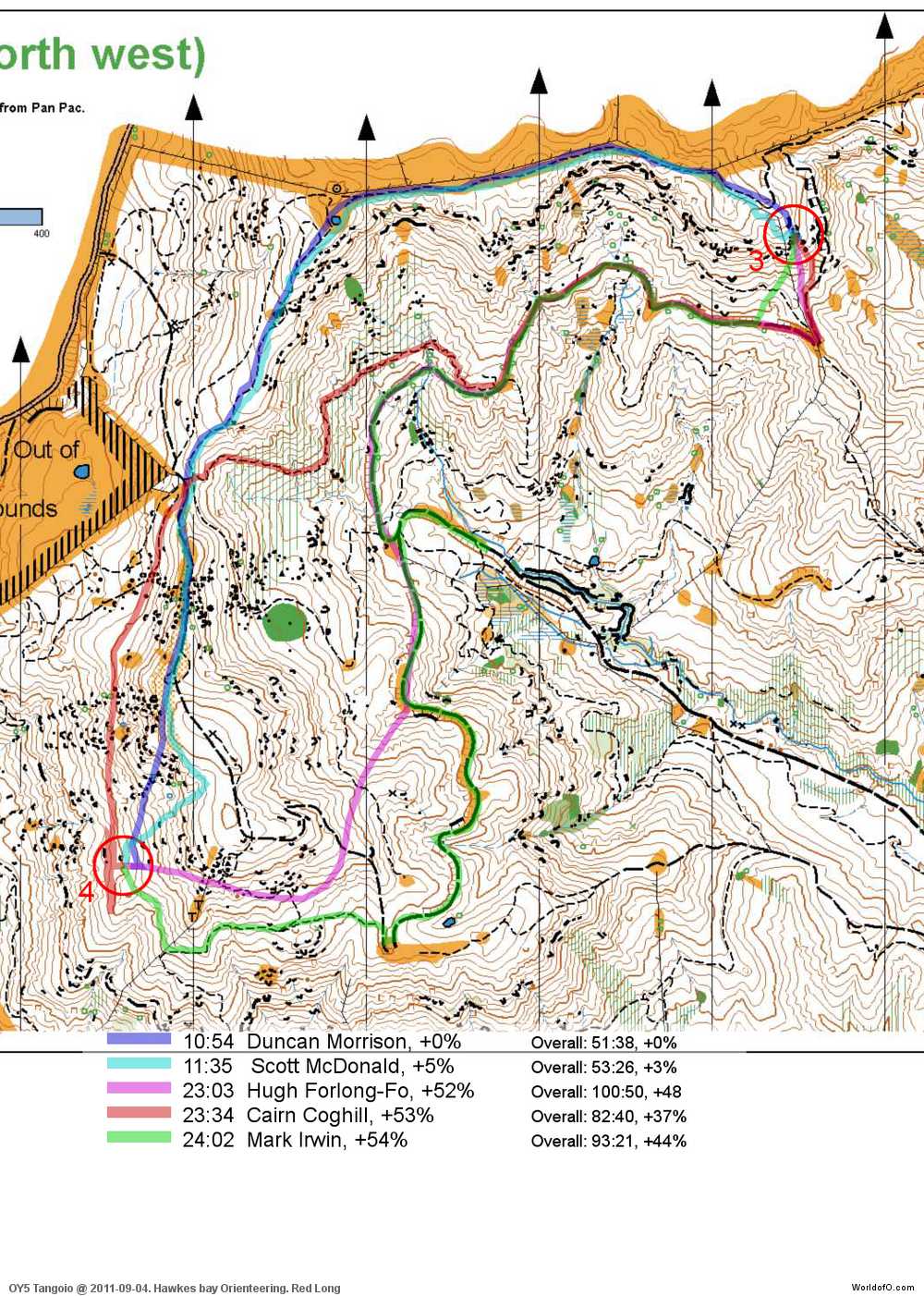
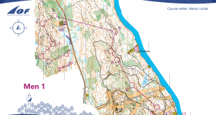
In today’s edition of Route to Christmas we travel all the way over to New Zealand again. This time we are at the Northern Island close to Hawkes Bay.
The terrain is quite complex with a lot of contours which are not straight forward to understand – and several paths making this an interesting place for longer route choices legs. The chosen leg is leg number 4 – a long one with several options. The leg is as usually first provided without routes – you may take a look at it and think about how you would attack this leg (if the image is too small, you may click on it to get it larger):
![]()
Webroute
Next you can draw your own route using the ‘Webroute’ below. Think through how you would attack this leg, and draw the route you would have made. Some comments about why you would choose a certain route are always nice for the other readers.
Then you can take a look at how the runners who have drawn their route choice solved this leg.
As you can see, the quality of the runners who have drawn their route varies greatly. Both of the two fast finishers have chosen the same route – going north. This is probably also the best choice as the other alternatives takes you through several S-shaped turns along the way – and you also loose a lot of height.
Complete map in Omaps.worldofo.com
You find the complete map and Routegadget info in omaps.worldofo.com at this location.
Omaps.worldofo.com
The ‘Route to Christmas’ series at World of O has been very popular the last years – and I’ve therefore decided to continue the series this Christmas as well. If you have got any good legs in RouteGadget from 2011-competitions – or old forgotten ones which are still interesting – please email me the link at Jan@Kocbach.net, and I’ll include it in Route to Christmas if it looks good. Route to Christmas will not be interesting if YOU don’t contribute.
There will be no analysis about the best routechoice for each leg – you can provide that yourself in the comments or in the Webroute. Not all legs are taken for the interesting routechoice alternatives – some are also taken because the map is interesting – or because it is not straightforward to see what to do on a certain leg. Any comments are welcome – especially if you ran the event chosen for todays leg!
Note that there may be some errors in the Routegadget data (sometimes somebody draws a route for another runner just for fun). Please add a comment below if you spot en error.
What happened to the density maps? They were really good.
Somebody decided to spam the route drawings with obscene drawings, and it therefore was too much work to remove the routes with problems. I might look into it after Christmas, quite a few are probably good to go…
Where are the sprint legs?
I did not get any good tips about sprint legs, and could not find any good myself either. If you have some tips, please send me, and I might make a bonus leg!
heres a good sprint for you!
http://oawa.pdowling.id.au/cgi-bin/reitti.cgi?act=map&id=105&&kieli=
can get more routes drawn if you like.
Thanks a lot! I also got a few suggestions by email, and I am sure I can make one or two bonus legs from these! If you get more people to draw routes, it increases the chance that I will choose it.I can not take a look at the legs until in a few days as I have no internet where I am just now except on mobile.
How about leg 8 on this course http://www.kokkolansuunnistajat.fi/cgi-bin/gadget/reitti.cgi?act=map&id=119&kieli=
All the three main route choices are in the reittihärveli. Results can be found here http://www.kokkolansuunnistajat.fi/?sivu=kilpailut/2011/asuntomessusprintti/index.php
It was in the middle of summer and the grass was quite high on certain areas of the middle route choice. The path on the northern route choice was cleared so that it would be as fast as it looked on the map.
The H21 course…
I think it was a very good course if you take into consideration that the area was quite simple.