 World of O News

– A part of the map used at 25-manna this year is an example of a poor legible map. Unfortunately there are quite a few other examples out there, Tore Sandvik comments in this article. One of Sandvik’s main points is that although laser scanned base maps is a revolution for accuracy – it makes it more difficult for mappers to draw good legible maps.
Sandvik is known as an engineer in cartography with a fine orienteering career: WOC gold in relay from Inverness in 1999, WOC silver in middle from Tampere in 2001 – and a lot of 10Mila victories with Halden. Sandvik has also a fair bit of experience as a mapper. The following article is based on several e-mails from Sandvik.
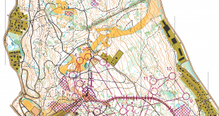
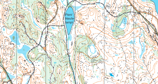
The 25manna map
The map is drawn using too small symbols and too small gaps between symbols
The illustration at the top of the page shows part of the 25manna map to the left, and the same part redrawn by Sandvik to the right.
– For fun, I redrew a part of the 25-manna map, Sandvik says about the map to the right. – I didn’t bother to draw the green and yellow though, as I decided to focus mainly on the brown in order to show a better legible map than the original by using the ISOM2000. Of course, this was just an highly experimental exercise and a bit unfair to the mapper.
The point Sandvik tries to make here is that the original map is not drawn according to ISOM2000 (the international standard for orienteering maps). The map is drawn using too small symbols and too small gaps between symbols. The minimum symbol and gap dimensions are given in the ISOM2000, and the ISOM2000 emphasizes the importance of legibility. Nevertheless, these rules seems to be difficult to follow for (some) mappers, according to Sandvik.
Laser base maps often results in excessive use of form lines, numerous and too small brown details
– Laser scanned base maps clearly is a revolution for accuracy and for simplifying surveying. Paradoxically tough, it tends to make it more difficult for mappers to draw good legible maps. Especially to draw a good legible contour image seems to be a big challenge for many mappers. Laser base maps often results in excessive use of form lines, numerous and too small brown details, Sandvik says.
– I guess mappers (and orienteers?) want details more than good legibility, quite the opposite of what the ISOM2000 says!
Non-ISOM2000 symbol set with small symbols in Sweden
This symbol set includes some extra 70% – sized symbols for many point features
According to Sandvik, there seems to exist a commonly used OCAD symbol set in Sweden that is deviant from the ISOM2000 and even from the official Swedish ISOM2000 variant.
– This symbol set was apparently used on all the (ISOM) 2013 Swedish Championships maps, Sandvik comments.
– This symbol set includes some extra 70% – sized symbols for many point features. On the 25-manna map you can see those symbols as “mini” small knolls or “mini” elongated knolls.
– Artistic exercise of mapping
Generalization is not easy – especially not with all the details available with laser scanned base maps. Good generalization is an art, according to Sandvik.
– About generalization; I would like to call this the greatest artistic exercise of mapping, Sandvik says.
– It is not important how many details you can put on the map – it’s all about putting enough of the important details. A lesson to learn from generalization can be found here (in Norwegian).
This does the ISOM2000 say
The demand for legibility must never be relaxed in order to present an excess of small details and features on the map
Below Sandvik has collected some key points from ISOM2000 related to the issues discussed above.
- About generalization and legibility:
Selective generalization is the decision as to which details and features should be presented on the map. Two important considerations contribute to this decision; the importance of the feature from the runners’ point of view and its influence on the legibility of the map. These two considerations will sometimes be incompatible, but the demand for legibility must never be relaxed in order to present an excess of small details and features on the map. Therefore it will be necessary at the survey stage to adopt minimum sizes for many types of detail. These minimum sizes may vary somewhat from one map to another according to the amount of detail in question. However, consistency is one of the most important qualities of the orienteering map. (…)-[Details are important, but legibility is most important, Sandvik comments]
- About the smallest gap between two lines of the same colour:
The gap between two fine lines of the same colour, in brown or black: 0.15mm(1:15000)
– At scale 1:10000 the minimum gap is (150% larger) 0.225mm - About the smallest bend in a contour:
101 Contour; The smallest bend in a contour is 0.25 mm (1:15000) from centre to centre of the lines.
– At scale 1:10000 the smallest bend is (150% larger) 0.375mm.
- About 112 Small knoll and 113 elongated small knoll
The symbol may not touch a contour line.
What do YOU think?
What do you think about the issue brought up by Sandvik here? These discussions are coming up more and more often as the base map material gets improved. Sandvik discussed the Swedish practice in particular – but we saw similar issues with regards to the WOC maps in France in 2011 and with many other mapping projects. There seems to be a “fight” between the camp of mappers/orienteers who want as many details as possible on the map – and the “generalization camp”. The latter is fronted by the map committee of the IOF – which is also responsible for ISOM.
Sandik’s question to the readers is what we should do to get better legible maps in the future. Do we need a better control system? More detailed instructions and follow-up for mappers? Some kind of built-in ISOM-control in OCAD? And for Sweden specifically: A new OCAD symbol set that is in accordance with the ISOM2000?
It seems that here the mapper first and then the map controller did not do his job properly. The controller should have refused the map due to frequently defaulting against the minimal gap rules (which are to be held between all objects of the same color, not only lines as written in the article) and due the the excessive and unforced use of map symbols declared “only for exceptional cases”. He probably did not do that for both points are absent in the map controllers protocol of the swedish orienteering federation http://www.orientering.se/Arrangor/Kartfragor/Atttaframenkarta/Kvalitetssakringavtavlingskarta/ …
To answer Tore Sandviks question: The national federations should guarantee the compliance with the mapping norms by qualifying map controllers which are ripe to support non-professionals and even more to deal with professionals (what i mean with that you can see on this map http://jec2013.files.wordpress.com/2013/10/jec2013ld_m20.gif ).
Good examples: map which are not done for orienteering and not used ISOM2000. Tore’s more readable version for orienteering. Legibility has to be selection if you have “too much” information to publish. Need to think – which elements are the most important and which elements you can remove if it’s not readable. Shape accuracy is nice goal, but legibility is more important.
103 form line is not so easy method in the small knolls. Many of the mappers use in this point special form line to offer more readable knolls. Cutting is less than 0.25. Too narrow is also not so easy to read. Adding little extra width give more legibility.
Legibility on the printed map in the correct scale is answer, not zooming on the display.
Do we need a better control system?
++++++++++++++++++++++++++++++++++
Can you point on document how the IOF control system works now within a current ISOM and say in which particular part of this process things go wrong? It seems that the map commission need first to adopt new ISOM and than starting to think about new control system….Map commission could be more merciful to WRE organizers as they’ve banned only maps/competitions with the wrong map scale. It would be interesting to see the whole list of banned WRE competitions and what was their reason.
More detailed instructions and follow-up for mappers?
+++++++++++++++++++++++++++++++++++++++++++++++++++++
Make it online, by category. Live/open discussion. Each mapper should be able to add his examples/which OCAD symbol set he uses and explains the reasons why he used a non OCAD symbols, etc. Each runner should have access to register and comment/ask questions about the map. IOF map commission should be able to post a public statement for each example as part of their interest to make a wider public follow-up. Can they educate – online? They should check Udemy or similar platform.
Some kind of built-in ISOM-control in OCAD?
+++++++++++++++++++++++++++++++++++++++++++
That would help but police controlled system can’t work if the rules are not clear. With “built-in feature in OCAD” organizers should be able to put in bulletin the key information about the map deviations from OCAD as part of the official competition information. I would love to see that mappers prepare this (which set they use, why, reason, etc) as part of their contract with the organizers. I don’t see any logical reason why mappers should be against this practice. I assume that they want to make OCAD maps, get feedback from runners, etc. We just need to empower mappers and ask them to help to built the system which would be beneficial to them, to organizers and to runners and not only for IOF map commission. With “built-in feature in OCAD” we would only stimulate controlling and giving the power to controllers.
To clarify about the ISOM control in OCAD; what I was having in mind was more an ISOM “check” rather than “control”. See it as a tool merely for the mapper to 1) make him/her aware of symbols that are not in accordance to the current ISOM standard, and 2) locate the ISOM (or ISSOM) errors in the map (like a topology check), f.ex minimum gap/bend errors.
One point more about mapping in Sweden https://www.facebook.com/photo.php?fbid=735209779828488&set=a.180287198654085.49663
Do we see a conflict between a Nordic view of mapping and a continental? Isn’t it much more common with seriously detailed and packed maps in the Czech Republic, France, Hungary than in, say, Finland?
And the next question: is the traditional Nordic view still the best and only valid view?
@Thibault: As I understand this, the main issue here is that the rules set in ISOM are not followed. This is not about the Nordic view, but rather about rules which are set up in order to secure legible maps.
Personally, I would want more detailed maps (at a larger scale?) – but I think the road there is rather to change ISOM to get a consistent way to allow more detailed maps rather than break the rules and get inconsistent results and poor legible maps.
Yes, that is the correct way to understand this article, Jan. I’m not against details, but rather the “bad habit” of (some) mappers of not following the ISOM. Even at larger scales, it’s important to follow the ISOM in order to produce legible maps.
As I see it the main question here is scale/generalization and how much this influence on map drawing/legibility/fairness. “Bad habit” is not the only reason. Mappers are now forced by Map commission to stay within 1:15 ISOM symbols to produce a detailed maps or even better they should follow IOF Map commission advice and avoid this type of terrains. In contrary mappers and organizers are very keen to organize events on these detail terrains and runners love it. I see this “nordic view” merely as the standard which says that terrains which need too much of generalizations are not suitable for the international competition. New generalization rules would solve some issues here, but when you have very detail terrain only change of scale can make legible map and fair competition. The origins of bad habit comes from this confrontations and that’s way mappers produce their own symbol sets for detailed terrains at 1:10 scale. Nordic view = don’t touch the scale, live with generalization. :)
@Samo: Are you sure this is only the “Nordic view”? I would think this is the view of the IOF map commission – which is headed by a non-Nordic person and has many non-Nordic members (http://orienteering.org/about-the-iof/commissions/map-commission/). This is not my area of expertise, though, so I don’t know much about the issues.
Of course I am not sure. That is way I said “Nordic view”. If other members of Map commission have the privilege to speak in public they can say by themselves how they see the future of ISOM scale/generalization issue. What has been said also at other forums for many times now is that Map commission should produce symbol sets for different scales and then Foot-O commission should decide what is appropriate scale for each discipline at international level based on terrain type. Map commission as I see it is only an advisory/consulting body where technical experts can share and prepare the best solutions. The final decision shouldn’t be part of their role nor the ISOM rules should be written in that way. Exception or withdrawal of WRE status should be in hand of FootO. It is just my opinion and I’d love to read others.
Addition:
If new strict ISOM rules are the way forward for the sport than most people will probably not follow as the reality today is that most maps in the world are drafted as 1:10 and not an enlarged map from 1:15. In previous years it was possible to have WRE event on these maps but if they will follow the rules very strictly then Slovenia will become a black hole of orienteering. (Last 1:15 map from 2003).
I hope the ISOM section: 3 Map specifications (Scale, Map enlargement, contour interval, Dimensions of map symbols)will be excluded from the final version and used only as a guideline.
We are waiting for new ISOM for (? years) and with new rules IOF will for sure need to brake their own rules again and again to support development as it was the case in World games. They want to be consistent when they discuss about local WRE events but when it comes to IOF most important events exceptions are allowed. Hope that Council will stop the MP ambition to rule the sport.
I’d like to see more examples like Sandvik’s comparison. I think seeing the two versions helps mappers understand and think about the legibility issues.
Sandviks sample is good in regard of the minimal gaps and proper symbol sizes. Instead he does some inappropriate translations (elongated knolls for hill-tops) and questionable generalizations (removing hilltops).
You are probably right that some of the translations and adjustments I made on the map was wrong. Anyway, it’s interesting to discuss the size of a knoll (111); What’s the minimum size of a knoll before it reaches the limit for poor legibility? On the redrawn map, I tried to show that small knolls (112) / small elongated knolls (113) are sometimes more legible than a knoll (111).
You can find another example of a poor legible map here:
https://twitter.com/tore_sandvik/status/392589105571188736/photo/1
For me the crucial question is, how can we get more legible maps. One part sure is that we stick with the graphical rules the very wise men from the MC gave us. The other is, that we manage to fight back the overwhelmingly accurate base material and the connected “hypernaturalism”.
One way would be to get oneself an attitude like Jussi
“Jag fattar mina beslut på samma sätt som löparna. En löpare har aldrig möjlighet att stå stilla och tänka och därför ritar jag det jag ser direkt.” -> Jussi Silvenoinen , skogsport 9/12
“I make decisions the same way competitors do. A competitor never stops to meditate and that is why I draft what I see on first sight.”
which sure is great. Alternatively one could accept that the mappers field work is only a draft which then will be “spam filtered” during a “running revision”. Other approaches?
Some seem to think having lots of details on map means challenging, technical and difficult navigation. That’s not true. It is usually the opposite.
Having lots of details means you can always see several objects at once and that makes it easy to locate. The biggest navigational challenge is seeing the map. If you loose map contact, you can usually quite easily re-locate. Especially if identity of each knoll and is captured to the map, you can spot a banana shaped knoll and find that banana from your map.
Then think of second case, same details being more spread around, so you can see only one or two and once. Snd shapes’ “personality” not being captured. It makes it much more challenging. when you see a feature you must know in advange which one it is. Challenging even at walking pace, re-locating is tricky and because objects are more spread around compass use makes more sense.
Then third case, imagine there is lots of details with various sizes in forest but only the biggest being mapped and those mapped being spread around like in the previous example. This is even more challenging, you must know in advange which detail you will hit next and also will have to be able to understand what is mapped and what is not, and be able to ignore those undersized details not mapped.
There is several types of challenges we can offer to athletes. One is having lost of details, so athlete have to be able to simplify to not slow down slow. With this type of challenge athlete doesn’t need to be able to understand or think too much, the challenge is mostly mechanical. To not make it vision test this approach need legible map and right scale for the amount of details, usually large scale is needed.
An other type – and bigger and better challenge – is having this understanding and interpretation part included too. To make this approach work we need right generalization level. Usually a bit small scale is fine.
What type of challenge we want? Do we want mechanical navigation or do we want to think a bit tooo? Or should we have both (and have two types of maps)? Is our tendency to not use compass at all a hint today’s maps are not generalized enough?
What it comes to scale itself, so far scale has been used as a “tool” to make maps generalized enough to keep that second/third type of challenge still there. But it may not be the best way to do it, better if could find other tools to get generalization right. Now it has been pushing it to the limit (like minimum dimensions) and getting less legible maps as result. Better if we would not be mapping a scale in mind but instead a navigational task in mind, and then print the map to appropriate scale.
Yes, you are right. It´s more difficult to run on poor maps, but it´s not so fair. What you describe looks much too generalized for me. I think it´s important to show the shape of knolls… The mapper shall make it as easy as possible to find the way. It´s the coursesetter who shall make it difficult.
Of course the map must be legible, but I prefer to generalize a lot my self. In very detailed terrain it´s better to use bigger scale. I agree that the 25-manna map could be more legible drawn, but despite my high age, I´ve no problem to read it with my runningglasses.
Sometimes I think difficulty for the eyes is mixed up with difficulty for the brain.
Yes, Old. Tore’s link describes it well.
https://twitter.com/tore_sandvik/status/392589105571188736/photo/1
Some like you think mappers should make it as _easy_ as possible, by mapping everything including things best navigators never need for anything – atheletes just need to be able to see the map well. And some of us think mappers should make it as _fast_ as possible, by mapping mosty just essential stuff and making it faster to read and make it easy to see big part of the leg at once – athletes just need to have the skill to handle the generalization.
I am not the person to say which path is the right one, but personally I would like to do both, first one as middle, second one as long race. But if orienteering community chooses the go the detailed way only and drop the challenge generalization provides it would be just good. The nav challenge would not dissappear, it just would leave nice room for rogaining or some other community to take over that part of the nav sport spectrum, long legs with actual route choice chalenges in the wilderness.
You said “we need right generalization level”. Is it possible to have similar generalization level for different terrains drafted at different scale?
I think you are right and we probably need a rule about generalization level and what is admissible and what is not. Most people think that terrain drafted at 1:10 is easier to navigate because you have more details on it. In general yes, but this is not correct in all cases. Detail terrains are generalized too and if someone decides to compare maps of easy terrains at 1:15 and detail terrains at 1:10 with actual facts on the ground I assume that he/she could say more about generalization level. It could be very similar which implies that challenge of using compass and possessing navigational skills doesn’t change just because the terrain is mapped at 1:10 scale. So it is not appropriate to say that with more details on the map you have “mechanical navigation”. Because of this we probably need a rule to define the maximum allowed generalization level so we could still have a fair competition. This should be first priority and legibility is second. In this context IOF MC should be able to see that insisting solely on 1:15 excludes a lot of terrains because mappers can’t draw legible maps of detailed terrains on 1:15 without using extreme generalization. And extreme generalization would result in unfair competition.
Today runners need to understand also the mapper style to generalize the map correctly and if ISOM is a standard and mappers would use it consistently I assume mapper style would be less important in the future.
Generalization doesn’t make race unfair unless you generalize too much things slowing atheltes down or speeding them up. Like paths, big cliffs (small cliffs are no problem, fast to go around 4m long cliff), vegetation and such. Navigation only objects like small cliffs, boulders, contours, low knolls can be generalized safely. By generalizing nav-only onjects you just leave space for mapping things that has real effect on speed, so generalization of those and mapping other things instead would just may make it more fair.
Note, the flag is seen, how hidden or visible it is and how far must be at par with the map generalization. If map is a tad generalized you can hide the flag behind an unmapped boulder. If flag placement is at par with map it is just fair. 80’s WOC winners hardly were just lucky.
I guess if we put green/uellow details on 2ns example it will not looks so nice. Since the most problem come from a lot of small details of vegetation and covereverything. With solid colwer color it will looks almost same.
Also we come to point that say if map can`t be drewed at 15000 scale – do not use it. Or we need to run at 7500 as main scale. But it will required more accuracy and price for maps will grow.
I think Tore is both missing and catching the point here. Base material is just base material. Laser scanning doesn’t cause poorly legible maps, mappers do. Why they do? I think it’s because we no longer run in unknown terrains but in very established ones. But that’s another story.
Then Tore has a point when drawing anew the map. That should be done more often.
Mapmaking isn’t just fieldwork and drawing. The main goal there is to produce a piece of paper which you can understand while running. That’s why mappers should evaluate their own work when printed and get feedback of it. And I don’t mean just that somebody says that the mapper’s done a good work or a poor work. No, by feedback I mean that mappers should study their own work printed on paper and see if it’s well legible.
So go through the map you’ve drawn and see if there are detailed areas which are difficult to understand. Look at them again but now only with a short glimpse. If a certain area doesn’t open to you in a quick look even on the second time, something have to be done to it.
Map is not a map if it or some parts of it look only like a brownish-yellowish-greenish salad with black dots. Every detail we put there should have a meaning. Thats why the cleaning and brushing between the first print and the final version is as important as getting the information in terrain and putting it up on a file.
And the best part of it is this: a couple of times doing this finishing work teaches the cartographer’s brain a lesson he can use in the woods too. When tramping the ground again he already knows what kind of mapping works on the paper as well.
After days of thinking about, I came to this: The big revolution leading to this examples of poor legible maps is not the laser base material. It is the Middle Distance. Todays maps are all middle distance maps.
@Jan
I read Norwegian summary about the future of Map norms and I liked. http://www.o-norge.no/wordpress/?p=757
It would be nice if this kind of analysis can be included in the articles as a reference in the future. Any important International discussion should be based on equal information and if possible backed with summaries from TOP O-countries. You are doing a good job and if you could reduce the lack of information further that would be significant improvement.
As you can see IOF and it’s commissions are almost deaf. They don’t recognize WorldofO and its status as one of the most important media in International Orienteering. Are you able to make an interview with the MC president? It is a shame that they don’t have the need to comment, reply or to make public statement about anything. It is a shame that in the same time they pursue International recognition while they can ignore the people who want to lead toward their goals. How bizarre.