 World of O News
– The first control on the M20/M18 and W20/W18 caused the runners some headache, our tipster wrote us in an e-mail about today’s leg in Route to Christmas – which is the first leg in the Jugendcupstaffel (a youth relay) organized in Switzerland at August 17th 2013. Thanks a lot to Marcel Schiess for the tip!
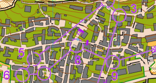
And this is indeed an interesting leg – such a long route choice leg at the first leg of a relay can be very challenging – especially for youths who don’t have too much experience. The leg is as usually first provided without routes – you may take a look at it and think about how you would attack this leg (if the image is too small, you may click on it to get it larger):
![]()
Location
You find other maps from the area in omaps.worldofo.com here. See also latest additions in 3DRerun from this area in order to learn more about this terrain type.
Webroute
Next you can draw your own route using the ‘Webroute’ below. Think through how you would attack this leg, and draw the route you would have made. Some comments about why you would choose a certain route are always nice for the other readers.
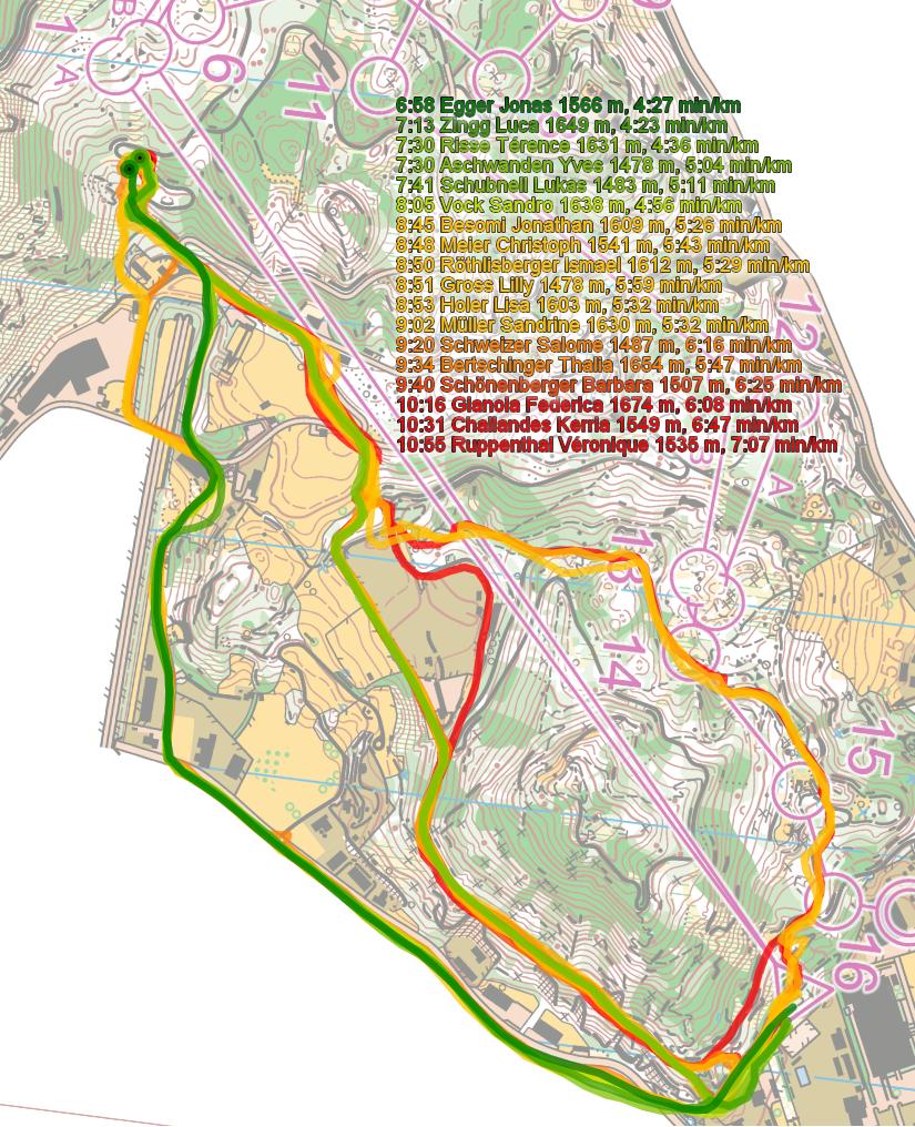
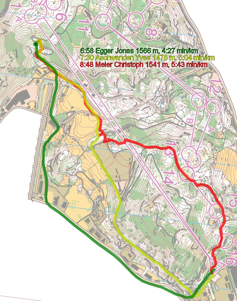
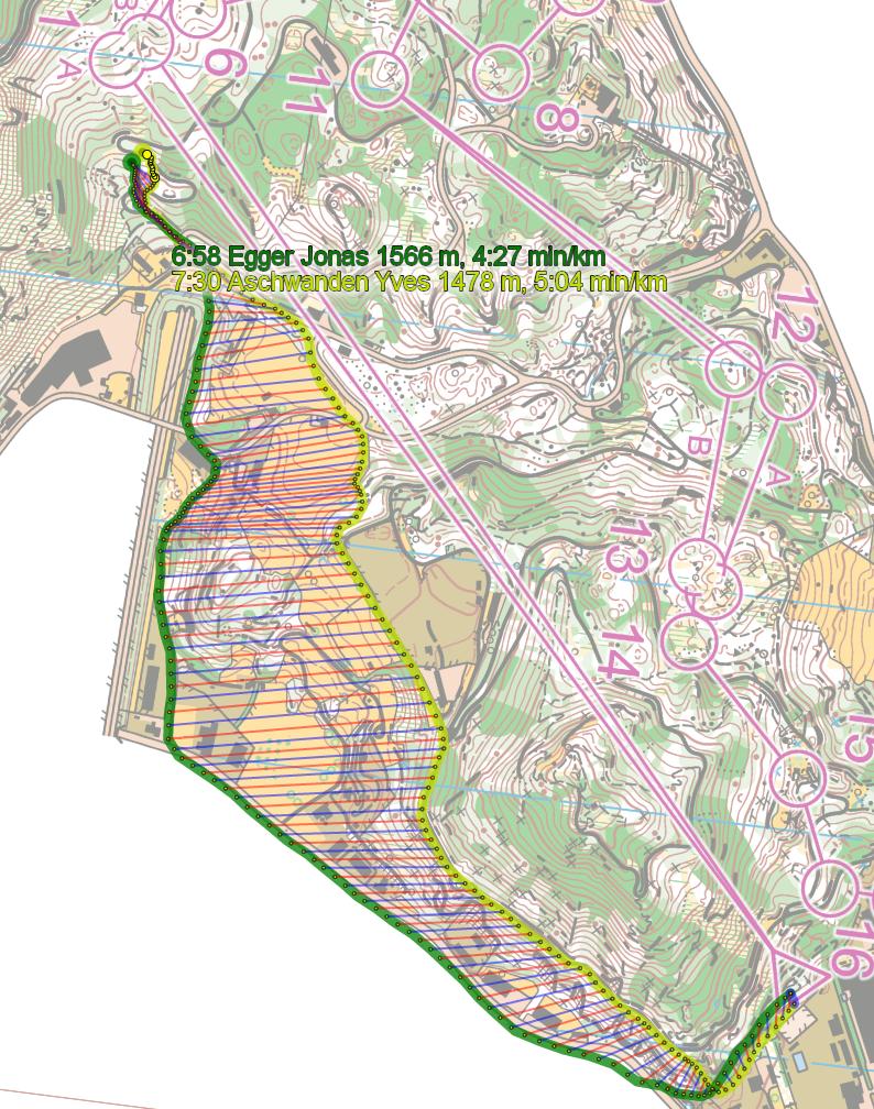
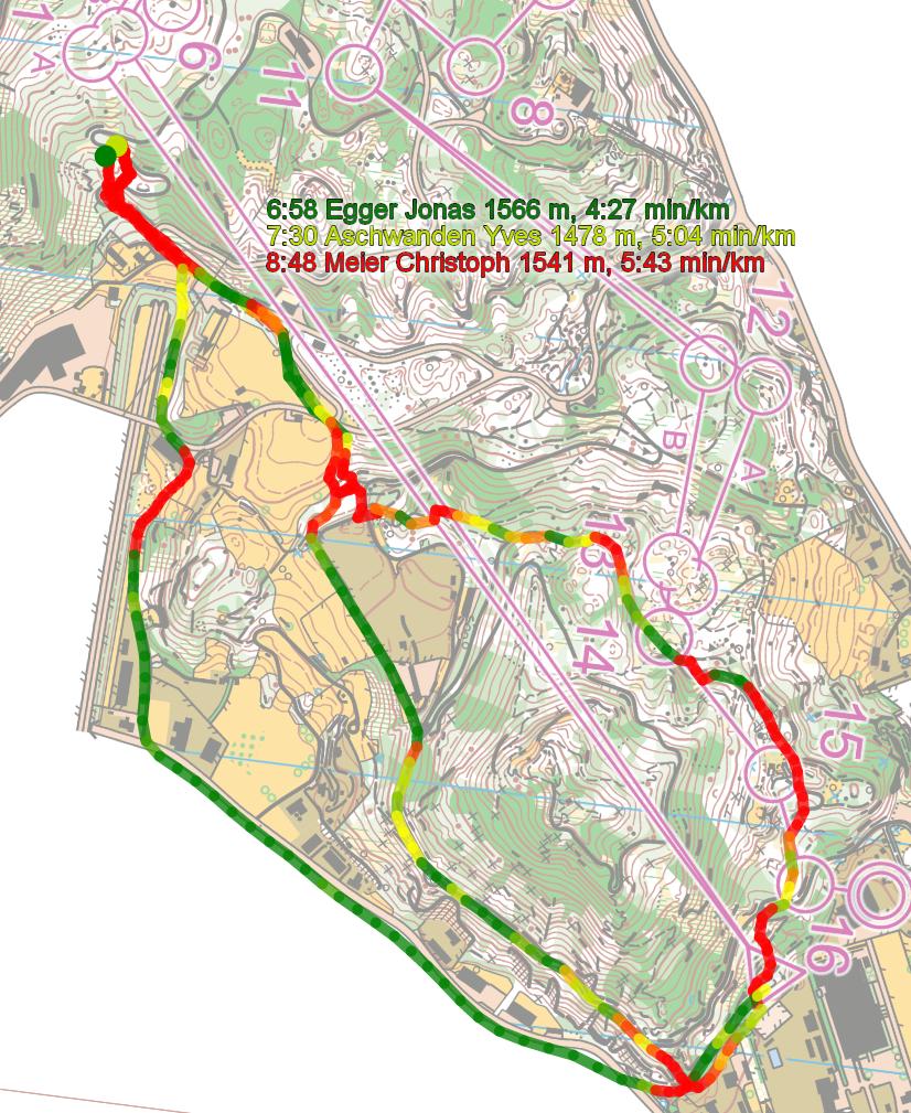
Then you can take a look at how the runners have solved this leg below. I have included several illustrations (note however that there is something strange with the GPS-data, so don’t trust the names given – the times should be OK though) – but you get the idea already from the first one: Going around to the left seems to be faster – at least based on the runners for which we have GPS-data. The reason is that even it is longer, you save some height and the running is faster on the road. The last of the illustrations compares the speed the runners have held on the leg with a color scale going from green at below 3:40 min/km to read at above 5:00 min/km.

Density map
See below for a density map of some of the ones who have drawn their routes so far.

Additional information
You find the complete map in omaps.worldofo.com at this location.
Route to Christmas series
The ‘Route to Christmas’ series at World of O has been very popular the last years – and I have therefore decided to continue the series this Christmas as well. If you have got any good legs in RouteGadget, GPSSeuranta or 3DRerun from 2013-competitions – or old forgotten ones which are still interesting – please email me the link at Jan@Kocbach.net, and I’ll include it in Route to Christmas if it looks good. Route to Christmas will not be interesting if YOU don’t contribute.
Not all legs are taken for the interesting routechoice alternatives – some are also taken because the map is interesting – or because it is not straightforward to see what to do on a certain leg. Any comments are welcome – especially if you ran the event chosen for todays leg!
Note that there may be some errors in the Routegadget data (sometimes somebody draws a route for another runner just for fun). Please add a comment below if you spot en error.


Love this route to christmas – thanks Jan
I notice on this leg the fastest times are all boys and the slower times are all girls – so you need to take that into account in the comparisons.
Would it be possible in the data for each leg to also include each runners’ time and placing for the whole course? That way we can make a judgment (not perfect but it gives some idea) about the relative speed/ability of the runners.
Thanks for your comment, Rob! And yes, I took into account that the slower are all girls – in the second illustration I look at only the men. The way I usually look at these analysis is to,
1) Make the overall comparison of all runners with colors for their speed (the first illustration). It gives you a clear indication about which route was run fastest directly through the colors. The routes are drawn with the fastest on top, so you will see the color of the fastest route on each routechoice clearly.
2) Then I take the fastest runner on each route (the second illustration), and compare the times of those. For these, I then usually take a look at the overall times for the runners to see their relative speed (or rather, I look at their speed in parts of the course where they run the same route, which is more accurate as you get rid of mistakes then).
For this particular race I had issues with the GPS-data as I wrote in the text – each GPS-unit being used twice around the course (actually it is a problem with my import from GPSSeuranta – I had a workaround once, but it had some other issues, and I have not had time to look into it again) – so it was tricky to get full overview of the data, unfortunately. To include the overall times of each runner in the first type of illustration is unfortunately too much work to be feasible, and I think it is not really necessary either. The thought here is to get an overview of the leg.
That said, I agree that it would be good to extend the detailed analysis also to the girls – i.e. look at the fastest girl at each route, but I was kind of put off by the problem with the GPS-data. Thanks a lot for your comment!
Anyway: I still think the data point quite clearly towards left being faster – but not as much as it may look like here (there is a quite fast time going all the way to the right as well).
I agree the left looks better.
I certainly didn’t mean adding the overall times if it meant a lot of work – just if it was easy to do. If I am really that interested I can of course look up the results and splits myself.
One question concerning the mapping style:
On the map we can see several roads with a high fence on one side. Road and fence are mapped without space between the symbols. Is this a common way to map this situation?
For me as less experienced orienteer this was quite confusing as I know these larger uncrossable fences from sprint maps. I didn’t associate this symbol with a road with an adjacent fence.
There should be a minimal gap of 0.15mm http://www.swiss-orienteering.ch/files/kommission_karten/kt/kt2013_anleitung_ol-karten-herstellung.pdf#page19
Look at page 19.
Danke!
Thanks Jan! Really cool!
Is it possible to display the routes in different colors? I have a red-green debility of sight.