 World of O News
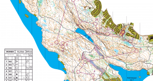
Today we are traveling out of Europe – to the USA! The leg in Route to Christmas is leg 11 in the M21 course from the US Champs long distance organized at May 12th 2013.
The leg is not chosen based on a tip – but because the terrain looks very interesting. I was very unsure which leg to choose – so I took two (scroll down for the bonus leg). If somebody has more information about the race and/or the terrain – please add a comment below!
The leg is as usually first provided without routes – you may take a look at it and think about how you would attack this leg (if the image is too small, you may click on it to get it larger):
![]()
Location
You find other maps from the area in omaps.worldofo.com here. See also latest additions in 3DRerun from this area in order to learn more about this terrain type.
Webroute
Next you can draw your own route using the ‘Webroute’ below. Think through how you would attack this leg, and draw the route you would have made. Some comments about why you would choose a certain route are always nice for the other readers.
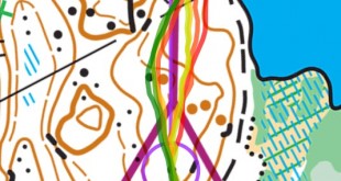
Then you can take a look at how the runners have solved this leg below.
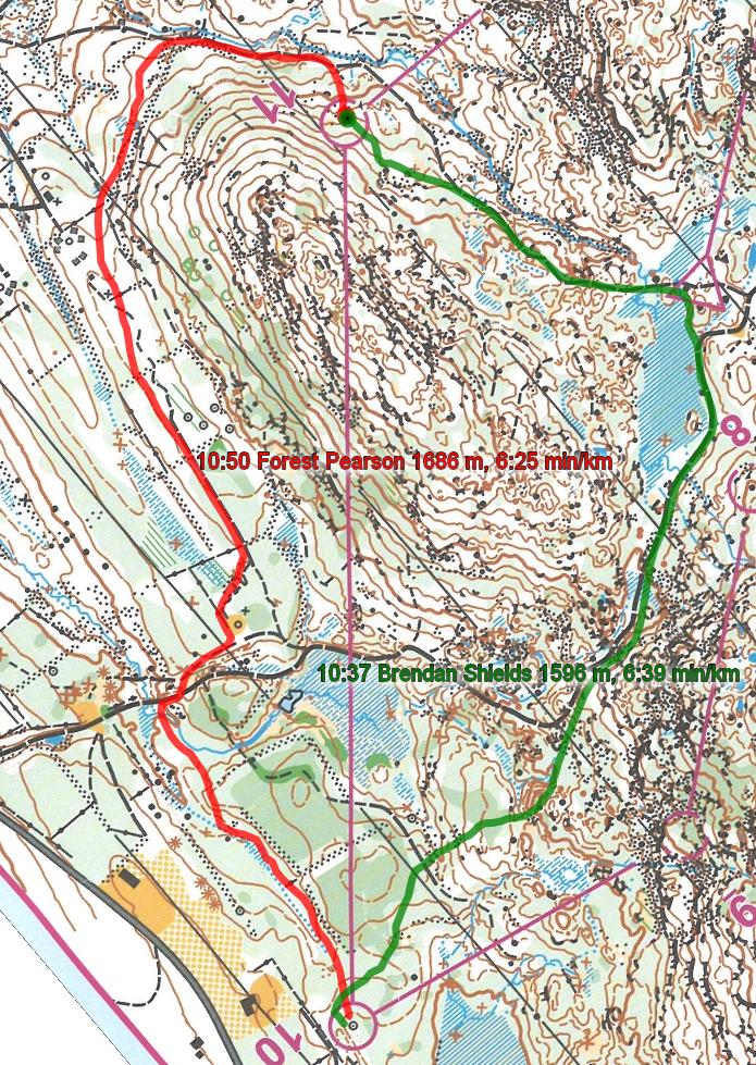
As there are only two GPS-routes available, it is difficult to say anything very clearly about which route is the fastest. My tip goes to the leftmost variant though – as it is only slightly longer but offerst better runnability overall. Looking at the pace comparison, it looks like Shields going right has higher running speed – and that this is the reason for his faster split time. However, I am sure our US readers know more about this – and am looking forward to a comment!
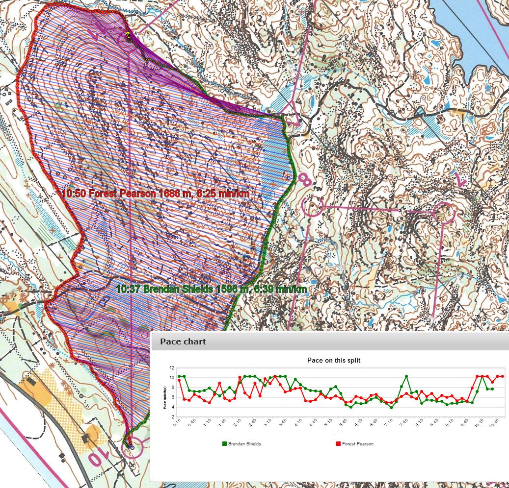
Density map
See below for a density map of some of the ones who have drawn their routes so far.

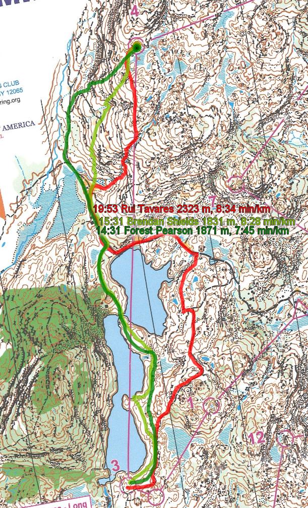
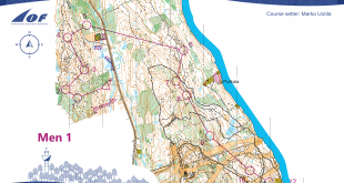
Bonus leg: Leg 4
The leg is as usually first provided without routes – you may take a look at it and think about how you would attack this leg (if the image is too small, you may click on it to get it larger):
![]()
Location
You find other maps from the area in omaps.worldofo.com here. See also latest additions in 3DRerun from this area in order to learn more about this terrain type.
Webroute
Next you can draw your own route using the ‘Webroute’ below. Think through how you would attack this leg, and draw the route you would have made. Some comments about why you would choose a certain route are always nice for the other readers.
Then you can take a look at how the runners have solved this leg below.
Additional information
You find the complete map in omaps.worldofo.com at this location.
Route to Christmas series
The ‘Route to Christmas’ series at World of O has been very popular the last years – and I have therefore decided to continue the series this Christmas as well. If you have got any good legs in RouteGadget, GPSSeuranta or 3DRerun from 2013-competitions – or old forgotten ones which are still interesting – please email me the link at Jan@Kocbach.net, and I’ll include it in Route to Christmas if it looks good. Route to Christmas will not be interesting if YOU don’t contribute.
Not all legs are taken for the interesting routechoice alternatives – some are also taken because the map is interesting – or because it is not straightforward to see what to do on a certain leg. Any comments are welcome – especially if you ran the event chosen for todays leg!
Note that there may be some errors in the Routegadget data (sometimes somebody draws a route for another runner just for fun). Please add a comment below if you spot en error.
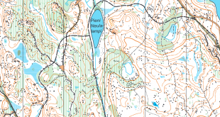
Since noone has made a comment on the terrain yet, I’ll do it now.
The map look very similar to the ones from the 1993 World Champs north of New York City, but greener. Terrain is a little similar to Sörlandsterreng in southern Norway. Leaf-trees (maple and red oak) stony ground. You need quite some feeling for the good trail / trace through the forest to run really fast there. Running around in a good trace ist also quite fast.
see here:
http://www.orientering.dk/julekalender06/woc1993e.jpg
Thanks for the comment, Rolf. That was also my impression when seeing the map – although I guess the ground is a bit different than in Grimstad?