 World of O News
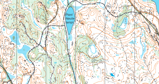
Today we have got some really exotic terrain in Route to Christmas. This Croatian terrain on the island of Krk looks very special because of all the stone walls. The varying runnability in addition to all these stone walls also makes the route choice challenges quite interesting. Should you go for the ski-orienteering/MTB-O thinking here and only use the big paths – or use the Bergman/Lundanes “the shortest route is always straight” routine?
Thanks a lot to Matjaz Stanfel for collecting the routes from the runners and preparing the map and splits material. Thanks also for the runners for sending their routes to Matjaz.
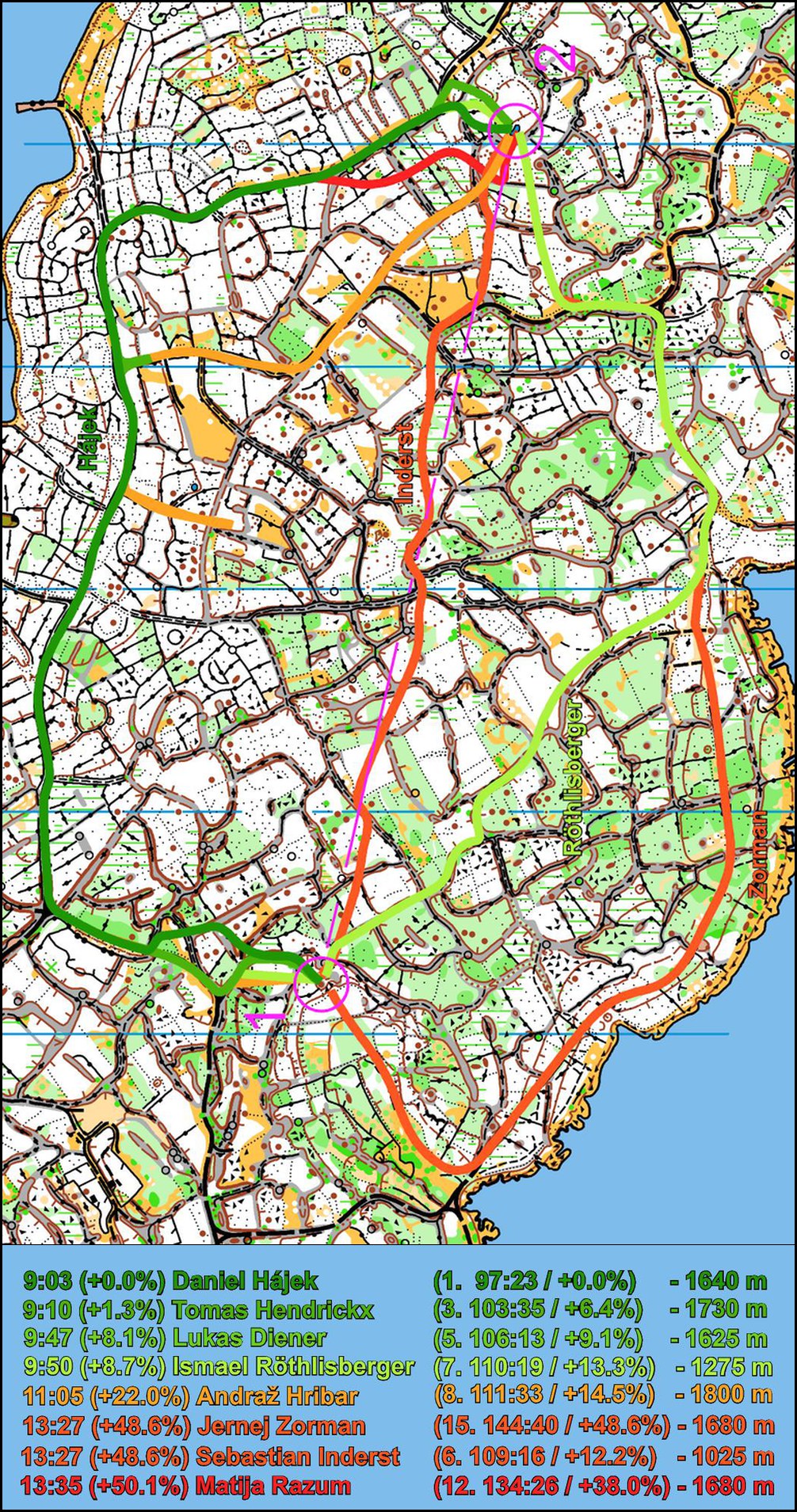
The leg is as usually first provided without routes – you may take a look at it and think about how you would attack this leg (if the image is too small, you may click on it to get it larger). Note that the contour interval is 5 meter and scale used on event were 1:15:000 so runners needed to be quite focused on map reading. To explain terrain runnability is a rather difficult task. Runnability in white area is medium good while running in green area is quite difficult. Running on stone walls/hills may be faster than running in dense forest, but running on paths on top of the walls is slower than running on wide vehicle tracks or on clear white areas. And remember: Your task here is to find the fastest route, not the most fun route (which would definitely be the direct one).
![]()
Location
You find other maps from the area in omaps.worldofo.com here. See also latest additions in 3DRerun from this area in order to learn more about this terrain type.
Webroute
Next you can draw your own route using the ‘Webroute’ below. Think through how you would attack this leg, and draw the route you would have made. Some comments about why you would choose a certain route are always nice for the other readers.
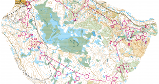
Then you can take a look at how the runners have solved this leg below. Here is Matjaz’s analysis:
At first sight, the analysis looks very clear: Going north on wide path is fastest while you loose time by going straight or south. However, none of runners who drew their routes took the optimal route! It is Andraž Hribar (orange color – note the mistake halfway) who was the closest to the solution, but he made an extra 300 meters due to mistake halfway on the route. It was also Ismael Röthlisberger (light green) who gained a lot on this leg comparing to percentage of time behind Hajek on this leg by running south, so it would be interesting to see GPS analysis from this leg. Unfortunately, due to World Ranking Event no GPS watches were allowed.
[Editors comment: With the most interesting races in the “smaller” countries often being WRE-races, it is quite unfortunate that these are exactly the races where the runners can’t do any real analysis after the race as GPS-watches is not allowed – and thus not learn to get better. I still think this rule is not necessary for this level of events…]
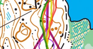
Density map
See below for a density map of some of the ones who have drawn their routes so far.

Additional information
You find the complete map in omaps.worldofo.com at this location.
Route to Christmas series
The Route to Christmas series at World of O has been very popular the last years – and I have therefore decided to continue the series this Christmas as well. If you have got any good legs in RouteGadget, GPSSeuranta or 3DRerun from 2014-competitions – or old forgotten ones which are still interesting – please email me the link at Jan@Kocbach.net, and I’ll include it in Route to Christmas if it looks good. Route to Christmas will not be interesting if YOU don’t contribute.
Not all legs are taken for the interesting routechoice alternatives – some are also taken because the map is interesting – or because it is not straightforward to see what to do on a certain leg. Any comments are welcome – especially if you ran the event chosen for todays leg!
Note that there may be some errors in the Routegadget data (sometimes somebody draws a route for another runner just for fun). Please add a comment below if you spot en error.
I definitely agree with your analysis about GPS interdiction in WRE, it’s nonesense and that’s a pity for the analysis and developpment of orienteering.