World of O News
A leg in the gold mining area of the Australian Championships Long 2015 is the most suggested leg for Route to Christmas this year – this should be perfect entertainment for a Sunday in December.
Most of the deep erosion features were made by high pressure water jets which washed loose gravel that was then processed to extract the gold
The chosen leg is the 5th leg in both the M21E, the W21E and the M17-20E course from Australian Championships at October 3rd 2015. The intricate gold mining terrain as well as the “uncertain vegetation” made route choice difficult. This race has been suggested by Rob Plowright, Ralph Street, Riley De Jong, Lizzie Ingham, Theo Fleurent and Tommy Hayes – thanks! Thanks also to everybody suggesting legs for Route to Christmas 2015 – more than 60 e-mails received & 40-50 legs suggested. Definitely a new record!
Two different legs have been suggested – leg 4-5 and leg 12-13. Most people suggested leg 4-5, and that one is therefore featured first. However 12-13 looks in many respects just as interesting, and that leg is therefore included as a bonus below leg 4-5. Maybe you can even learn from leg 4-5 (as the runners could) and apply this to leg 12-13?
Leg 4-5
Rob Plowright has written a great introduction to the area and the terrain:
This map is near Ballarat, 100km west of Melbourne. Ballarat was where the 1850’s gold rush started and many of the forests around there still show the signs of mining which is what makes this terrain interesting. Most of the deep erosion features were made by high pressure water jets which washed loose gravel that was then processed to extract the gold. These earth cliffs can be up to 5m high in places. There are a lot of gold mining areas in this part of the country – the 1985 WOC relay was held in gold mining terrain a bit further to the north and in 1994 a World Cup middle distance was held in very similar terrain just to the south of this map.
This map sits on the Great Dividing Range (‘great’ refers more to the length of the range rather than the height) and has relatively high rainfall which makes the ground a little softer than the usual rock hard terrain that Australia is famous for. And the vegetation is a little lusher than usual – the green stripe is usually bracken. These factors tend to mean slightly wider route choices can come into play,
Probably the most important thing in this terrain is to try to avoid the erosion gullies as much as possible. It is surprising just how much time you can lose scrambling up and down the earth cliffs [..] You should never just assume ‘straight is best’ (Rob Plowright)
Probably the most important thing in this terrain is to try to avoid the erosion gullies as much as possible. It is surprising just how much time you can lose scrambling up and down the earth cliffs. On top of the fact that they are steep and slippery it actually adds a lot of extra climb. Even on the shorter legs it is important to keep this in mind and it is often better to make small detours to get out of the erosion – you should never just assume ‘straight is best’. Also it is a lot easier to navigate if you are up the top of the erosion where you get a better view of the terrain – in the bottom of the gullies all you can see is two earth walls – and one earth wall looks pretty much like another..
Tommy Hayes adds: – The forest was runnable, but thick in places, particularly in the gullies. It was also very hot this day.
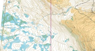
The leg is as usually first provided without routes – you may take a look at it and think about how you would attack this leg (if the image is too small, you may click on it to get it larger):
![]()
Location
You find other maps from the area in omaps.worldofo.com here. See also latest additions in 3DRerun from this area in order to learn more about this terrain type.
Webroute
Next you can draw your own route using the ‘Webroute’ below. Think through how you would attack this leg, and draw the route you would have made. Some comments about why you would choose a certain route are always nice for the other readers.
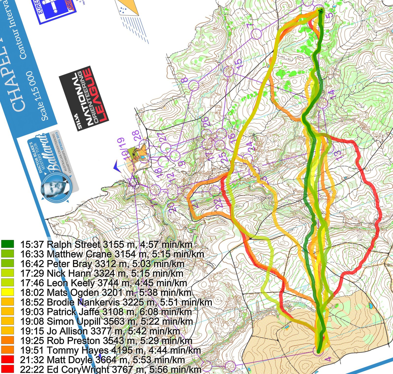
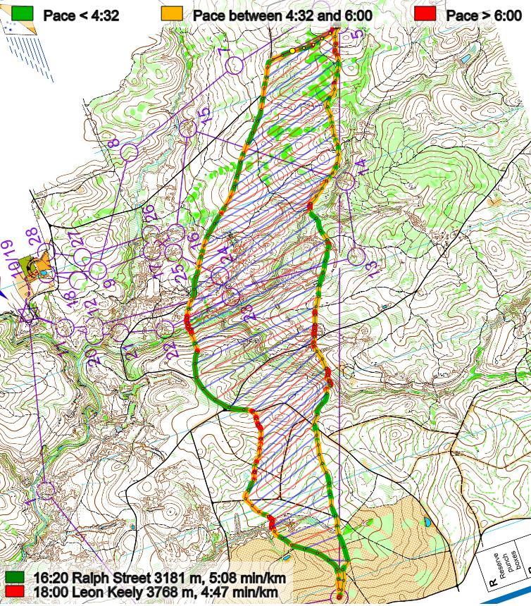
Then you can take a look at how the runners have solved this leg below. First an illustration which shows the fastest regardless of category. Note Jo Allison (W21E) in there at 19:15.
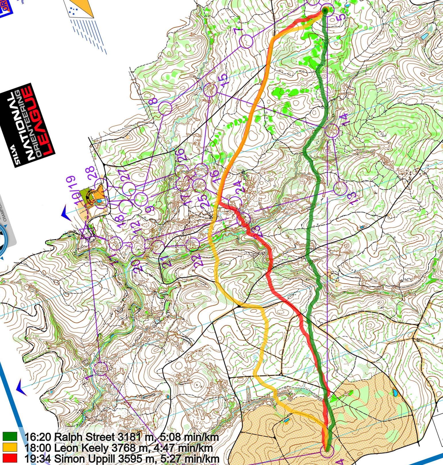
Then a comparison of three distinct routes among the men:
And finally a comparison of the women:
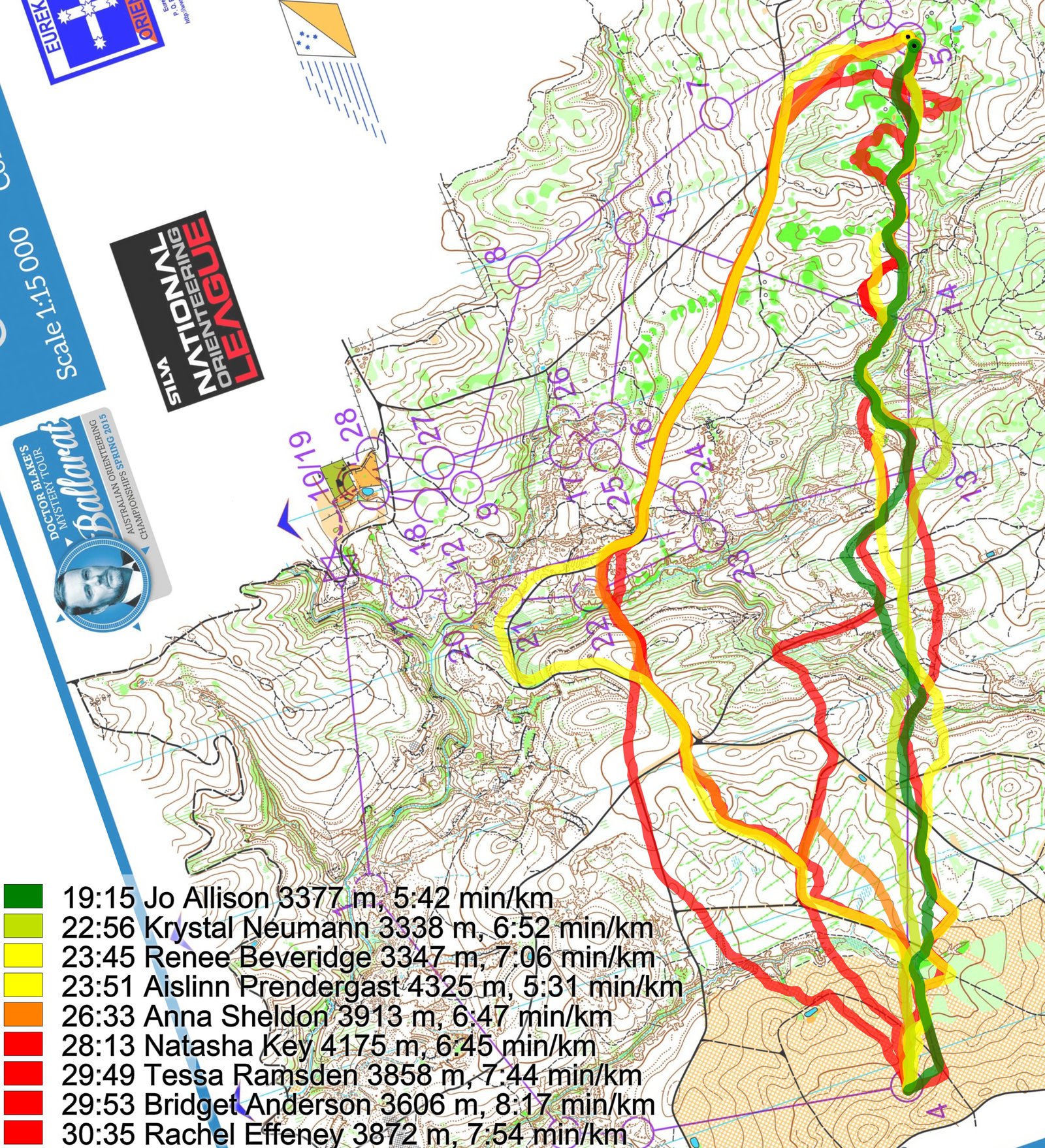
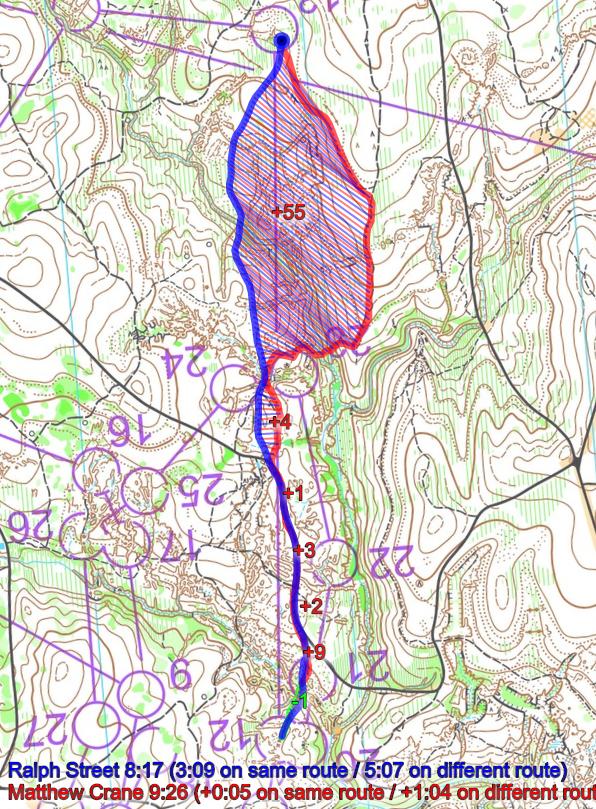
Even though these are runners on different levels, the conclusion is quite clear already from the illustrations. Going quite straight is fastest, but you can also loose time direct. Here is Ralph Street’s analysis (fastest on the leg):
I had made some mistakes on the first three controls so I did not look in detail at this leg until I had reached the fourth control. When a leg is this long it is always tempting to look for wider routes, however with the speed of the forest you cannot run too far from the line otherwise you are losing time. The road on the left was tempting, however, I could not see a good way to get to the start of it, and it was quite far from the straight line. Right of the line offered too much climb and no helpful features. This left straight as the only viable option, using the track for the final section and then trying to avoid too much climb or greener areas on the way there. I felt that I lost a bit of time in the middle section of the leg, but otherwise I was pleased with how I executed this leg.
Below is a look at the pace of the Street (straight) and Keely (left). As you can see there are quite a few slow places on the left routechoice – some of them even slower than straight – and therefore it is not worth the extra length.
Density map
See below for a density map of some of the ones who have drawn their routes so far.

Bonus: Leg 12-13
This time there is a lot more of the erosion gullies straight. The leg is as usually first provided without routes – you may take a look at it and think about how you would attack this leg (if the image is too small, you may click on it to get it larger):
![]()
Next you can draw your own route using the ‘Webroute’ below. Think through how you would attack this leg, and draw the route you would have made. Some comments about why you would choose a certain route are always nice for the other readers.
Then you can take a look at how the runners have solved this leg below.
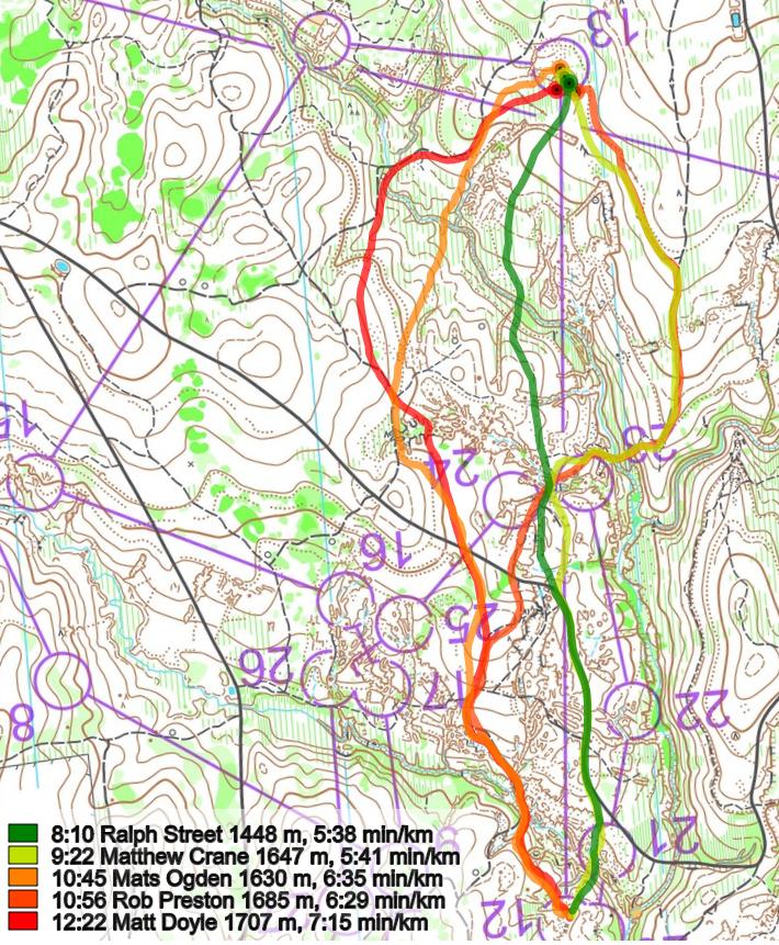
Lizzie Ingham’s analysis:
Here the route choice starts right from the control, with a lot of mining detail immediately ahead which you have to cross somehow. Down in the mining gullies can be very slow, and it’s tempting to read more detail than you need to. But then you need to toss up how far off the line it’s worth going to avoid it.
And then again the analysis of Ralph Street:
The same rules about trying to run as straight as possible applied to this leg as well, although I almost did choose the track option to the right. In the end I decided that I would be able to get through the green stream on the straight choice quickly (because I had done it before) and I was feeling strong in the terrain so I felt this was a good option. I ended up missing the control in the circle, which was a theme for my race. However, I don’t think that going out to the right would have been a significantly safer approach to the control.
Density map
See below for a density map of some of the ones who have drawn their routes so far.

Additional information
You find the complete map in omaps.worldofo.com at this location.
Route to Christmas series
The Route to Christmas series at World of O has been very popular the last years – giving the readers the opportunity to do one Route Choice Challenge each day from December 1st until December 24th. If you have got any good legs in RouteGadget, GPSSeuranta or 3DRerun from 2015-competitions – or old forgotten ones which are still interesting – please email me the link at Jan@Kocbach.net, and I’ll include it in Route to Christmas if it looks good. Route to Christmas will not be interesting if YOU don’t contribute.
Not all legs are taken for the interesting routechoice alternatives – some are also taken because the map is interesting – or because it is not straightforward to see what to do on a certain leg. Any comments are welcome – especially if you ran the event chosen for todays leg!