 World of O News
Today’s leg in Route to O-Season 2020 is from Switzerland in October 2017 – from the 9th National race at Mount Rigi. The chosen leg is the 11th leg in the M21E course. Thanks a lot to Sven Aschwanden for the leg and a long analysis text!
Sven writes the following about the course and terrain:
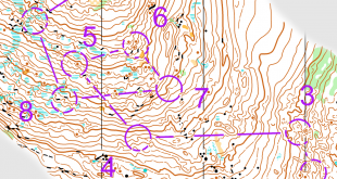
The course was a shortened long distance with a winning time of 65 minutes. Course setter Kornel Ulrich, himself a former elite-runner, set a course with several bigger route choices alternating with shorter legs in more detailed terrain. After approx. 20 min of race time the runners arrived at this route choice. The terrain at the well-known Mount Rigi in central Switzerland is typical pre-alpine terrain, which means that there is in general good runnability.
What’s to say about the terrain at Mount Rigi is, that it might look quite stony in some parts but actually apart of the big stones shown on the map there are no stones on the ground which would slow down the running speed. However, for the choice of your route you have to take into account that the grassland/meadows (the yellow on the map) is heavily “marked” by cows, so there are many cow tracks following the height, but they are quite bumpy and the grassland is somewhat rougher to run through at it might look at the first sight.
The leg is as usually first provided without routes – you may take a look at it and think about how you would attack this leg (if the image is too small, you may click on it to get it larger):
![]()
Location
You find other maps from the area in omaps.worldofo.com here. See also latest additions in 3DRerun from this area in order to learn more about this terrain type.
Webroute
Next you can draw your own route using the ‘Webroute’ below. Think through how you would attack this leg, and draw the route you would have made. Some comments about why you would choose a certain route are always nice for the other readers.
Then you can take a look at 4 alternatives A-D for Sven’s analysis here. Routes:
- A: 1679 m, 215 m HD+, 12:07 min, Pascal Buchs (+ 0.0% leg /+ 6.8% overall)
- B: 1945 m, 205 m HD+, 12:19 min, Ueli Werren (+ 1.6% leg / + 0.0% overall)
- C: 1934 m, 195 m HD+, 12:24 min, Simon Hodler (+ 2.3% leg / + 6.4% overall)
- D: 1594 m, 155 m HD+, alternative
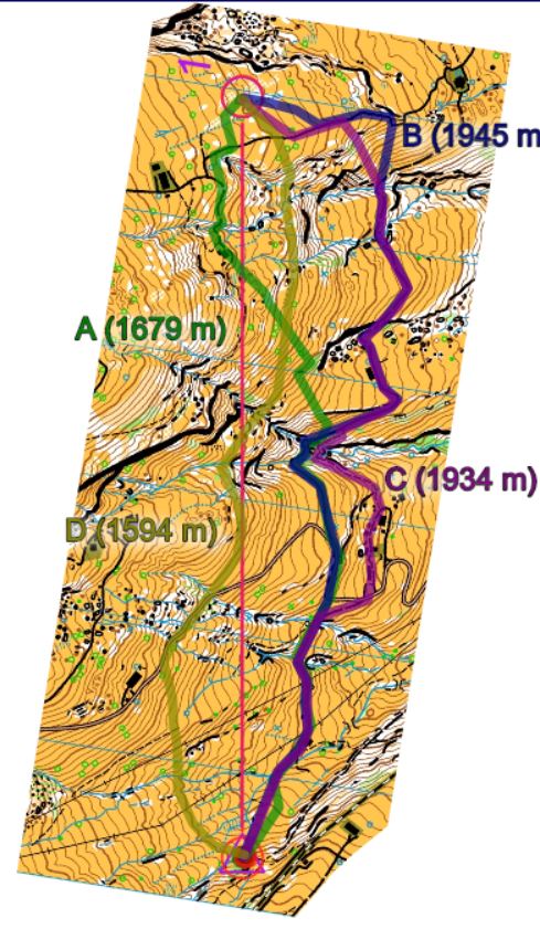
Analysis by Sven: The analysis is based on GPS-tracks, self-drawn routes of the runners on Routegadget and the experiences made running the same leg some weeks after the official competition. Please note that not all of the top-ranked runners on this leg uploaded their GPS-track/drawn their route on Routegadget. Fastest on this leg was Joey Hadorn with a time of 11:35 min, but as his route is not available, he was not taken into account in the analysis.
Fastest was A, run by Pascal Buchs. A is about 270 m shorter than the B and C alternative and has, as B and C, the advantage of running a lot on paths. However, a significant part of the climb (150 m out of 215 m HD+) has to be done in the same slope. Buchs is a very skilled trail and sky runner so this choice might be fast for him but maybe less for a more average runner.
Not much slower than A were the B and C options, run by Ueli Werren and Simon Hodler. Both options are quite a lot longer than A but they include a bit less of climb and especially the climb is better to handle as the longest and steepest climb counts “just” about 100 m HD+. Almost whole of the route can be made on paths.
In my opinion worth a look is the D option which was run by no one of them who shared their route. D is the shortest option and has significantly less climb than all the other options. In addition, the climb is split up and has not to be made at once. However, almost no path-running on this route. Taking into account the partly bumpy underground, this lowers the speed, as the several small ditches which have to be crossed do as well. In addition, running of the paths means constant map contact, which lowers the speed too. But in a open terrain like this, map contact can be reduced a lot by lifting the head and making use of the good visibility.
There are some negative points about the D option but regarding that it is much shorter, has less climb than the others and that the passages between the cliffs were very well runnable, I would guess that this can be the fastest alternative.
You can look at the whole course and also the W21E course following this link: http://www.routegadget.ch/binperl/reitti.cgi?act=map&id=241
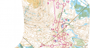
Density map
See below for a density map of some of the ones who have drawn their routes so far (available during the day when some readers have drawn their route).
![]()
Additional information
You find the complete map in omaps.worldofo.com at this location.
Route to O-Season 2020 series
Route Choice Challenges while waiting for the real action: With the upcoming orienteering season indefinitely on hold in large parts of the the world due to COVID-19, regular orienteering route choice challenges may be one way to make sure those orienteering skills don’t get completely rusty. I’ll try to keep these coming daily, but need help from all of you out there to keep them coming and to keep up a certain quality.
Tips on good route choice challenges – either from races/trainings (even cancelled ones) or theoretical ones with accompanying analysis – are very welcome (please e-mail to jan@kocbach.net).
Not all legs are taken for the interesting routechoice alternatives – some are also taken because the map is interesting – or because it is not straightforward to see what to do on a certain leg. Any comments are welcome – especially if you ran the event chosen for todays leg!
Hello Jan
First, thanks a lot for implementing this adaption of the “Route to christmas” aka. “Route to O-season 2020″ series.
I was also running this competition, not in Elite’s class but in Junior’s Class (H20) and we had the same routechoice (Look also the routes for H20 on routegadget.ch). As an addition to the upper analysis of this leg, it’s worth to say that at this day, it was quite shitty wheather on mount Rigi including fog, rain and snow. That means that the visability at this day was quite bad and the slopes quite slippery or let’s say deep for running. At a sunny day, it would have been a really good alternative to choose the straight route in the middle, but at this day, i would be unsure…
That’s probably a second main reason, why so many of the runners took a route on the paths on the east.
Greetings, Julian
I’ll echo Julian’s thanks to Jan, it is really nice to have these desktop technical exercises in a difficult time!
Julian, thanks for coming in with this information about special weather conditions! I immediately thought of and entered that direct/flat contouring route and was surprised that it hadn’t been used by the competitors, particularly since I have seen lots of tracking from similar events in Switzerland, and there you guys always seem quite willing to run direct routes across yellow fields, away from the paths.
Regards,
Terje
i was running this leg in H45. In our class the fastest times were run on Route B, 3 Minutes slower than the Elite Runners. There was another interesting long leg (19-20 in HE/12-13 in H45) with very different route choices:
H45: https://www.routegadget.ch/binperl/reitti.cgi?act=map&id=242&cID=8&kieli=
HE: https://www.routegadget.ch/binperl/reitti.cgi?act=map&id=241&cID=1&kieli=