 World of O News
In today’s leg in Route to O-Season 2020 we move one year forward to WOC Long in Denmark – another classic with a nice, long leg.
This was the big day of Finland’s Jani Lakanen, and this leg was were he started gained time on his closest rivals. This is the text from the WOC around the clock magazine describing the popular Finn’s race:
Lakanen was among the leaders right from the beginning of the course, but it was on the longest leg of the course, towards the 16th control where he gained two minutes on his nearest rivals. There were several possible route choices and Lakanen took the […]. When he came to the first TV control, he had a solid lead and from there on he followed the winning track all the way into the finish. This victory surely is the most precious trophy in the collection of this nice Finn.
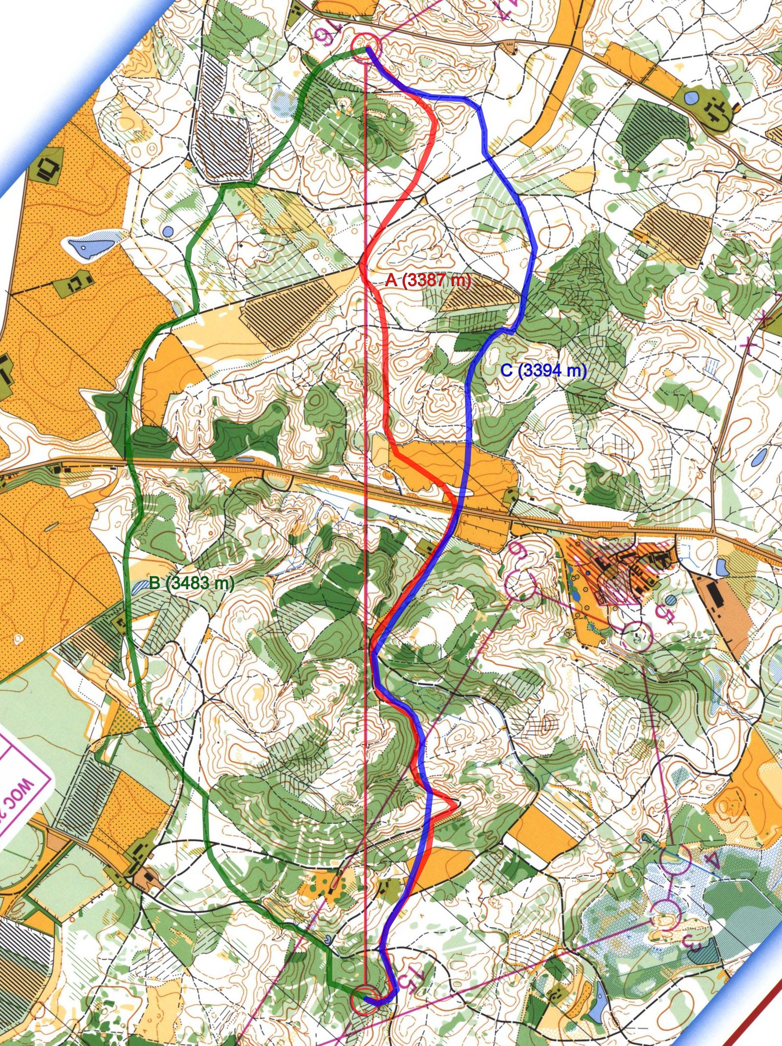
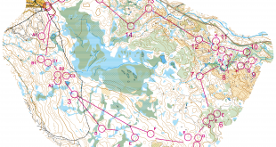
The “secret sauce” of the long leg is omitted in this text, but can you see from the map how this leg should best be solved in a tough long distance race? The leg is as usually first provided without routes – you may take a look at it and think about how you would attack this leg (if the image is too small, you may click on it to get it larger):
![]()
Location
You find other maps from the area in omaps.worldofo.com here. See also latest additions in 3DRerun from this area in order to learn more about this terrain type.
Webroute
Next you can draw your own route using the ‘Webroute’ below. Think through how you would attack this leg, and draw the route you would have made. Some comments about why you would choose a certain route are always nice for the other readers.
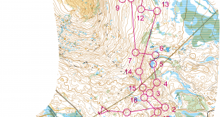
Then you can take a look at some possible routechoices below. Lakanen’s route is the green one to the left (Lakanen won the leg in 15:27; Gonon was second fastest in 15:35 running the same route). Andrey Khramov (second overall) run the third fastest time on the leg with the blue variant to the right (15:37), thus it was possible to run fast also along the other routes. Marc Lauenstein (third overall) ran mostly like the red variant in 15:54 (but with a different last part into the control).
The two minute advantage in the “WOC around the clock” article is not directly evident from the split times as the closest competitors overall lost less than half a minute on this leg, but Lauenstein and Khramov were down in 7th and 8th before the long leg, while runners placed in the top at this time lost more time: Leader Valentin Novikov lost 1:23 (no route available online), third placed Michal Smola lost 1:06 (red route) and fourth place Anders Nordberg lost 2:28 on unknown route (no route available online).
The GPS-tracking from WOC 2006 does not seem to work anymore, but if you are interested to dig further into this leg you can check out routes drawn by the runners by hand here, split times here, and the WOC around the clock magazine for the day after the Long competition here. Big kudos to the Danish WOC organizers for still paying for having the webpage up – a lot to learn for other WOC organizers here (the Czech organizers from 2008 are in the same league, BTW) – let’s hope the Danes get the chance to show that they can deliver again at WOC 2020!
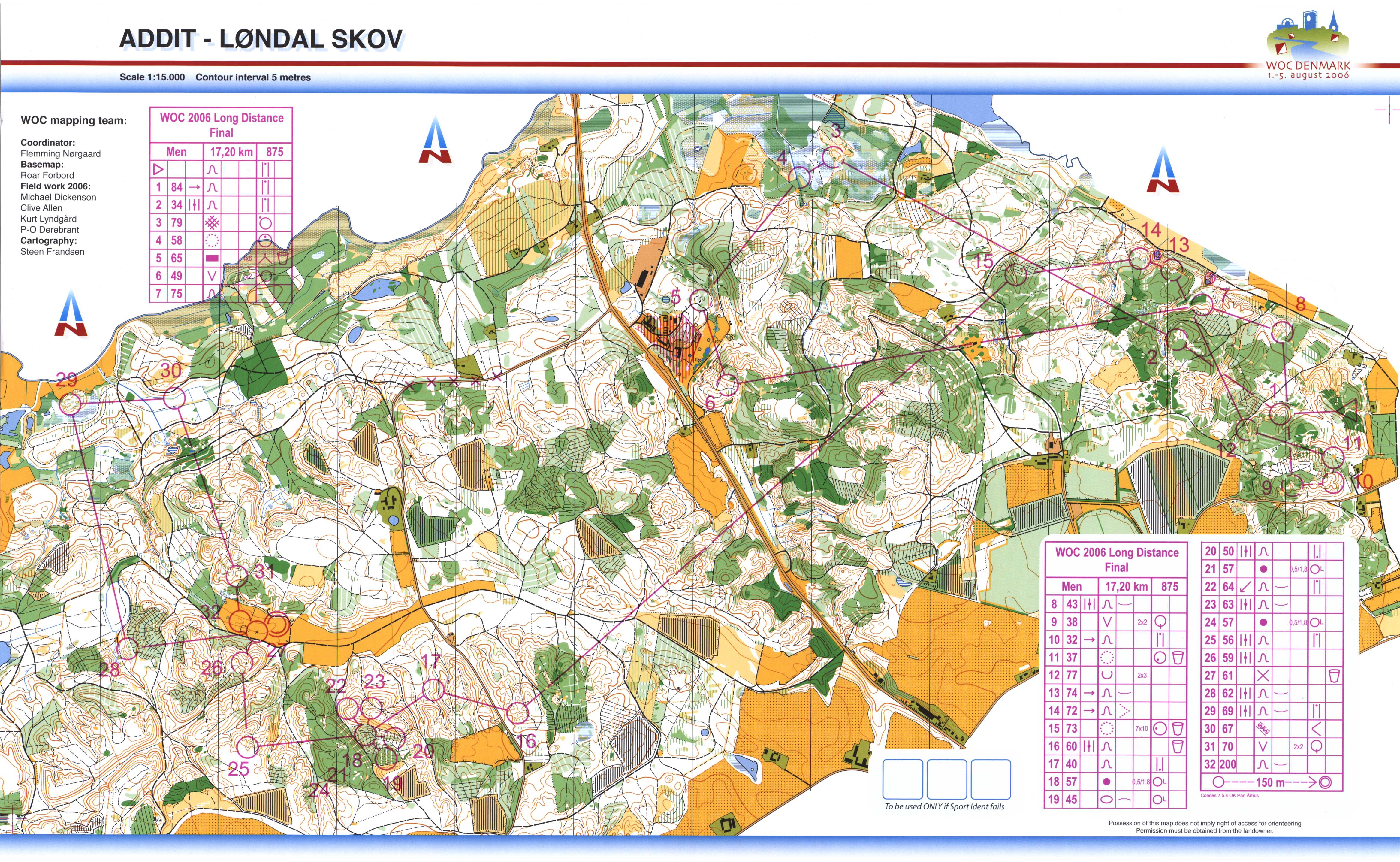
And here is the complete map in good quality:
…
Update from Björn Persson: Story behind the long leg
Following orienteering at a distance these days, I was very excited to see the “long leg” from WOC 2006 making its way to the series “Route to…”.
There is a very intriguing story behind this particular leg, that very few know about. Now, fourteen years after the event, and in light of its reappearance in the orienteering daylight, I felt it could deserve to be told!
I was assigned as IOF Senior Event Advisor for WOC 2006, working closely with Flemming Norgaard, Erik Nielsen and the central leadership. For the long distance, we had a unique chance to use the Addit-Löndal forest, a big private estate never used before for orienteering. The permission was one-time only, it was clarified that it would never be opened for orienteering again. Its quality and unique nature motivated the organizers to invest in mapping it, a big cost to create an extra edge to WOC 2006.
When Flemming Jörgensen and the course planning team came up with the first course drafts in winter 2005, they had created a very intriguing design with many interesting challenges. However, we felt something was missing and asked Flemming to come back with a revised design involving what we called a “signature leg”, something that would make the orienteers remember this day and this course for a long time! Together, we had seen the possibility of a longer stretch east-west. Could there be a solution? Flemming came back a couple of months later with a revised design, now including the leg which turned out to be so decisive for the outcome of WOC 2006 Long.
But the drama had only just begun! The leg demanded crossing a road which cuts the Addit-Löndal forest in two equally sized parts. And not just “a” road but the main road between Horsens and Silkeborg. With the new design, it was evident that this road had to be closed for traffic. A big inter-city road, completely closed. In my role I had to set this as a condition for approving the course design, and I was assured by the OC that it should be managed. The road-closing subject was present at every meeting I had with the OC during almost two years. Now, for the sake of complexity, it turned out that the road was also the jurisdictional boundary between the police-chief of Silkeborg, who immediately supported the idea) and his colleague in Horsens, who did not! Contacts with higher authorities led to the conclusion that the road could only be closed if both chiefs agreed! So we were stuck! Contacts were intensified in spring 2016 but no progress being made. About one month before WOC, we started to analyse and sketch an emergency plan. We were at a stage when it was becoming very late to change the course, which we didn’t want to either, since it was excellent in its entirety.
The solution was to set up an emergency plan for crossing the road without closing it. A very complicated effort at a stage where hundreds of other issues draw the demands of the organizers. We found about ten realistic alternatives for crossing, each having to involve two-three guards for safeguarding that all competitors could cross without any hindrance. The police also accepted to slow down speed on this stretch. So com-radios and 30 extra guards were planned to manage a fair execution of the leg for all competitors.
At the same time, the Organizing Committé was doing its utmost to get the closing permission. The final attempt was going all the way to the top, to Government level. But no signs of results. Came the WOC week, and on Monday (Long was to be run on Thursday), the Organizers received a letter from the Danish Department of Communication where, in a strongly put wording, it simply ordered the police chiefs to close the road!! Several large boulders fell from our chests when we read this! An almost two year long struggle came to an end just three days before the implementation! We could redirect 30 volunteers to other important duties, and we could feel safe that a fair execution of the long leg could be guaranteed to all.
When Jani Lakanen presented his route choice and it could be concluded that his execution of the “signature leg” was a key to his finest moment as an athlete, then I think all of us being involved in the work behind setting it up, felt a moment of pride!
Density map
See below for a density map of some of the ones who have drawn their routes so far (available during the day when some readers have drawn their route).
![]()
Additional information
You find the complete map in omaps.worldofo.com at this location.
Route to O-Season 2020 series
Route Choice Challenges while waiting for the real action: With the upcoming orienteering season indefinitely on hold in large parts of the the world due to COVID-19, regular orienteering route choice challenges may be one way to make sure those orienteering skills don’t get completely rusty. I’ll try to keep these coming daily, but need help from all of you out there to keep them coming and to keep up a certain quality.
Tips on good route choice challenges – either from races/trainings (even cancelled ones) or theoretical ones with accompanying analysis – are very welcome (please e-mail to jan@kocbach.net).
Not all legs are taken for the interesting routechoice alternatives – some are also taken because the map is interesting – or because it is not straightforward to see what to do on a certain leg. Any comments are welcome – especially if you ran the event chosen for todays leg!
Wow! I really want to thank Björn Persson and the entire WOC 2006 course planning team for making this signature leg happen, now it makes for a great story. :-)
OTOH, it is also really sad seen from Norway that our neighbors in Denmark can have forest areas like this which are permanently closed to orienteering. :-(
What a great story behind the leg! Thanks for a telling it.
Wow, what an interesting story! This is the the way I think course planning (in championship races) should be done: try _everything_ to make courses as good as possible. A lot kudos to Björn Persson, Flemming Jörgensen and WOC 2006 OC.
Thank you very much to the people involved, who managed “the impossible”!
What a nice drama/story!
Beautiful and strong dedication to the sport and his athletes…Hats off ;)