 World of O News
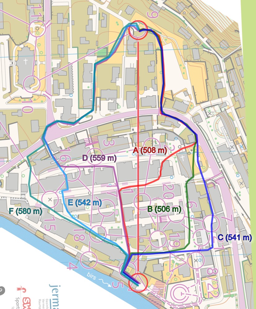
Today’s leg in Route to O-Season 2020 is another urban leg: Leg 9 in the M21E course from World Cup Sprint race in Switzerland autumn 2019.
This leg in was defining for the competition with the top 4 in total taking the top 4 places on the leg (although in different order).
The leg is as usually first provided without routes – you may take a look at it and think about how you would attack this leg (if the image is too small, you may click on it to get it larger):
![]()
Location
You find other maps from the area in omaps.worldofo.com here. See also latest additions in 3DRerun from this area in order to learn more about this terrain type.
Webroute
Next you can draw your own route using the ‘Webroute’ below. Think through how you would attack this leg, and draw the route you would have made. Some comments about why you would choose a certain route are always nice for the other readers.
Then you can take a look at how the runners have solved this leg below (from this analysis of the race by World of O). There are several choices both to the left and right – clearly going left is significantly slower, however, with the runners running left losing 20+ seconds. The reason for left being that much slower is maybe not obvious at first sight as the length difference is moderate (35-40 meters slower for the shortest variant to the left compared to the shortest to the right). However, the fact that left has more sharp corners and bends (more breaking/acceleration gives time losses), several of the streets are very narrow (slower running speed, less time to read map) and some extra stairs on the shortest variants (slower running) contributes to the significant time difference. You can, however, also lose time on the alternatives to the right if you choose the wrong one.

Density map
See below for a density map of some of the ones who have drawn their routes so far (available during the day when some readers have drawn their route).
![]()
Additional information
You find the complete map in omaps.worldofo.com at this location.
Route to O-Season 2020 series
Route Choice Challenges while waiting for the real action: With the upcoming orienteering season indefinitely on hold in large parts of the the world due to COVID-19, regular orienteering route choice challenges may be one way to make sure those orienteering skills don’t get completely rusty. I’ll try to keep these coming daily, but need help from all of you out there to keep them coming and to keep up a certain quality.
Tips on good route choice challenges – either from races/trainings (even cancelled ones) or theoretical ones with accompanying analysis – are very welcome (please e-mail to jan@kocbach.net).
Not all legs are taken for the interesting routechoice alternatives – some are also taken because the map is interesting – or because it is not straightforward to see what to do on a certain leg. Any comments are welcome – especially if you ran the event chosen for todays leg!


Jan, do you realise that route B crosses olive green next to the church about half way – you would have to go a bit further east to the blue route which would add a few extra metres to B.
Some of the routes are shown crossing the olive green but that could be due to poor GPS coverage. Or did runners jump over the olive green (presumably a narrow flower bed) and if so is it considered ‘legal’ to do that – if you do not actually set a foot down?
Thanks, Rob, good catch. That does add a few meters indeed, sorry about that. The general analysis is (luckily) still valid, though.
Actually the few metres doesn’t change the analysis.
I was more interested in the fact that it looks like many GPS tracks crossed the olive area. The tracks all seem to be follow a similar line so I doubt it can be explained away as inaccurate GPS in urban terrain – if that were the case I would expect more randomness in the tracks.
It reminds a bit of the World Cup middle in China where a similar thin strip of olive green caused so much angst.
No, jumping over a flower bed, or even just cutting across a corner without stepping inside it, is still clearly illegal.