 World of O News
Today’s leg in Route to O-Season 2020 is a small celebration of the Norwegian “Mapant-project” – an orienteering map covering large parts of Norway following in the footsteps of mapant.fi for Finland. The first version of Mapant.no, covering around 50% percent of Norway, is set to be published before summer.
Read more about the Norwegian version of Mapant at orientering.no (Norwegian language).
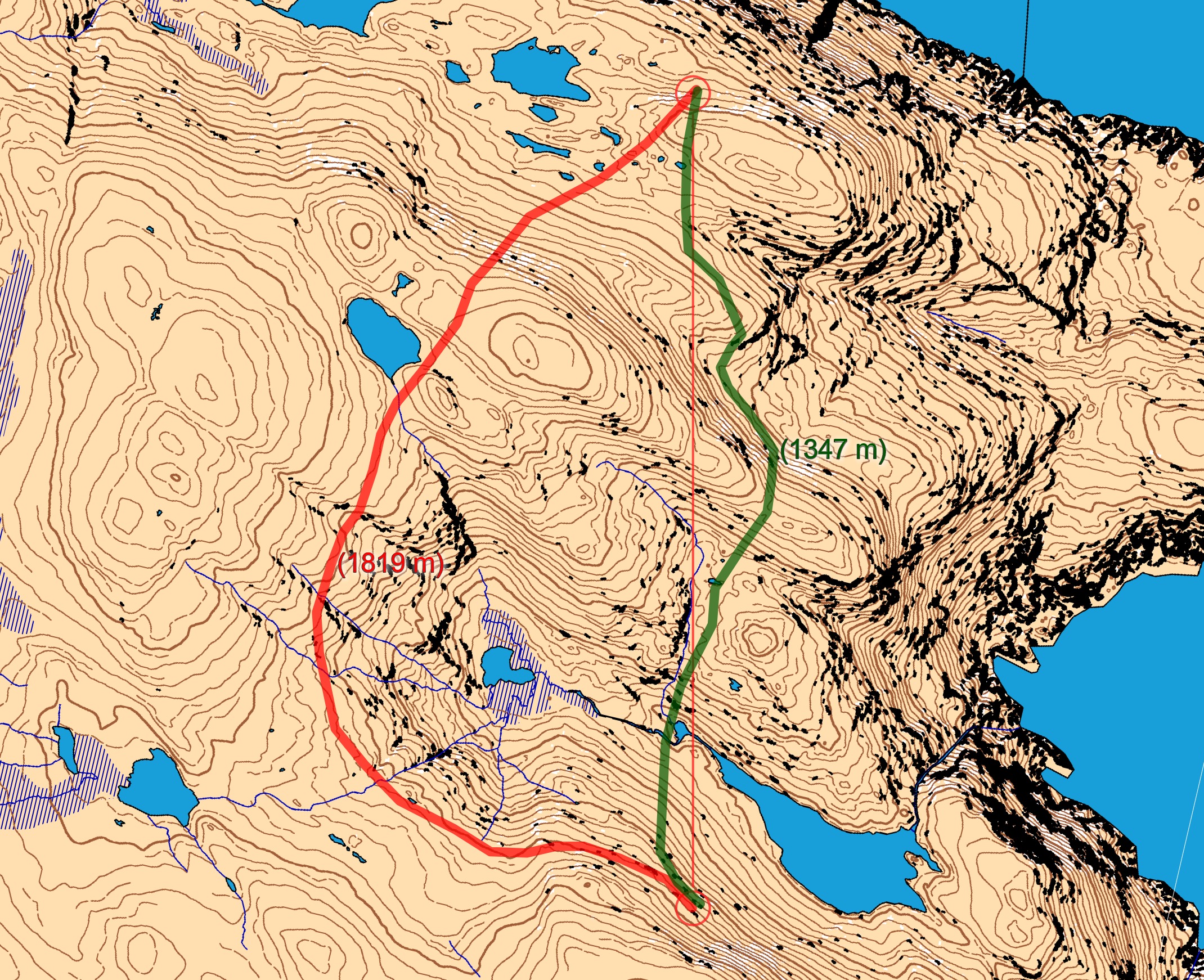
The leg chosen as the first from Mapant.no is a leg from the North Cape area, just south-west of North Cape (the closest map in omaps is as much as 80 km away). This is open area without vegetation, so climb and steepness is the main differentiation between the routes. The 1.2 km long leg is as usually first provided without routes – you may take a look at it and think about how you would attack this leg (if the image is too small, you may click on it to get it larger). As no runners have been running this leg (yet), please add some comments for the analysis!
![]()
Location
You find other maps from the area in omaps.worldofo.com here. See also latest additions in 3DRerun from this area in order to learn more about this terrain type.
Webroute
Next you can draw your own route using the ‘Webroute’ below. Think through how you would attack this leg, and draw the route you would have made. Some comments about why you would choose a certain route are always nice for the other readers.
Then you can take a look at how the runners have solved this leg below. I would say going around should be the best choice here (and maybe it is too obvious?). Straight is less than 500 meters longer, and ou save some quite steep hillsides, both downhill and uphill. What do you think?
Density map
See below for a density map of some of the ones who have drawn their routes so far (available during the day when some readers have drawn their route).
![]()
Route to O-Season 2020 series
Route Choice Challenges while waiting for the real action: With the upcoming orienteering season indefinitely on hold in large parts of the the world due to COVID-19, regular orienteering route choice challenges may be one way to make sure those orienteering skills don’t get completely rusty. I’ll try to keep these coming daily, but need help from all of you out there to keep them coming and to keep up a certain quality.
Tips on good route choice challenges – either from races/trainings (even cancelled ones) or theoretical ones with accompanying analysis – are very welcome (please e-mail to jan@kocbach.net).
Not all legs are taken for the interesting routechoice alternatives – some are also taken because the map is interesting – or because it is not straightforward to see what to do on a certain leg. Any comments are welcome – especially if you ran the event chosen for todays leg!


I think I disagree, I’m counting 13 curves to climb in the “flat left” alternative compared to 23 for the “straight”. 50 m extra climb for 502 meter saved length is usually worttwhile (factor 7 meter length per meter climb). As long as the steep descent on the straight route is not very slow, straight should be faster. I am guessing 15-45 sec. But due to saved energy, it might be wise to go around on a long distance race any way.
I believe that the hillsides are so steep on the direct route that the factor 7 is not valid; for the very steep parts you should probably increase this significantly. I am aware that there is quite much climb around, but it is a lot more gradual ….
I agreed with my brother here but I entered a route slightly further left than the consensus straight option because that made it possible to save one or two contours in the first valley, and then later on distribute the climb even more. I do agree that long (30-60 m ascent) steep climbs slow you down more unless your name is Olav Lundanes so if possible I try to split them into stages of not more than 20-30m. OTOH, as Knut mentioned, if this was a long race going around might save important energy even if costing a bit of time on the leg.