 World of O News
Today’s leg in Route to O-Season 2020 is another sample from the Norwegian Mapant-project. This time we travel all the way to the southern edge of Norway, to Lindesnes.
Note! There may be “real” orienteering maps in this area, but I could not find any recent ones.
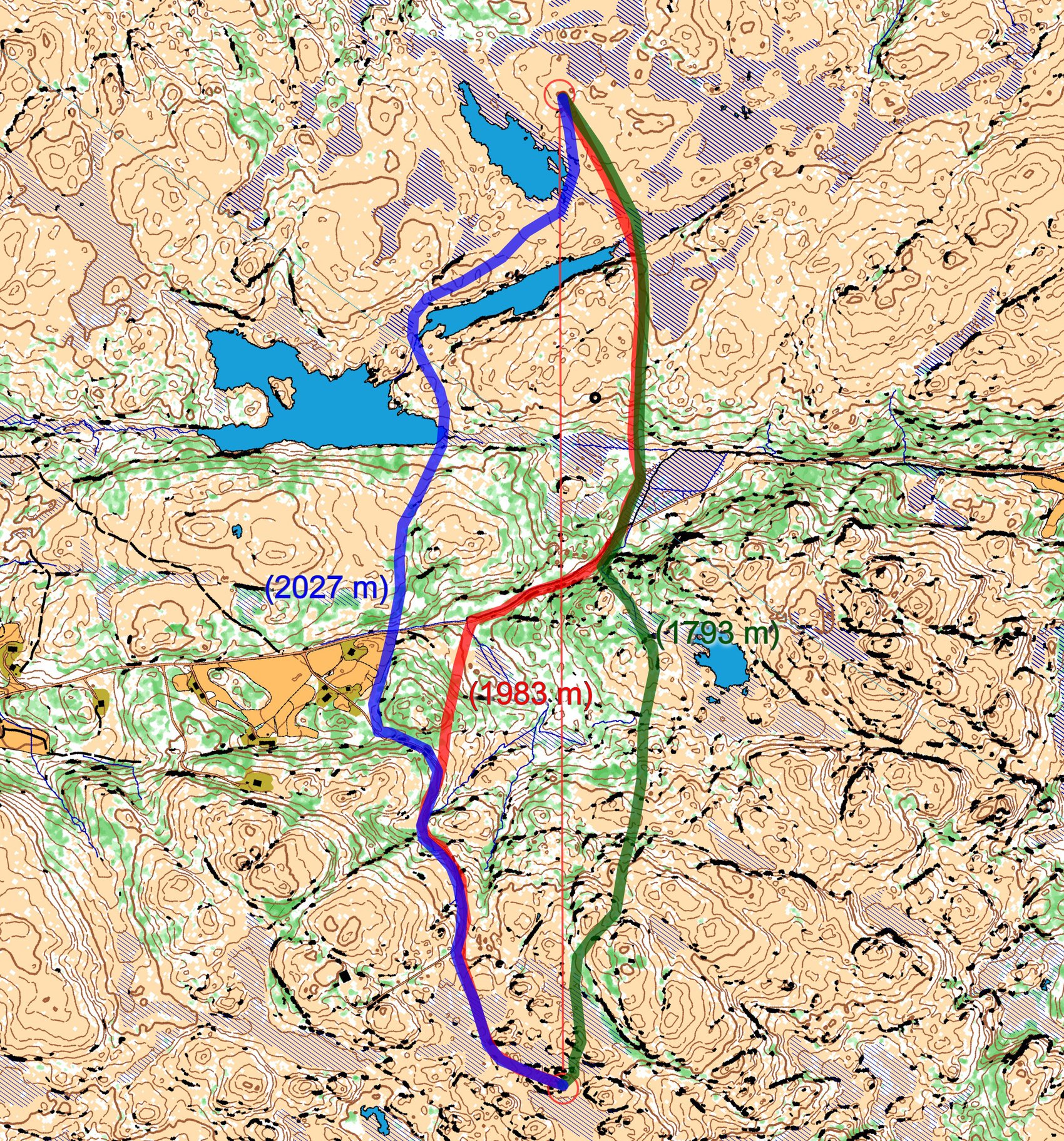
The leg is as usually first provided without routes – you may take a look at it and think about how you would attack this leg (if the image is too small, you may click on it to get it larger). As there is no analysis from people running this leg, please add a comment with your analysis!
![]()
Location
You find other maps from the area in omaps.worldofo.com here. See also latest additions in 3DRerun from this area in order to learn more about this terrain type.
Webroute
Next you can draw your own route using the ‘Webroute’ below. Think through how you would attack this leg, and draw the route you would have made. Some comments about why you would choose a certain route are always nice for the other readers.
I have drawn three possible route choices on the map – there are several other alternatives. I believe an S-shape (first left then right) is the fastest on this leg. Either red or a combination of blue and red. Then you get acceptable runnability and can make the orienteering fairly straight forward. What do you think?
Density map
See below for a density map of some of the ones who have drawn their routes so far (available during the day when some readers have drawn their route).
![]()
Additional information
You find the complete map in omaps.worldofo.com at this location.
Route to O-Season 2020 series
Route Choice Challenges while waiting for the real action: With the upcoming orienteering season indefinitely on hold in large parts of the the world due to COVID-19, regular orienteering route choice challenges may be one way to make sure those orienteering skills don’t get completely rusty. I’ll try to keep these coming daily, but need help from all of you out there to keep them coming and to keep up a certain quality.
Tips on good route choice challenges – either from races/trainings (even cancelled ones) or theoretical ones with accompanying analysis – are very welcome (please e-mail to jan@kocbach.net).
Not all legs are taken for the interesting routechoice alternatives – some are also taken because the map is interesting – or because it is not straightforward to see what to do on a certain leg. Any comments are welcome – especially if you ran the event chosen for todays leg!


Made me wondering, what is the black line beside the road in Day 99 problem (at your red route choice, at halfways of the leg)? Usually the black line is a forest road but here the blue ditch is connected to it.
Tapio: This is a river, but it is so thin that you don’t see the blue interior. We should draw this in another way, thanks for bringing it up.
Thanks for bringing the Mapant project to the attention of more people. It is fascinating. The drawn quality looks very good. It will be interesting to see how mappers manage to integrate other data sources like drone surveys that were used in the map making for the Swiss O week in 2019. It also be very interesting to hear people’s comments when they have run on these types of maps and tested them.
Maybe we will get used to two types of orienteering technique, learning to run on these maps and also continuing with normal orienteering maps.
Duncan, I have been working on this project for over 3 years now, since I took over as leader of the Norwegian Mapping Commission, and before this I worked on the base maps for JWOC 2015 and WOC2019 so I have spent a lot of time on machine-generated maps: The orienteering technique is actually very similar, the main difference being that you have much less tiny details (boulders are totally missing, ditto small marshes, and the path system is extremely variable but usually quite bad unless we have open yellow areas like here. OTOH the contour detail is _very_ good, cliffs and vegetation might not be complete but when you see one on the map it is usually quite obvious in the terrain as well.
When using my own base maps I usually have 1m form lines visible as well, in which case you can use those to see every single little terrain feature.