 World of O News
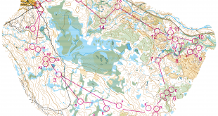
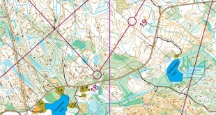
In today’s edition of Route to Christmas we travel to Australia to a leg featured at the second day of Australia 3 Days 2021 last easter.
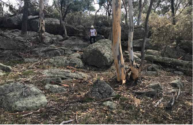
The competitors were challenged physically, technically, and mentally by some of the best granite terrain and – according to the organizers – one of Australia’s best granite maps.
The leg is as usually first provided without routes – you may take a look at it and think about how you would attack this leg (if the image is too small, you may click on it to get it larger):
![]()
Location
You find other maps from the area in omaps.worldofo.com here. See also latest additions in 3DRerun from this area in order to learn more about this terrain type.
Webroute
Next you can draw your own route using the ‘Webroute’ below. Think through how you would attack this leg, and draw the route you would have made. Some comments about why you would choose a certain route are always nice for the other readers.
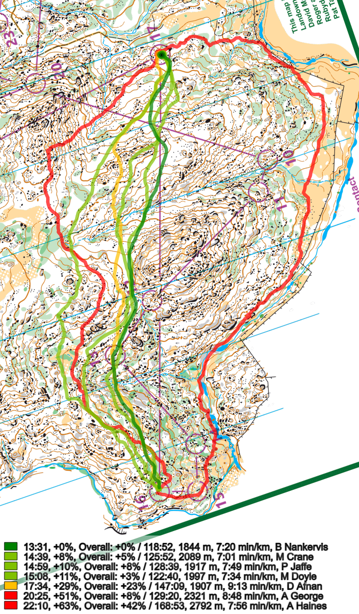
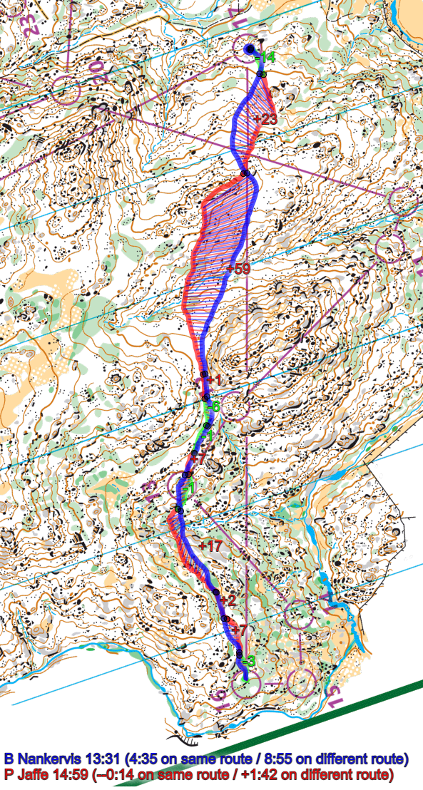
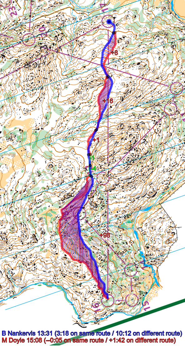
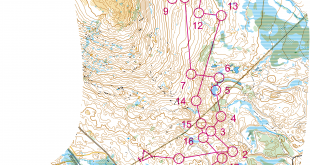
Then you can take a look at how the runners have solved this leg below. There were only 7 runners with GPS-tracking on this leg – and only one of them taking the route to the right, so it is difficult to know from the GPS-tracking if going around to the right might be a good option. However, as all the best orienteers chose to run to the left, this is probably the best choice here.
Of the various left/straight choices, it looks like key here is to avoid the stony areas and areas with cliffs, and also avoid extra climb – in addition to running as sort as possible. This is typically a leg were good execution is key – and to execute well you need to choose a route where the orienteering is not too difficult. This definitely looks like a leg which it would have been a lot of fun to run!
Density map
See below for a density map of some of the ones who have drawn their routes so far (available during the day when some readers have drawn their route).
![]()
Additional information
You find the complete map in omaps.worldofo.com at this location.
Route to Christmas series
The Route to Christmas series is a pre-Christmas tradition at World of O – giving the readers the opportunity to do one Route Choice Challenge each day from December 1st until December 24th. If you have got any good legs in GPSSeuranta or 3DRerun from 2021-competitions, or old forgotten ones which are still interesting, please email me the link at Jan@Kocbach.net, and I’ll consider including it in Route to Christmas if it looks good. Route to Christmas will not be interesting if YOU don’t contribute.
Not all legs are taken for the interesting routechoice alternatives – some are also taken because the map is interesting – or because it is not straightforward to see what to do on a certain leg. Any comments are welcome – especially if you ran the event chosen for todays leg!
Map location shows Italy :)
Thanks! Fixed now…
Thanks for the entertainment! Agree to your comment, too, not a lot of climb to save by going right and it is very long, and left saves very little climb, is longer and depending on exact route, have worse runnability. Small typo, h missing in “in addition to running as sort as possible”.
Knut
As course setter I can say you are pretty much correct. The right route comes into play because the runnability by the fence and the river to the right is generally good and it’s a long way in to a very tough elite course which might encourage some tired runners to take the easy way out of 16. But it’s a bit of a trap because the approach to the control from the right is very slow. Jan’s comments about execution are correct too. Also worth mentioning if running straight, approaching the control is quite tricky down the hill even though the visibility isn’t bad in this part. It’s very easy to make a parallel error here.
I’m surprised though that the best route runs through control 13. I would have stayed higher above 13, contouring around the valley to stay in the band of white with no rock or stony ground (roughly Matt Doyle’s route). Staying out of the rocky ground is normally important. Matt probably didn’t execute this perfectly but it’s still clearly slower than Brodie who cut across the main gully through the green and past 13.
The terrain is quite fantastic. An interesting story I was told about this area which readers might find amusing. This terrain was used as a model area for JWOC 2007. The story goes that on the plane to Australia for a training camp a copy of the map was handed around by the Norwegian coach. The map stopped with Olav Lundanes who studied it for the next 8 hours and refused to hand it over to anyone else. Perhaps Olav could confirm if this is true (or not) if he reads this :-)
Thanks, Eric – great to hear from you! And nice to hear that the analysis was not completely off. I’ve never been in this type of terrain, but I’d really love to try it some time.
I have run in this terrain. Looking at that leg I looked for possible left and right routes but very quickly disregarded them. Left was just longer but no easier running and no easier navigation. Right seems like easier navigation for most of the leg but the approach to the control was only marginally easier than going straight. And actually running straight there were large contour features (valley saddle valley ridge) to navigate by most of the way so it was only the last part (down from the ridge) that was actually difficult navigation. While right looked more runnable (lots of running in yellow) I don’t think it was that much better running. The map looks very rocky but actually (if I remember that terrain accurately) except for the most extreme rocky areas the terrain is quite fast – between the large boulder clusters and cliff formations the terrain is very runnable – there is usually not that much scattered small rocks that would slow you down. So while running right offered slightly better runnability it was not nearly enough to compensate for the extra length. The only real route choice decisions in my mind were micro route choices – variations on ‘straight’.
I was not surprised that the quickest route was the straightest (via 13). I can’t see any advantage in contouring round to the left there. At the very best you could save 3 contours (15m) but in practice it is hard to ‘contour’ accurately and you often drift up and own a bit and often don’t save the climb you think you would. Look at the comparison of Nankervis and Doyle – Doyle went left and might have thought he was saving climb, but in fact he didn’t save any climb at all (count the contours).
Also ‘contouring’ is an inherently risky technique as it requires constant subtle changes of direction – that might be easy in steeper terrain (where it easier to see the slope and follow it) but on a gentle slope like that it is hard to get it right (especially when there are so many rock features to get around and patchy green). It much easier (navigationally) and safer to go straight – just use your compass to aim for that huge saddle – no need to read any detail on the map. Contouring requires you to read the map much more closely. Not worth it for just 3 contours.
Also the difference in rockiness and greenness between the straighter route (via 13) and contouring seems negligible to me (perhaps you need to have run in this sort of terrain before to realise that). At first glance the straight route does seem a bit greener – but it is patchy so I don’t think it would slow you down. Again if you compare Doyle’s route to Nankervis (near 13) , Doyle’s longer route doesn’t actually look any less rocky to me.
The forest has thickened up considerably since the 2000s (which makes it an even more technical area than it was, because of the lower visibility). I don’t think that greatly changes the balance of options on this leg, though.