 World of O News
Today’s leg in Route to Christmas 2021 is the last sprint leg in this year’s edition of Route to Christmas. This time we travel to Estonia to the Estonian Championships sprint.
Thanks a lot to Uku-Laur Tali for the tip! Uku-Laur Tali was the head organizer while the course setter was Eduard Pukkonen.
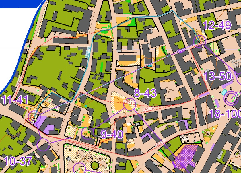
The leg is as usually first provided without routes – you may take a look at it and think about how you would attack this leg (if the image is too small, you may click on it to get it larger). The leg was used in both the women’s and men’s class.
![]()
Location
You find other maps from the area in omaps.worldofo.com here. See also latest additions in 3DRerun from this area in order to learn more about this terrain type.
Webroute
Next you can draw your own route using the ‘Webroute’ below. Think through how you would attack this leg, and draw the route you would have made. Some comments about why you would choose a certain route are always nice for the other readers.
Here is the route comparison provided by Uku, including route lengths. As Uku writes:
As there is no climb to take account for then it is quite straightforward to choose the shortest route (blue). Still it was not as easy while running and not many runners saw it. Perhaps the first part through the gates and narrow passage seemed too slow. Also the southern route might seem easier and faster.
Then you can take a look at how the runners have solved this leg below (first women, then men):
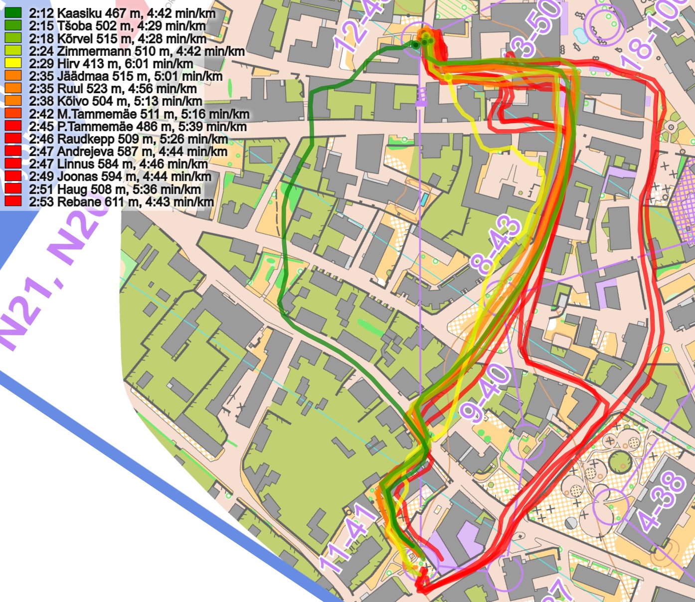

Again some comments from Uku:
For the men the fastest was Kenny going for the southern route but he was also the fastest runner in the field that day. Sergei was only 1 sec behind him on the shortest route. For the women the benefit was more clear.
Originally in the terrain there is actually a very small gap in a wall in this place (red):
Density map
See below for a density map of some of the ones who have drawn their routes so far (available during the day when some readers have drawn their route).
![]()
Additional information
You find the complete map in omaps.worldofo.com at this location.
Route to Christmas series
The Route to Christmas series is a pre-Christmas tradition at World of O – giving the readers the opportunity to do one Route Choice Challenge each day from December 1st until December 24th. If you have got any good legs in GPSSeuranta or 3DRerun from 2021-competitions, or old forgotten ones which are still interesting, please email me the link at Jan@Kocbach.net, and I’ll consider including it in Route to Christmas if it looks good. Route to Christmas will not be interesting if YOU don’t contribute.
Not all legs are taken for the interesting routechoice alternatives – some are also taken because the map is interesting – or because it is not straightforward to see what to do on a certain leg. Any comments are welcome – especially if you ran the event chosen for todays leg!


I’m not sure, but it seems like the combination of very narrow pavement and equally narrow grass in the opening on the shortest route make it significantly harder to spot. I assume both widths are according to ISSprOM?
Appropriate remark that is always something to keep in mind.
In this case the map was thoroughly inspected and this place among many others was exaggerated.
I like to use dedicated dots in mapping software to check the widths for that purpose (0,15mm and 0,4 mm in this case).
Unfortunately I cannot post pictures in the comments here but the dots fitted to this passage nicely.