 World of O News
For today’s Route to Christmas we travel far away from Europe – to Blue Mountain and the US Timetrails long distance. – Blue Mountain is lovely terrain. The forest floor is largely clear, with very little rock or vegetation underfoot for the most part, course setter Neil Dobbs explains. – Visibility is also pretty good, but the terrain can resemble itself so if you lose contact it can be tricky to relocate in some areas.
– There used to be a lot more green on the map corresponding to groves of hemlock trees (a type of pine), Dobbs explains.
– These got attacked by a woolly adelgid and died and decomposed, so there are some remnants of dead trees, but mostly the runnability is excellent, and the best it has been in many years.
Channels to run along
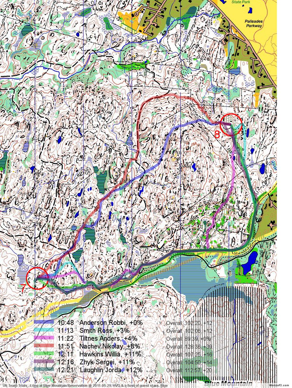
Todays leg in Route to Christmas is leg 8 in the Blue course. The leg is as usually first provided without routes – you may take a look at it and think about how you would attack this leg (if the image is too small, you may click on it to get it larger). When considering which route to choose, take these words from Neil Dobbs into account: – The terrain is quite steep. The features are big – one-contour hills are usually 5-7m. It is important to find channels to run along where you don’t cross too many brown lines, both for speed and for ease of navigation. The small paths are usually MTB trails and not always designed to take the shortest path.
![]()
Webroute
Next you can draw your own route using the ‘Webroute’ below. Think through how you would attack this leg, and draw the route you would have made. Some comments about why you would choose a certain route are always nice for the other readers.
Then you can take a look at how the runners who have drawn their route choice solved this leg. The course setter has made the following short considerations about the leg:
Judging by the results, Robbie nailed it. Anders’ route probably involves too much climb compared to continuing further along the path in the yellow. Nikolay’s route is nice, but I think in this case it is worth sucking up the climb to stay closer to the line, like Robbie did. There is an over-the-top route too, probably too much climb for a long race.
Bonus leg
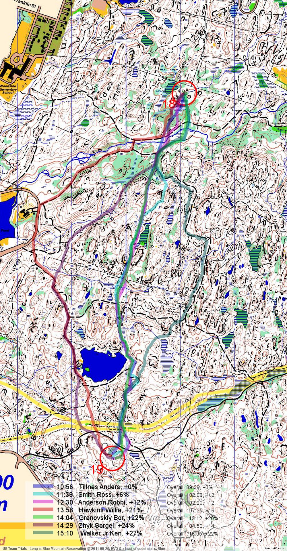
It being the 15th December and all, we provide a Bonus leg today! This is leg number 19 from the same event. The leg is as usually first provided without routes – you may take a look at it and think about how you would attack this leg (if the image is too small, you may click on it to get it larger):
![]()
Webroute
Next you can draw your own route using the ‘Webroute’ below. Think through how you would attack this leg, and draw the route you would have made. Some comments about why you would choose a certain route are always nice for the other readers.
Then you can take a look at how the runners who have drawn their route choice solved this leg. Dobbs’ analysis:
The route chosen by Anders, Robbie and Ross follows a channel in the terrain. The running is good, the navigation reasonably straightforward, the climb isn’t bad and I think it is a clear winner, if not *immediately* obvious that this is so on the map.
Complete map in Omaps.worldofo.com
You find the complete map and Routegadget info in omaps.worldofo.com at this location.
Omaps.worldofo.com
The ‘Route to Christmas’ series at World of O has been very popular the last years – and I’ve therefore decided to continue the series this Christmas as well. If you have got any good legs in RouteGadget from 2011-competitions – or old forgotten ones which are still interesting – please email me the link at Jan@Kocbach.net, and I’ll include it in Route to Christmas if it looks good. Route to Christmas will not be interesting if YOU don’t contribute.
There will be no analysis about the best routechoice for each leg – you can provide that yourself in the comments or in the Webroute. Not all legs are taken for the interesting routechoice alternatives – some are also taken because the map is interesting – or because it is not straightforward to see what to do on a certain leg. Any comments are welcome – especially if you ran the event chosen for todays leg!
Note that there may be some errors in the Routegadget data (sometimes somebody draws a route for another runner just for fun). Please add a comment below if you spot en error.


Hi Jan:
Your density maps were very instructive. I miss them. Is it a lot of work to produce these maps?
Making the density maps is fast. However, some people started drawing obscenities, stars, their names etc. as their routes. Thus I sometimes can’t publish the density maps as I have no easy way to remove a route, and it would also take a lot of time to identify which of the 3-400 routes must be removed. It is a pity, because I really liked those density maps as well. Somebody always has to ruin something that is good…
okay i am sorry, i admit ive drawn some bad things… i will not do it anymore, i miss the density maps too