 World of O News
Today’s leg in Route to Christmas is the major leg of “The Course of the Year 2015” – the M21 course in the World Championships Long distance in Scotland.
Accompanying today’s Route to Christmas is an analysis of the leg by World Champion on this very course Thierry Gueorgiou – and Frederic Tranchand who ran the second fastest time on this leg. Both chose this leg as their candidate for “Route to Christmas” – a big thank you to both of them for their analysis! Of course many of the readers might already have seen an analysis of the leg – still this leg is definitely worth revisiting with the comments of two of the big masters.
As the longest leg of probably the most important individual race of the year, it makes the route decision crucial
– One of my best memories from 2015 as an orienteer
– I’ve chosen this leg not exclusively due to the technical aspect, Frederic Tranchand explains his choice of the leg from the World Champs as his candidate for “Route to Christmas”.
– It was so marvelous over there that it made this place magical, and certainly one of my best memories from 2015 as an orienteer, Tranchand continues. – Secondly, as the longest leg of probably the most important individual race of the year, it makes the route decision crucial.
– As the longest leg of the whole course, there is, of course, a big risk of time losses for the ones taking the wrong route-choice, but also an opportunity to use the physical strength in a long period without searching for a control, so a chance to “win” time to others.
… an opportunity to use the physical strength in a long period without searching for a control, so a chance to “win” time to others
Finally about the terrain and the preparations:
– We have spent quite a lot of time in training camp in Scotland before the championship, but this terrain was actually relatively special. For me, almost the only experience of this type of terrain dated back from 2010 when we trained for the WOC in Trondheim. I had kept a very good impression of it even if I was young and only selected for the sprint back then…
The leg is as usually first provided without routes – you may take a look at it and think about how you would attack this leg (if the image is too small, you may click on it to get it larger):
![]()
Location
You find other maps from the area in omaps.worldofo.com here. See also latest additions in 3DRerun from this area in order to learn more about this terrain type.
Webroute
Next you can draw your own route using the ‘Webroute’ below. Think through how you would attack this leg, and draw the route you would have made. Some comments about why you would choose a certain route are always nice for the other readers.
Then you can take a look at how the runners have solved this leg below.
Analysis by Thierry Gueorgiou:
The simple route to the control 12 made the preparation of this long leg easier and I had already in mind to avoid the steepest slope, right after the control, from the left side. During the many training camps prior WOC, we had realized that the steep climbs in the heather were really really slow and highly energy-consuming. But I had probably too much free time, and started to evaluate another and straighter route. I could sense it was one of the last tough and hilly legs of the course, and it could be the right time to press the speed pedal a bit more. And I started to see lot of small and dry (in a Scottish point of view…) plateau in the right side of the leg and convince myself that there might be some fast running there.
During the many training camps prior WOC, we had realized that the steep climbs in the heather were really really slow and highly energy-consuming
Already 200 meters after the 12th control, I knew I had made a miss-evaluation. I was stuck on the slope, crawling into high heather. I had a quick look if I could jump back in my original plan, but it didn´t make sense anymore. Instead, I tried to push hard to get to the top.
Already 200 meters after the 12th control, I knew I had made a miss-evaluation
The second annoyance came slightly after, when I started crossing the green hatches. As one of the very last starters, I was expecting some small tracks there, but I saw a “wall” of fern facing me. 1 or 2 minutes of fighting which seemed lasting forever. I had a hard time controlling my thoughts at this moment, and I saw my chances of winning this race decreasing seconds by seconds. But finally, I got through it and reached those flatter areas. I knew I had lost time, which adds up to my mistake at number 4, but I had no idea if I would see the back of Magne Daehli (starting 3 minutes behind me), or if I still had a chance in this race.
I had a hard time controlling my thoughts at this moment, and I saw my chances of winning this race decreasing seconds by seconds
The last part of the leg brought back some calmness as the white open forest was considerably faster. At least, at this moment of the race, I knew that I had to run perfectly up to the end and stop gambling.
Analysis by Frederic Tranchand:
This leg came rather early in the race but after a first part partly on a very rough terrain and with some tough uphill (especially around the 9th control).
- Based on this you really want to choose a route where you don’t use too much energy. This means a choice with as little uphill as possible, as close to the straight line as possible. The main thing to look at when taking your choice is the runnability: It was rather hard to predict how it would be on the terrain when looking at the map. How soft is the ground? How high is the undergrowth?
- Secondly, if you want to run fast, the navigation should not be too tricky and the control safe to attack. The open terrain from the left with the big marches, the lake, and the big hills allow you to be quite efficient.
Taking this into account, the left option looked the best for me without much hesitation. If I remember correctly, I decided on this route already on my way to the 9th control. The only important thing to do during the navigation was to keep the right direction – and that was rather easy thanks to the good visibility.
It was also the place where the runners could see the mountains and the wild nature around that was really special
During the leg, the navigation was indeed rather easy with a good visibility. It was also the place where the runners could see the mountains and the wild nature around that was really special. For the little anecdote, it was the first time I caught sight of Magne Daehli who started before me. He was still quite far away (good visibility) but I could still compare our running times and understand that I was leading on him.
Analysis by course-setters:
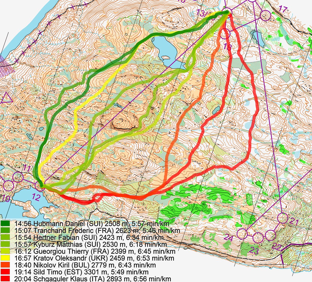
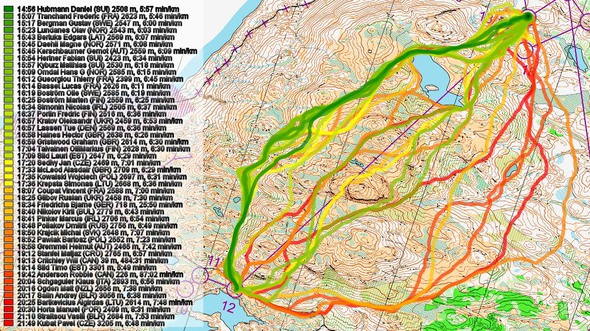
Women’s 4-5 and Men’s 12-13 was a similar leg from the TV control to different end controls about 100 meters apart. Though most competitors followed a route to the left similar to the fastest Woman (Alexandersson in 18:13 for 2559m) and Man (Hubman in 14:59 for 2526m) which has 2 major contours plus of ascent (but under 75m, for a climb adjusted distance of about 3100m) , there were many others including some top favourite medal contenders who opted to go more direct (with 2 extra major contours, 50m more climb) or even taking a “around the hill” route that minimized climb but with extra distance. (On the mens Sild going right 3324m and taking 4m24s longer, and on the womens Rantanen goes left for a route of 2.7km with potentially less than 2 major contours, but she heads uphill and adds nearly 25m of climb compared to staying level ).
The time differences were significant for the women, many favourites losing their chance here, but not so great for the favourite men – though the overall winner (Gueorgiou) had his worst split being 1m12s behind Hubman (Gueorgiou almost ran in the footsteps of Dambe on the womens course – but he was alone – the top men started after the last top woman, and the men had a longer section before the long leg over the hill.) Gueorgiou’s route though shorter had another major contour (climb adjusted distance of about 3.2Km), and also had a very steep climb at the beginning which would have been energy inefficient – slow progress at a high energy cost.
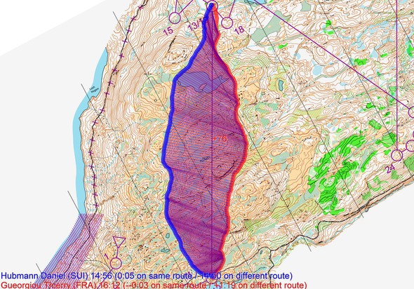
Density map
See below for a density map of some of the ones who have drawn their routes so far.

Additional information
You find the complete map in omaps.worldofo.com at this location.
Route to Christmas series
The Route to Christmas series at World of O has been very popular the last years – giving the readers the opportunity to do one Route Choice Challenge each day from December 1st until December 24th. If you have got any good legs in RouteGadget, GPSSeuranta or 3DRerun from 2015-competitions – or old forgotten ones which are still interesting – please email me the link at Jan@Kocbach.net, and I’ll include it in Route to Christmas if it looks good. Route to Christmas will not be interesting if YOU don’t contribute.
Not all legs are taken for the interesting routechoice alternatives – some are also taken because the map is interesting – or because it is not straightforward to see what to do on a certain leg. Any comments are welcome – especially if you ran the event chosen for todays leg!