 World of O News
The future for orienteering on TV – if the goal is to attract a wide audience – will probably involve 3D Terrain Models. This will make broadcasts more spectacular, and it will also be easier to describe differences between routechoices to non-orienteers with limited orienteering map reading ability. – The broadcast was a success, but we will never again show an orienteering map when broadcasting orienteering on TV, the producer of the hour-long NOC 2005 live-broadcast on Norwegian TV2 said when summing up the future for orienteering on Norwegian TV as he saw it last autumn (read story here). WoO-TV has, in cooperation with Greg Walker/Catching Features, made the first real 3D production from an orienteering race – with birds’ eye perspective, featuring Thierry Gueorgious route to victory at the World Cup round 2 this year.

From orienteering map to 3D Terrain Model
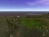
The first step to make productions with 3D Terrain Models of orienteering races, is to get a good 3D representation of the orienteering map. The orienteering game Catching Features fortunately does this conversion job automatically in a decent manner, directly from an OCAD file to a 3D Terrain model. An operator may use a number of settings to improve the conversion process, but even the default settings gives an acceptable 3D model.
The next step is to show selected routechoices using the 3D Terrain Model. The man behind Catching Features, Greg Walker, has done some very interesting work on using the Catching Features engine for this in cooperation with woO-TV / Jan Kocbach the last months. The first fruits of this work were shown at the Nordic Orienteering Championships (NOC) in Denmark this summer: A 3D representation of one of the decisive legs in the NOC relay was shown on Danish Television – the leg was shown in 3D as seen from the runners perspective.
Birds’ perspective
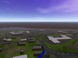
 Showing route choices from above – using birds’ perspective – rather than from the runners perspective as in the Catching Features game mode – was the next goal of the project. Just in time for the second World Cup round this year at Hovden (Norway), Greg Walker managed to finalize and send over a new version of Catching Features with an extra recording mode with possibility to capture routechoices from any perspective. In addition, the routechoice is shown as a solid «running» line in the 3D Terrain Model, like you have probably seen in e.g. TV broadcasts from Tour de France.
Test case: Thierry Gueorgiou at World Cup round 2
Thanks to a very cooperating Thierry Gueorgiou – and also the organizers of the World Cup in Hovden, Kristiansand OK providing the OCAD-file of the map, we got an ideal test case for the first real 3D production from an orienteering race. Gueorgiou – currently the best orienteer in the world – explains his routechoice to victory at the World Cup race in Hovden this June. In the 12 minute woO-TV production «Thierry Gueorgiou: Routechoice to Victory», Gueorgious routechoice is shown using a combination of traditional orienteering map, 3D Terrain Model, and some head camera action. Focus has been on showing what is possible to achieve with the technology and software available now, rather than on a full analysis of all details about the World Cup race in Hovden. Time to work on this production has been limited, so the final production has room for a number of improvements. But please try to look beyond these (I know of many of them myself), and look forward at the possibilities.

About the «Routechoice to victory» production
As written above, I received the new Catching Features version just in time for the World Cup at Hovden. The organizers Kristiansand OK proved very helpful, and provided me with an OCAD file with the map just after the World Cup race. Below, the steps to make the production are briefly outlined,
 The World Cup map was run through the Catching Features OCAD->3D Terrain Model translator. This was my first time trying to convert a real orienteering map, and I was surprised about how well the translator worked. I choose an automatic mode, and got a 3D Terrain Model out after the computer had worked for an hour or so. Granted, the vegetation does not look very similar to Hovden, but the heights look good, and that was the most important thing for me for this first test. Later I would like to focus on getting the terrain as similar as possible to the actual terrain – or alternatively go the other way, and make the terrain more generalized to make it easier to see certain features. Another thing I would have liked, is to get the controls more visible in the 3D Terrain Model. This should be easy, but I just don’t know how yet…
The World Cup course was set in Catching Features – a small and fast job to do. Next, the routechoice of Gueorgiou was drawn in Catching Features. A job a little more involved – taking maybe 20 minutes to perform. With some practice, I could have done it considerably faster. My hope for the future: Being able to import a routechoice from a GPS log – either from e.g. the Trac-Trac system or from Routegadget.- In the «Course review» mode of the special version of Catching Features I received, it is possible to directly record AVI’s showing the routechoice, from any chosen camera angle. This worked very nicely «right out of the box» from a static camera angle. What took time was to generate a flyover following the line representing the routechoice at the correct speed. After some hours of practice (which will be a good investment for next time I want to play Catching Features), I managed to fly quite nicely at an appropriate speed. Generating the required video clips was then no big deal.
- The remaining parts of the production were more straightforward. I have previously written a (perl/imagemagick-based) program which generates routechoices on a traditional orienteering map, e.g. used in the production about Simone Niggli-Luder at World Cup round 1. This was again applied for this production. Also, I got some head camera action to show something from the terrain at Hovden. Quality is not the best, as I did not get a map with the course until around 22h00 – when it was nearly dark, and the controls where gone. However, I found part of it interesting enough to include a bit of it anyway. And finally, I got to make the interview with Gueorgiou the day after the World Cup race, Gueorgiou explaining his routechoice and strategies.
- Clipping it all together and synchronizing the different parts with another took some hours, but I have got some practice at this now, so it is not really difficult. Next I’d like to get the head camera and a GPS synced, so that that part could be made close to automatically. We’ll see when and how that is possible…
- Finally: Music is – in my opinion – important to get the viewer in the correct mood for this type of a production. Getting access to music which has no strings attached to it is always difficult – and I am not completely satisfied with the music here, as it does not fit completely to the production.

What about the future?
I hope it will be possible to continue to work with Greg Walker to further adapt Catching Features for this kind of use. I guess it will partly depend on the response this production gets, suggested improvements, and so on. At least I think this is a good way to go for orienteering to maybe get a bigger TV sport – to attract new groups of viewers…
View the production – and give your comments below!
Please take a look at the production by pressing “Play” below. All comments regarding this projects are very welcome! Especially constructive suggestions regarding how to make this another step better! You can also go directly to the video page.
woO-TV: A success story!
The online TV channels for orienteering content – woO-TV – have now been live for 4 months – and has been getting all the attention we hoped for! Videos/productions from 16 countries have been shown on the 4 woO-TV channels – Norway, France, Denmark, Sweden, Austria, Finland, Latvia, Russia, Netherlands, Switzerland, Turkey, UK, Italy, Slovenia, Poland and Germany. The woO-TV channel has been written about in a number of websites, and it also got good publicity through the Jukola video competition which was hosted at woO-TV. In addition, woO-TV has given increased focus on orienteering related video productions, showing the way for others, and motivating more people to make their own productions.
The total number of video views – not including the views embedded on websites – has been close to 50.000 on the woO-TV channels (Veoh has up until now not counted embedded views – only views on veoh.com – while many view woO-TV embedded in the World of O webpage. Veoh will change this counting shortly, so we will be able to provide better statistics). Based on other statistics, the number of embedded views are around another 30-50.000 – and thus the total number of video views at woO-TV is probably around the 100.000 mark.
More information about these statistics – and the most viewed productions – will be available at World of O in the next weeks.
Go to
Fan-tas-tic job, Jan. Go ahead!
Just awesome…
Very good job!!
Saw your link to this on Attackpoint. Very impressive work. The catching features overhead view is pretty cool!
I had a little trouble following the action at high speed though. A few small suggestions…
– In CF view, float a big orange marker over the control… so we can see where he’s going. Also, slow it down a little.
– Do more anotation along the way, marking decision points, navigation points (attack points, catching features…) To make it really helpful, include short pauses to give the viewer a little more time to understand.
– I like how you flashed a highlight on features in Head-Cam view, to show where they are on the Map-Inset. You should do this with CF view too.
– I wasn’t able to follow the Map-Inset in conjunction with the CF view (it covered too little area, and moved too fast) It was useful when you used the highlighter to point out features though.
– I did like the Inset O-map in conjunction with head cam. It might help to keep the inset oriented.
Great work, great proof of method! If you can incorperate the competiton between multiple runners and craft a supsenseful story it will be even better.
Look at this company site http://pict-earth.blogspot.com/
They do something similar but in real. They use small airplane models with cameras and GPS and transmit the pictures in real time into Google Earth. I can imagine this can follow a runner that also has GPS…
What happened with this project? Is it too expensive to use for orienteering purpose? Has anybody seen the post race video beside on WOC screens or any comments after?
http://www.leica-geosystems.com/corporate/en/ndef/lgs_5044.htm