 World of O News
This is the headline for the trailer of Virtual-O – the upcoming orienteering game which the developer Peter Furucz aims to make more realistic than any other orienteering games or simulators out there. World of O wrote about Virtual-O six months ago – now big things are on the horizon for Virtual-O.
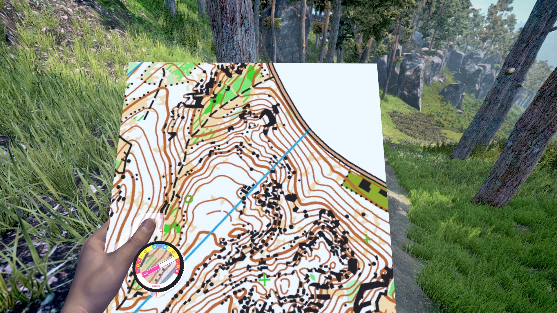
A lot of features have been added to the game – including forest undergrowth, LIDAR elevation data for terrain modelling, night and day orienteering modes, and a complex running speed model with running speed varying with map symbol, map reading length and slope. There is now a community testing early development versions of the game – giving regular feedback to make the simulation as realistic as possible. Below is an animated GIF which shows the night orienteering mode of Virtual-O.

Steam Greenlight campaign
Virtual-O has also launched a so-called Steam Greenlight campaign in order to try to attract regular gamers – and funding from outside the orienteering community. Developer Peter Furucz explains about the Virtual-O Steam Greenlight campaign.
– I think that it could be practically a life changer for Virtual-O and for orienteering itself too. It’s a way to get orienteering to masses.
– The Steam Greenlight campaign can change everything for Virtual-O. Steam is the biggest digital distribution platform for games and software. It has more than 125 million active users worldwide. Based mainly on how many users vote in a Steam Greenlight campaign, Steam will choose which games will be distributed.
Furucz gets excited when talking about the Steam Greenlight campaign. According to the Slovakian developer, this is the big possibility to get an orienteering game out to the masses.
– I think that it could be practically a life changer for Virtual-O and for orienteering itself too. It’s a way to get orienteering to masses. It looks like now is a time when a relatively small count of “Yes” votes is enough to get greenlit.
– Please vote for Virtual-O – and encourage your friends and family to vote for Virtual-O (Peter Furucz, developer)
– Probably 1500+ votes means a relative good chance. The campaign started yesterday, and we already have more than 250 yes votes. Please vote for Virtual-O – and encourage your friends and family to vote for Virtual-O [Editors comment: You can go here to vote for Virtual-O in the campaign. Only registered users who have invested 5$ on the platform to vote, but according to Furucz most people who play games are already on Steam and can vote.]
– The feeling of a natural, living forest is captured very well
Øystein Jahren Samuelsen is one of the alpha testers who has been test driving early versions of Virtual-O – and suggesting changes to how the game works on a closed Facebook group which the developer has set up for this purpose. Samuelsen likes the feeling of orienteering he gets when trying out the early development version of the game.
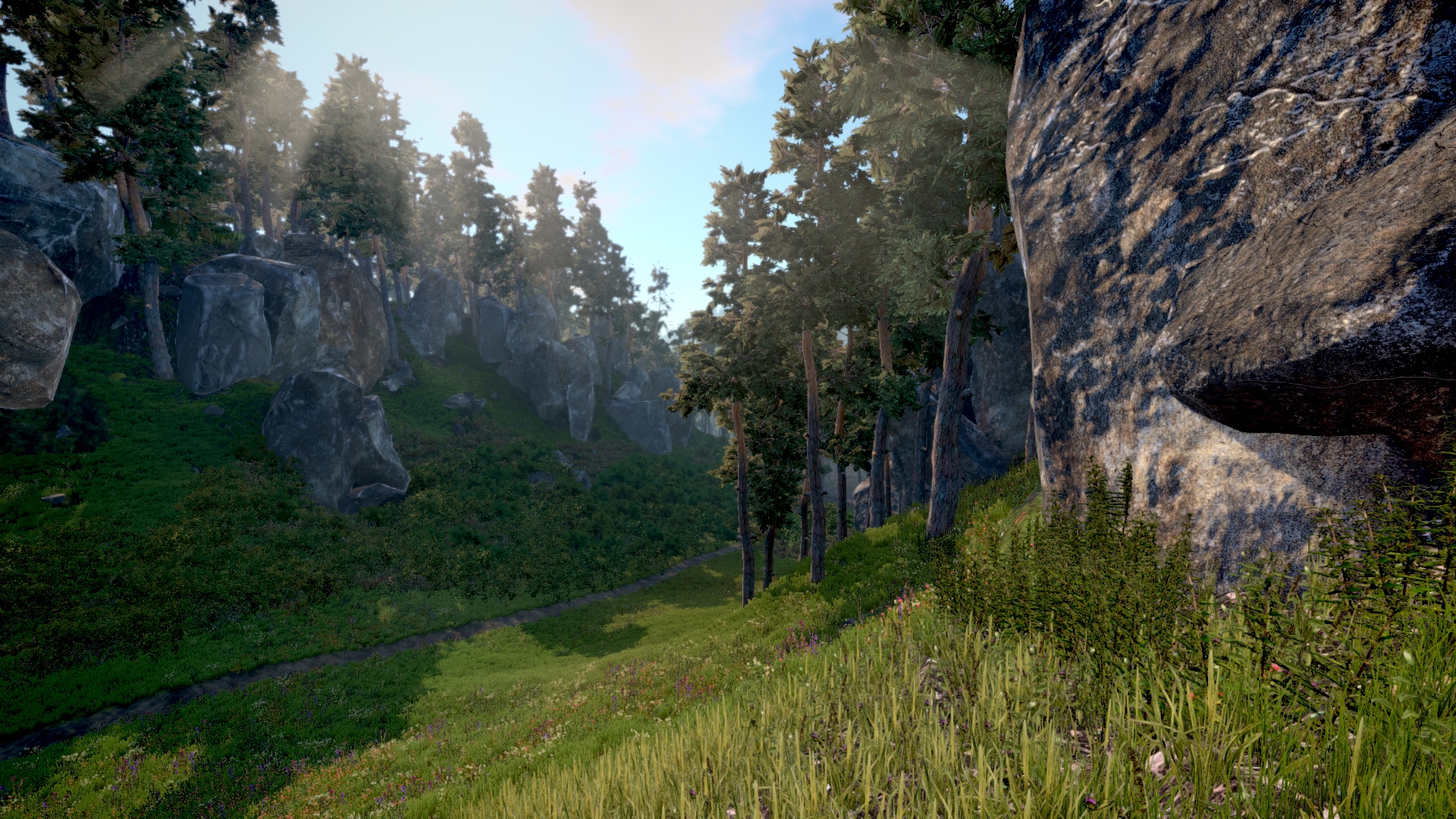
– The graphics are pretty much on par with what you can expect from a modern video game, and the feeling of a natural, living forest is captured very well, Jahren Samuelsen answers when asked about how realistic Virtual-O feels when running around in the terrain.
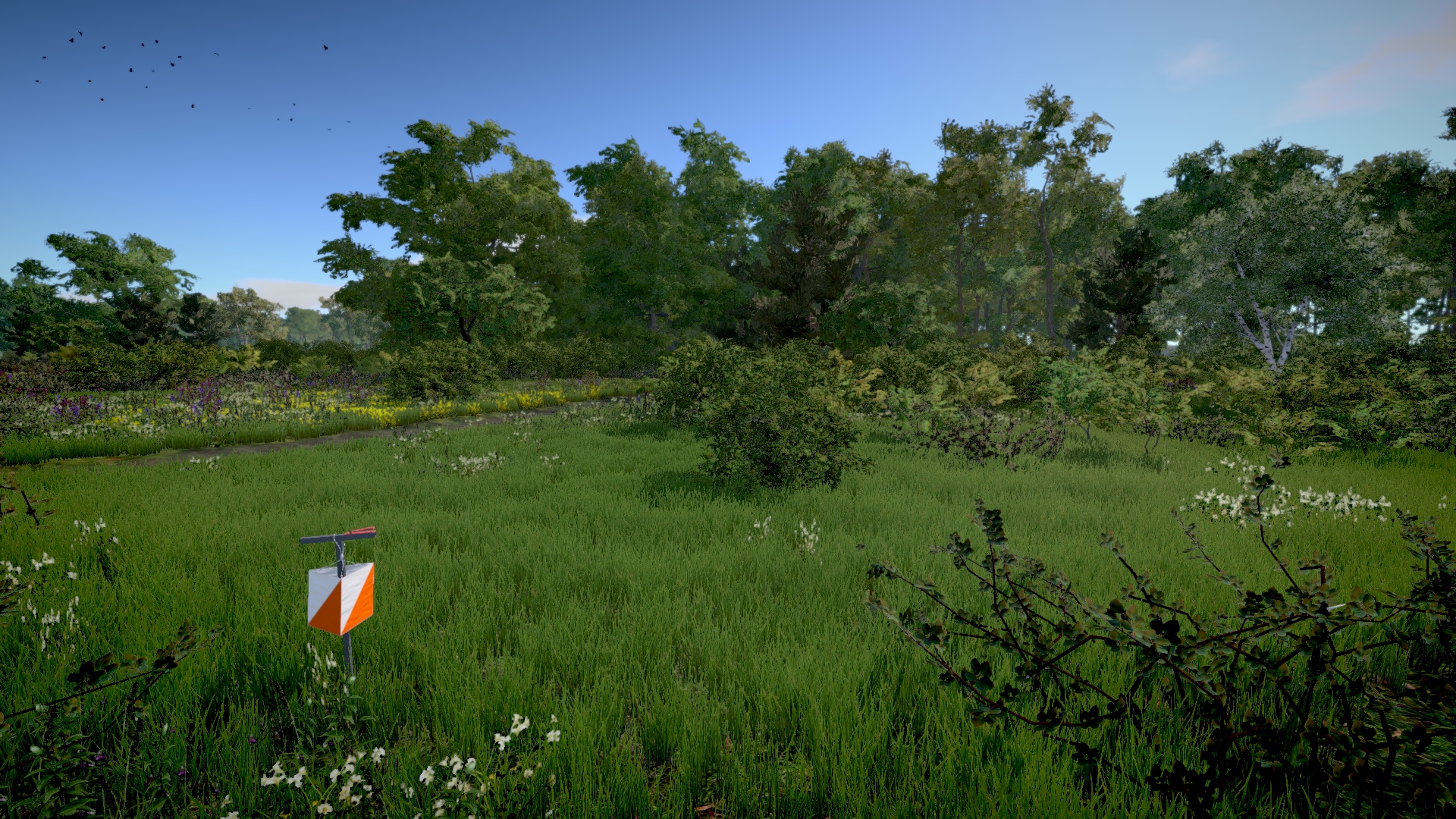
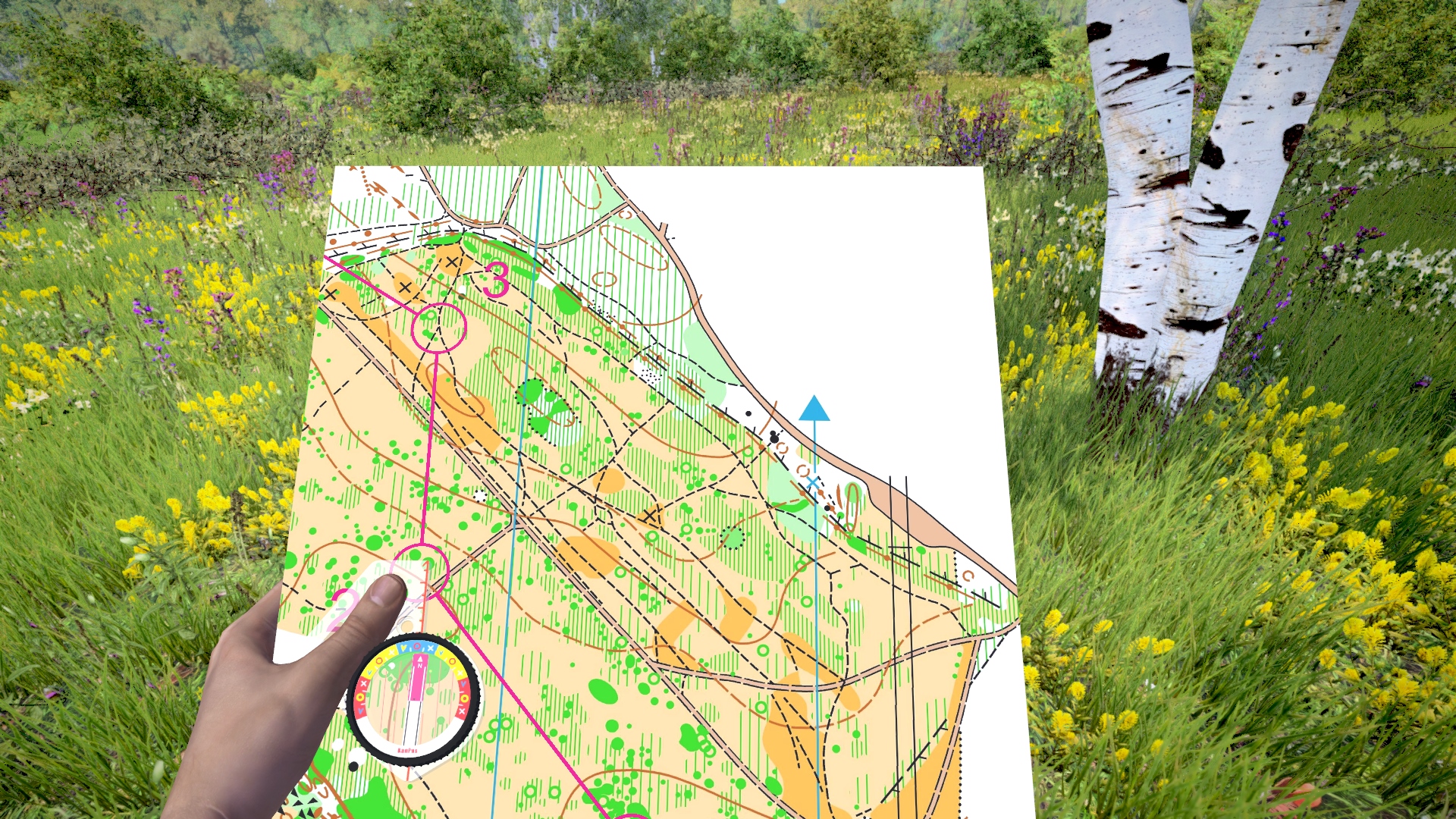
– [I like] the realistic looking terrain, as well as the general feeling of running through the forest. I also like the map handling assistants that make the game easier to control for beginners, allowing you to focus on the orienteering rather than the rotation and handling of the map, Jahren Samuelsen continues.
Jahren Samuelsen is an experienced Catching Features player, and explains that the main difference between Catching Features and Virtual-O is the superior graphics, more realistic forest and that the terrain forms in Virtual-O look pretty much like they do in the real terrain due to the use of LIDAR data.
He implemented several different map holding positions and let the community decide which one was best. His attention to detail is admirable (Øystein Jahren Samuelsen)
– Peter has also done great work on making the vegetation look right. There is a nice blend of different trees, bushes, grass and ferns, along with great looking forest textures, and it all looks very life-like. In CF there were often overly sharp edges between areas of different vegetation, which made it a little too easy to navigate compared to real orienteering. This is very much improved in Virtual-O. In short, Virtual-O feels much more like real orienteering than CF.
Still, Jahren Samuelsen is very impressed by what Greg Walker managed to do with Catching Features nearly 15 years ago.
– But I still want to stress that CF was a great achievement by a single developer (Greg Walker) back in 2003. The tools and assets that are available for game developers today are far superior to what Greg had to work with back then.
Many new features
When asked about new features since the last article about Virtual-O on World of O in September 2015, Furucz comes up with a long list.
- Running speed model (slope and map symbol based)
- Game modes (beginner, normal, elite)
- Reworked character controller and its physics (it uses now realistic physics, disabled drifting for turning)
- In-game menu (graphics settings, input controls mapping)
- Map holding options
- Added orienteering control model
- Kocbach map handling
- Time of day, night mode
- Curve based map penalty
- Visual course editor
- Thumb compass
- Map handling smoothing, map assistants
- Forest undergrowth
- Created two Facebook groups. Started to work with the community.
And yes, there is actually a “Kocbach map handling mode” in there – rotating and zooming the map around the tip of the thumb compass instead of around the centre of the map – based on feedback on the early access Virtual-O Facebook group from the author of this article and several others (There has to be someone else orienteering that way, though?).
Should implement a “horror mode” that would give the game a more interesting part for non orienteers and a fun alternative game mode for orienteers. Like a “slenderman” style game mode. You have a invisible monster chasing you (the closer the monster gets the more it affects music and vision) and to get more distance to the monster you have to complete the course. Each checkpoint/control gives you extra time/distance to the monster and you need to reach goal before the monster gets you. Ideally its all in nightmode where you run with a headlamp.
Will it be possible to turn the head (what you look at), without changing the direction you run in? I think that it is one of the most important features that is missing in CF – it would be great to have the option in Virtual-O.
Yes, this is definitely planned and requested feature. Exact implementation yet needs to be researched. Bit I would say that most probable option is simple look left or right with key press animated or not. And as long you will hold id pressed you will look at that side while still running.
There are other possibilities, but they are harder to handle by player. We will see what will community like to have.
I would like to volunteer the maps/terrains in Hvaler, Norway!
I have lidar elevation data for all of it, and pretty good mapping of vegetation and runnability, including bare rock patches.
Of course Virtual-O would be grateful for every map material usable for game.
Can I please ask you to contact me on facebook?
https://www.facebook.com/virtualosimulator/
Thanks
Peter
PS. I have logged into my Steam account and voted Yes. :-)
What sort of post-processing is needed to convert an OCAD map + elevation grid into a Virtual-O terrain?
I assume some sort of vegetation description, i.e. pine/spruce/birch etc?
Depends on workflow. LIDAR data is filtered to contain only ground in most cases. And than some interpolation is performed on it to get better result without spikes. And this surface is than imported as terrain. Depending on densify of points, than some post steps may be applied. For example for that rocky map I’m applying symbols that change elevation grid as LIDAR didn’t have enough density for ditches and small shapes.
For map objects, vegetation etc there exists symbol conversion set, where you basically specifies to what symbol will be converted. So you can for example choose x trees and bushes for symbol 405, choose scale range etc. If you know the process from CF it’s not same but similar.
And of course thanks for your vote. Virtual-O is getting really nice momentum!
Hi,
as not everybody here is using facebook. I’m here with some results after 36h of Steam Greenlight campaign.
And it’s pretty exciting:
Virtual-O now has 1550 Yes votes on Steam Greenlight. And its current rank is 39 of 2073 games in Greenlight!
And it’s still climbing. We can show orienteering to whole world!
Thanks
Thats impressive for just 36 hours :) As I understand they release greenlights in batches of 50, but how often? Looking forward to this.
On this website you can see chart of greenlig games. And as you can see it’s pretty random…
http://greendb.iygamestudio.com/
P.S.:
Virtual-O is now on rank 24 !
After some discussion with friends, would it be possible to develop a multiplayer mode where a server gets established and you can run virtual meets? How much more awesome would it be if we could compete against people from around the world real time? Local orienteering clubs could run events on a server as practice when the weather isn’t great.
Everything is possible. Game engine has comprehensive support for networking.
First step will be support for some kind of offline multiplayer mode similar to CF competitions. So you donwload map, run competition and results are uploaded to server. Where you will be able to compare routes, results against other people. Ranking can be calculated etc.
Realtime multiplayer:
This is another beast, problem is that realtime multiplayes is meaningful only if you have big enough base of users. Waiting in empty lobby is not very nice…
And if results of realtime multiplayer will be that only few percent of users will play it, than this would mean a waste of development time. That could be dedicated to more useful features of Virtual-O.
To make conclusion from all of this:
I would be really happy, if Virtual-O will have enough users in future, to make realtime multiplayer meaningful to implement.
It would be very nice to see something like Jukola or 10Mila happening in computer…
One thing that the CF multiplayer mode is useful for is coaching. I can follow an experienced player/orienteer (seeing him in the terrain and on the map) and he can explain his actions in real time (via Skype, for example). Or he can follow me and give me feedback, explain my mistakes etc. in real time as well. Something like this would probably be easier to implement than a full multiplayer mode and it would be a useful feature.
Another question/concern: given that Virtual-O is more sophisticated than CF, do you think it will ever be as easy for players to convert their own maps and create their own competitions? One great thing about CF is that new competitions are uploaded nearly every day. If it is much harder to make your own competitions in Virtual-O than in CF, then fewer people will do it and there will be fewer competitions uploaded, and playing on the same maps all the time will get boring pretty quickly.
Thanks, good to know about this way of using the multiplayer.
I will think about it.
I would be careful with words like Virtual-O is more sophisticated. I admire Greg’s work. I would say that he has done some things more sophisticated than I’m doing them now. As technology has advanced I can do some things simpler than in CF. For example I don’t need to do delanunay triangulation of terrain surface. (shader is drawing terrain on the fly with needed amount of detail based on heightmap)
I wouldn’t say too that Virtual-O will have more complicated work to do, than CF, because of better visuals. Tree is still tree only looks better, same for stones etc. It’s not so different.
But Virtual-O has still long way before its converter will be as automatic as converter from CF. For example now I’m not yet converting buildings. Now OCAD converter is living inside of game engine so its not accessible to users.
Still converting of maps is not easy in CF, people are doing miracles with it. I would say that something may be easier if you will be converting LIDAR based map in Virtual-O. As contours were time hungry to convert. LIDAR map is win win as it’s easier to convert and results in much better more realistic terrain.
I will release some article about future of Virtual-O. But basically here are some milestones to get basic idea (without dates, sorry :) ):
1. single player game with x-maps will move to early access
It will contain full core game simulation + course builder (some way of sharing courses?)
2. than given sufficient interest from users, I will work further on competition mode (offline multiplayer) + public or hybrid converter
3. future…
In few simple words I want to create playable base and than build more advanced features on it. In fact it’s same way how CF was created. OCAD converter was published some time after first release not sure how long it was.
P.S.: send me please an message on facebook:
https://www.facebook.com/virtualosimulator/
And I will add you to early access facebook group. Where you will be able to discuss new features, development. Simply you can influence there what Virtual-O will be.
Thanks
Peter