 World of O News
Todays leg in Route to Christmas is a long leg in technical Karst terrain in Croatia – and we even have the course planners thoughts about the leg included. The leg is from the leg 10 in the M21E course from day 3 of Croatia Open on July 5th 2009. Thanks a lot to Matjaz Stanfel for the introduction about the terrain and the analysis!
[PS! 8 Days – 8 Countries in Route to Christmas – how long can we keep up that…]
First a description about terrain, runnability and visibility in order to make it possible to choose the right route on the leg: The terrain is dominated by pine and beech forest with visibility from excellent (in white drawn forest up to 300 m) to poor (about 25 m) in dark green (ISOM 410.0). Path and road visibility is good, but sometimes less distinct small paths (ISOM 508.0) are hard to see because of fallen leaves. Paths are often used by orienteers with less technique skills to avoid demanding map reading in Karst labyrinths, and are also an important factor for long routes. Croatia open is a orienteering event traditionally held in highland Karst terrains of Gorski Kotar, dominated by many depressions combined with stony areas.
The leg is as usually first provided without routes – you may take a look at it and think about how you would attack this leg (if the image is too small, you may click on it to get it larger):
![]()
Webroute
Next you can draw your own route using the ‘Webroute’ below. Think through how you would attack this leg, and draw the route you would have made. Some comments about why you would choose a certain route are always nice for the other readers.
Then you can take a look at how the runners who have drawn their route choice solved this leg:
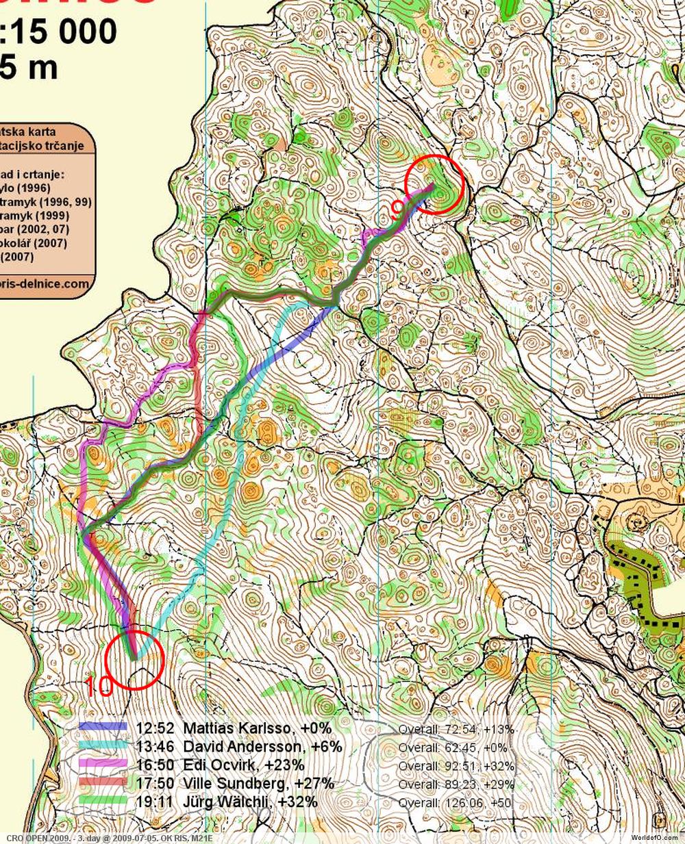
Analysis by the course setter – Matjaz Stanfel

Map with routes – updated 8/12/09 23:00 CET with new map from routeplanner
On this route there are several routechoices (see routes A-C on the map above). The first problem is if you will avoid the first hill with elevation of 35 m after crossing the road or not? This hill is stone-free and it is easy to climb but on the other hand you could run in full sped on almost flat roads and paths…
- Route A: By choosing to climb the hill, you will need to find a small path and follow it to the junction. From there you can run on a path, and until you reach the shooting platform you have minimum of map reading. From the shooting platform, all you need to do is to control your height for 360 m. This route is 1860 m long with 100 m of ascent.
- Route B:If you decided to take a longer route, you will need to follow paths, but with more junctions and curves, so you will still need to use your map reading skills. After the end of the paths (near the big open depression), you still have 600 m on which you have to control your height. Route B is 2110 m long with 105 m of ascent.
- Route C: Finally, I´m surprised that almost nobody decided to take the flattest route (route C). The beginning is a bit different from the first two routes: You decide to go east on paths. After crossing a big road, you will need to climb 20 m. When you get on a small path, you will need to follow it 920 m and then, after the shooting platform, you need to control your height. C is 2070 m long with 85 m of ascent.
David Andersson has chosen a more direct variant than A-C. This is also a good route choice – technically the hardest – but with too much elevation.
Complete map in Omaps.worldofo.com
You find the complete map and Routegadget info in omaps.worldofo.com at this location.
Omaps.worldofo.com
The ‘Route to Christmas’ series at World of O was very popular the two last year – and I’ve therefore decided to continue the series this Christmas as well. If you have got any good legs in RouteGadget from 2009-competitions – or old forgotten ones which are still interesting – please email me the link at Jan@Kocbach.net, and I’ll include it in Route to Christmas if it looks good. Route to Christmas will not be interesting if YOU don’t contribute.
There will be no analysis about the best routechoice for each leg – you can provide that yourself in the comments or in the Webroute. Not all legs are taken for the interesting routechoice alternatives – some are also taken because the map is interesting – or because it is not straightforward to see what to do on a certain leg. Any comments are welcome – especially if you ran the event chosen for todays leg!
Note that there may be some errors in the Routegadget data (sometimes somebody draws a route for another runner just for fun). Please add a comment below if you spot en error.


The control in “route to Christmas” is not at the same place than in the real race.
@Vincent: That’s looks strange – indeed. I’ve taken the Route to Christmas controls directly (and automatically) from RouteGadget – there shouldn’t be any room for error there. The “routeplanners choice” I’ve got from the routeplanner – I’m not sure how it was in the competition…
Indeed, I must have send Jan route from old file. – Sorry about that.
PS. I was only one of the course setters; together with Ivica Urbanc and Tihomir Salopek.
@Vincent & Matjaz: I now updated the article with a new map clip from Matjaz.