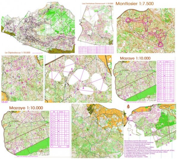
You seldom get the possibility to get this much insight into how the best teams set up their training camps – and especially not in as interesting terrain. The Czech and Swedish National Teams had a great training camp in France the last week (instead of participating at Spring Cup). Czech National Team trainer Radek Novotny presents all the trainings on the webpage of the Czech National Team. Definitely worth a look!
In addition to the two National Teams, there were also 10 other Swedish runners present, in addition to the French National Team/Thierry Gueorgiou in some trainings.
Swedish junior Albin Ridefeldt – attended some of the trainings later in the week, and describes the Clermont Ferrand area as Heaven: – After 4 days with fantastic orienteering I am convinced. Clermont Ferrand has the best orienteering terrain in the world. The terrain is difficult, green and terrible, but as long as you have full control, it is just wonderful! (see the latest maps from Albin Ridefeldt in omaps.worldofo.com here)
Maps and training manual
Ahead of the training camp, a detailed training manual was published, including details about the focus of each training. Based on the training manual and the maps from the trainings, I present the two trainings from the first day below – for the rest of the trainings and maps see links at the bottom of this page.
Moment training

A welcome session consisting of several different exercises, ended by a very short sprint. The main goal was to get familiar with the terrain and map, as well as to get the importance of compass work under such visibility conditions. The training was divided into 5 parts in addition to the sprint in the end:
- A: corridor-O (~1800m). This type of corridor training has gotten very popular lately due to the GPS analysis after the training making it straightforward to analyze how well you managed (and the ease of making this type of trainings in OCAD).
- B: direction changes in a green area. (1340m)
- C: vegetation-O; learn to use or avoid green and yellow.(570m)
- D: relax/transport (on/off practice, refocus at start point, 700m)
- E: curves (learning to understand the curves, 1770m)
- F: ultrasprint (separate map – see Albin Ridefeldts map here)
Click the downscaled map above to see all of the map – or see Albin Ridefeldts GPS track from the training here.
(Near impossible) direction training

On the trainig maps most of the area was blinded, except the ovals around the controls (blue in the map). – Most runners spent one and half hour in the biting vulcanic kingdom. But, you always learn something, even from an extreme, according to the report by Novotny. This was the second low speed session of the first day, which turned into a real challenge as the Vulcania area makes both the direct running and relocations quite difficult for everyone. See the map here (the blinded areas are shown on this map). This is another type of training which has been used more and more the last year.
All maps
You find all trainings described below. Expect to find more of the trainings with the participating runners GPS tracks in omaps.worldofo.com during the coming week (a comparison of GPS tracks from different runners will be possible from omaps.worldofo.com soon).
- Maps from all trainings in omaps.worldofo.com
- Maps from all trainings, including description of the trainings and results at the Czech National Team webpage
- Training manual (published ahead of the training camp) including details about the focus of each training, how to find the training, etc.
 World of O News


It would be nice to have an article – a guide on preparing different technical trainings in OCAD – like, for example, those presented in this article. Time form time I try to make such OCAD adjusted maps, however I am not sure if I am doing the things right way, and maybe sometimes those adjustments (making coridors, making part of map just contours, or levaing just green areas) can be done in much more easier way than I am doing this. I guess there are also orienteers who are not familiar with OCAD at all, so this could be great new knowledge for them to imrpove their trainings.
I agree with REANRS, I would find such an article very interesting!
@Renars and Jens: I’ve got a half-finished article as part of a project which I started a long time ago and never got out the door. I’ll try to push it a bit and get it out!
I agree with REANRS, I would find such an article very interesting!
I think this might help you a bit.. http://o-training.net/w/Tips_on_OCAD_usage
@Raakel: Yes, that’s the half-finished article I was writing about, which is now finished. Thanks for providing the link here:)