Todays leg in Route to Christmas is one of the nominations for Course of the Year 2011 – featuring Thierry Gueorgiou and Marc Lauenstein – two of the runners nominated for The Orienteering Achievement of 2011. Thanks to Benoit Cochey for the tip.
We have headed over to France – to one of the preparation races for the World Orienteering Championships on May 8th. The race was held close to Grenoble, and the terrain has some of the same characteristics as the WOC terrain although the runnability is a bit better. Still, the white areas are not very fast, and paths are absolutely your friend in this area. The chosen leg is leg number 3 in the Men 21E course.
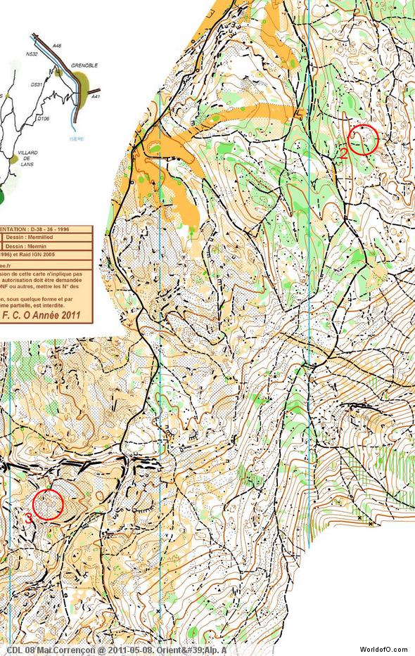
The leg is as usually first provided without routes – you may take a look at it and think about how you would attack this leg (if the image is too small, you may click on it to get it larger):
Webroute
Next you can draw your own route using the ‘Webroute’ below. Think through how you would attack this leg, and draw the route you would have made. Some comments about why you would choose a certain route are always nice for the other readers.
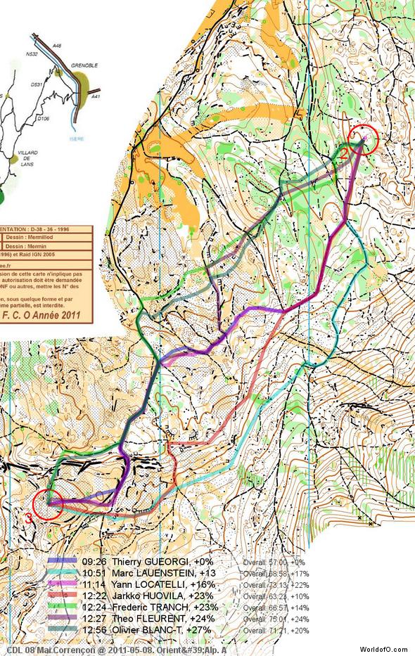
Then you can take a look at how the runners who have drawn their route choice solved this leg. As you can see Thierry Gueorgiou crushes the competition on this leg even if there are quite a few good runners present – being nearly 1:30 faster than Marc Lauenstein on this leg. Looking at the route of Gueorgiou – it is probably not a route you would choose if you have not got intimate knowledge of this terrain type. I bet not too many of you chose that route?
The key to this route being fast seems to me to be (1) a lot of path running, (2) saving altitude where possible and mainly (3) how the fast (and easier to navigate), yellow areas are exploited in the middle part of the leg. The route of Lauenstein has about as much path running, but Lauenstein (1) looses some time early on the leg in addition to (2) some uncertainties on the way, and he has (3) poorer runnability and more difficult orienteering in the parts without paths (based on on the GPS-data, see below). The speed of Lauenstein in areas where he and Gueorgiou have taken the same route is not very much slower (again from the GPS-data earlier in the course) – thus running shape does not explain the big difference.
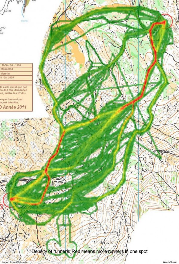
Looking at the other alternatives on this leg, the northern variant which several runners have choosen has also poorer runnability in the areas without paths compared to Gueorgiou’s route.
Bonus material: GPS analysis for the “o-nerds” out there
In addition to the usual comparison of routes from Routegadget, I have provided some extra GPS-analysis today thanks to GPS-data being available. Below you see first an autOanalysis between Gueorgiou and Lauenstein where each point they would have reached at the same time if they started together from the start of the leg is connected with a line. As you can see, Lauenstein looses a lot of time early on the leg due to seemingly missing the path. He also has lower speed in the non-path areas as well as on the path with uphill.
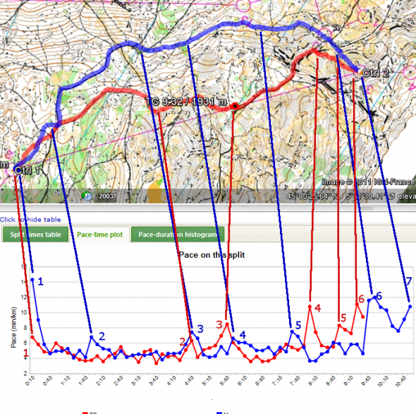
Below the autOanalysis, another illustration is shown – this one taken from 3DRerun. Looking at the pace in the terrain sections, Gueorgiou has a pace of just above 4 min/km, while Lauenstein is often up in 5:30 to 6:00. I have also annotated all places where either Lauenstein or Gueorgiou have slowed down significantly (the pace versus time graphs at the bottom of the illustration). Several of Lauensteins slow-downs here seem to be due to insecurity related to the orienteering – often close to path junctions like blue point 2, 3, 4 and 6 (note also the time loss at the start of the leg, point 1) – this might indicate not being ahead with the orienteering. These probably cost at least 30+ seconds. Gueorgiou’s slow-downs are typically in stony areas or areas with cliffs like red point 2, 3 and 4 (and so are a few of Lauensteins like blue points 5). Still Gueorgiou’s route is faster, but probably more like 30 seconds than 1:30 I would say. Also, if not executed with care regarding exploiting the possibilities for simplification in the terrain-parts on Gueorgiou’s route, I would expect that there is even less to gain. But that’s just my personal opinion – I’ve never even been in the terrain. Please add a comment below if you have something to add – especially if you disagree with my analysis – you can even play with the GPS-data below :-)
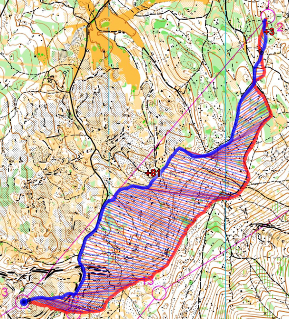
If you are adventurous, you can try the direct link to the autOanalysis of this leg for Gueorgiou versus Lauenstein in 2DRerun, a replay of the race development between them from the start (press “Play”) or an autOanalysis between them for the complete course (Note! 2DRerun is in early test version and works only in Google Chrome, Firefox and on the iPad – does not work in Internet Explorer). You can also try it out in 3DRerun.
“O-community’s choice”
This density map shows what the 200 first drawing their route chose.
Complete map in Omaps.worldofo.com
You find the complete map and Routegadget info in omaps.worldofo.com at this location.
Omaps.worldofo.com
The ‘Route to Christmas’ series at World of O has been very popular the last years – and I’ve therefore decided to continue the series this Christmas as well. If you have got any good legs in RouteGadget from 2011-competitions – or old forgotten ones which are still interesting – please email me the link at Jan@Kocbach.net, and I’ll include it in Route to Christmas if it looks good. Route to Christmas will not be interesting if YOU don’t contribute.
There will be no analysis about the best routechoice for each leg – you can provide that yourself in the comments or in the Webroute. Not all legs are taken for the interesting routechoice alternatives – some are also taken because the map is interesting – or because it is not straightforward to see what to do on a certain leg. Any comments are welcome – especially if you ran the event chosen for todays leg!
Note that there may be some errors in the Routegadget data (sometimes somebody draws a route for another runner just for fun). Please add a comment below if you spot en error.
 World of O News
