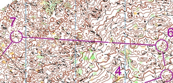
Todays leg in Route to Christmas is a celebration of the winner of the Course of the Year 2011 which was announced today. Thus we visit France for the second day in a row – and some of you might already be familiar with this leg.
The course in question is the WOC middle distance organized in Le Feclaz, France. The leg is as usually first provided without routes – you may take a look at it and think about how you would attack this leg (if the image is too small, you may click on it to get it larger). Remember that this is tricky terrain with not the best runnability.
When choosing a route in this type of terrain, focus is often on (1) a safe attackpoint for the control, (2) good runnabililty along the chosen route, (3) choosing a route for which you can simplify your orienteering, i.e. identify features which you can easily spot from a distance to make it possible to keep higher speed without reading all features along your route.
Webroute
Next you can draw your own route using the ‘Webroute’ below. Think through how you would attack this leg, and draw the route you would have made. Some comments about why you would choose a certain route are always nice for the other readers.
Webroute
Next you can draw your own route using the ‘Webroute’ below. Think through how you would attack this leg, and draw the route you would have made. Some comments about why you would choose a certain route are always nice for the other readers.
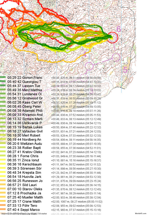
Then you can take a look at how the runners solved the leg (see a more complete analysis of the course here). For this particular course there was full GPS coverage on all runners, and thus we have a lot of information about the choices of the runners. We first take a look at the routes of all runners colored by split time. As you can see, there were a lot of mistakes on this leg – and thus finding a route which made the orienteering manageable was one key point here.
Next we take a look at the 8 fastest runners.
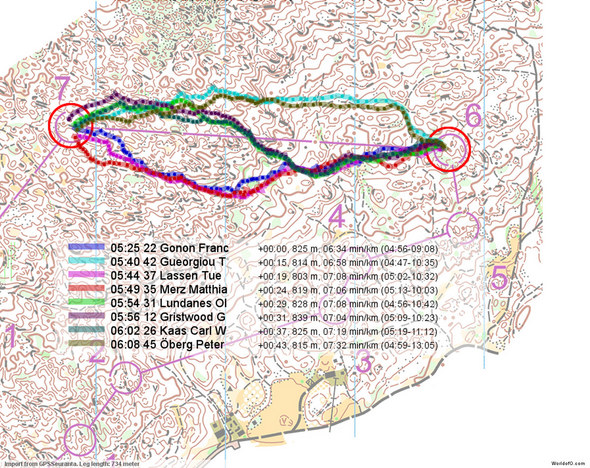
There are three different routes used by the fastest runners:
- The southern variant used by Gonon, Merz and Lassen – three of the four fastest times. This is a variant with quite a lot of path running, and attackpoints which seem quite good on the map.
- The northern variant used by Gueorgiou (second fastest on the split – winner overall) and Öberg (8th time on the split – second overall). This variant has a bit less path running, but a very nice and easy first part of the leg. The last third of the leg is however more tricky along this route – especially the transition between the two paths. This seems to be an area where some of the big mistakes started. Interesting to see that the two top finishers choose this variant.
- The middle variant which goes like an S from the southern to the northern variant. Waaler Kaas, Lundanes and Gristwood used this variant. This var exploiting more path running, but is longer than the other variants. It might be considered as a safer variant due to more path running, but I would say you don’t really avoid any of the main difficulties on the leg with this route, so I would say this is not the optimal choice.
Based on the routes run, I would say the southern variant is the best choice. A majority of the fastest runners on the split choose this variant, and it is possible to find safe attackpoints.
The riskyness of the northern variant is illustrated very well through the below illustration from 2DRerun. Here all runners which have not made a big, big mistakes are compared – routes colored by split time. As you can see, the ones with bad split times have generally chosen the northern variant.
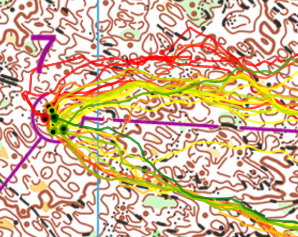
Finally a dot-comparison between Gonon and Gueorgiou. It is in the last third of the leg Gonon’s is faster and gains time on Gueorgiou. Gueorgiou said the following about the leg: – I forced myself to not start walking up that long hill. I lost control for some second on the way, but I regained control quite fast.
“O-community’s choice”
This density map shows what the 200 first drawing their route chose.
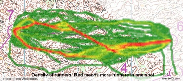
Complete map in Omaps.worldofo.com
You find the complete map and Routegadget info in omaps.worldofo.com at this location.
Omaps.worldofo.com
The ‘Route to Christmas’ series at World of O has been very popular the last years – and I’ve therefore decided to continue the series this Christmas as well. If you have got any good legs in RouteGadget from 2011-competitions – or old forgotten ones which are still interesting – please email me the link at Jan@Kocbach.net, and I’ll include it in Route to Christmas if it looks good. Route to Christmas will not be interesting if YOU don’t contribute.
There will be no analysis about the best routechoice for each leg – you can provide that yourself in the comments or in the Webroute. Not all legs are taken for the interesting routechoice alternatives – some are also taken because the map is interesting – or because it is not straightforward to see what to do on a certain leg. Any comments are welcome – especially if you ran the event chosen for todays leg!
 World of O News
