 World of O News
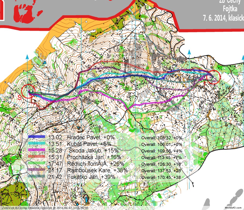
Todays leg in Route to Christmas is one of those legs where it feels like there is no route which is really good. A long leg in very stony terrain. The paths looks like they are too far away from the line – but on the other hand the more direct routes look very stony. What would you do here?
The leg is from Czech Republic – found through RouteGadget. The leg is as usually first provided without routes – you may take a look at it and think about how you would attack this leg (if the image is too small, you may click on it to get it larger):
![]()
Webroute
Next you can draw your own route using the ‘Webroute’ below. Think through how you would attack this leg, and draw the route you would have made. Some comments about why you would choose a certain route are always nice for the other readers.
Then you can take a look at how the runners who have drawn their route choice solved this leg. It is difficult to make any clear conclusions based on the RouteGadget material available due to the variation in level of the runners, but it may look like going quite straight like Pavel Hradec does is the best choice – even with the stony ground. What do you think?
Complete map in Omaps.worldofo.com
You find the complete map and Routegadget info in omaps.worldofo.com at this location.
Density map
See below for a density map of some of the ones who have drawn their routes so far.

Additional information
You find the complete map in omaps.worldofo.com at this location. See also Split times here.
Route to Christmas series
The Route to Christmas series at World of O has been very popular the last years – and I have therefore decided to continue the series this Christmas as well. If you have got any good legs in RouteGadget, GPSSeuranta or 3DRerun from 2014-competitions – or old forgotten ones which are still interesting – please email me the link at Jan@Kocbach.net, and I’ll include it in Route to Christmas if it looks good. Route to Christmas will not be interesting if YOU don’t contribute.
Not all legs are taken for the interesting routechoice alternatives – some are also taken because the map is interesting – or because it is not straightforward to see what to do on a certain leg. Any comments are welcome – especially if you ran the event chosen for todays leg!
Note that there may be some errors in the Routegadget data (sometimes somebody draws a route for another runner just for fun). Please add a comment below if you spot en error.


If direct is fastest, then the stony ground pattern should have been less dense! As it is now the map don’t seem to indicate true runnability.
A half-careful look at the fastest route, seems to show that despite the abundance of stoney ground in the area, very little stoney ground was actually crossed, perhaps on the order of 5-10 dots worth.
This relatively direct route is also very climb- efficient. No surprise to me that this route paid off handsomely
It is also interesting that both controls are on near-beginner features, yet there are big time differences both in route choice,as well as detailed map reading en route, to avoid stones and climb and green.
I think this is a fantastic example of what is possible in a Long format style leg.
Possibly more on the mapping issue on the relevant Attackpoint thread.