 World of O News
Today we offer a 23 year old “classic” leg – which has been used as an example in the Norwegian course setting book (“Løypeleggerboka”) as an example of a good leg according to my source. The special thing about this leg – and the reason for it appearing in Route To Christmas in 2014 – is that the leg was reused at a regional championship in 2014. The leg in question is 11th leg in the M21 course from KM Lang 2014 for the “Sør-Trøndelag” region – organized August 23rd 2014.
I received an e-mail about the leg and the course earlier this year from the course setter from 1991 (Agnar Reolen). He told me that they decided to use the same course as in 1991 – with some modifications. You can see the complete courses from 1991 and 2014 below the analysis of today’s leg. The winning time in 1991 was 10 minutes faster than this year. In 1991 the winner was the legendary long distance orienteer Håvard Tveite – this year Øyvind Enger won with middle distance specialist Bjørn Ekeberg in third. The terrain has probably changed – and the course is not exactly equal – so with no GPS data from 1991, we can’t do a real comparison unfortunately. But still, feel free to speculate in the comments :)
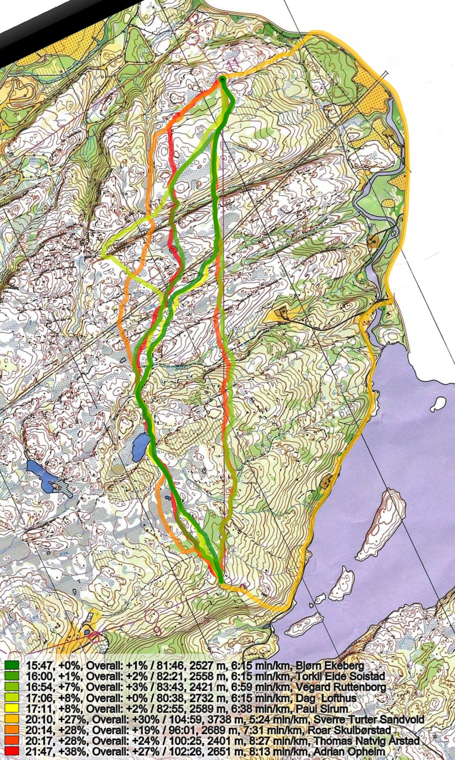
The leg is as usually first provided without routes – you may take a look at it and think about how you would attack this leg (if the image is too small, you may click on it to get it larger). Remember, this is quite tough Norwegian terrain – still the marshes are usually the best runnable part of the terrain – and in addition the marshes is used a lot for navigation – using the marshes extensively for navigation makes the orienteering easier.
![]()
Location
You find other maps from the area in omaps.worldofo.com here. See also latest additions in 3DRerun from this area in order to learn more about this terrain type.
Webroute
Next you can draw your own route using the ‘Webroute’ below. Think through how you would attack this leg, and draw the route you would have made. Some comments about why you would choose a certain route are always nice for the other readers.
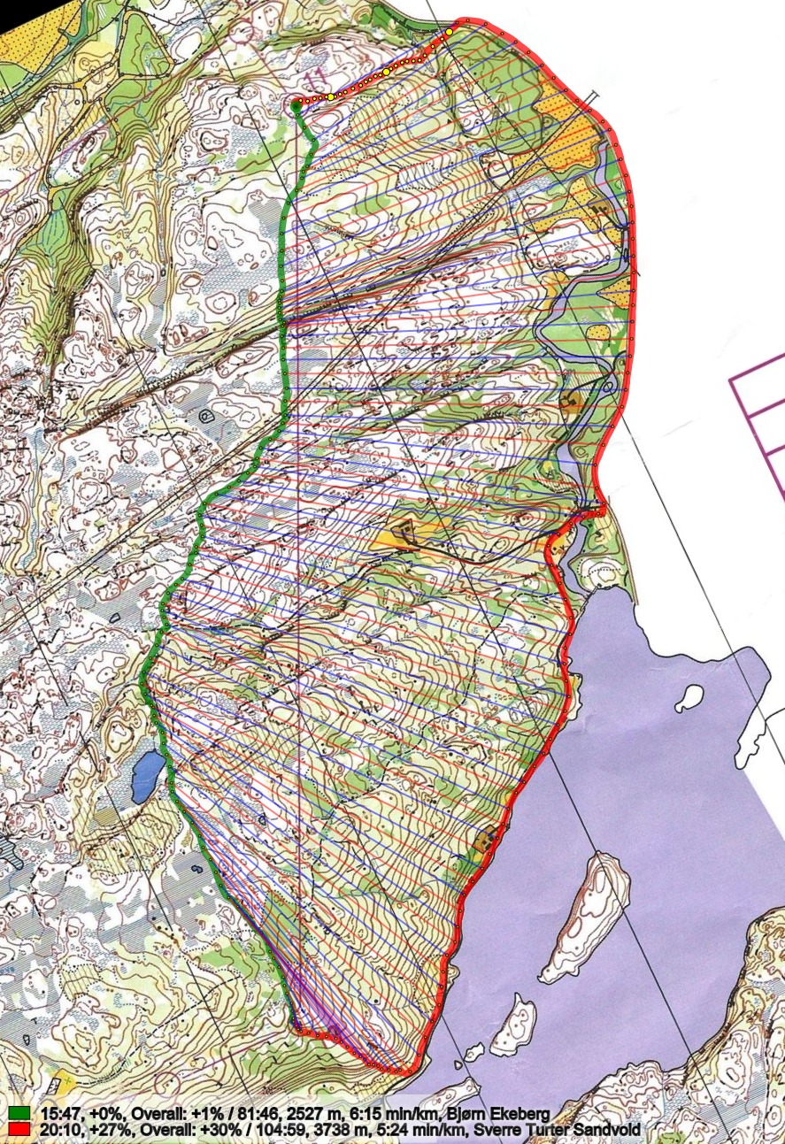
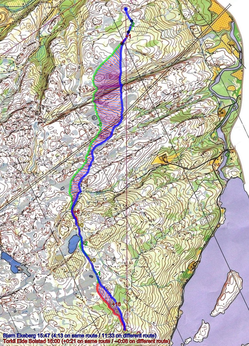
Then you can take a look at how the runners have solved this leg below. The quick analysis is that direct is too slow – too much up and down. Going all the way around on the road looks like it loses you a bit of time – but actually not that much. The best route is probably a variant like Ekeberg and Solstad run – this is also the variant the course setter from 1991 thought was the best at that time according to his e-mail. However, he also says in his e-mail that today (in his current shape) it would probably be better for him to take the road, but he still took a route similar to Ekeberg’s route because all the road running hurts the legs a lot …
I didn’t have the “Løypeleggerboka” handy – maybe they write something about the best route there? What do you think?

Density map
See below for a density map of some of the ones who have drawn their routes so far.

Additional information
You find the complete map with the course from 2014 in omaps.worldofo.com at this location – the course from 1991 is available here for comparison.
Results from 1991 below – from 2014 here.

Route to Christmas series
The Route to Christmas series at World of O has been very popular the last years – and I have therefore decided to continue the series this Christmas as well. If you have got any good legs in RouteGadget, GPSSeuranta or 3DRerun from 2014-competitions – or old forgotten ones which are still interesting – please email me the link at Jan@Kocbach.net, and I’ll include it in Route to Christmas if it looks good. Route to Christmas will not be interesting if YOU don’t contribute.
Not all legs are taken for the interesting routechoice alternatives – some are also taken because the map is interesting – or because it is not straightforward to see what to do on a certain leg. Any comments are welcome – especially if you ran the event chosen for todays leg!
Note that there may be some errors in the Routegadget data (sometimes somebody draws a route for another runner just for fun). Please add a comment below if you spot en error.


Speculation about slower winning times this year. Blame it on the map. Compare the map from this year to the map of 1991. Print of the 2014 map is awful. It’s hard to believe my eyes that 20 years ago it was much better. A second guess is that the condition of marshes were very different in those years. And the 3rd guess (perhaps most realistic) is that the runners participating this year were not so good.
Thanks for your comment, AK! Not sure if the map printing could be the reason – not for that big a difference. The marshes could be an issue – it would be nice to see some actual split times from the good old days. I’ve send an e-mail to Håvard – maybe he brought along a Casio watch?