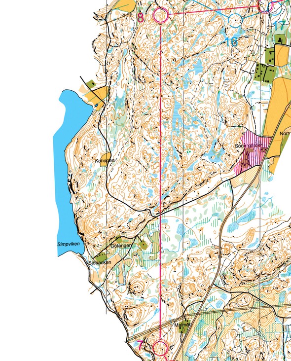
Helena Jansson offers us a very interesting long leg in tough Swedish terrain for today’s leg in Route to Christmas. The is the 8th leg in the D21E course from the Swedish Championships Long 2015 at September 13th.
For me the whole race was a bit special, since it was my first long-distance race in about a year an a half
Helena first gives a small introduction to the leg – and a setting:
This is the longest leg we had during the Swedish long distance champs this year. For me the whole race was a bit special, since it was my first long-distance race in about a year an a half. Usually a leg like this is hard because of several aspects. You want to find a good route, but in order to do so you need to keep calm enough to invest time into planning the leg properly. You need to know yourself, know what your strengths and weaknesses are. During a long-distance you might also have to consider taking a route that is tactically good, meaning a route that is not too tough or too technically demanding if you risk being too tired in the end of the course.
The leg is as usually first provided without routes – you may take a look at it and think about how you would attack this leg (if the image is too small, you may click on it to get it larger):
Location
You find other maps from the area in omaps.worldofo.com here. See also latest additions in 3DRerun from this area in order to learn more about this terrain type.
Webroute
Next you can draw your own route using the ‘Webroute’ below. Think through how you would attack this leg, and draw the route you would have made. Some comments about why you would choose a certain route are always nice for the other readers.
Helena starts here analysis of the leg with some information about her preparations for the race:
– For me, this leg was surprisingly easy to solve. I had looked at the old map before the race, and since Muskö is an island, the number of alternatives for good route choices were limited. We had discussed a variant of this leg before, and from that discussion I felt quite certain about what I should do. Also, during the race we had a long leg to the 6th control, and I chose a route going around on a road, hence I had plenty of time to plan the next long leg (and actually all legs left before the map exchange).
Thus as the saying goes: “Everything is in the preparations”. Here is Helena’s choice – and her reasoning behind it:
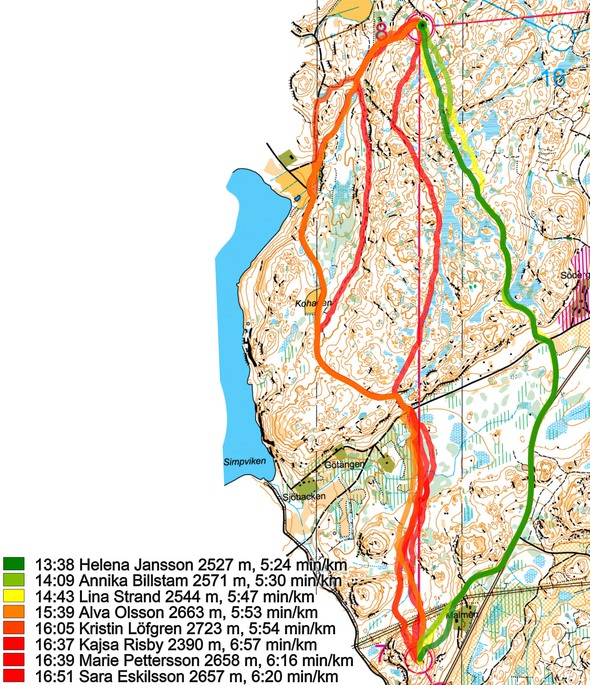
– I chose to go right, down to the road, and then on a small path up until just a few hundred meters before the control. I knew that left meant a lot more climbing (even though the control would be easy to take), and I was uncertain about how the runnability in the forest would be in the flat area just north of C7. Also, right looked easy enough, with nice difficult orienteering coming up to the control, and after some quite easy orienteering so far during the course I was longing for some technical challenge. Usually in Stockholm going straight is always good, and you need a fairly good reason not to follow the line. This time my decision was also one of trying to be smart and safe. I thought that straight might be the fastest if you do it really well, but it is a higher risk. Since it was a long-distance, I thought it wise to take a route that I knew would be good enough but with low risk of failing. The men did not have a similar leg at all (maybe because they would have all run straight?)
Then you can take a look at how the runners have solved this leg below. As you can see, going right is definitely faster. The fastest runner going left or direct is nearly 2 minutes slower than Helena. And even if Helena is the fastest in the field on this day, it is clear that right is definitely faster. Below the first illustration there is further analysis about why.
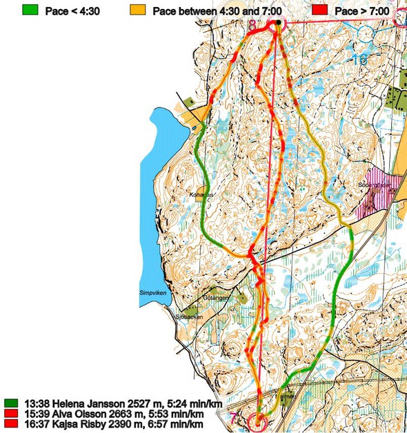
Looking at why left is so much slower, there are three reasons: (1) there is more road running to the right, (2) There is more climb going left and (3) there is more going in slow terrain to the left. The below running speed analysis for the three route choices illustrates this nicely. The range where you can run faster than 4:30 min/km is marked in green – significantly larger area to the right. Note also to the right that Helena runs faster than 7:00 min/km all the way on the small path after leaving the road, whereas elsewhere in the terrain all runners shown struggle with being constantly below 7:00 min/km.
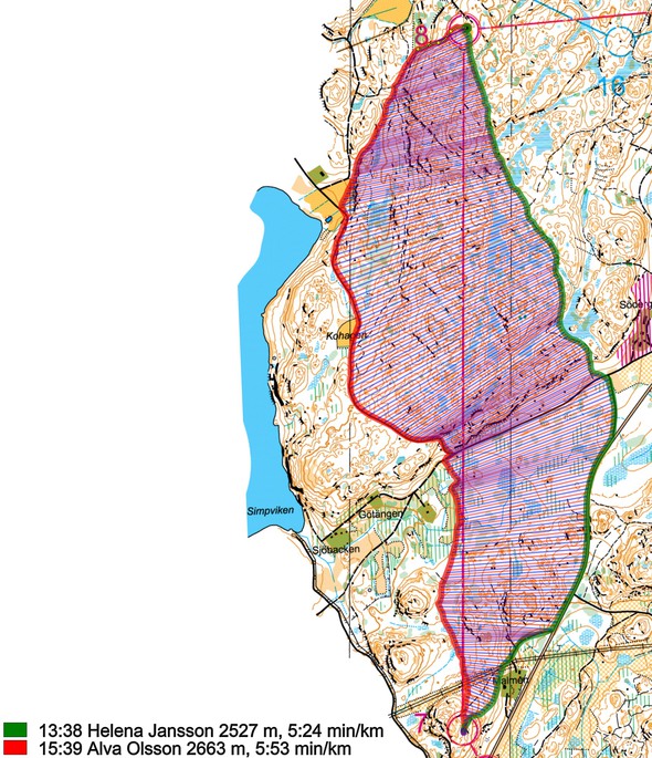
Finally a dot-comparison of left and right.
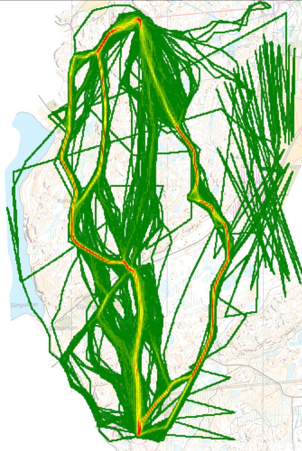
Density map
See below for a density map of some of the ones who have drawn their routes so far.
Usually in Stockholm going straight is always good, and you need a fairly good reason not to follow the line.
Thanks a lot to Helena for a nice leg and a great analysis. It is very nice to get some insight into how the top runners plan their legs – this gives Route to Christmas another dimension!
Additional information
You find the complete map in omaps.worldofo.com at this location.
Route to Christmas series
The Route to Christmas series at World of O has been very popular the last years – giving the readers the opportunity to do one Route Choice Challenge each day from December 1st until December 24th. If you have got any good legs in RouteGadget, GPSSeuranta or 3DRerun from 2015-competitions – or old forgotten ones which are still interesting – please email me the link at Jan@Kocbach.net, and I’ll include it in Route to Christmas if it looks good. Route to Christmas will not be interesting if YOU don’t contribute.
Not all legs are taken for the interesting routechoice alternatives – some are also taken because the map is interesting – or because it is not straightforward to see what to do on a certain leg. Any comments are welcome – especially if you ran the event chosen for todays leg!
 World of O News
