 World of O News
For today’s leg in Route to Christmas we travel to a very interesting sandstone area in Czech Republic. The chosen leg is leg 10 in the M21 course from Prague Easter organized at April 4th 2015. Thanks to Dag Lofthus for the tip.
The terrain was very nice. A bit slippery on the steep hills and some small areas with fallen trees.
Hans Petter Mathisen – one of the fastest runners on this particular leg – comments about the terrain: – The terrain was very nice. A bit slippery on the steep hills and some small areas with fallen trees. You could see very far in white forest. Generally quite easy to use the vegetation for orienteering.
The leg is as usually first provided without routes – you may take a look at it and think about how you would attack this leg (if the image is too small, you may click on it to get it larger). Generally in this kind of terrain it is all about understanding where it goes up and down – to be able to avoid extra climb.
![]()
Location
You find other maps from the area in omaps.worldofo.com here. See also latest additions in 3DRerun from this area in order to learn more about this terrain type.
Webroute
Next you can draw your own route using the ‘Webroute’ below. Think through how you would attack this leg, and draw the route you would have made. Some comments about why you would choose a certain route are always nice for the other readers.
Then you can take a look at how the runners have solved this leg below.
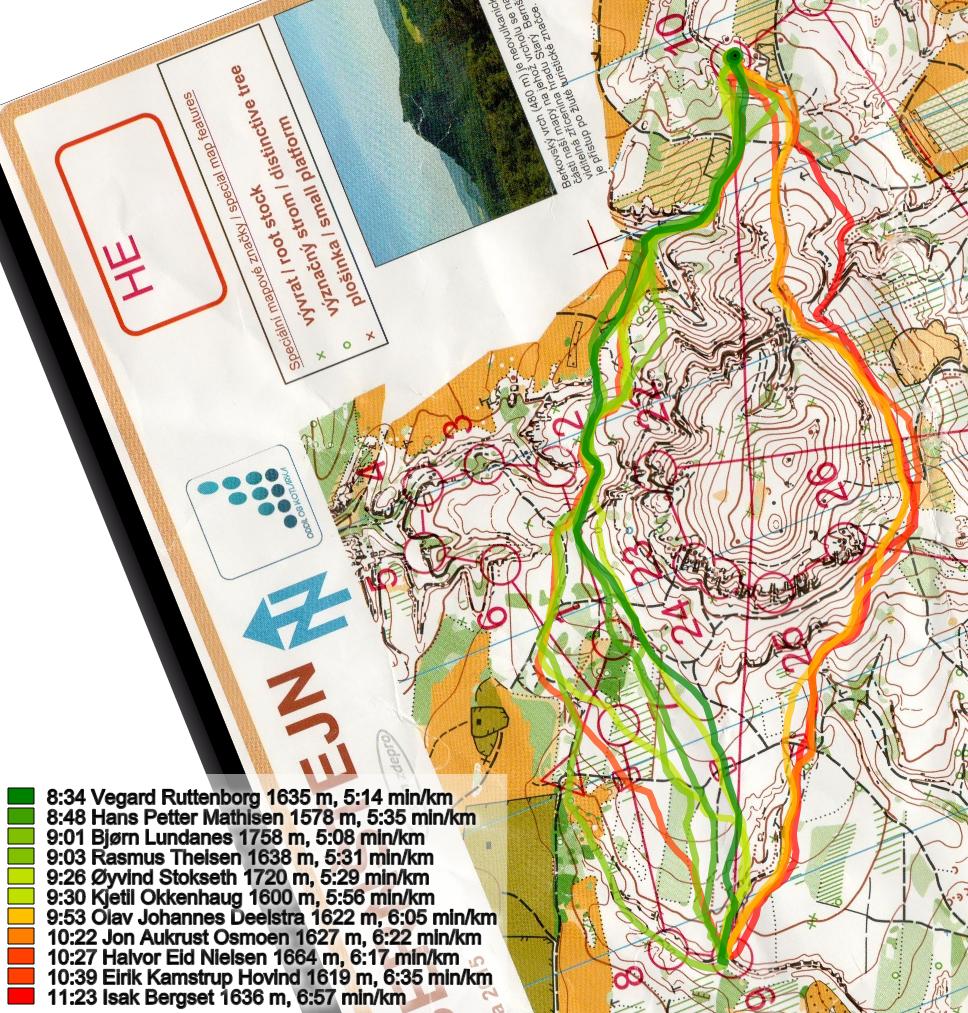
Looking at the routes above, it seems clear that you lose around a minute or by going to the right. Below is a comparison of the fastest runner going left and the fastest runner going right. As you can see the right side is slower because there is a little bit more climb – but mostly because you have to run in a quite steep slope. The last part being downhill and fast does not help – then the time is already lost.
Here is a pace comparison of all runners. Again you see how none of the runners manage to keep high speed in the slope on the right hand side of the hill, even if you don’t take much extra height in that region.
The question is: Why do so many go to the right in this steep slope? It will be interesting to see if World of O’s readers tend more towards left …

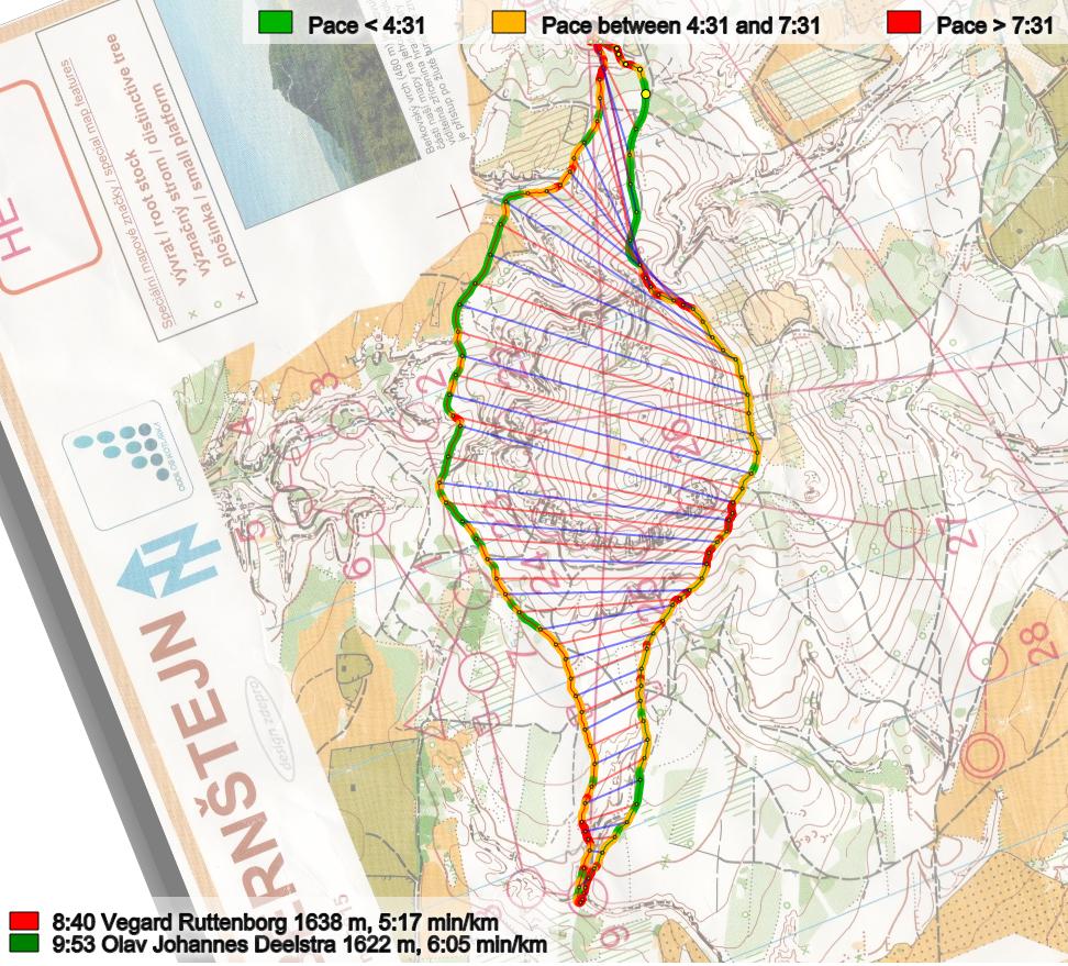
Density map
See below for a density map of some of the ones who have drawn their routes so far.

Additional information
You find the complete map in omaps.worldofo.com at this location.
Route to Christmas series
The Route to Christmas series at World of O has been very popular the last years – giving the readers the opportunity to do one Route Choice Challenge each day from December 1st until December 24th. If you have got any good legs in RouteGadget, GPSSeuranta or 3DRerun from 2015-competitions – or old forgotten ones which are still interesting – please email me the link at Jan@Kocbach.net, and I’ll include it in Route to Christmas if it looks good. Route to Christmas will not be interesting if YOU don’t contribute.
Not all legs are taken for the interesting routechoice alternatives – some are also taken because the map is interesting – or because it is not straightforward to see what to do on a certain leg. Any comments are welcome – especially if you ran the event chosen for todays leg!


One reason people go right could be that the line between the controls is (wrongly) bent that way.
That is a good point, Bernt. Thanks a lot for your comment.
I agree with BOM, the bent connecting line is a big mistake: It would have been much better to use a straight line but with a bend in the middle to show that you should not visit either 23 or 24 at this time. This way makes it much easier to visually determine how far off a given route choice will be.
I also noticed that (as usual!) very few runners noticed the good route alternative that passed the start, and of those shown here, nobody ran all the way around the left on the starting field which would probably have been even faster!
It is possible though that the race map had an OOB area over the starting warmup field?
Is there an official rule about lines going through control circles? Is bending allowed? Should the line be broken where it crosses the circle?
There is a general rule stating that the connecting line should only be bent away if the runners are forced to go through a specific crossing point. I.e. with a leg crossing a lake, and only the south side of the lake shown on the map, then it is OK to let the connecting line go around the south end of the (uncrossable obviously) lake.
There is also a general recommendation that control circles and connecting lines should be edited to avoid obscuring any important details that might end up under the purple print.
In this particular case a straight line would have gone through the control 23-24 area, obscuring lots of stuff, so just deleting that part of the line would have been OK, except that this might have looked like you were supposed to visit one of those two controls on the way: Making a bent/curved section of the connecting line which passed over the same place as on the map, but with straight lines pointing in the correct direction for most of the leg would have been best IMHO.
Going left looked more complicated and I didn’t notice the climb difference straight away. On second thoughts, Left is quite easy because you can run without thinking till you hit the field east of #2.
Will a density Map bee added :-)
There you are – updated. Thanks for letting me know.